
Alabama is a state in the Southeastern region of the United States, bordered by Tennessee to the north; Georgia to the east; Florida and the Gulf of Mexico to the south; and Mississippi to the west. Alabama is the 30th largest by area and the 24th-most populous of the U.S. states.

Mobile is a city and the county seat of Mobile County, Alabama, United States. The population within the city limits was 187,041 at the 2020 census, down from 195,111 at the 2010 census. After a successful vote to annex areas west of the city limits in July 2023, Mobile's population increased to 204,689 residents. It is now the second-most-populous city in Alabama, after Huntsville.

Baldwin County is a county located in the southwestern part of the U.S. state of Alabama, on the Gulf coast. It is one of only two counties in Alabama that border the Gulf of Mexico, along with Mobile County. As of the 2020 census, the population was 231,767. The county seat is Bay Minette. The county is named after the founder of the University of Georgia, Senator Abraham Baldwin.

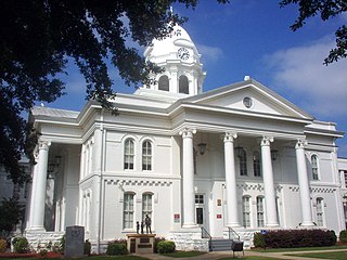
Choctaw County is a county located in the southwestern portion of the U.S. state of Alabama. As of the 2020 census, the population was 12,665. The county seat is Butler. The county was established on December 29, 1847, and named for the Choctaw tribe of Native Americans.
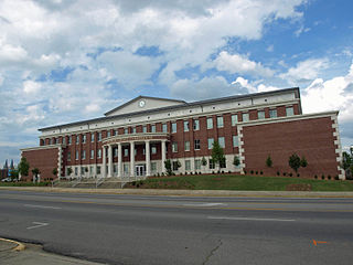
Colbert County is a county located in the northwestern part of the U.S. state of Alabama. As of the 2020 census the county's population was 57,227. The county seat is Tuscumbia. The largest city is Muscle Shoals.
Cullman County is a county located in the north central portion of the U.S. state of Alabama. As of the 2020 census, the population was 87,866. Its county seat and largest city is Cullman. Its name is in honor of Colonel John G. Cullmann.

Lawrence County is a county in the northern part of the U.S. state of Alabama. As of the 2020 census, the population was 33,073. The county seat is Moulton. The county was named after James Lawrence, a captain in the United States Navy from New Jersey.

William Rufus DeVane King was an American politician and diplomat. He was the 13th vice president of the United States from March 4 until his death in April 1853. Earlier he had served as a U.S. representative from North Carolina and a senator from Alabama. He also served as minister to France under President James K. Polk.

Union Springs is a city in and county seat of Bullock County, Alabama, United States. The population was 3,980 at the 2010 census.
Tuscumbia is a city in and the county seat of Colbert County, Alabama, United States. As of the 2010 census, the population was 8,423. The city is part of The Shoals metropolitan area.

John Jackson Sparkman was an American jurist and politician from the state of Alabama. A Southern Democrat, Sparkman served in the United States House of Representatives from 1937 to 1946 and the United States Senate from 1946 until 1979. He was the Democratic Party's nominee for vice president in the 1952 presidential election.

Clement Comer Clay was the eighth Governor of the U.S. state of Alabama from 1835 to 1837. An attorney, judge, and politician, he also was elected to the state legislature, as well as to the House of Representatives and the United States Senate.

The William B. Bankhead National Forest is one of Alabama's four National Forests, covering 181,230 acres (733 km2). It is home to Alabama's only National Wild and Scenic River, the Sipsey Fork. It is located in northwestern Alabama, around the town of Double Springs. It is named in honor of William B. Bankhead, a longtime U.S. Representative from Alabama.

The Wiregrass region, also known as the Wiregrass plains or Wiregrass country, is an area of the Southern United States encompassing parts of southern Georgia, southeastern Alabama, and the Florida Panhandle. The region is named for the native Aristida stricta, commonly known as wiregrass due to its texture.
Bremen is an unincorporated town in Cullman County, Alabama, United States.
Lacon, also known as Cedar Crossing, is a ghost town in extreme southern Morgan County, Alabama, United States. Lacon was named after Lacon, Illinois. Built at the northern foot of Burleson Mountain, alongside the railroad track there, a spring and good clay enabled a substantial brickyard. The Lacon brickyard made bricks with a distinctive mark, "LACON", imprinted on the large sides of the bricks.
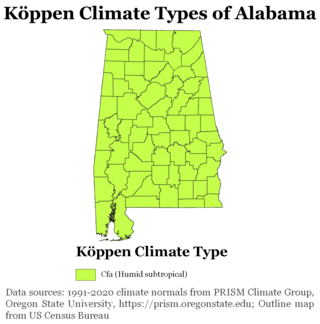
The state of Alabama is classified as humid subtropical (Cfa) under the Köppen climate classification. The state's average annual temperature is 64 °F (18 °C). Temperatures tend to be warmer in the state's southern portion with its proximity to the Gulf of Mexico, while its northern portions, especially in the Appalachian Mountains in the northeast, tend to be slightly cooler. Alabama generally has hot, humid summers and mild winters with copious precipitation throughout the year. The state receives an average of 56 inches (1,400 mm) of rainfall each year and experiences a lengthy growing season of up to 300 days in its southern portion. Hailstorms occur occasionally during the spring and summer here, but they are seldom destructive. Heavy fogs are rare, and they are confined chiefly to the coast. Thunderstorms also occur year-around. They are most common in the summer, but they are most commonly severe during the spring and late autumn. That is when destructive winds and tornadoes occur frequently, especially in the northern and central parts of the state. Central and northern Alabama are squarely within Dixie Alley, the primary area in the U.S. outside the Southern Plains with relatively high tornado risk. Alabama is ranked second in the U.S for the deadliest tornadoes. Hurricanes are quite common in the state, especially in the southern part. Major hurricanes occasionally strike the coast, such as Hurricane Frederic in September 1979 and Hurricane Ivan in September 2004; both storms resulted in significant to devastating damage in the Mobile area.
The transportation system of Alabama is a cooperation of complex systems of infrastructure.

Spring Garden is a census-designated place and unincorporated community in Cherokee County, Alabama, United States. Its population was 216 as of the 2020 census. The area was also known as Amberson or Ambersonville in the 19th century. It was erroneously called "Aubersonville" in the 1880 U.S. Census.


