
Limestone County is a county of the U.S. state of Alabama. As of the 2020 census, the county's population was 103,570. Its county seat is Athens. The county is named after Limestone Creek. Limestone County is included in the Huntsville, AL Metropolitan Statistical Area.

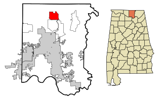
Madison County is located in the north central portion of the U.S. state of Alabama. As of the 2020 Census, the population was 388,153, making it the third-most populous county in Alabama. Its county seat is Huntsville. Since the mid-20th century it has become an area of defense and space research and industry.
Decatur is the largest city and county seat of Morgan County in the U.S. state of Alabama. Nicknamed "The River City", it is located in northern Alabama on the banks of Wheeler Lake, along the Tennessee River. The population in 2020 was 57,938.

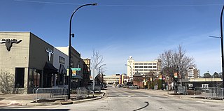
Huntsville is a city in Madison County and Limestone County, Alabama, United States, with a small portion extending into Morgan County. It is the county seat of Madison County. Located in the Appalachian region of northern Alabama, Huntsville is the most populous city in the state.

Madison is a city located primarily in Madison County, near the northern border of the U.S. state of Alabama. Madison extends west into neighboring Limestone County. The city is included in the Huntsville Metropolitan Area, the second-largest in the state, and is also included in the merged Huntsville-Decatur Combined Statistical Area. As of the 2020 census, the population of the city was 56,933, an increase over the 42,938 from the 2010 census. Madison is bordered by Huntsville on nearly all sides with some small unincorporated lands within and around Madison in Madison and Limestone counties.

Harvest is an unincorporated community and census-designated place (CDP) in the northwestern part of Madison County, Alabama, United States, and is included in the Huntsville-Decatur Combined Statistical Area. According to the 2020 U.S. Census, the population of the community is 5,893.
Hazel Green is an unincorporated community and census-designated place (CDP) in Madison County, Alabama, United States, and is included in the Huntsville-Decatur Combined Statistical Area. As of the 2020 census, the population of the community was 4,105, up from 3,630 at the 2010 census.

On May 18, 1995, a devastating F4 tornado struck near Huntsville, Alabama, killing one person and causing extensive damage and devastation, including the destruction of the Anderson Hills subdivision. The tornado touched down just northwest of Athens. It tracked from that point through eastern Limestone County, through Harvest, Meridianville, and New Market in northern Madison County, Alabama, and ended near Princeton in northwest Jackson County, Alabama. The strongest portion of the tornado's path was near Harvest in northwest Madison County around the Anderson Hills subdivision and the Huntsville Dragway, lending the tornado its name. The tornado resulted in US$5 million (1995) in property damage.

Interstate 565 (I-565) is a 22-mile-long (35 km) Interstate spur that connects I-65 in Decatur with U.S. Route 72 (US 72) in Huntsville in the US state of Alabama.

The Huntsville–Decatur, AL Combined Statistical Area is the most populated sub-region of North Alabama, and is the second fastest growing region in the State of Alabama, with 659,486 living within the CSA. It is also currently the 57th largest CSA in the country.

The Decatur, Alabama Metropolitan Statistical Area is a moderately urban region of North-Central Alabama. The 2020 Census put the population of the metropolitan area at 152,740, of which one-third resides within the boundaries of its core city, Decatur, Alabama, It is also considered to be part of the North, Northwest, and North-Central regions of Alabama.

State Route 20 (SR 20) is a 73.978-mile-long (119.056 km) state highway in the northern part of the U.S. state of Alabama. It travels from the Tennessee state line, where it continues as Tennessee State Route 69, northwest of Florence, east to Interstate 65 (I-65), east of Decatur. It crosses the Tennessee River at Florence and also at Decatur

The Huntsville Hospital Health System, also known as Huntsville Hospital, is a public, not-for-profit hospital organization consisting of several sites and buildings originating in the downtown area of Huntsville, Alabama. The Huntsville Hospital Health System has evolved and now owns or works with several other hospitals in Alabama. It has around 13,000 employees, 2,000 nurses and 650 physicians.
Monrovia, also known as Vaughn Corners or Thompson Mill, is an unincorporated community in Madison County, Alabama, United States. It is bordered on the south by the city of Madison, on the southeast by the city of Huntsville, on the west by Limestone County and on the north by the community of Harvest.

Toney is an unincorporated community in the northwestern part of Madison County, Alabama, United States. It is part of the Huntsville-Decatur Combined Statistical Area. According to "Appointment of Postmasters, 1832 - September 30, 1971" from the National Archive, the post office was established in 1898. Blanche Rawls Toney was the first post master, and Toney is said to have been named in her honor, probably by James E. Toney, her husband.

The Huntsville Metropolitan Statistical Area is a metropolitan statistical area on the northern border of Alabama. The metro area's principal city is Huntsville, and consists of two counties: Limestone and Madison. As of the 2020 United States census, the Huntsville Metropolitan Area's population was 491,723, making it the 2nd-largest metropolitan area in Alabama and the 113th-largest in the United States.
Capshaw, formerly known as Lux, is an unincorporated community in eastern Limestone County, Alabama, United States. It is located at the intersection of Capshaw, Sanderson and NW Dupree Worthey Roads. It is now mostly a part of Huntsville with the southern portion near Highway 72 being part of Madison City.
Governors Drive is a major east–west thoroughfare in Huntsville, Alabama. It follows U.S. Route 431 (US-431) in east Huntsville and State Route 53 (SR-53) in west Huntsville. Governors Drive is one of the main entrance points to the city from the east, carrying on average approximately 48,000 vehicles a day across Monte Sano Mountain.

An extensive collection of parks and greenways exists in Huntsville, Alabama for the public's recreational use.


