Grace, Idaho

Last updated
Grace, Idaho
Grace, Idaho.jpg
Caribou County Idaho Incorporated and Unincorporated areas Grace Highlighted 1632500.svg
Location of Grace in Caribou County, Idaho.
Coordinates: 42°34′34″N111°43′47″W / 42.57611°N 111.72972°W / 42.57611; -111.72972
Country United States
State Idaho
County Caribou
Area
[1]
  Total0.96 sq mi (2.48 km2)
  Land0.96 sq mi (2.48 km2)
  Water0.00 sq mi (0.00 km2)
Elevation
5,535 ft (1,687 m)
Population
 (2010) [2]
  Total915
  Estimate 
(2019) [3]
935
  Density975.99/sq mi (376.82/km2)
Time zone UTC-7 (Mountain (MST))
  Summer (DST) UTC-6 (MDT)
ZIP code
83241
Area code 208
FIPS code 16-32500
GNIS feature ID0396575

Grace is a city in Caribou County, Idaho, United States. The population was 920 at the 2020 census. [4]

Contents

History

The area of Grace was once inhabited by the Shoshone Indians. The Oregon Trail passed within 4 miles (6.4 km) of Grace and the town itself was established with a post office in 1894. [5] Unlike other nearby historic towns such as Paris and Franklin, Grace was not originally settled by Mormon pioneers, but has since become a predominantly Mormon-populated town. The economy in and around Grace has traditionally been driven by agriculture, with potatoes, alfalfa, grain, dairy and ranching being the main staples.

Geography

According to the United States Census Bureau, the city has a total area of 0.99 square miles (2.56 km2), all of it land. [6]

Grace is one of the northernmost cities along the Wasatch Range which extends approximately 160 miles (260 km) south, and is only 1 mile (1.6 km) west of the large fault line that defines the range. Grace is located near the center of Gem Valley.

In stark contrast to the surrounding mountains, the valley floor in the immediate area of Grace is flat due to volcanic activity in the area some 30,000 years ago. The lava flow that created the valley also diverted the Bear River from its Pacific drainage into the Great Basin. This was a significant contributor to the growth of the prehistoric Lake Bonneville of which the Great Salt Lake is a remnant. Lake Bonneville reached its farthest north advance about four miles (6 km) southwest of Grace before it broke through the earthen barrier at Red Rock pass north of Preston, Idaho. The Bear River today runs to the north and west of Grace and terminates in the Great Salt Lake.

Grace's neighboring towns are Soda Springs to the north east, Bancroft to the north west, and Preston to the south. It is about 20 miles (32 km) from Lava Hot Springs, which is a local tourism and recreation destination. The nearest city with a major airport is Salt Lake City, Utah, which is approximately 175 miles (282 km) south.

Climate

This climatic region is typified by large seasonal temperature differences, with warm to hot (and often humid) summers and cold (sometimes severely cold) winter. According to the Köppen Climate Classification system, Grace has a humid continental climate, abbreviated "Dfb" on climate maps. [7]

Geology

There are several extinct volcanoes and lava domes within miles of Grace, which contributes to the dark, nitrogen rich volcanic soil of the area. This soil type is ideal for farming, particularly potatoes and grain. Solid basalt can be found beneath the soil throughout most of the valley and exposed outcrops are common. Other types of rock that are common in the area are limestone and shale. These non-volcanic rock beds are rich with fossils of prehistoric marine life once native to the inland sea that covered the area some 280 million years ago, ranging from well preserved molluscan shells, to small fish. Trilobite fossils can often be found in local shale deposits. The inland sea was also responsible for the vast phosphate deposits that lie north of Grace and are a vital part of the area's economy.

The Bear River runs through Black Canyon which originates 1-mile (1.6 km) northwest of town and extends approximately 8 miles (13 km) south. Approximately one-half mile downstream from the point of origin, the Black Canyon forms a sharp gorge with steep walls of black basalt cliffs. At this point the gorge is only about 100 yards (91 m) wide and nearly 100 ft (30 m) deep.

The Wasatch Fault is visible from Grace due to the sharp displacement that creates a small bench at the foot of the mountains. Mild to moderate earthquakes have been reported to originate at the fault.

Demographics

Historical population
CensusPop.Note
1930 626
1940 70112.0%
1950 7618.6%
1960 725−4.7%
1970 82613.9%
1980 1,21647.2%
1990 973−20.0%
2000 9901.7%
2010 915−7.6%
2019 (est.)935 [3] 2.2%
U.S. Decennial Census [8]

2010 census

As of the census [2] of 2010, there were 915 people, 366 households, and 266 families residing in the city. The population density was 924.2 inhabitants per square mile (356.8/km2). There were 400 housing units at an average density of 404.0 per square mile (156.0/km2). The racial makeup of the city was 96.9% White, 0.1% African American, 0.4% Native American, 0.1% Asian, 0.1% Pacific Islander, 1.5% from other races, and 0.8% from two or more races. Hispanic or Latino of any race were 4.2% of the population.

There were 366 households, of which 33.6% had children under the age of 18 living with them, 62.0% were married couples living together, 5.7% had a female householder with no husband present, 4.9% had a male householder with no wife present, and 27.3% were non-families. 24.6% of all households were made up of individuals, and 13.7% had someone living alone who was 65 years of age or older. The average household size was 2.50 and the average family size was 3.00.

The median age in the city was 38.9 years. 26.3% of residents were under the age of 18; 6.1% were between the ages of 18 and 24; 23.3% were from 25 to 44; 25.9% were from 45 to 64; and 18.5% were 65 years of age or older. The gender makeup of the city was 52.3% male and 47.7% female.

2000 census

As of the census [9] of 2000, there were 990 people, 364 households, and 274 families residing in the city. The population density was 1,002.7 inhabitants per square mile (387.1/km2). There were 389 housing units at an average density of 394.0 per square mile (152.1/km2). The racial makeup of the city was 95.56% White, 0.20% Native American, 3.33% from other races, and 0.91% from two or more races. Hispanic or Latino of any race were 4.95% of the population.

There were 364 households, out of which 35.2% had children under the age of 18 living with them, 64.3% were married couples living together, 6.3% had a female householder with no husband present, and 24.5% were non-families. 23.4% of all households were made up of individuals, and 14.8% had someone living alone who was 65 years of age or older. The average household size was 2.72 and the average family size was 3.21.

In the city, the population was spread out, with 31.4% under the age of 18, 6.9% from 18 to 24, 23.8% from 25 to 44, 22.5% from 45 to 64, and 15.4% who were 65 years of age or older. The median age was 36 years. For every 100 females, there were 103.3 males. For every 100 females age 18 and over, there were 92.9 males.

The median income for a household in the city was $32,303, and the median income for a family was $39,306. Males had a median income of $33,214 versus $14,306 for females. The per capita income for the city was $13,452. About 5.7% of families and 7.0% of the population were below the poverty line, including 6.8% of those under age 18 and 11.7% of those age 65 or over.

Recreation

Although a small community, Grace offers an array of activities that most can enjoy. Hunting and fishing are popular among many residents of Grace, as are motorsports. There are several local canyons that are accessible during the summer by truck or ATV, and in the winter by snowmobile. The nearby Alexander Reservoir provides summertime water recreation such as boating and swimming. The local Niter Ice Cave is accessible year-round and even beginning spelunkers have little trouble exploring the cave. Grace is also home to the Caribou County Fair and Rodeo.

Education

There are 3 schools: Black Canyon Elementary School, Grace Junior High School, and Grace High School; they are all under the oversight of Grace School District #148.

Notable people

Related Research Articles

<span class="mw-page-title-main">Kuna, Idaho</span> City in Ada County, Idaho, United States

Kuna is a city in Ada County, Idaho. It is part of the Boise metropolitan area. The population was 24,011 at the time of the 2020 census.

<span class="mw-page-title-main">Star, Idaho</span> City in Idaho, United States

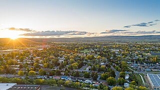
Star is a city in northwestern Ada County, Idaho, with parts stretching into neighboring Canyon County. The population was 11,117 at the 2020 census, up from 5,793 in 2010. It was named in the 19th century by travelers on their way to Middleton and Boise who used the star on the school house to find east and west. The name stuck and it became Star, Idaho. Today, it is a rapidly growing suburb of Boise and its schools are shared with Middleton School District and West Ada School District.

<span class="mw-page-title-main">Lava Hot Springs, Idaho</span> City in Bannock County, Idaho, United States

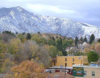
Lava Hot Springs is a city along the Portneuf River in eastern Bannock County, Idaho, United States. It is part of the Pocatello, Idaho metropolitan area. The population was 407 at the 2010 census, down from 521 in 2000. Located in the mountainous valley of the Portneuf River on the old route of the Oregon Trail and California Trail, the city has become a popular resort location, noted for its numerous hot springs amenable to bathing and a turbulent inner tube run through part of the town.

<span class="mw-page-title-main">St. Charles, Idaho</span> City in Idaho, United States

St. Charles is a city in southern Bear Lake County, Idaho, United States, that is located near the northwestern shore of Bear Lake. Its population was 131 at the 2010 census, down from 156 in 2000.

<span class="mw-page-title-main">Ammon, Idaho</span> City in Idaho, United States

Ammon is a suburb city in Bonneville County, Idaho, United States. As of the 2010 US Census, the population of Ammon was 13,816. By the 2020 census, Ammon's population had grown to 17,694. It lies directly to the east of Idaho Falls and to the west of the Ammon foothills, and is the second most populous city in the Idaho Falls metropolitan area.

<span class="mw-page-title-main">Iona, Idaho</span> City in Idaho, United States

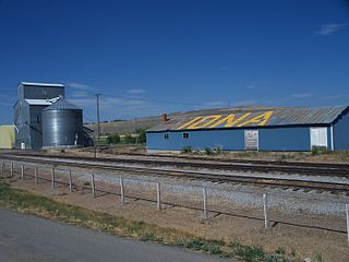
Iona is a city in Bonneville County, Idaho, United States. It is part of the Idaho Falls, Idaho Metropolitan Statistical Area. The population was 1,803 at the 2010 census.

<span class="mw-page-title-main">Swan Valley, Idaho</span> City in Idaho, United States

Swan Valley is a city in Bonneville County, Idaho, United States. It is part of the Idaho Falls, Idaho Metropolitan Statistical Area. The population was 204 at the 2010 census.

<span class="mw-page-title-main">Melba, Idaho</span> Village in Idaho, United States

Melba is a village in Canyon County, Idaho. The population was 513 at the time of the 2010 census, up from 439 in 2000. It is part of the Boise metropolitan area.

<span class="mw-page-title-main">Middleton, Idaho</span> City in Idaho, United States

Middleton is a city in Canyon County, Idaho, United States. The population amounted to 9,091 at the 2021 census estimate, up from 5,524 at the 2010 census and 2,978 in 2000. It is part of the Boise City–Nampa, Idaho Metropolitan Statistical Area.

<span class="mw-page-title-main">Notus, Idaho</span> City in Idaho, United States

Notus is a small rural city in Canyon County, Idaho. The population was 531 at the time of the 2010 census and is the smallest town out of the eight in Canyon County. It is part of the Boise metropolitan area.

<span class="mw-page-title-main">Wilder, Idaho</span> City in Idaho, United States

Wilder is a city in Canyon County, Idaho, United States. The population was 1,533 at the 2010 census.

<span class="mw-page-title-main">Riggins, Idaho</span> City in Idaho, United States

Riggins is a city in the western United States in Idaho County, Idaho. Nestled deep in a canyon at the confluence of the Salmon and Little Salmon rivers in west central Idaho, it is approximately 150 highway miles (240 km) north of Boise, and 120 highway miles (190 km) south-southeast of Lewiston. The elevation is 1,821 feet (555 m) above sea level, and its population was 419 at the 2010 census.

<span class="mw-page-title-main">Stites, Idaho</span> City in Idaho, United States

Stites is a city in Idaho County, Idaho, United States. In the lower canyon of the South Fork of the Clearwater River, it is about four miles (6 km) upstream and south of Kooskia on State Highway 13. The population was 221 at the 2010 census, down from 226 in 2000.

<span class="mw-page-title-main">Eden, Idaho</span> City in Idaho, United States

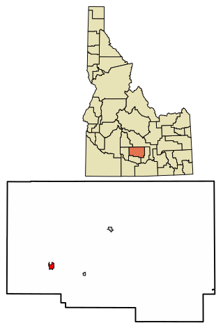
Eden is a city in Jerome County, Idaho, United States. The population was 405 at the 2010 census. It is part of the Twin Falls, Idaho Metropolitan Statistical Area.

<span class="mw-page-title-main">Leadore, Idaho</span> City in Idaho, United States

Leadore is an incorporated small town in Lemhi County, Idaho, United States. The population was 105 at the 2010 census.

<span class="mw-page-title-main">Shoshone, Idaho</span> City in Idaho, United States

Shoshone is the county seat and largest city of Lincoln County, Idaho, United States. The population was 1,461 at the 2010 census. In contrast to the Shoshone Native American tribe for which it is named, the city's name is correctly pronounced "Show-shown", with a silent "e".

<span class="mw-page-title-main">Acequia, Idaho</span> City in Idaho, United States

Acequia is a city in Minidoka County, Idaho, United States. The population was 131 at the 2020 census. It is part of the Burley, Idaho Micropolitan Statistical Area. The town is named for the Spanish word for canal.

<span class="mw-page-title-main">Marsing, Idaho</span> City in Owhyee County, Idaho, United States

Marsing is a city in Owyhee County, Idaho, United States. The population was 1,031 at the time of the 2010 census. It is part of the Boise metropolitan area.

<span class="mw-page-title-main">Fruitland, Idaho</span> City in Payette County, Idaho, United States

Fruitland is a city along the Snake and Payette rivers in Payette County, Idaho, United States. It lies along U.S. Route 95 in the Treasure Valley of southwest Idaho, about 50 miles (80 km) west of Boise on the border with Oregon. It is part of the Ontario Micropolitan Area. Fruitland is named after apple orchards that surround the community, and its slogan is "The Big Apple of Idaho."

<span class="mw-page-title-main">Canyon City, Oregon</span> City in Oregon, United States

Canyon City is a city in Grant County, Oregon, United States. It is the county seat of Grant County, and is about 2 miles (3 km) south of John Day on U.S. Highway 395. As of the 2010 census, the city had a total population of 703.

References

  1. "2019 U.S. Gazetteer Files". United States Census Bureau. Retrieved July 9, 2020.
  2. 1 2 "U.S. Census website". United States Census Bureau . Retrieved 2012-12-18.
  3. 1 2 "Population and Housing Unit Estimates". United States Census Bureau. May 24, 2020. Retrieved May 27, 2020.
  4. "Explore Census Data". data.census.gov. Retrieved 2024-05-01.
  5. Boone, Lalia (1988). Idaho Place Names: A Geographical Dictionary. Moscow, Idaho: University of Idaho Press. p. 160. ISBN   0-89301-119-3.
  6. "US Gazetteer files 2010". United States Census Bureau. Archived from the original on 2012-01-25. Retrieved 2012-12-18.
  7. Climate summary for Grace, Idaho
  8. "Census of Population and Housing". Census.gov. Retrieved June 4, 2015.
  9. "U.S. Census website". United States Census Bureau . Retrieved 2008-01-31.