Granby, South Carolina

Last updated

Granby, South Carolina
Former town
USA South Carolina location map.svg
Red pog.svg
Granby
Location in South Carolina
Usa edcp location map.svg
Red pog.svg
Granby
Location in United States
Coordinates: 33°57′54″N81°02′28″W / 33.965°N 81.041°W / 33.965; -81.041 Coordinates: 33°57′54″N81°02′28″W / 33.965°N 81.041°W / 33.965; -81.041
CountryUnited States
State South Carolina
County Lexington

Granby was the first European settlement in the area of present-day Columbia in the U.S. state of South Carolina. Settlement began around 1718 with the establishment of a trading post by the British on the Congaree River. Many small farms were settled by German, Swiss, and Scots-Irish immigrants. Granby was the largest town and county seat of Lexington County until the early 19th century, when the town began to gradually decline as Columbia, the state capital, grew. The once thriving colonial town was mostly unoccupied after the first quarter of the 19th century. Today, the area is part of present-day Cayce.

Contents

Settlement

The site was first used because it is located just downstream from the rapids and junction on the Congaree where the Broad River and Saluda River merge to form the Congaree, beyond which river transportation was difficult. Granby developed on the west shore of the Congaree. [1]

The area was also referred to as "the Congaree's lands", and later "the Congarees" after the Congaree people, who had been decimated by smallpox and conflict. The survivors moved farther inland after the Yamasee War of 1715. A 1716 agreement between the British and the Cherokee called for a trading post to be built there for the convenience of the Cherokee who otherwise traveled to Charleston. The British trading post was called Ft. Congaree [2] and existed from 1718 to 1722. [3]

The first town in the area, Saxe Gotha, was laid out in 1733 as 70 square parcels. Saxe-Gotha failed primarily due to frequent flooding, and Granby was then plotted on slightly higher ground just south in the 1750s. [4]

In 1748, a second post was built more to the east to accommodate the Catawba people, who by that time had absorbed the remaining Congaree. This post/fort became a refuge for white settlers during the Anglo-Cherokee War. [3]

Many early settlers came directly from Germany or Switzerland, or relocated from Pennsylvania (the Pennsylvania Dutch) and Virginia. The town had many successful small farms, producing corn, wheat, tobacco, hemp, flax, beeswax, and livestock. The Cherokee Indian War of 1760 and the subsequent War of the Regulation did not impede growth and prosperity of the area. [1]

The first public ferry across the river began in 1754, operated by Martin Friday (originally Fridig), an immigrant from Zürich. [3]

A trading post was founded by James Chesnut [lower-alpha 1] and Joseph Kershaw in 1765. [3] It was known as the "Congaree Store" and became one of the first important trading posts in the interior of the colony. [1] It was used to store cotton and other products to be shipped by boat to coastal towns. [6]

American Revolution

After Charleston fell to the British on May 12, 1780, the British began a campaign to take control of the entire state, and Lord Cornwallis seized the Congaree Store. It was fortified with trenches, earthworks, and a magazine, and surrounded by a timber stockade and watchtowers. Fort Granby or "the post at the Congarees" (the British name) became a British stronghold in the state and was defended by over 300 British soldiers and Hessians. [1] Cornwallis named the post after John Manners, Marquess of Granby, the Commander-in-Chief of the British army. [7]

The fort was ineffectively attacked by a small rebel force led by Brigadier General Thomas Sumter on February 19, 1781. The next day Sumter tried again with a Quaker gun and was again unsuccessful. [8] On the 21st, a superior army under the command of Lord Francis Rawdon arrived from Camden on the eastern side of the river, and Sumter abandoned the siege. Before retreating, he was able to ignite the magazine and destroy other provisions. [1]

Sumter returned in May with a six-pound cannon requisitioned from the Continental Army at Fort Motte. [6] Sumter attacked nearby Orangeburg while the main force, now led by Lt. Colonel Henry Lee III, began a siege of Fort Granby. [8] [1] The fort was under the command of Loyalist Major Andrew Maxwell, who had stored significant plunder at the fort. Upon being attacked by infantry musket fire supported by one six-pound cannon, Maxwell agreed to surrender the fort and its 352 defenders if he was allowed to keep two wagon loads of "personal loot". The captured men, including sixty German dragoons, [9] were exchanged in Charleston for Patriot prisoners of war. [10]

Post war era

After the war, Lexington County (named in honor of the Battle of Lexington) was formed in 1785 from the area previously known as Saxe-Gotha Township and Granby Township, and Granby became the capital. The county courthouse was built there. Friday's Ferry was purchased by Richard and Wade Hampton in 1785. [3] Wade Hampton replaced the ferry with an unusual river bridge built of wood and iron with an arch exceeding 100 feet (30 m), and had legislative authority to collect tolls for 100 years. [11] [3] In the early 1800s Granby was still much larger than Columbia, with a post office, large stores and other buildings of commerce. [12] It was reported in 1802 to have nearly 200 houses, twice as many as Columbia. [13]

As land upriver was cleared for cotton farming, Granby became prone to flooding, and the county seat was relocated in 1818 to Lexington. [1] Meanwhile, Columbia, on the opposite side of the river, was made South Carolina's capital in 1786, [4] spurring its growth and the further decline of Granby. Many of Granby's residents relocated to Columbia. Many of the buildings were also moved there. By 1822, the town was nearly deserted. The county courthouse was moved to Columbia, where it served as a Presbyterian church for over forty years. [12] (Another source says the building was torn down and its lumber was used to build the church.) [13]

Granby remained mostly uninhabited until the Civil War, when an earthen fortification erected there by the Confederates was attacked in the 1864 Battle of Congaree Creek. [14] Growth led to incorporation of the new and much larger town of Cayce in 1914, which included the former Granby townsite. [15] The area was resettled in 1960 when the Riverside Park area of the city of Cayce was built. [4] [14]

Archaeological project

A volunteer research project named "Finding Granby" has been active at the site in the 2010s. Over 15,000 artifacts have been unearthed. [14] [16]

Legacy

Granby Cotton Mill Granby Cotton Mill, Columbia, S.C LCCN2007662763.tif
Granby Cotton Mill

The original trading post and later fort was purchased in 1817 by the Cayce (originally Cacey) family, who used it as a residence for almost 100 years. A replica of the building now serves as the Cayce Historical Museum. [15]

A granite commemorative marker was installed at the Granby cemetery in 1929 by "The South Carolina society, Colonial Dames of America". [13] Since the cemetery is inaccessible to the public as it is surrounded by private property, the marker was moved in 2012 to the Cayce Riverwalk, a walking and jogging trail along the river. [17]

The Granby name has been given to a nearby park on the opposite side of the river in Columbia [18] and to the Granby Mill Village Historic District, also in Columbia, which includes an 1897 cotton mill and surrounding community. [19]

An archaeological site including the 1718 and 1748 trading posts was designated the Congarees and listed on the National Register of Historic Places in 1974. [20]

John Taylor, the 51st governor of South Carolina, was born on May 4, 1770, in Granby. [21]

Notes

  1. Sometimes spelled Chestnut [3] [5]

Related Research Articles

Columbia, South Carolina Capital of South Carolina

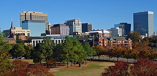
Columbia is the capital of the U.S. state of South Carolina. With a population of 136,632 as of the 2020 U.S. Census, it is the second-largest city in South Carolina. The city serves as the county seat of Richland County, and a portion of the city extends into neighboring Lexington County. It is the center of the Columbia metropolitan statistical area, which had a population of 829,470 and is the 72nd-largest metropolitan statistical area in the nation. The name Columbia is a poetic term used for the United States, derived from the name of Christopher Columbus, who explored for the Spanish Crown. Columbia is often abbreviated as Cola, leading to its nickname as "Soda City."

Cayce, South Carolina City in South Carolina, United States

Cayce is a city in the U.S. state of South Carolina, along the Congaree River. The population was 12,528 at the 2010 census. The estimated population was 14,009 in 2019, and it is the third-most populated municipality in Lexington County. The city is primarily in Lexington County, with additional, predominantly rural land to the east in Richland County. Cayce is part of the Columbia Metropolitan Statistical Area and is within South Carolina's Midlands region.

Lexington, South Carolina town in South Carolina, USA

Lexington is the largest town in and the county seat of Lexington County, South Carolina, United States. It is a suburb of the state capital, Columbia. The population was 17,870 at the 2010 Census, and it is the second-largest municipality in the greater Columbia area. The 2019 estimated population is 22,157. According to the Central Midlands Council of Governments, the greater Lexington area had an estimated population of 111,549 in 2020 and is considered the fastest-growing area in the Midlands. Lexington's town limits are bordered to the east by the city of West Columbia.

West Columbia, South Carolina City

West Columbia is a city and commuter town in the suburban eastern sections of Lexington County, South Carolina, United States. According to the 2010 census, the population was 14,988, and the 2019 population estimate was 17,998. West Columbia is bordered to the east by Columbia, the state capital, across the Congaree River. It is near Columbia's city center or downtown district as well as the South Carolina State House and the Congaree Vista, known locally as "the Vista." The city is bordered to the south by its sister suburb, Cayce. A small portion of the city borders the town of Lexington to the east. West Columbia is part of the greater Columbia, SC metropolitan statistical area.

Andrew Pickens (congressman) Revolutionary War militia general in South Carolina (1739-1817)

Andrew Pickens was a militia leader in the American Revolution. A planter, he developed his Hopewell plantation on the east side of the Keowee River across from the Cherokee town of Isunigu (Seneca) in western South Carolina. He was elected as a member of the United States House of Representatives from western South Carolina. Several treaties with the Cherokee were negotiated and signed at his plantation of Hopewell.

Congaree River River in South Carolina, United States

The Congaree River is a short but wide river in South Carolina in the United States; It flows for approximately 53 miles (85 km). The river serves an important role as the final outlet channel for the entire Lower Saluda and Lower Broad watersheds, before merging with the Wateree River just north of Lake Marion to form the Santee River.

Fort Motte United States historic place

Fort Motte was developed first as Mt. Joseph Plantation; it was commandeered in 1780 by the British and fortified as a temporary military outpost in what is now South Carolina during the American Revolutionary War. It was significant for its military use as a depot for their convoys between Camden and Charleston, which they occupied. Located along the Congaree River, it is roughly 90–95 miles from Charleston by 21st-century roadways. The British had fortified the big house and surrounds, and it became known as Fort Motte, after Rebecca Brewton Motte, who had been occupying it with her family. During the Patriot Siege of Fort Motte, the plantation mansion was set on fire. The British surrendered at this site.

Cherokee Path United States historic place

The Cherokee Path was the primary route of English and Scots traders from Charleston to Columbia, South Carolina in Colonial America. It was the way they reached Cherokee towns and territories along the upper Keowee River and its tributaries. In its lower section it was known as the Savannah River. They referred to these towns along the Keowee and Tugaloo rivers as the Lower Towns, in contrast to the Middle Towns in Western North Carolina and the Overhill Towns in present-day southeastern Tennessee west of the Appalachian Mountains.

Cheraw

The Cheraw people, also known as the Saraw or Saura, were a Siouan-speaking tribe of indigenous people of the Southeastern Woodlands, in the Piedmont area of North Carolina near the Sauratown Mountains, east of Pilot Mountain and north of the Yadkin River. They lived in villages near the Catawba River. Their first European and African contact was with the Hernando De Soto Expedition in 1540. The early explorer John Lawson included them in the larger eastern-Siouan confederacy, which he called "the Esaw Nation."

Keowee Historic Cherokee town

Keowee was a Cherokee town in the far northwest corner of present-day South Carolina. It was the principal town of what were called the seven Lower Towns, located along the Keowee River. Keowee was situated on the Lower Cherokee Traders' Path, part of the Upper Road through the Piedmont. In 1752 the Cherokee established New Keowee Town nearby, off the traders' path but in a more defensible location.

Interstate 77 (I-77) is a south–north Interstate highway, extending 91.2 miles (146.8 km) in the state of South Carolina, extending from the national southern terminus at an interchange with I-26 near Columbia, north to the North Carolina state line near Rock Hill and Charlotte, NC.

The Congaree were a group of Native Americans who lived in what is now central South Carolina of the United States, along the Congaree River. They spoke a dialect distinct from, and not intelligible by, Siouan language speakers; it is considered unclassified. This was the primary language family of Native Americans in the Piedmont, such as the Catawba. Some linguists, however, believe that the language was related to Catawban Siouan.

Interstate 26 in South Carolina Section of Interstate Highway in South Carolina, United States

Interstate 26 (I-26) is a South Carolina Interstate highway running generally east–west from near Landrum, in Spartanburg County, to U.S. Route 17, in Charleston, South Carolina. It is also the longest interstate highway in South Carolina.

Battle of Congaree Creek

The Battle of Congaree Creek was a four-hour action that took place in the waning days of the American Civil War, fought in Lexington County, South Carolina, on February 15, 1865, just south of Columbia on the site of the former town of Granby.

Emily Geiger (1765–1825) is an American Revolutionary War heroine who was captured by the British while on a military mission as a civilian. She was carrying an important message across enemy grounds when she was captured and questioned. The Tory matron could find nothing on her because Geiger had memorized the message, then eaten it, so they had to let her go. She proceeded, reached the general she had sought, and verbally delivered the message.

Brookland-Cayce High School is a public high school located in Cayce, South Carolina, United States that was built in 1932. Named for the cities of Brookland and Cayce of which it originally served, the school now serves parts of West Columbia, Cayce, South Congaree, Pine Ridge, and Gaston. It is a part of the Lexington County School District Two. Brookland-Cayce is known for its historical value as it has graduated over 85 graduating classes. When the high school first opened it was a segregated school. Brookland was a school for whites and Cayce was a school for whites. Over the years the schools joined together.

The Congarees is a historic archaeological site located near Cayce, Lexington County, South Carolina. The site was established as early as 1691, and served as a frontier outpost, early township settlement, and crossroads of the great trade paths of the Catawba and Cherokee nations. The Fort Congaree back country fort was established on the site in 1718.

South Carolina Highway 35

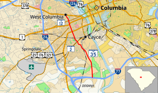
South Carolina Highway 35 (SC 35) is a 5.630-mile-long (9.061 km) state highway in the U.S. state of South Carolina. The highway connects the southern part of Cayce and West Columbia.

South Carolina Highway 302 (SC 302) is an 66.200-mile-long (106.539 km) state highway in the U.S. state of South Carolina. The highway travels through mostly rural areas of Aiken and Lexington counties and connects the Aiken with the Columbia metropolitan areas, via Wagener and Pelion.

Olympia, South Carolina Census-designated place in South Carolina, United States

Olympia is an urban unincorporated area and census-designated place (CDP) in Richland County, South Carolina, United States. It was first listed as a CDP prior to the 2020 census.

References

  1. 1 2 3 4 5 6 7 "A History of Granby, South Carolina". carolana.com. Retrieved March 28, 2017.
  2. Holleman, Joey (November 9, 2010). "Historian's work near riverfront adds new layers to the area's pre-Revolutionary War past". The State. Columbia, South Carolina. p. 1.
  3. 1 2 3 4 5 6 7 "Grandy on the Congaree". The Index-Journal. Greenwood, South Carolina. January 24, 1988. p. 18. Retrieved September 17, 2018 via Newspapers.com. Lock-green.svg
  4. 1 2 3 Mooney, James (1894). The Siouan Tribes of the East : James Mooney . Retrieved March 27, 2017.
  5. Kathryn F. Keenan (2016). In Search of Granby: a Colonial Village of South Carolina (PDF). University of South Carolina. p. 25. Retrieved August 30, 2018.
  6. 1 2 Harriette Kershaw Leiding (1921). Historic Houses of South Carolina. J.B. Lippincott. p. 251. ISBN   9780722245705 . Retrieved September 16, 2018.
  7. The Public Schools of Columbia, South Carolina: Report of a Survey Made Under the Direction of the Commissioner of Education. U.S. Government Printing Office. 1918. p. 12. Retrieved September 16, 2018.
  8. 1 2 Spencer C. Tucker (September 30, 2018). American Revolution: The Definitive Encyclopedia and Document Collection [5 volumes]. ABC-CLIO. p. 539. ISBN   978-1-85109-744-9 . Retrieved September 16, 2018.
  9. Gale, Thomas. "Fort Granby, South Carolina". encyclopedia.com. Retrieved September 16, 2018.
  10. "This Day in History, May 15, 1781 Continentals capture Fort Granby, South Carolina". history.com. Retrieved September 15, 2018.
  11. Jedidiah Morse (1804). The American Gazetteer: Exhibiting a Full Account of the Civil Divisions, Rivers, Harbours, Indian Tribes, &c. of the American Continent, Also of the West India and Other Appendant Islands; with a Particular Description of Louisiana. Samuel Etheridge, and for Thomas and Andrews, Boston. p. 141. Retrieved September 16, 2018.
  12. 1 2 Claudette Holliday (August 29, 2008). Remembering Lexington, South Carolina: Good Stewards in a New Land. Arcadia Publishing Incorporated. p. 31. ISBN   978-1-62584-881-9 . Retrieved September 16, 2018.
  13. 1 2 3 "Historical Society to Mark Renowned Town of Granby". The Greenville News. Greenville, South Carolina. September 20, 1928. p. 9. Retrieved September 17, 2018 via Newspapers.com. Lock-green.svg
  14. 1 2 3 "Finding Granby". historysoft.com. Retrieved September 16, 2018.
  15. 1 2 "The Cayce Museum". cityofcayce-sc.gov. Retrieved September 16, 2018.
  16. "Stories in the dirt: Finding Granby". WISTV.com. June 25, 2014. Retrieved September 16, 2018.
  17. "1929 Granby marker moved to riverwalk". The State. March 13, 2012. Retrieved March 28, 2017.
  18. "Granby Park". SCGreatOutdoors.com. Retrieved September 16, 2018.
  19. "National Register Information System  (#93000905)". National Register of Historic Places . National Park Service. July 9, 2010.
  20. "National Register Information System  (#74002261)". National Register of Historic Places . National Park Service. July 9, 2010.
  21. Nancy Capace (January 1, 2000). Encyclopedia of South Carolina. Somerset Publishers, Inc. pp. 1–. ISBN   978-0-403-09347-2 . Retrieved September 16, 2018.