Red Bank, South Carolina

Last updated

Red Bank, South Carolina
SCMap-doton-RedBank.PNG
Location of Red Bank, South Carolina
Coordinates: 33°55′55″N81°13′49″W / 33.93194°N 81.23028°W / 33.93194; -81.23028
Country United States
State South Carolina
County Lexington
Government
  TypeNone
Area
[1]
  Total12.76 sq mi (33.05 km2)
  Land12.54 sq mi (32.47 km2)
  Water0.22 sq mi (0.58 km2)
Elevation
[2]
341 ft (104 m)
Population
 (2020) [3]
  Total10,924
  Density871.34/sq mi (336.44/km2)
Time zone UTC-5 (Eastern (EST))
  Summer (DST) UTC-4 (EDT)
ZIP code
29073
Area code(s) 803, 839
FIPS code 45-59110 [4]
GNIS feature ID1250298 [2]

Red Bank is an unincorporated community and census-designated place (CDP) in Lexington County, South Carolina, United States. The population was 9,617 at the 2010 census, [5] up from 8,811 at the 2000 census. It is part of the Columbia, South Carolina Metropolitan Statistical Area.

Contents

Geography

Red Bank is located just east of the center of Lexington County at 33°55′55″N81°13′49″W / 33.93194°N 81.23028°W / 33.93194; -81.23028 (33.932005, -81.230211). [6] It is bordered to the north by Lexington, the county seat, and to the south by the White Knoll CDP. South Carolina Highway 6 (S. Lake Drive) is the main road through town, leading north 3.5 miles (5.6 km) to the center of Lexington and south 5.5 miles (8.9 km) to Edmund. Platt Springs Road (South Carolina Highway 602 east of SC-6) forms the border between Red Bank and White Knoll. Highway 602 leads northeast 11 miles (18 km) to West Columbia.

According to the United States Census Bureau, the Red Bank CDP has a total area of 12.0 square miles (31.2 km2), of which 11.8 square miles (30.6 km2) are land and 0.2 square miles (0.6 km2), or 1.85%, are water. [7] Red Bank Creek, an east-flowing tributary of Congaree Creek and part of the Congaree River watershed, passes just south of the original town center. Crystal Lake and Saxe-Gotha Millpond are two small reservoirs impounding the creek.

Demographics

Historical population
CensusPop.Note
2020 10,924
U.S. Decennial Census [8]

2020 census

Red Bank racial composition [9]
RaceNum.Perc.
White (non-Hispanic)7,95672.83%
Black or African American (non-Hispanic)1,51213.84%
Native American 440.4%
Asian 720.66%
Pacific Islander 40.04%
Other/Mixed 6465.91%
Hispanic or Latino 6906.32%

As of the 2020 United States census, there were 10,924 people, 4,137 households, and 3,035 families residing in the CDP.

2000 census

As of the census [4] of 2000, there were 8,811 people, 3,281 households, and 2,480 families residing in the CDP. The population density was 740.6 inhabitants per square mile (285.9/km2). There were 3,498 housing units at an average density of 294.0 per square mile (113.5/km2). The racial makeup of the CDP was 88.74% White, 8.84% African American, 0.35% Native American, 0.49% Asian, 0.03% Pacific Islander, 0.93% from other races, and 0.61% from two or more races. Hispanic or Latino of any race were 1.90% of the population.

There were 3,281 households, out of which 43.4% had children under the age of 18 living with them, 58.6% were married couples living together, 12.8% had a female householder with no husband present, and 24.4% were non-families. 19.4% of all households were made up of individuals, and 3.6% had someone living alone who was 65 years of age or older. The average household size was 2.68 and the average family size was 3.09.

In the CDP, the population was spread out, with 29.8% under the age of 18, 7.6% from 18 to 24, 37.2% from 25 to 44, 20.3% from 45 to 64, and 5.1% who were 65 years of age or older. The median age was 32 years. For every 100 females, there were 93.1 males. For every 100 females age 18 and over, there were 92.6 males.

The median income for a household in the CDP was $42,072, and the median income for a family was $50,838. Males had a median income of $36,347 versus $26,016 for females. The per capita income for the CDP was $18,664. About 5.8% of families and 7.9% of the population were below the poverty line, including 11.1% of those under age 18 and 7.2% of those age 65 or over.

Related Research Articles

<span class="mw-page-title-main">Orangeburg County, South Carolina</span> County in South Carolina, United States

Orangeburg County is a county located in the U.S. state of South Carolina. As of the 2020 census, the population was 84,223. Its county seat is Orangeburg. The county was created in 1769.

<span class="mw-page-title-main">Lexington County, South Carolina</span> County in South Carolina, United States

Lexington County is a county located in the U.S. state of South Carolina. As of the 2020 census, the population was 293,991. Its county seat and largest town is Lexington. The county was chartered in 1785 and was named in commemoration of Lexington, Massachusetts, the site of the Battle of Lexington in the American Revolutionary War. Lexington County is the sixth-largest county in South Carolina by population and is part of the Columbia, SC Metropolitan Statistical Area. It is located in the Midlands region of South Carolina.

<span class="mw-page-title-main">Calhoun County, South Carolina</span> County in South Carolina, United States

Calhoun County is a county in the U.S. state of South Carolina. As of the 2020 census, its population was 14,119, making it the third-least populous county in the state. Its county seat is St. Matthews. In terms of land area, it is also the smallest county in the state.

<span class="mw-page-title-main">Crown Heights, New York</span> Census-designated place in New York, United States

Crown Heights is a hamlet and census-designated place (CDP) in Dutchess County, New York, United States. The population was 2,840 at the 2010 census. It is part of the Poughkeepsie–Newburgh–Middletown, NY Metropolitan Statistical Area as well as the larger New York–Newark–Bridgeport, NY-NJ-CT-PA Combined Statistical Area.

<span class="mw-page-title-main">West Hill, Ohio</span> Census-designated place in Ohio, United States

West Hill is an unincorporated community and census-designated place in eastern Brookfield Township, Trumbull County, Ohio, United States. The population was 2,218 at the 2020 census. It is part of the Youngstown–Warren metropolitan area.

<span class="mw-page-title-main">Olanta, South Carolina</span> Town in South Carolina, United States

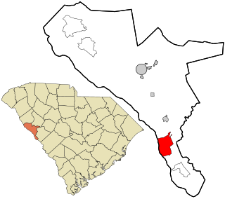
Olanta is a town in Florence County, South Carolina, United States. The population was 563 at the 2010 census, down from 613 in 2000. It is part of the Florence Metropolitan Statistical Area.

Five Forks is a census-designated place (CDP) in Greenville County, South Carolina, United States. The population was 17,737 at the 2020 census, up from 14,140 in 2010, and 8,064 in 2000. It is a growing, affluent suburb of Greenville and is part of the Greenville–Mauldin–Easley Metropolitan Statistical Area.

<span class="mw-page-title-main">Red Hill, South Carolina</span> Census-designated place in South Carolina, United States

Red Hill is a census-designated place (CDP) in Horry County, South Carolina, United States. The population was 13,223 at the 2010 census, up from 10,509 at the 2000 census.

<span class="mw-page-title-main">Cayce, South Carolina</span> City in South Carolina, United States

Cayce is a city in the U.S. state of South Carolina, along the Congaree River. The population was 12,528 at the 2010 census and rose to 13,789 in the 2020 United States Census, and it is the third-most populated municipality in Lexington County. The city is primarily in Lexington County, with additional, predominantly rural land to the east in Richland County. Cayce is part of the Columbia Metropolitan Statistical Area and is within South Carolina's Midlands region.

<span class="mw-page-title-main">Gaston, South Carolina</span> Town in South Carolina, United States

Gaston is a town in Lexington County, South Carolina, United States. The population was 1,645 at the 2010 census. It is part of the Columbia, South Carolina Metropolitan Statistical Area.

<span class="mw-page-title-main">Oak Grove, South Carolina</span> Census-designated place in South Carolina, United States

Oak Grove is a census-designated place (CDP) in Lexington County, South Carolina, United States. The population was 10,291 at the 2010 census. It is part of the Columbia Metropolitan Statistical Area.

Seven Oaks is a census-designated place (CDP) in Lexington County, South Carolina, United States, 8 miles (13 km) northwest of downtown Columbia, the state capital. The population of the CDP was 15,144 at the 2010 census. It is part of the Columbia Metropolitan Statistical Area.

<span class="mw-page-title-main">South Congaree, South Carolina</span> Town in South Carolina, United States

South Congaree is a town in Lexington County, South Carolina, United States. The population was 2,306 at the 2010 census. It is part of the Columbia, South Carolina Metropolitan Statistical Area.

<span class="mw-page-title-main">West Columbia, South Carolina</span> City in South Carolina, United States

West Columbia, formerly Brookland, is a city and commuter town in the suburban eastern sections of Lexington County, South Carolina, United States. According to the 2010 census, the population was 14,988, and the 2019 population estimate was 17,998. West Columbia is bordered to the east by Columbia, the state capital, across the Congaree River. It is near Columbia's city center or downtown district as well as the South Carolina State House and the Congaree Vista, known locally as "the Vista." The city is bordered to the south by its sister suburb, Cayce. A small portion of the city borders the town of Lexington to the east. West Columbia is part of the greater Columbia, SC metropolitan statistical area.

<span class="mw-page-title-main">Modoc, South Carolina</span> CDP in South Carolina, United States

Modoc is a census-designated place (CDP) in McCormick County, South Carolina, United States. The population was 256 at the 2000 census, and 218 at the 2010 census, a decline of 14.8%.

<span class="mw-page-title-main">Dentsville, South Carolina</span> Census-designated place in South Carolina, United States

Dentsville is a census-designated place (CDP) in Richland County, South Carolina, United States. The population was 14,062 at the 2010 census. It is part of the Columbia, South Carolina, Metropolitan Statistical Area.

Stateburg is a census-designated place (CDP) in the High Hills of Santee in Sumter County, South Carolina, United States. The population was 1,380 at the 2010 census. It is included in the Sumter, South Carolina Metropolitan Statistical Area. Stateburg is located within the larger Stateburg Historic District.

<span class="mw-page-title-main">Lake McMurray, Washington</span> CDP in Washington, United States

Lake McMurray is a census-designated place (CDP) in Skagit County, Washington, United States. The population was 192 at the 2010 census. It is included in the Mount Vernon–Anacortes, Washington Metropolitan Statistical Area.

<span class="mw-page-title-main">Wilton (CDP), Maine</span> Census-designated place in Maine, United States

Wilton is a census-designated place (CDP) consisting of the main settlement within the town of Wilton in Franklin County, Maine, United States. The CDP population was 2,198 at the 2010 census, out of a total town population of 4,116.

Topsham is a census-designated place (CDP) in the town of Topsham in Sagadahoc County, Maine, United States. The population was 6,271 at the 2000 census. It is part of the Portland–South Portland–Biddeford, Maine Metropolitan Statistical Area.

References

  1. "ArcGIS REST Services Directory". United States Census Bureau. Retrieved October 15, 2022.
  2. 1 2 U.S. Geological Survey Geographic Names Information System: Red Bank, South Carolina
  3. "Census Population API". United States Census Bureau. Retrieved October 15, 2022.
  4. 1 2 "U.S. Census website". United States Census Bureau . Retrieved January 31, 2008.
  5. "Total Population: 2010 Census DEC Summary File 1 (P1), Red Bank CDP, South Carolina". data.census.gov. U.S. Census Bureau. Retrieved December 29, 2020.
  6. "US Gazetteer files: 2010, 2000, and 1990". United States Census Bureau. February 12, 2011. Retrieved April 23, 2011.
  7. "2019 U.S. Gazetteer Files". United States Census Bureau. Retrieved December 29, 2020.
  8. "Census of Population and Housing". Census.gov. Retrieved June 4, 2016.
  9. "Explore Census Data". data.census.gov. Retrieved December 14, 2021.