Pelion, South Carolina

Last updated

Pelion, South Carolina
SCMap-doton-Pelion.PNG
Coordinates: 33°45′56″N81°14′47″W / 33.76556°N 81.24639°W / 33.76556; -81.24639
Country United States
State South Carolina
County Lexington
Incorporated1912
Area
[1]
  Total3.77 sq mi (9.77 km2)
  Land3.68 sq mi (9.54 km2)
  Water0.09 sq mi (0.23 km2)
Elevation
[2]
387 ft (118 m)
Population
 (2020) [3]
  Total631
  Density171.37/sq mi (66.18/km2)
Time zone UTC-5 (EST)
  Summer (DST) UTC-4 (EDT)
ZIP code
29123
Area code(s) 803, 839
FIPS code 45-55420 [4]
GNIS feature ID1250054 [2]

Pelion is a town in Lexington County, South Carolina, United States. The population was 674 at the 2010 census. It is part of the Columbia, South Carolina Metropolitan Statistical Area.

Contents

History

A post office called Pelion has been in operation since 1900. [5] The town was named after Mt Pelion in Greece. [6]

Geography

Pelion is located at 33°45′56″N81°14′47″W / 33.76556°N 81.24639°W / 33.76556; -81.24639 (33.765562, -81.246472). [7]

According to the United States Census Bureau, the town has a total area of 3.6 square miles (9.2 km2), of which 3.5 square miles (9.0 km2) is land and 0.1 square mile (0.3 km2) (2.81%) is water.

Demographics

Historical population
CensusPop.Note
1920 184
1930 2008.7%
1940 2126.0%
1950 196−7.5%
1960 23318.9%
1970 216−7.3%
1980 213−1.4%
1990 33657.7%
2000 55364.6%
2010 67421.9%
2020 631−6.4%
U.S. Decennial Census [8] [3]

As of the census [4] of 2000, there were 553 people, 192 households, and 147 families residing in the town. The population density was 159.7 inhabitants per square mile (61.7/km2). There were 211 housing units at an average density of 60.9 per square mile (23.5/km2). The racial makeup of the town was 96.75% White, 0.72% African American, 0.18% Native American, 0.90% Asian, 0.54% from other races, and 0.90% from two or more races. Hispanic or Latino of any race were 2.17% of the population.

There were 192 households, out of which 42.2% included children under the age of 18 living with them, 66.1% were married couples living together, 7.8% had a female householder with no husband present, and 23.4% were non-families. 20.3% of all households were made up of individuals, and 9.4% had someone living alone who was 65 years of age or older. The average household size was 2.69 and the average family size was 3.14.

In the town, the population was spread out, with 27.5% under the age of 18, 8.3% from 18 to 24, 28.8% from 25 to 44, 21.9% from 45 to 64, and 13.6% who were 65 years of age or older. The median age was 35 years. For every 100 females, there were 84.9 males. For every 100 females age 18 and over, there were 81.4 males.

The median income for a household in the town was $42,222, and the median income for a family was $47,917. Males had a median income of $31,696 versus $25,769 for females. The per capita income for the town was $14,838. About 6.1% of families and 12.1% of the population were below the poverty line, including 7.9% of those under age 18 and 17.5% of those age 65 or over.

Education

Pelion has a public library, a branch of the Lexington County Public Library. [9]

Pelion also has 4 schools, Pelion High School, Pelion Middle School, Pelion Elementary School, and Forts Pond Elementary School.

Notable people

Related Research Articles

<span class="mw-page-title-main">Tahoe Vista, California</span> Census-designated place in California, United States

Tahoe Vista is a census-designated place located on the north shore of Lake Tahoe in Placer County, California. It is part of the Sacramento–Arden-Arcade–Roseville Metropolitan Statistical Area. The population was 1,433 at the 2010 census, down from 1,668 at the 2000 census.

<span class="mw-page-title-main">Crescent Beach, St. Johns County, Florida</span> CDP in Florida, United States

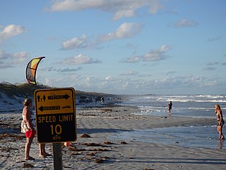
Crescent Beach is an unincorporated census-designated place in St. Johns County, Florida, United States. The population was 844 at the 2020 census, down from 931 at the 2010 census. It is part of the Jacksonville, Florida Metropolitan Statistical Area.

<span class="mw-page-title-main">Lexington, Georgia</span> City in Georgia, United States

The city of Lexington is the county seat of Oglethorpe County, Georgia, United States. The population was 239 at the 2000 census.

<span class="mw-page-title-main">West Yarmouth, Massachusetts</span> Census-designated place in Massachusetts, United States

West Yarmouth is a census-designated place (CDP) in the town of Yarmouth in Barnstable County, Massachusetts, United States. The population was 6,012 at the 2010 census.

<span class="mw-page-title-main">Hop Bottom, Pennsylvania</span> Borough in Pennsylvania, United States

Hop Bottom is a borough of Susquehanna County, Pennsylvania, United States. The population was 310 as of the 2020 census. The name comes from the hop, a plant providing flowers for brewing.

<span class="mw-page-title-main">Hilda, South Carolina</span> Town in South Carolina, United States

Hilda is a town in Barnwell County, South Carolina, United States. The population was 447 at the 2010 census..

<span class="mw-page-title-main">Kline, South Carolina</span> Town in South Carolina, United States

Kline is a town in Barnwell County, South Carolina, United States. The population was 197 at the 2010 census.

<span class="mw-page-title-main">Snelling, South Carolina</span> Town in South Carolina, United States

Snelling is a town in Barnwell County, South Carolina, United States. The population was 274 at the 2010 census.

<span class="mw-page-title-main">Williston, South Carolina</span> Town in South Carolina, United States

Williston is a town in Barnwell County, South Carolina, United States. The population was 3,139 at the 2010 census.

<span class="mw-page-title-main">Hodges, South Carolina</span> Town in South Carolina, United States

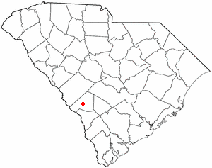
Hodges is a town in Greenwood County, South Carolina, United States. The population was 155 at the 2010 census. The mayor is Michael George.

<span class="mw-page-title-main">Gilbert, South Carolina</span> Town in South Carolina, United States

Gilbert is a town in Lexington County, South Carolina, United States. The population was 569 at the 2010 census. It is part of the Columbia, South Carolina Metropolitan Statistical Area.

<span class="mw-page-title-main">Oak Grove, South Carolina</span> Census-designated place in South Carolina, United States

Oak Grove is a census-designated place (CDP) in Lexington County, South Carolina, United States. The population was 10,291 at the 2010 census. It is part of the Columbia Metropolitan Statistical Area.

Pine Ridge is a town in Lexington County, South Carolina, United States. The population was 2,064 at the 2010 census. It is part of the Columbia, South Carolina Metropolitan Statistical Area.

<span class="mw-page-title-main">Red Bank, South Carolina</span> Census-designated place in South Carolina, United States

Red Bank is an unincorporated community and census-designated place (CDP) in Lexington County, South Carolina, United States. The population was 9,617 at the 2010 census, up from 8,811 at the 2000 census. It is part of the Columbia, South Carolina Metropolitan Statistical Area.

Seven Oaks is a census-designated place (CDP) in Lexington County, South Carolina, United States, 8 miles (13 km) northwest of downtown Columbia, the state capital. The population of the CDP was 15,144 at the 2010 census. It is part of the Columbia Metropolitan Statistical Area.

<span class="mw-page-title-main">South Congaree, South Carolina</span> Town in South Carolina, United States

South Congaree is a town in Lexington County, South Carolina, United States. The population was 2,306 at the 2010 census. It is part of the Columbia, South Carolina Metropolitan Statistical Area.

Springdale is a town in Lexington County, South Carolina, United States. The population was 2,636 at the 2010 census. It is part of the Columbia Metropolitan Statistical Area.

<span class="mw-page-title-main">Summit, South Carolina</span> Town in South Carolina, United States

Summit is a town in Lexington County, South Carolina, United States. The population was 402 at the 2010 census. It is part of the Columbia, South Carolina Metropolitan Statistical Area.

<span class="mw-page-title-main">Swansea, South Carolina</span> Town in South Carolina, United States

Swansea is a town in Lexington County, South Carolina, United States. The population was 827 at the 2010 census. It is part of the Columbia, South Carolina Metropolitan Statistical Area.

<span class="mw-page-title-main">Bancroft, West Virginia</span> Town in West Virginia, United States

Bancroft is a town in Putnam County, West Virginia, United States, along the Kanawha River. The population was 389 at the 2020 census. It is part of the Huntington–Ashland metropolitan area.

References

  1. "ArcGIS REST Services Directory". United States Census Bureau. Retrieved October 15, 2022.
  2. 1 2 U.S. Geological Survey Geographic Names Information System: Pelion, South Carolina
  3. 1 2 "Census Population API". United States Census Bureau. Retrieved October 15, 2022.
  4. 1 2 "U.S. Census website". United States Census Bureau . Retrieved January 31, 2008.
  5. "Lexington County". Jim Forte Postal History. Retrieved October 28, 2015.
  6. Boman, Roberta A. (August 20, 1981). "Railroad gave towns names". The Sumter Daily Item. pp. 6B. Retrieved October 28, 2015.
  7. "US Gazetteer files: 2010, 2000, and 1990". United States Census Bureau. February 12, 2011. Retrieved April 23, 2011.
  8. "Census of Population and Housing". Census.gov. Retrieved June 4, 2015.
  9. "Locations". Lexington County Public Library. Retrieved September 28, 2022.