
Global Warming Potential (GWP) is an index to measure of how much infrared thermal radiation a greenhouse gas would absorb over a given time frame after it has been added to the atmosphere. The GWP makes different greenhouse gases comparable with regards to their "effectiveness in causing radiative forcing". It is expressed as a multiple of the radiation that would be absorbed by the same mass of added carbon dioxide, which is taken as a reference gas. Therefore, the GWP is one for CO2. For other gases it depends on how strongly the gas absorbs infrared thermal radiation, how quickly the gas leaves the atmosphere, and the time frame being considered.

Satellite temperature measurements are inferences of the temperature of the atmosphere at various altitudes as well as sea and land surface temperatures obtained from radiometric measurements by satellites. These measurements can be used to locate weather fronts, monitor the El Niño-Southern Oscillation, determine the strength of tropical cyclones, study urban heat islands and monitor the global climate. Wildfires, volcanos, and industrial hot spots can also be found via thermal imaging from weather satellites.

The Upper Atmosphere Research Satellite (UARS) was a NASA-operated orbital observatory whose mission was to study the Earth's atmosphere, particularly the protective ozone layer. The 5,900-kilogram (13,000 lb) satellite was deployed from Space Shuttle Discovery during the STS-48 mission on 15 September 1991. It entered Earth orbit at an operational altitude of 600 kilometers (370 mi), with an orbital inclination of 57 degrees.
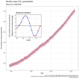
The Keeling Curve is a graph of the accumulation of carbon dioxide in the Earth's atmosphere based on continuous measurements taken at the Mauna Loa Observatory on the island of Hawaii from 1958 to the present day. The curve is named for the scientist Charles David Keeling, who started the monitoring program and supervised it until his death in 2005.
Trace gases are gases that are present in small amounts within an environment such as a planet's atmosphere. Trace gases in Earth's atmosphere are gases other than nitrogen (78.1%), oxygen (20.9%), and argon (0.934%) which, in combination, make up 99.934% of its atmosphere.
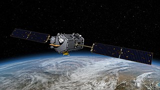
The Orbiting Carbon Observatory (OCO) is a NASA satellite mission intended to provide global space-based observations of atmospheric carbon dioxide. The original spacecraft was lost in a launch failure on 24 February 2009, when the payload fairing of the Taurus rocket which was carrying it failed to separate during ascent. The added mass of the fairing prevented the satellite from reaching orbit. It subsequently re-entered the atmosphere and crashed into the Indian Ocean near Antarctica. The replacement satellite, Orbiting Carbon Observatory-2, was launched 2 July 2014 aboard a Delta II rocket. The Orbiting Carbon Observatory-3, a stand-alone payload built from the spare OCO-2 flight instrument, was installed on the International Space Station's Kibō Exposed Facility in May 2019.

In climate science, longwave radiation (LWR) is electromagnetic thermal radiation emitted by Earth's surface, atmosphere, and clouds. It may also be referred to as terrestrial radiation. This radiation is in the infrared portion of the spectrum, but is distinct from the shortwave (SW) near-infrared radiation found in sunlight.
The atmospheric infrared sounder (AIRS) is one of six instruments flying on board NASA's Aqua satellite, launched on May 4, 2002. The instrument is designed to support climate research and improve weather forecasting.
Carbon monitoring as part of greenhouse gas monitoring refers to tracking how much carbon dioxide or methane is produced by a particular activity at a particular time. For example, it may refer to tracking methane emissions from agriculture, or carbon dioxide emissions from land use changes, such as deforestation, or from burning fossil fuels, whether in a power plant, automobile, or other device. Because carbon dioxide is the greenhouse gas emitted in the largest quantities, and methane is an even more potent greenhouse gas, monitoring carbon emissions is widely seen as crucial to any effort to reduce emissions and thereby slow climate change.

Greenhouse Gases Observing Satellite (GOSAT), also known as Ibuki, is an Earth observation satellite and the world's first satellite dedicated to greenhouse gas monitoring. It measures the densities of carbon dioxide and methane from 56,000 locations on the Earth's atmosphere. The GOSAT was developed by the Japan Aerospace Exploration Agency (JAXA) and launched on 23 January 2009, from the Tanegashima Space Center. Japan's Ministry of the Environment, and the National Institute for Environmental Studies (NIES) use the data to track gases causing the greenhouse effect, and share the data with NASA and other international scientific organizations.
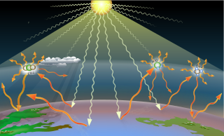
Greenhouse gases (GHGs) are the gases in the atmosphere that raise the surface temperature of planets such as the Earth. What distinguishes them from other gases is that they absorb the wavelengths of radiation that a planet emits, resulting in the greenhouse effect. The Earth is warmed by sunlight, causing its surface to radiate heat, which is then mostly absorbed by greenhouse gases. Without greenhouse gases in the atmosphere, the average temperature of Earth's surface would be about −18 °C (0 °F), rather than the present average of 15 °C (59 °F).
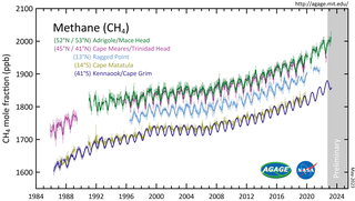
Atmospheric methane is the methane present in Earth's atmosphere. The concentration of atmospheric methane is increasing due to methane emissions, and is causing climate change. Methane is one of the most potent greenhouse gases. Methane's radiative forcing (RF) of climate is direct, and it is the second largest contributor to human-caused climate forcing in the historical period. Methane is a major source of water vapour in the stratosphere through oxidation; and water vapour adds about 15% to methane's radiative forcing effect. The global warming potential (GWP) for methane is about 84 in terms of its impact over a 20-year timeframe, and 28 in terms of its impact over a 100-year timeframe.
Paul O. Wennberg is the R. Stanton Avery Professor of Atmospheric Chemistry and Environmental Science and Engineering at the California Institute of Technology (Caltech). He is the director of the Ronald and Maxine Linde Center for Global Environmental Science. He is chair of the Total Carbon Column Observing Network and a founding member of the Orbiting Carbon Observatory project, which created NASA's first spacecraft for analysis of carbon dioxide in the atmosphere. He is also the principal investigator for the Mars Atmospheric Trace Molecule Occultation Spectrometer (MATMOS) to investigate trace gases in Mars's atmosphere.

ADEOS I was an Earth observation satellite launched by NASDA in 1996. The mission's Japanese name, Midori means "green". The mission ended in July 1997 after the satellite sustained structural damage to the solar panel. Its successor, ADEOS II, was launched in 2002. Like the first mission, it ended after less than a year, also following solar panel malfunctions.
The Total Carbon Column Observing Network (TCCON) is a global network of instruments that measure the amount of carbon dioxide, methane, carbon monoxide, nitrous oxide and other trace gases in the Earth's atmosphere. The TCCON began in 2004 with the installation of the first instrument in Park Falls, Wisconsin, USA, and has since grown to 23 operational instruments worldwide, with 7 former sites.
TanSat, also known as CarbonSat, is a Chinese Earth observation satellite dedicated to monitoring carbon dioxide in Earth's atmosphere. It is generally classified as a minisatellite, and is the first dedicated carbon mission of the Chinese space program. The mission was formally proposed in 2010, and work began in January 2011. It is funded by the Ministry of Science and Technology (MOST) and was built by the Shanghai Institute of Microsystem And Information Technology (SIMIT).
Space-based measurements of carbon dioxide are used to help answer questions about Earth's carbon cycle. There are a variety of active and planned instruments for measuring carbon dioxide in Earth's atmosphere from space. The first satellite mission designed to measure CO2 was the Interferometric Monitor for Greenhouse Gases (IMG) on board the ADEOS I satellite in 1996. This mission lasted less than a year. Since then, additional space-based measurements have begun, including those from two high-precision satellites. Different instrument designs may reflect different primary missions.
Increasing methane emissions are a major contributor to the rising concentration of greenhouse gases in Earth's atmosphere, and are responsible for up to one-third of near-term global heating. During 2019, about 60% of methane released globally was from human activities, while natural sources contributed about 40%. Reducing methane emissions by capturing and utilizing the gas can produce simultaneous environmental and economic benefits.

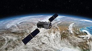
The Orbiting Carbon Observatory-3 (OCO-3) is a NASA-JPL instrument designed to measure carbon dioxide in Earth's atmosphere. The instrument is mounted on the Japanese Experiment Module-Exposed Facility on board the International Space Station (ISS). OCO-3 was scheduled to be transported to space by a SpaceX Dragon from a Falcon 9 rocket on 30 April 2019, but the launch was delayed to 3 May, due to problems with the space station's electrical power system. This launch was further delayed to 4 May due to electrical issues aboard Of Course I Still Love You (OCISLY), the barge used to recover the Falcon 9’s first stage. OCO-3 was launched as part of CRS-17 on 4 May 2019 at 06:48 UTC. The nominal mission lifetime is ten years.
Mace Head Atmospheric Research Station is located on the West Coast of Ireland in Carna, and is one of the longest running mercury recording stations in the world. The stations location is highly important as it is far away from neighbouring cities to ensure no pollutants interfere with recordings, and its location is also highly important as it is ideal for studying the atmosphere under Northern Hemispheric and European conditions. The station has the dual status of being a World Meteorological Organization (WMO) Global Atmosphere Watch (GMO) station and a European Monitoring and Evaluation Program (EMEP) supersite. Mace Head research and monitor the climate and atmospheric composition, focusing on aerosol-cloud interactions and mercury readings.
