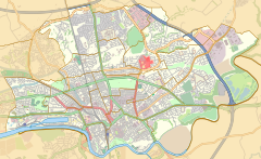
Moor Park is a large park to the north of the city centre of Preston, Lancashire, England. Moor Park is also the name of the electoral ward covering the park and the surrounding area. The ward borders the traditional boundary of Fulwood. The population of the ward as at the 2011 census was 5,211.

Fulwood is a suburb of Preston, Lancashire, England, in the northern half of the City of Preston district. It had a population of 28,535 in 2011 and is made up of five wards.

The City Council elections for the City of Preston, Lancashire were held on 4 May 2006 on the same day as other 2006 United Kingdom local elections. Nineteen electoral wards were fought. The only change was that Labour gained one seat from the Liberal Democrats, continuing to be the largest party, but the Council remained under no overall control

Elections to the Preston City Council took place on 3 May 2007.

Cadley is a largely residential suburban area of Preston, Lancashire, England, and an electoral ward. The population of the ward taken at the 2011 census was 4,589. It is usually considered to be a district of the larger suburb of Fulwood, but was historically separate as evidenced, for instance, in the name of Fulwood and Cadley County Primary School.

Cabus is a village and civil parish in Lancashire, England. It lies 12 miles north of Preston, 9 miles south of Lancaster and 16 miles north east of Blackpool.

Brookfield is an electoral ward of the city of Preston, in Lancashire, England. It is located north-east of the city centre, in the suburb of Ribbleton. At the 2001 census the ward had a population of 7,625, reducing to 7,301 at the 2011 Census. The area is represented on the city council by three Labour councillors. The area forms part of the Preston East division of Lancashire County Council, represented by one Labour councillor.

Haighton is a civil parish in the City of Preston, Lancashire, England. It is a rural area north east of the urban city of Preston, beyond Fulwood and Brookfield.
Preston is a city of Lancashire, England. The districts of Preston vary in size and shape, many of which reflect the districts developed from former villages and boroughs which now lie within the boundaries of the city of Preston. Districts of Preston have little administrative purpose: for local elections voters in each return either two, or three, councillors to Town Hall. For the purposes of national General elections, the parliamentary constituencies representing the city use the electoral districts as "building bricks"
Deepdale is an electoral ward in Preston, Lancashire, England. The population of the ward as taken at the 2011 census was 6,103. The ward is home to the Deepdale football stadium of Preston North End. The ward is a predominantly urban area of terraced housing, notable for one of the largest South Asian populations in the city.

Preston Rural North is an electoral ward in the City of Preston, Lancashire, England. The ward is the largest by area in the city, containing the smaller and smallest villages from the northern areas of Preston, from Woodplumpton bordering the M55 motorway junction at Broughton, to Beacon Fell at the border of the borough of Wyre.

Ingol is an electoral ward and suburb of Preston, Lancashire, England. The population of the Ward as taken at the 2011 census was 7,369. The ward also includes the district of Tanterton. The ward is coterminous with the civil parish of Ingol and Tanterton, created in 2012.
Preston Rural East is an electoral ward in the City of Preston, Lancashire, England. The ward is in the eastern and northeastern part of the city near the M55 motorway moving out towards Sherwood and Grimsargh. The population of the ward at the 2011 census was 4,577.

Sharoe Green is a largely residential suburban area of Preston, Lancashire, England, and an electoral ward. It is nowadays usually considered to be a district of the larger suburb of Fulwood. Royal Preston Hospital, the largest hospital in Lancashire and sole main provider of NHS hospital treatment in Preston, is within the ward boundaries, as is Preston College, a number of secondary and primary schools, and Preston Golf Course.

For the church of the same name, see Church of St George the Martyr, Preston.

Larches is one of the districts of Preston, Lancashire, England. The area, north-west of Preston city centre, is a mix of social and private housing, although both components of the ward – Larches, and Savick – are largely post-war council estates. Ashton Park is in the middle of the current ward, which borders Riversway and the civil parish of Lea. The area of Larches is part of Ashton-on-Ribble, which was part of the former hundred of Amounderness. With small businesses and shops in the area, the population are largely commute-to-work families and retirees. The citywide Preston Bus service runs through both sides of the Larches ward, and routes operated by Stagecoach between Preston and Blackpool also serve the area. Three members of Preston City Council, elected 'in thirds' in first past the post elections each year, are returned from the ward. The ward and neighbouring Ashton forms part of the Lancashire County Council electoral division of Preston North West.

College is an electoral ward and one of the districts of Preston. The population of the Ward as taken at the 2011 census was 3,578. College is in the Fulwood area in northern Preston, Lancashire, England. The ward is based in the Sharoe Green area with the name being derived from the central placement of Preston College.

St Matthew's is an electoral ward in Preston, Lancashire, England. The ward is adjacent to the larger Ribbleton to the east but is considered to be an area with a distinct community of its own.

Preston, commonly known as the City of Preston, is a local government district with city status in Lancashire, England. It lies on the north bank of the River Ribble and has a population of 147,617 (2021). The neighbouring districts are Ribble Valley, South Ribble, Fylde and Wyre.