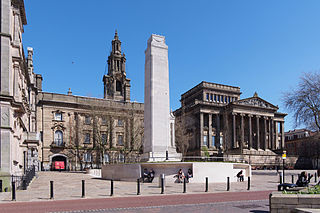
Preston is a city on the north bank of the River Ribble in Lancashire, England. The city is the administrative centre of the county of Lancashire and the wider City of Preston local government district. Preston and its surrounding district obtained city status in 2002, becoming England's 50th city in the 50th year of Queen Elizabeth II's reign. Preston has a population of 114,300, the City of Preston district 132,000 and the Preston Built-up Area 313,322. The Preston Travel To Work Area, in 2011, had a population of 420,661, compared with 354,000 in the previous census.

Farington is a village and civil parish in the South Ribble local government district of Lancashire, England. The population of the civil parish at the 2011 census was 6,674.

Lostock Hall is a suburban village within the South Ribble borough of Lancashire, England. It is located on the south side of the River Ribble, some 3 miles (4.8 km) south of Preston and 2.5 miles (4 km) north of Leyland. It is bordered on its southeastern side by the interchange for the M6, M61 and M65 motorways. At the time of the United Kingdom Census 2001, the central Lostock Hall area had a population of 3,948, falling to 3,762 at the 2011 Census.
Bamber Bridge is an urban village in Lancashire, England, 3 miles (5 km) south-east of Preston, in the borough of South Ribble. The name derives from the Old English "bēam" and "brycg", which probably means "tree-trunk bridge". The population was 13,945 at the 2011 Census.

Penwortham is a town in South Ribble, Lancashire, England, on the south bank of the River Ribble facing the city of Preston. The town is at the most westerly crossing point of the river, with major road and rail links crossing it here. The population of the town at the 2011 census was 23,047.

Fulwood is an area and unparished area in Lancashire, England, forming much of the northern half of the unparished part of the City of Preston district. It had a population of 28,535 in 2011 and is made up of five wards.

The City Council elections for the City of Preston, Lancashire were held on 4 May 2006 on the same day as other 2006 United Kingdom local elections. Nineteen electoral wards were fought. The only change was that Labour gained one seat from the Liberal Democrats, continuing to be the largest party, but the Council remained under no overall control

Elections to the Preston City Council took place on 3 May 2007.
Elections to Preston Borough Council were held on 6 May 1999. One third of the council was up for election and the Labour party kept overall control of the council after a Liberal Democrat councillor defected to them on the night of the counting of the votes.

Ashton-on-Ribble is a suburb of Preston, Lancashire, England. The population of the Ashton Ward taken at the 2011 census was 4,459.

Avenham and Frenchwood are the central communities which make up the Town Centre ward of Preston City Council, in Lancashire, England. The name of the ward was chosen by the Boundary Committee for England prior to Preston being awarded city status.

Tulketh is an electoral ward in Preston, Lancashire, England. The Tulketh Mill is a notable landmark in the ward.
Deepdale is an electoral ward in Preston, Lancashire, England. The population of the ward as taken at the 2011 census was 6,103. The ward is home to the Deepdale football stadium of Preston North End. The ward is a predominantly urban area of terraced housing, notable for one of the largest South Asian populations in the city.

Ingol is an electoral ward and suburb of Preston, Lancashire, England. The population of the Ward as taken at the 2011 census was 7,369. The ward also includes the district of Tanterton. The ward is coterminous with the civil parish of Ingol and Tanterton, created in 2012.

Larches is one of the districts of Preston, Lancashire, England. The area, north-west of Preston city centre, is a mix of social and private housing, although both components of the ward – Larches, and Savick – are largely post-war council estates. Ashton Park is in the middle of the current ward, which borders Riversway and the civil parish of Lea. The area of Larches is part of Ashton-on-Ribble, which was part of the former hundred of Amounderness. With small businesses and shops in the area, the population are largely commute-to-work families and retirees. The citywide Preston Bus service runs through both sides of the Larches ward, and routes operated by Stagecoach between Preston and Blackpool also serve the area. Three members of Preston City Council, elected 'in thirds' in first past the post elections each year, are returned from the ward. The ward and neighbouring Ashton forms part of the Lancashire County Council electoral division of Preston North West.

College is an electoral ward and one of the districts of Preston. The population of the Ward as taken at the 2011 census was 3,578. College is in the Fulwood area in northern Preston, Lancashire, England. The ward is based in the Sharoe Green area with the name being derived from the central placement of Preston College.

St Matthew's is an electoral ward in Preston, Lancashire, England. The ward is adjacent to the larger Ribbleton to the east but is considered to be an area with a distinct community of its own.

Preston is a city in Lancashire, around 50 kilometres (31 mi) north-west of Manchester.

The City of Preston is a city and non-metropolitan district in Lancashire, England. On the north bank of the River Ribble, it was granted city status in 2002, becoming England's 50th city in the 50th year of Queen Elizabeth II's reign. The City of Preston district has a population of 143,135 (mid-2019 est.), and lies at the centre of the Central Lancashire sub-region, with a population of 335,000.
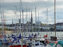
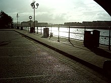
Preston Dock was a former maritime dock located on the northern bank of the River Ribble approximately 2.5 km (1.6 mi) west of Preston's town centre in Lancashire, England. It is the location of the Albert Edward Basin which opened in 1892 and is connected to the river by a series of locks.