
The Pembrokeshire Coast Path, often called the Pembrokeshire Coastal Path, is a designated National Trail in Pembrokeshire, southwest Wales. Established in 1970, it is a 186-mile (299 km) long-distance walking route, mostly at cliff-top level, with a total of 35,000 feet (11,000 m) of ascent and descent. At its highest point – Pen yr afr, on Cemaes Head – it reaches a height of 574 feet (175 m), and at its lowest point – Sandy Haven crossing, near Milford Haven – it is just 6 feet (2 m) above low water. Whilst most of the coastline faces west, it offers – at varying points – coastal views in every direction of the compass.

Pembrokeshire is a county in the south-west of Wales. It is bordered by Carmarthenshire to the east, Ceredigion to the northeast, and is otherwise surrounded by the sea. Haverfordwest is the largest town and administrative headquarters of Pembrokeshire County Council.

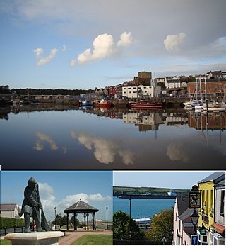
Haverfordwest is the county town of Pembrokeshire, Wales, and the most populous urban area in Pembrokeshire with a population of 14,596 in 2011. It is also a community, being the second most populous community in the county, with 12,042 people, after Milford Haven. The suburbs include the former parish of Prendergast, Albert Town and the residential and industrial areas of Withybush.
Milford Haven is both a town and a community in Pembrokeshire, Wales. It is situated on the north side of the Milford Haven Waterway, an estuary forming a natural harbour that has been used as a port since the Middle Ages. The town was founded in 1790 by Sir William Hamilton, who designed a grid pattern. It was originally intended to be a whaling centre, though by 1800 it was developing as a Royal Navy dockyard which it remained until the dockyard was transferred to Pembroke in 1814. It then became a commercial dock, with the focus moving in the 1960s, after the construction of an oil refinery built by Esso, to logistics for fuel oil and liquid gas. By 2010, the town's port had become the fourth largest in the United Kingdom in terms of tonnage, and continues its important role in the United Kingdom's energy sector with several oil refineries and one of the biggest LNG terminals in the world.

Pembroke Dock is a town and a community in Pembrokeshire, South West Wales, 3 miles (4.8 km) northwest of Pembroke on the banks of the River Cleddau. Originally Paterchurch, a small fishing village, Pembroke Dock town expanded rapidly following the construction of the Royal Navy Dockyard in 1814. The Cleddau Bridge links Pembroke Dock with Neyland.

Neyland is a town and community in Pembrokeshire, Wales, lying on the River Cleddau and the upstream end of the Milford Haven estuary. The Cleddau Bridge carrying the A477 links Pembroke Dock with Neyland.

Dale is both a small village and a community in Pembrokeshire, Wales, located on the peninsula which forms the northern side of the entrance to the Milford Haven Waterway. The village has 205 inhabitants according to the 2001 census, increasing to 225 at the 2011 Census.

Thankful Villages are settlements in England and Wales from which all their members of the armed forces survived World War I. The term Thankful Village was popularised by the writer Arthur Mee in the 1930s; in Enchanted Land (1936), the introductory volume to The King's England series of guides, he wrote that a Thankful Village was one which had lost no men in the war because all those who left to serve came home again. His initial list identified 32 villages. There are tens of thousands of villages and towns in the United Kingdom.

Milford Haven Waterway is a natural harbour in Pembrokeshire, Wales. It is a ria or drowned valley which was flooded at the end of the last ice age. The Daugleddau estuary winds west to the sea. As one of the deepest natural harbours in the world, it is a busy shipping channel, trafficked by ferries from Pembroke Dock to Ireland, oil tankers and pleasure craft. Admiral Horatio Nelson, visiting the haven with the Hamiltons, described it as the next best natural harbour to Trincomalee in Ceylon and "the finest port in Christendom". Much of the coastline of the Waterway is designated as a Site of Special Scientific Interest, listed as Milford Haven Waterway SSSI.

Carew is a village, parish and community on an inlet of Milford Haven in the former Hundred of Narberth, Pembrokeshire, West Wales, 4 miles (6.4 km) east of Pembroke. The eastern part of the parish is in the Pembrokeshire Coast National Park.
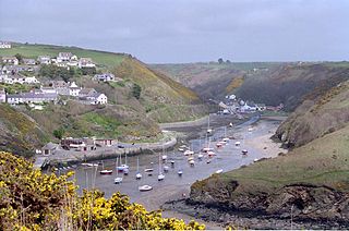
Solva is a village, community and electoral ward in Pembrokeshire, Wales. The village comprises principally Lower Solva and Upper Solva. The community also includes Middle Mill and Whitchurch.

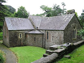
Rhoscrowther was a village, ecclesiastical parish and civil parish in Pembrokeshire, Wales on the south shore of the Milford Haven Waterway. The placename is Welsh and perhaps means "crwth-player's moor". It is part of the community of Angle.

Catwick is a village and civil parish in the East Riding of Yorkshire, England. It is situated approximately 7.5 miles (12 km) north-east of Beverley town centre and 5 miles (8 km) west of Hornsea town centre. It lies on the A1035 road from Leven to Hornsea.
St Ishmaels or St Ishmael's is a village, parish and community close to the Milford Haven Waterway in Pembrokeshire, Wales. The community comprises most of the parish of St Ishmaels and had a population of 478 at the 2011 census. The ward includes the communities of Herbrandston, Dale and Marloes and St. Brides. The community was subsequently merged with other communities and only the ward remained with the name St Ishmael's. This covers the entire peninsula with at total population at the 2011 census of 1,405.

Steynton or Stainton is a parish in the county of Pembrokeshire, Wales, formerly in the hundred of Rhôs and now an area of Milford Haven and in the Community of Tiers Cross. The parish includes the hamlet of Dreenhill, near Haverfordwest. The parish population is about 3,000.

The Pembroke Refinery is an oil refinery situated on the Pembrokeshire coast in Wales at Rhoscrowther in the community of Angle. It first came on stream in 1964 and was Regent/Texaco's only British refinery. The refinery occupies a prominent position on the south bank of the Milford Haven Waterway and can be seen for many miles. Around a quarter of the site is within the Pembrokeshire Coast National Park which was created in 1952.

Hubberston is a coastal village in Pembrokeshire, Wales. It belongs to the parish of Hubberston in the historical hundred of Roose. It is located directly to the west of the larger town of Milford Haven, and is a district of the community of Milford Haven. It is adjacent to the village of Hakin. It had a population of 2,390 inhabitants in 2001. It is mainly residential in nature.
The town of Milford Haven was founded in 1793 by Sir William Hamilton, who initially invited Quaker whalers from Nantucket to live in his town, and then, in 1797, the Navy Board to create a dockyard for building warships.
Tavernspite is a small village about 6 miles (9.7 km) southeast of Narberth in Pembrokeshire, southwest Wales. It lies on the B4314 Pendine to Templeton road, close to the border with Carmarthenshire and is in Lampeter Velfrey community and parish. It is a historical meeting point of several roads. The population at the 2011 census was 349.
The Pembrokeshire League is a football league in Pembrokeshire, West Wales, running from levels five to nine of the Welsh football league system.


