
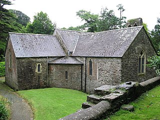
Cenarth is a village, parish and community in Carmarthenshire, on the border between Ceredigion and Carmarthenshire, and close to the border with Pembrokeshire, Wales. It stands on the banks of the River Teifi, 6 miles (9.7 km) east of Cardigan and 4 miles (6.4 km) west of Newcastle Emlyn, and features the Cenarth Falls, a popular visitor attraction, and several other listed structures including an 18th-century corn mill incorporating the National Coracle Centre.

Spittal is both a village, a parish and a community in Pembrokeshire, Wales, on the A40 trunk road, approximately halfway between Haverfordwest and Fishguard.

St Dogmaels is a village, parish and community in Pembrokeshire, Wales, on the estuary of the River Teifi, a mile downstream from the town of Cardigan in neighbouring Ceredigion. A little to the north of the village, further along the estuary, lies Poppit Sands beach. The parish includes the small settlement of Cippyn, south of Cemaes Head.

Saundersfoot is a large village and community in Pembrokeshire, Wales. It is near Tenby, both being holiday destinations. Saundersfoot lies in the Pembrokeshire Coast National Park and on the Pembrokeshire Coast Path. The village population was 3,361 in 2011. while the community had a population of 2,628.

Llawhaden is a village, parish and community in the Hundred of Dungleddy, Pembrokeshire, West Wales. The community of Llawhaden includes the parish of Robeston Wathen, part of Narberth and the hamlet of Gelli, and had a population of 634 in 2001, increasing to 688 at the 2011 Census.

Monkton is a village and parish adjoining Pembroke, Pembrokeshire, Wales. According to the United Kingdom Census 2001, the population was 1,688.
Maenclochog is a village, parish and community in Pembrokeshire, south-west Wales. It is also the name of an electoral ward comprising a wider area of four surrounding communities. Maenclochog Community includes the small settlement of Llanycefn and the village of Rosebush.
St Ishmaels or St Ishmael's is a village, parish and community close to the Milford Haven Waterway in Pembrokeshire, Wales. The community comprises most of the parish of St Ishmaels and had a population of 478 as of the 2011 census. The ward includes the communities of Herbrandston, Dale and Marloes and St. Brides. The community was subsequently merged with other communities and only the ward remained with the name St Ishmael's. This covers the entire peninsula with at total population at the 2011 census of 1,405.

Bletherston is a small settlement and parish in Pembrokeshire, Wales. It is in the middle of eastern Pembrokeshire, 6 miles (9.7 km) north of Narberth and 8 miles (13 km) northeast of Haverfordwest. The parish includes the village of Penffordd. Together with the parishes of Llys y Fran and New Moat, it constitutes the community of New Moat.

Brawdy is a village and community in Pembrokeshire, Wales.

Castlebythe is a village and parish in Pembrokeshire, Wales, on the southern slopes of the Preseli Hills, 10 km south-east of Fishguard. The northern part of the parish is in the Pembrokeshire Coast National Park. Together with the parishes of Henry's Moat, Little Newcastle, Morvil and Puncheston, it constitutes the community of Puncheston.

Pencaer is a community which covers an area of dispersed settlement in Pembrokeshire, Wales, on the peninsula of Pen Caer and comprises the village of Llanwnda and the smaller settlements of Granston, Llangloffan, St Nicholas (Tremarchog) and Trefasser. The population of the community taken at the 2011 census was 474.
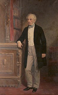
Sir John Henry Scourfield, 1st Baronet was a Welsh Conservative politician who sat in the House of Commons from 1852 to 1876.
Llandeloy is a small village and parish in Pembrokeshire, South West Wales. Together with the parishes of Brawdy and Llanreithan, it constitutes the community of Brawdy, which had a census population of 611 in 2001.
William Henry Scourfield was a Welsh landowner and Tory politician.

Llanddewi Velfrey or Llandewi Velfrey is a village, parish and community of Pembrokeshire in West Wales. Historically it was in the Narberth Hundred. The village is in Lampeter Vale, 2 miles (3 km) northeast of Narbeth along the A40. In 1831 it had a population of 710 people. In 2011 the population was 393.

Rudbaxton is a village, parish and a local government community in the county of Pembrokeshire, Wales. It is 81 miles (130 km) from Cardiff and 208 miles (335 km) from London.

Llandissilio is a village and parish in the community of Llandissilio West in east Pembrokeshire, Wales on the A478 road between Efailwen to the north and Clunderwen to the south. A largely ribbon development along the main road, the village is surrounded by farmland.

Llys y Fran is a small village and parish in the community of New Moat on the southern slopes of the Preseli Mountains in Pembrokeshire, Wales. The parish includes the small settlement of Gwastad. A notable feature is Llys y Fran Reservoir and Country Park, a popular tourist attraction.

Prendergast is a former village and parish in Pembrokeshire, Wales, now a suburb of Haverfordwest, Pembrokeshire's county town. The name survives as an electoral ward of Haverfordwest. The Western Cleddau forms the parish's western boundary, and the Hiog, a tributary of the Cleddau, the eastern boundary.


