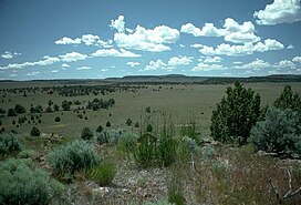
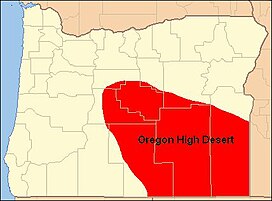
The Oregon High Desert is a region of the U.S. state of Oregon located east of the Cascade Range and south of the Blue Mountains, in the central and eastern parts of the state. Divided into a southern region and a northern region, the desert covers most of five Oregon counties and averages 4,000 feet (1,200m) above sea level. The southwest region is part of the Great Basin and the southeast is the lower Owyhee River watershed. The northern region is part of the Columbia Plateau, where higher levels of rainfall allow the largest industry on private land to be the cultivation of alfalfa and hay. Public land within the region is owned primarily by the Bureau of Land Management, which manages more than 30,000 square miles (78,000km2) including five rivers designated as Wild and Scenic.
While the high desert is somewhat dry, it is only arid relative to Western Oregon. The region averages 15 inches (380mm) of annual rainfall; the Alvord Desert, however, receives only 7 inches (180mm) of rain each year. Contrary to its name, most of the high desert is not dry enough to truly qualify as desert, and biologically, most of the region is classified as shrubland or steppe.
At 9,733 feet (2,967m) above sea level, the summit of Steens Mountain is the highest point in the high desert. The broad fault-block mountain is characteristic of the basin and rangeplate tectonics of the high desert. About 16million years ago, during the early Miocene epoch, lava flows from volcanic eruptions covered about half the surface area of Oregon. The Earth's crust then began stretching, giving way to further volcanic activity from 15million to 2million years ago. Several ice ages over this time formed the large lakes in the high desert.
The high desert of Oregon is located in the central and southeastern parts of the state. It covers approximately 24,000 square miles (62,000km2), extending approximately 200 miles (320km) from central Oregon east to the Idaho border and 130 miles (210km) from central Oregon south to the Nevada border.[1] Most of the region is located in Crook, Deschutes, Harney, Lake, and Malheur counties.[1][2][3]
The high desert is named as such for its generally high elevation, averaging about 4,000 feet (1,200m) across the region.[4] It is bordered by the eastern foothills of the Cascade Range to the west. The Blue Mountains are the geographical boundary to the north, marking the northern end of the high desert's semi-arid plateau. The southern high desert is part of North America's Basin and Range Province, which extends south through Nevada and Arizona and into Mexico. It contains large alkali lakes and tall cliffs, some with a prominence of more than 2,000 feet (610m). Steens Mountain, in Harney County, is the highest point within the region; its summit is 9,733 feet (2,967m) above sea level.[2][5][6][7][8] To the east, the high desert country of the Columbia Plateau extends across the Snake River and into Idaho.[7]
The largest landowner in eastern Oregon is the U.S. government. The Bureau of Land Management administers over 13.6million acres (55,000km2) in the bureau's Burns, Lakeview, Prineville, and Vale districts, most of which are in the state's high desert country.[13] In addition, Congress has designated specific sections of the Crooked, Deschutes, Donner und Blitzen, Malheur, and Owyhee rivers as part of the National Wild and Scenic Rivers System.[14]
Agriculture is the largest industry in the region. Livestock ranches utilize large tracts of private and government land for grazing. Ranchers raise cattle and sheep in many parts of the region. Because of low rainfall, most crops require irrigation. Agricultural crops include alfalfa and other hay crops, wheat, oats, barley, potatoes, onions, sugar beets, and mint.[15][16]
Geology
Like other lakes in the high desert, Goose Lake was formed when glaciers melted after ice ages during the Pleistocene epoch.
Between 17 and 15million years ago, magma from deep beneath eastern Oregon rose to the Earth's surface, causing a period of significant volcanic activity. A series of lava floods erupted from fissures near the Oregon–Idaho–Washington border. The resulting lava flows traveled up to 400 miles (640km) from their source. Some individual flows covered as much as 10,000 square miles (26,000km2) to a depth of 100 feet (30m). Eventually, these lava flows covered half the state of Oregon, creating a formation known as the Columbia River Basalt Group, the geologic foundation beneath much of the high desert.[17]
After the original eruptions subsided, the Earth's crust began to stretch and crack. Between 15 and 2million years ago, this created hundreds of new volcanoes that added additional layers of lava on top of the Columbia River Basalt and left behind hundreds of lava tubes.[18] These new flows blanketed the southeastern third of the state. Many of the volcanoes and smaller cinder cones from this period still exist in eastern Oregon. Afterward, subsequent rifting produced large fault-block mountains throughout the region. The escarpment-type mountains and high-elevation valleys created by these faults produced the basin and range landscape that makes up much of Oregon's high desert country.[19][20]
During the last 2million years, a series of ice ages altered the landscape. As each ice sheet melted, runoff and increased rainfall filled many of the region's closed basins, forming large pluvial lakes. The Goose Lake, Harney, and Klamath basins were filled along with many other smaller basins. Some of the lakes covered as much as 1,000 square miles (2,600km2). However, as the climate became drier, these large lakes shrank away. Goose Lake, Harney Lake, Malheur Lake, Summer Lake, Lake Abert, and the Warner Lakes are remnants of ancient pluvial lakes.[8]
Climate
Annual precipitation throughout Oregon's high desert region is relatively low, averaging less than 15 inches (380mm) per year in most areas. Bend, the region's largest city, only receives 12 inches (300mm) of precipitation per year. Burns receives roughly 11 inches (280mm) of precipitation annually, while Rome, in central Malheur County, and the official weather station at Whitehorse Ranch in southern Harney County receive only 8 inches (200mm) in an average year. Some of the mountainous areas, however, receive significantly more precipitation as snowfall. For example, the high-elevation city of Lakeview has an average annual snowfall of nearly 68 inches (1,700mm).[21][15][22]
The majority of high desert areas receive most precipitation in the winter months, decreasing steadily through late summer into the fall. Some areas in the eastern and southern parts of the region receive peak precipitation in the late spring and early summer. For example, at Hart Mountain in Lake County, the wettest time of the year is March through June. The driest months throughout Oregon's high desert are July through September, though there are still isolated thunderstorms during that period.[21][15]
Monthly normal high and low temperatures (°F) for various Oregon high desert cities
The indigenous people of the high desert region are the Northern Paiute people. These Native Americans were once semi-nomadic hunter-gatherers who relied on nuts, roots, seeds, berries, eggs, and animals such as deer, pronghorn, geese, quail, rabbits, and bear,[24][25][26] following their food to high and low elevations depending on the time of year.[25] They make sandals, traps, fishing nets, and weave baskets. Made out of sagebrush, willow, tule plant, Indian hemp, and sumac fibers, the baskets are tight enough to carry water. Archaeological evidence from near Fort Rock has shown that people wove baskets in the area at least 9,000years ago.[27][28]
Throughout the 18thcentury and into the early 19thcentury, the Northern Paiute had numerous conflicts with tribes who lived to the northwest. The Wasco-Wishram and other Chinook tribes often encroached on the high desert landscape of the Northern Paiute territory. After one such incident in 1811, the Northern Paiute migrated north to the Columbia River and attacked Wasco canoes. Around this time, the Northern Paiute numbered approximately 7,500.[29][30] The Snake War, a war between the natives and Euro-American settlers in the region in the 1860s, killed roughly two-thirds of the Northern Paiute population. The settlers won the war and then set aside the Malheur Reservation for the Northern Paiute and other Oregon Native American tribes.[30]
Settlers who had traveled to Oregon along the Oregon Trail began to live in the high desert region in the 1850s and 1860s after they had begun farming and logging in the Willamette Valley and other lands in western Oregon. Thousands of these emigrants reached the area from the west, crossing the Cascade Range to make land claims in eastern Oregon.[31] The high desert area was settled by Euro-Americans later than western Oregon was in part because of Elijah White's failure to find a pass east through the Cascades.[32] Once they had claimed more land, pioneers and members of the American government negotiated treaties with natives in the high desert and elsewhere in Oregon, often forcing them off their native lands and onto reservations.[33]
In 1866, American soldiers established Camp Warner, a military camp near present-day Hart Mountain National Antelope Refuge in Lake County. They were sent from Boise, Idaho, to build a military camp in the high desert, and they built it east of the Warner Lakes because they doubted that they could cross the series of wetlands. Maj. Gen. George Crook disapproved of the soldiers' decision. He built a road across the lakes and moved the camp to the western side of them.[34]
Of the four major cities in the high desert, Prineville was established earliest. Its post office originally opened under the name "Prine" in 1871. It was named for Barney Prine, a whisky and metal merchant in the area.[35]Lakeview's post office was then established in 1876. At that time, Goose Lake was larger, and it was visible from the post office.[36] The Burns post office opened in 1884 and the city was established in 1891. It was named for the Scottish poet Robert Burns.[37]Bend's name was derived from the phrase "Farewell Bend," the location where pioneers traveling through the area last saw the Deschutes River. The Bend post office was established in 1904.[38]
In 1878, the Bannock people and northern Shoshone tribes participated in the Bannock War, a war against Euro-American settlers in the region over the destruction of camas root—a major source of food for the natives—by settlers' hogs. The Bannock and the Northern Paiute suffered from violence during the conflict, and once the settlers had won the war, the natives were allotted to various reservations. The Northern Paiute were sent to the Yakama Indian Reservation and in later years have been dispersed throughout several reservations in the western United States.[39][40]
Euro-American settlers created the 13,736-acre (5,559ha) Burns Paiute Reservation, just north of Burns, in 1897.[28][41] The reservation was established in 1972. It is home to the descendants of the Wada Tika band of Northern Paiutes. As of 1992, it had 356 members.[28][42][43] As of 1980, there were 57 descendants of the Northern Paiute tribe living outside of the reservation.[44]
Place names
In the 19thcentury, Oregon's high desert area was called the Great Sandy Desert (a misnomer, as there is very little sand in the region), the Rolling Sage Plain, and the Artemisia Desert. Over the years, the region has also been known as Oregon's Empty Quarter, the Great Wide Open, and Oregon's Cowboy Country. Today, many local residents call it the Oregon Outback. However, the old names are occasionally still used. A 1996 National Geographic magazine "Map of the United States Physical Landscape" used the pioneer name, Great Sandy Desert, to identify the southeastern quarter of Oregon. However, the region is most commonly known as Oregon's "High Desert".[2][45] "High Desert" is the official name for a plain in Deschutes County, as recognized by the United States Board on Geographic Names. Variant names for the high desert are "Great Sandy Desert" and "Rolling Sage Plains".[46]
Flora and fauna
Mule deer rely on grasses and flowers in the high desert.Prairie falcons live off of the region's abundance of small mammals.
Harney County is one of the 36 counties in the U.S. state of Oregon. As of the 2020 census, the population was 7,495, making it the sixth-least populous county in Oregon. The county seat is Burns. Established in 1889, the county is named in honor of William S. Harney, a military officer of the period, who was involved in the Pig War and popular in the Pacific Northwest.
Burns is a city in and the county seat of Harney County, in the U.S. state of Oregon. According to the 2010 census, the population was 2,806. Burns and the nearby city of Hines are home to about 60 percent of the people in the sparsely populated county, by area the largest in Oregon and the ninth largest in the United States.
The Northern Paiute people are a Numic tribe that has traditionally lived in the Great Basin region of the United States in what is now eastern California, western Nevada, and southeast Oregon. The Northern Paiutes' pre-contact lifestyle was well adapted to the harsh desert environment in which they lived. Each tribe or band occupied a specific territory, generally centered on a lake or wetland that supplied fish and waterfowl. Communal hunt drives, which often involved neighboring bands, would take rabbits and pronghorn from surrounding areas. Individuals and families appear to have moved freely among the bands.
The Malheur River is a 190-mile-long (306 km) tributary of the Snake River in eastern Oregon in the United States. It drains a high desert area, between the Harney Basin and the Blue Mountains and the Snake.
The Indigenous peoples of the Great Basin are Native Americans of the northern Great Basin, Snake River Plain, and upper Colorado River basin. The "Great Basin" is a cultural classification of indigenous peoples of the Americas and a cultural region located between the Rocky Mountains and the Sierra Nevada, in what is now Nevada, and parts of Oregon, California, Idaho, Wyoming, and Utah. The Great Basin region at the time of European contact was ~400,000 sq mi (1,000,000 km2). There is very little precipitation in the Great Basin area which affects the lifestyles and cultures of the inhabitants.
The Harney Basin is an endorheic basin in southeastern Oregon in the United States at the northwestern corner of the Great Basin. One of the least populated areas of the contiguous United States, it is located largely in northern Harney County, bounded on the north and east by the Columbia Plateau—within which it is contained, physiographically speaking—and on the south and west by a volcanic plain. The basin encompasses an area of 1,490 square miles (3,859 km2) in the watershed of Malheur Lake and Harney Lake. Malheur Lake is a freshwater lake, while Harney Lake is saline-alkaline.
Steens Mountain is in the southeastern part of the U.S. state of Oregon, and is a large fault-block mountain. Located in Harney County, it stretches some 50 miles (80 km) north to south, and rises from the west side the Alvord Desert at elevation of about 4,200 feet (1,300 m) to a summit elevation of 9,738 feet (2,968 m). Steens Mountain is not part of a mountain range but is properly a single mountain, the largest of Oregon's fault-block mountains.
Drewsey is an unincorporated community in Harney County, in the U.S. state of Oregon. Drewsey is along the main stem of the Malheur River, about 45 miles (72 km) east of Burns, off U.S. Route 20. It has the ZIP Code of 97904.
Meek Cutoff was a horse trail road that branched off the Oregon Trail in northeastern Oregon and was used as an alternate emigrant route to the Willamette Valley in the mid-19th century. The road was named for frontiersman Stephen Meek, who was hired to lead the first wagon train along it in 1845. The journey was a particularly hard one, and many of the pioneers lost their lives.
Central Oregon is a geographic region in the U.S. state of Oregon and is traditionally considered to be made up of Deschutes, Jefferson, and Crook counties. Other definitions include larger areas, often encompassing areas to the north towards the Columbia River, eastward towards Burns, or south towards Klamath Falls. These three counties have a combined population of 200,431 as of the 2010 census, with Deschutes the largest of the three counties, having approximately four times the population of the other two counties combined. As of 2015, the most populous city in the region is Bend, with an estimated 87,014 residents. As defined by the three county definition, Central Oregon covers 7,833 square miles (20,290 km2) of land. Central Oregon has had 3 record tourism years beginning in 2012. Over 2.2 million people visited Central Oregon in 2012 and again in 2013.
Winnemucca was a Northern Paiute war chief. He was born a Shoshone around 1820 in what would later become the Oregon Territory.
Malheur National Wildlife Refuge is a National Wildlife Refuge located roughly 30 miles (48 km) south of the city of Burns in Oregon's Harney Basin. Administered by the United States Fish and Wildlife Service, the refuge area is roughly T-shaped with the southernmost base at Frenchglen, the northeast section at Malheur Lake and the northwest section at Harney Lake.
The Elliott Cutoff was a covered wagon road that branched off the Oregon Trail at the Malheur River where present-day Vale, Oregon, United States is today. The first portion of the road was originally known as the Meek Cutoff after Stephen Meek, a former trapper who led over 1,000 emigrants into the Harney Basin in 1845. There were considerable difficulties for the 1845 train, and after reaching a hill known as Wagontire, the people left Meek and split into groups. They turned north at the Deschutes River and finally returned to the traditional Oregon Trail near The Dalles.
Malheur Lake is one of the lakes in the Malheur National Wildlife Refuge in Harney County in the U.S. state of Oregon. Located about 18 miles (29 km) southeast of Burns, the lake is marsh fed by the Donner und Blitzen River from the south and the Silvies River from the north. Malheur Lake periodically overflows into Mud Lake to the west and thence to Harney Lake, the sink of Harney Basin.
Harney Lake is a shallow alkali lake basin located in southeast Oregon, United States, approximately 30 miles (48 km) south of the city of Burns. The lake lies within the boundary of the Malheur National Wildlife Refuge and is the lowest point in the Blitzen Valley drainage.
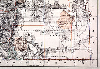
The Malheur Indian Reservation was an American Indian reservation established for the Northern Paiute in eastern Oregon and northern Nevada from 1872 to 1879. The federal government discontinued the reservation after the Bannock War of 1878, under pressure from European-American settlers who wanted the land. This negative recommendation against continuing by its agent William V. Rinehart, led to the internment of more than 500 Paiute on the Yakama Indian Reservation, as well as the reluctance of the Bannock and Paiute to return to the lands after the war.
The Northern Basin and Range ecoregion is a Level III ecoregion designated by the United States Environmental Protection Agency (EPA) in the U.S. states of Oregon, Idaho, Nevada, Utah, and California. It contains dissected lava plains, rolling hills, alluvial fans, valleys, and scattered mountain ranges in the northern part of the Great Basin. Although arid, the ecoregion is higher and cooler than the Snake River Plain to the north and has more available moisture and a cooler climate than the Central Basin and Range to the south. Its southern boundary is determined by the highest shoreline of Pleistocene Lake Bonneville, which once inundated the Central Basin and Range. The western part of the region is internally drained; its eastern stream network drains to the Snake River system.
Fort Harney was a United States Army outpost in eastern Oregon in the United States. It was named in honor of Brigadier General William S. Harney. Fort Harney was used as a supply depot and administrative headquarters from 1867 to 1880 during the Army's campaign against Northern Paiute bands in Eastern Oregon and the Bannock uprising in the same area. Today, nothing remains of Fort Harney except a small cemetery.
The Burns Paiute Tribe of the Burns Paiute Indian Colony of Oregon is a federally recognized tribe of Northern Paiute Indians in Harney County, Oregon, United States.
The Double-O Ranch Historic District is located west of Harney Lake in Harney County in southeastern Oregon, United States. At one time, the Double-O Ranch covered over 17,000 acres (69 km2). The ranch was owned by Bill Hanley, a well-known cattle baron and Bull Moose progressive. In 1941, the United States Government purchased most of the Double O Ranch property and added it to the Malheur National Wildlife Refuge. The two remaining Double-O Ranch buildings are now listed on the National Register of Historic Places.
↑ Carmichael, Suzanne (June 12, 1994). "Oregon's High Desert". The New York Times. New York, New York. Archived from the original on October 10, 2012. Retrieved November 14, 2011.
1 2 Taylor, George. "Climate of Lake County". Oregon State University, Oregon Climate Service. Archived from the original on February 15, 2006. Retrieved November 15, 2011.
↑ Taylor, George. "Climate of Crook County". Oregon State University, Oregon Climate Service. Archived from the original on June 12, 2010. Retrieved November 20, 2011.
↑ Allen, Cain (2005). "Paiute Water Basket". Historical Records. Oregon Historical Society. Archived from the original on February 2, 2014. Retrieved November 19, 2011.
1 2 3 "Burns Paiute Tribe". Oregon Blue Book. Oregon State Archives. Archived from the original on October 25, 2018. Retrieved November 19, 2011.
↑ LaLande, Jeff. "High Desert History". Oregon History Project. Oregon Historical Society. Archived from the original on August 22, 2011. Retrieved November 14, 2011.
↑ "Oregon's Large Mammals"(PDF). Oregon Department of Fish and Wildlife. p.5. Archived(PDF) from the original on October 16, 2011. Retrieved November 16, 2011.
↑ "Prairie Falcon"(PDF). Yolo Natural Heritage Program. April 20, 2009. p.2. Archived(PDF) from the original on October 8, 2011. Retrieved November 16, 2011.
↑ Bureau of Land Management; National Park Service. "Basin and Range Birding Trail"(PDF). Basin & Range Birding Trail. Archived from the original(PDF) on July 7, 2011. Retrieved November 16, 2011.
— "Oregon: A Geologic History". Oregon Department of Geology and Mineral Industries. Archived from the original on May 7, 2012. Retrieved November 14, 2011.
Bancroft, Hubert H.; Victor, Frances F. (1886). History of Oregon. The Works of Hubert Howe Bancroft. Vol.1. San Francisco, California: The History Company. ISBN0-665-14180-7. OCLC9475552.
Brogan, Phil F. (1964). East of the Cascades. Portland, Oregon: Binfords and Mort. OCLC2018809.
Kessel, William B.; Wooster, Robert (2005). Encyclopedia of Native American Wars and Warfare. New York, New York: Facts on File. ISBN0-8160-3337-4. OCLC44509237.
This page is based on this Wikipedia article Text is available under the CC BY-SA 4.0 license; additional terms may apply. Images, videos and audio are available under their respective licenses.