Hyperspectral Imager for the Coastal Ocean

Last updated
Hyperspectral Imager for the Coastal Ocean (HICO) on the International Space Station. Hyperspectral Imager for the Coastal Ocean (HICO) on International Space Station.jpg
Hyperspectral Imager for the Coastal Ocean (HICO) on the International Space Station.

The Hyperspectral Imager for the Coastal Ocean (HICO) was a hyperspectral earth observation sensor that operated on the International Space Station (ISS) from 2009 to 2014. HICO collected hyperspectral satellite imagery of the earth's surface from the ISS. [1] [2] [3]

Contents

HICO was a pathfinder or proof-of-concept mission for hyperspectral imaging of the oceans, particularly for optically complex coastal waters. [4] The dataset collected by HICO serves as an example dataset for future hyperspectral satellite missions such as PACE.

HICO was mounted directly on the ISS rather than on a separate unmanned satellite platform (i.e., distinct from the MODIS sensor mounted on Aqua and Terra satellites and from SeaWiFS mounted on OrbView-2 aka Seastar satellite). As such, HICO was tasked to collect images of certain regions in sync with the daytime orbit path of the ISS. Further, its data record may contain some gaps in time for operational tasks on board the ISS such as spacewalks and docking.

History

HICO was developed by the United States Office of Naval Research. The sensor was launched on September 10, 2009, from the Tanegashima Space Center in Japan as payload for the ISS on the H-2B-304 rocket (including HTV-1 transfer vehicle). It was installed on September 24, 2009, onto the Japanese Experiment Module Exposed Facility of the Kibo Laboratory (Japanese Kibo complex) of the ISS by two Expedition-20 engineers, ESA astronaut Frank De Winne and NASA astronaut Nicole Stott. HICO was installed concurrently with the RAIDS/Remote Atmospheric and Ionospheric Detection System: together these two systems are referred to as the “HICO and RAIDS Experiment Payload (HREP or HREP-RAIDS).” [5] HICO Collected over 10,000 images during its operating lifetime. [3] Financial support came from the United States Office of Naval Research, the United States Department of Defense, and later from the International Space Station Program.

In summer 2013 HICO data became publicly available [6] and remain freely accessible today.

HICO stopped collecting data in September 2014 when radiation from a solar flare damaged its computer. Attempts to restart the computer were unsuccessful. [7] The last image date and official end of operations was September 13, 2014.

After the end of its lifetime, HICO and RAIDS Experiment Payload (HREP) was removed from the ISS on August 3, 2018, on the SpaceX CRS-15 Dragon space capsule after its July–August 2018 resupply mission. The Dragon's trunk section burned up during re-entry, disposing of the HICO instrument and other contents. The flight that offloaded HICO was the fourth ever round-trip cargo flight with a reused Dragon capsule. [8]

Technical specifications and data products

Hyperspectral imagery (right) uses more spectral bands or more colors of light, providing more information to identify different types of terrain. Mono, Multi and Hyperspectral Cube and corresponding Spectral Signatures modified.svg
Hyperspectral imagery (right) uses more spectral bands or more colors of light, providing more information to identify different types of terrain.
Hyperspectral satellite sensors(right) detect light radiating from earth's surface over the full spectrum of visible light, rather than at a few specific "bands" like RGB or multispectral sensors (left and middle). Spectral sampling RGB multispectral hyperspectral imaging.svg
Hyperspectral satellite sensors(right) detect light radiating from earth's surface over the full spectrum of visible light, rather than at a few specific "bands" like RGB or multispectral sensors (left and middle).

Spectral coverage and resolution

HICO uses 128 spectral bands from approximately 353 nm to 1080 nm wavelengths at 5.7 nm spectral resolution (band centers 5.7 nm apart). [3] Data from wavelengths less than 400 nm and greater than 900 nm are not recommended for analysis; 400-900 nm data are higher quality. A 10 nm smoothing filter is applied to wavelengths 400 to 745 nm and a 20 nm filter is applies to wavelengths 746 to 900 nm. [9]

Spatial coverage and resolution

HICO pixels are approximately 90 meters in spatial resolution. Each full scene covers approximately a 42 by 192 km rectangle (varying with altitude and angle). High latitude regions of the earth are not covered. The ISS accomplishes about sixteen 90-minute orbits per day, and the location of the track for orbit moves to the west as earth rotates. The ISS orbit tracks over the same area on the ground about every three days, including nighttime overpasses. [10] However, HICO imaging was limited to collect only one scene per orbit, resulting in about seven to eight daylight scenes per day, often spatially scattered throughout the world.

Radiometric resolution

HICO data have a signal-to-noise ratio of greater than 200-to-1 for water-penetrating wavelengths and assuming 5% albedo. The sensor had high sensitivity in the blue wavelengths and full coverage of water-penetrating wavelengths. [11]

Temporal coverage and resolution

HICO collected satellite imagery from September 25, 2009, to September 13, 2014. [12] A maximum of eight daylight scenes were collected per day. In any specific coastal region where scenes were imaged, temporal resolution is patchy. For example, over Chesapeake Bay on the United States east coast, 101 scenes were collected over the entire 5-year mission, and 16 scenes were imaged during the calendar year 2012.

Data products

HICO datasets, like other hyperspectral satellite datasets, are large in terms of data volume. For example, one HICO scene requires 120 MB to 700 MB of disk space (depending on format and compression). Data are available from NASA Ocean Color Web in HDF file format (similar to netCDF). [9]

Similar sensors

Other hyperspectral satellite sensors

(partial list)

Other earth science instruments on the ISS

(partial list)

Applications

See also

Related Research Articles

<span class="mw-page-title-main">Lidar</span> Method of spatial measurement using laser

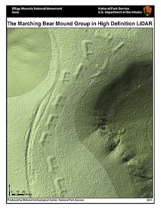
Lidar is a method for determining ranges by targeting an object or a surface with a laser and measuring the time for the reflected light to return to the receiver. LIDAR may operate in a fixed direction or it may scan multiple directions, in which case it is known as LIDAR scanning or 3D laser scanning, a special combination of 3-D scanning and laser scanning. LIDAR has terrestrial, airborne, and mobile applications.

<span class="mw-page-title-main">Remote sensing</span> Acquisition of information at a significant distance from the subject

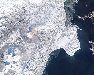
Remote sensing is the acquisition of information about an object or phenomenon without making physical contact with the object, in contrast to in situ or on-site observation. The term is applied especially to acquiring information about Earth and other planets. Remote sensing is used in numerous fields, including geophysics, geography, land surveying and most Earth science disciplines ; it also has military, intelligence, commercial, economic, planning, and humanitarian applications, among others.

<span class="mw-page-title-main">Landsat program</span> American network of Earth-observing satellites for international research purposes

The Landsat program is the longest-running enterprise for acquisition of satellite imagery of Earth. It is a joint NASA / USGS program. On 23 July 1972, the Earth Resources Technology Satellite was launched. This was eventually renamed to Landsat 1 in 1975. The most recent, Landsat 9, was launched on 27 September 2021.

<span class="mw-page-title-main">Moderate Resolution Imaging Spectroradiometer</span> Payload imaging sensor

The Moderate Resolution Imaging Spectroradiometer (MODIS) is a satellite-based sensor used for earth and climate measurements. There are two MODIS sensors in Earth orbit: one on board the Terra satellite, launched by NASA in 1999; and one on board the Aqua satellite, launched in 2002. MODIS has now been replaced by the VIIRS, which first launched in 2011 aboard the Suomi NPP satellite.

SeaWIFS was a satellite-borne sensor designed to collect global ocean biological data. Active from September 1997 to December 2010, its primary mission was to quantify chlorophyll produced by marine phytoplankton.

<span class="mw-page-title-main">Multispectral imaging</span> Capturing image data across multiple electromagnetic spectrum ranges

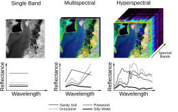
Multispectral imaging captures image data within specific wavelength ranges across the electromagnetic spectrum. The wavelengths may be separated by filters or detected with the use of instruments that are sensitive to particular wavelengths, including light from frequencies beyond the visible light range, i.e. infrared and ultra-violet. It can allow extraction of additional information the human eye fails to capture with its visible receptors for red, green and blue. It was originally developed for military target identification and reconnaissance. Early space-based imaging platforms incorporated multispectral imaging technology to map details of the Earth related to coastal boundaries, vegetation, and landforms. Multispectral imaging has also found use in document and painting analysis.

<span class="mw-page-title-main">MERIS</span>

MEdium Resolution Imaging Spectrometer (MERIS) was one of the main instruments on board the European Space Agency (ESA)'s Envisat platform. The sensor was in orbit from 2002 to 2012. ESA formally announced the end of Envisat's mission on 9 May 2012.

<span class="mw-page-title-main">Hyperspectral imaging</span> Multi-wavelength imaging method

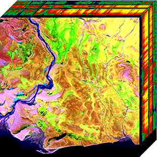
Hyperspectral imaging collects and processes information from across the electromagnetic spectrum. The goal of hyperspectral imaging is to obtain the spectrum for each pixel in the image of a scene, with the purpose of finding objects, identifying materials, or detecting processes. There are three general types of spectral imagers. There are push broom scanners and the related whisk broom scanners, which read images over time, band sequential scanners, which acquire images of an area at different wavelengths, and snapshot hyperspectral imagers, which uses a staring array to generate an image in an instant.

<span class="mw-page-title-main">Ocean color</span> Explanation of the color of oceans and ocean color remote sensing

Ocean color is the branch of ocean optics that specifically studies the color of the water and information that can be gained from looking at variations in color. The color of the ocean, while mainly blue, actually varies from blue to green or even yellow, brown or red in some cases. This field of study developed alongside water remote sensing, so it is focused mainly on how color is measured by instruments.

<span class="mw-page-title-main">VNIR</span> Portion of the electromagnetic spectrum between 400–1100 nm

The visible and near-infrared (VNIR) portion of the electromagnetic spectrum has wavelengths between approximately 400 and 1100 nanometers (nm). It combines the full visible spectrum with an adjacent portion of the infrared spectrum up to the water absorption band between 1400 and 1500 nm. Some definitions also include the short-wavelength infrared band from 1400 nm up to the water absorption band at 2500 nm. VNIR multi-spectral image cameras have wide applications in remote sensing and imaging spectroscopy. Hyperspectral Imaging Satellite carried two payloads, among which one was working on the spectral range of VNIR.

<span class="mw-page-title-main">Landsat 8</span> American Earth-observing satellite launched in 2013 as part of the Landsat program

Landsat 8 is an American Earth observation satellite launched on 11 February 2013. It is the eighth satellite in the Landsat program; the seventh to reach orbit successfully. Originally called the Landsat Data Continuity Mission (LDCM), it is a collaboration between NASA and the United States Geological Survey (USGS). NASA Goddard Space Flight Center in Greenbelt, Maryland, provided development, mission systems engineering, and acquisition of the launch vehicle while the USGS provided for development of the ground systems and will conduct on-going mission operations. It comprises the camera of the Operational Land Imager (OLI) and the Thermal Infrared Sensor (TIRS), which can be used to study Earth surface temperature and is used to study global warming.

<span class="mw-page-title-main">Sentinel-3</span> Earth observation satellite series

Sentinel-3 is an Earth observation heavy satellite series developed by the European Space Agency as part of the Copernicus Programme. It currently consists of 2 satellites: Sentinel-3A and Sentinel-3B. After initial commissioning, each satellite was handed over to EUMETSAT for the routine operations phase of the mission. Two recurrent satellites— Sentinel-3C and Sentinel-3D— will follow in approximately 2024 and 2028 respectively to ensure continuity of the Sentinel-3 mission.

<span class="mw-page-title-main">Mission Science Division</span>

The Earth and Mission Science Division is a group of European Space Agency (ESA) staff mission scientists, contractors, research fellows, young graduates, trainees, and administrative staff working within the Science, Applications and Climate Department of the Directorate of Earth Observation Programmes. The Division is located at ESA's European Space Research and Technology Centre in Noordwijk, South Holland, The Netherlands.

Sea ice concentration is a useful variable for climate scientists and nautical navigators. It is defined as the area of sea ice relative to the total at a given point in the ocean. This article will deal primarily with its determination from remote sensing measurements.

<span class="mw-page-title-main">GOES-16</span> American geosynchronous environmental satellite

<span class="mw-page-title-main">Gaofen</span> Chinese satellites

Gaofen is a series of Chinese high-resolution Earth imaging satellites launched as part of the China High-resolution Earth Observation System (CHEOS) program. CHEOS is a state-sponsored, civilian Earth-observation program used for agricultural, disaster, resource, and environmental monitoring. Proposed in 2006 and approved in 2010, the CHEOS program consists of the Gaofen series of space-based satellites, near-space and airborne systems such as airships and UAVs, ground systems that conduct data receipt, processing, calibration, and taskings, and a system of applications that fuse observation data with other sources to produce usable information and knowledge.

<span class="mw-page-title-main">Remote sensing (geology)</span> Data acquisition method for earth sciences

Remote sensing in geology is remote sensing used in the geological sciences as a data acquisition method complementary to field observation, because it allows mapping of geological characteristics of regions without physical contact with the areas being explored. About one-fourth of the Earth's total surface area is exposed land where information is ready to be extracted from detailed earth observation via remote sensing. Remote sensing is conducted via detection of electromagnetic radiation by sensors. The radiation can be naturally sourced, or produced by machines and reflected off of the Earth surface. The electromagnetic radiation acts as an information carrier for two main variables. First, the intensities of reflectance at different wavelengths are detected, and plotted on a spectral reflectance curve. This spectral fingerprint is governed by the physio-chemical properties of the surface of the target object and therefore helps mineral identification and hence geological mapping, for example by hyperspectral imaging. Second, the two-way travel time of radiation from and back to the sensor can calculate the distance in active remote sensing systems, for example, Interferometric synthetic-aperture radar. This helps geomorphological studies of ground motion, and thus can illuminate deformations associated with landslides, earthquakes, etc.

Remote sensing in oceanography is a widely used observational technique which enables researchers to acquire data of a location without physically measuring at that location. Remote sensing in oceanography mostly refers to measuring properties of the ocean surface with sensors on satellites or planes, which compose an image of captured electromagnetic radiation. A remote sensing instrument can either receive radiation from the earth’s surface (passive), whether reflected from the sun or emitted, or send out radiation to the surface and catch the reflection (active). All remote sensing instruments carry a sensor to capture the intensity of the radiation at specific wavelength windows, to retrieve a spectral signature for every location. The physical and chemical state of the surface determines the emissivity and reflectance for all bands in the electromagnetic spectrum, linking the measurements to physical properties of the surface. Unlike passive instruments, active remote sensing instruments also measure the two-way travel time of the signal; which is used to calculate the distance between the sensor and the imaged surface. Remote sensing satellites often carry other instruments which keep track of their location and measure atmospheric conditions.

Dorothy K. Hall is a scientific researcher known for her studies on snow and ice, which she studies through a combination of satellite data and direct measurements. She is a fellow of the American Geophysical Union.

<i>Earth Science Decadal Survey</i> Decadal science surveys

The Earth Science Decadal Survey is a publication of the United States National Research Council that identifies key research priorities in the field of Earth Sciences with a focus on remote sensing. It is written and released at the request of three United States government agencies: the National Aeronautics and Space Administration (NASA), the National Oceanic and Atmospheric Administration (NOAA) and the U.S. Geological Survey (USGS). The survey is produced by the Committee on the Decadal Survey for Earth Science and Applications from Space (ESAS) of the National Academies of Sciences, Engineering and Medicine (NASEM) Space Studies Board, Division on Engineering and Physical Sciences. Agencies like NASA use the recommendations from the decadal survey to prioritize funding for specific types of scientific research projects.

References

  1. Lucke, Robert L.; Corson, Michael; McGlothlin, Norman R.; Butcher, Steve D.; Wood, Daniel L.; Korwan, Daniel R.; Li, Rong R.; Snyder, Willliam A.; Davis, Curt O.; Chen, Davidson T. (1 March 2011). "Hyperspectral Imager for the Coastal Ocean: instrument description and first images". Applied Optics. The Optical Society. 50 (11): 1501–1516. Bibcode:2011ApOpt..50.1501L. doi:10.1364/ao.50.001501. ISSN   0003-6935. PMID   21478922.
  2. "HICO". NASA Ocean Color. 25 September 2009. Retrieved 21 September 2021.
  3. 1 2 3 "Mission Overview. What is HICO?". NASA Ocean Color. 10 September 2009. Retrieved 21 September 2021.
  4. "Bridging the Gap Between Theoretical and Practical". International Space Station U.S. National Laboratory. 20 October 2017. Retrieved 21 September 2021.
  5. Budzien, Scott (2009). "HICO and RAIDS Experiment Payload - Remote Atmospheric and Ionospheric Detection System (RAIDS)" (PDF). NASA Technical Reports Server (NTRS). Retrieved 22 September 2021.
  6. ""Sensing" a Change to Open Operations for Space Station's HICO Instrument". NASA. 9 July 2013. Retrieved 22 September 2021.
  7. Kelly, Nina Maggi (23 March 2015). "Satellites can be vulnerable to solar storms". IGIS Informatics and GIS. Agriculture and Natural Resources, University of California. Retrieved 22 September 2021.
  8. "SpaceX cargo capsule comes back to Earth from space station – Spaceflight Now". Spaceflight Now – The leading source for online space news. 3 August 2018. Retrieved 22 September 2021.
  9. 1 2 "Sensor and Data Characteristics". NASA Ocean Color. 10 September 2009. Retrieved 22 September 2021.
  10. "Space Station Orbit Tutorial". Gateway to Astronaut Photography of Earth. Retrieved 22 September 2021.
  11. Davis, Curtiss O. (2010). "The Hyperspectral Imager for the Coastal Ocean (HICO): Sensor and Data Processing Overview" (PDF). Index of Sensors. International Ocean Colour Coordinating Group (IOCCG). Retrieved 22 September 2021.
  12. "Coastal ocean sensing extended mission". NASA. 30 November 2015. Retrieved 22 September 2021.
  13. Alonso, Kevin; Bachmann, Martin; Burch, Kara; Carmona, Emiliano; Cerra, Daniele; de los Reyes, Raquel; Dietrich, Daniele; Heiden, Uta; Hölderlin, Andreas; Ickes, Jack; Knodt, Uwe; Krutz, David; Lester, Heath; Müller, Rupert; Pagnutti, Mary; Reinartz, Peter; Richter, Rudolf; Ryan, Robert; Sebastian, Ilse; Tegler, Mirco (15 October 2019). "Data Products, Quality and Validation of the DLR Earth Sensing Imaging Spectrometer (DESIS)". Sensors. MDPI AG. 19 (20): 4471. Bibcode:2019Senso..19.4471A. doi: 10.3390/s19204471 . ISSN   1424-8220. PMC   6848940 . PMID   31618940.
  14. Müller, R.; Avbelj, J.; Carmona, E.; Eckardt, A.; Gerasch, B.; Graham, L.; Günther, B.; Heiden, U.; Ickes, J.; Kerr, G.; Knodt, U.; Krutz, D.; Krawczyk, H.; Makarau, A.; Miller, R.; Perkins, R.; Walter, I. (3 June 2016). "The New Hyperspectral Sensor Desis on the Multi-Payload Platform Muses Installed on the Iss". ISPRS - International Archives of the Photogrammetry, Remote Sensing and Spatial Information Sciences. Copernicus GmbH. XLI-B1: 461–467. doi: 10.5194/isprsarchives-xli-b1-461-2016 . ISSN   2194-9034.
  15. Giardino, Claudia; Bresciani, Mariano; Braga, Federica; Fabbretto, Alice; Ghirardi, Nicola; Pepe, Monica; Gianinetto, Marco; Colombo, Roberto; Cogliati, Sergio; Ghebrehiwot, Semhar; Laanen, Marnix; Peters, Steef; Schroeder, Thomas; Concha, Javier A.; Brando, Vittorio E. (14 August 2020). "First Evaluation of PRISMA Level 1 Data for Water Applications". Sensors. MDPI AG. 20 (16): 4553. Bibcode:2020Senso..20.4553G. doi: 10.3390/s20164553 . hdl: 10281/282791 . ISSN   1424-8220. PMC   7471993 . PMID   32823847.
  16. Liu, Yin-Nian; Zhang, Jing; Zhang, Ying; Sun, Wei-Wei; Jiao, Lei-Lei; Sun, De-Xin; Hu, Xiao-Ning; Ye, Xiang; Li, Yun-Duan; Liu, Shu-Feng; Cao, Kai-Qin; Chai, Meng-Yang; Zhou, Wei-Yi-Nuo (2019). "The Advanced Hyperspectral Imager: Aboard China's GaoFen-5 Satellite". IEEE Geoscience and Remote Sensing Magazine. Institute of Electrical and Electronics Engineers (IEEE). 7 (4): 23–32. doi:10.1109/mgrs.2019.2927687. ISSN   2168-6831. S2CID   209457158.
  17. Esposito, M.; Zuccaro Marchi, A. (12 July 2019). "In-orbit demonstration of the first hyperspectral imager for nanosatellites". In Karafolas, Nikos; Sodnik, Zoran; Cugny, Bruno (eds.). International Conference on Space Optics — ICSO 2018. SPIE. p. 71. doi: 10.1117/12.2535991 . ISBN   9781510630772.
  18. "TSIS 1". Gunter's Space Page. Retrieved 23 September 2021.
  19. Hook, Simon (15 May 2019). "Instrument". ECOSTRESS. Retrieved 22 September 2021.
  20. Ryan, John; Davis, Curtiss; Tufillaro, Nicholas; Kudela, Raphael; Gao, Bo-Cai (27 January 2014). "Application of the Hyperspectral Imager for the Coastal Ocean to Phytoplankton Ecology Studies in Monterey Bay, CA, USA". Remote Sensing. MDPI AG. 6 (2): 1007–1025. Bibcode:2014RemS....6.1007R. doi: 10.3390/rs6021007 . ISSN   2072-4292.
  21. O'Shea, Ryan E.; Pahlevan, Nima; Smith, Brandon; Bresciani, Mariano; Egerton, Todd; Giardino, Claudia; Li, Lin; Moore, Tim; Ruiz-Verdu, Antonio; Ruberg, Steve; Simis, Stefan G.H.; Stumpf, Richard; Vaičiūtė, Diana (2021). "Advancing cyanobacteria biomass estimation from hyperspectral observations: Demonstrations with HICO and PRISMA imagery". Remote Sensing of Environment. Elsevier BV. 266: 112693. Bibcode:2021RSEnv.266k2693O. doi: 10.1016/j.rse.2021.112693 . hdl: 1805/31613 . ISSN   0034-4257.
  22. Kudela, Raphael M.; Palacios, Sherry L.; Austerberry, David C.; Accorsi, Emma K.; Guild, Liane S.; Torres-Perez, Juan (2015). "Application of hyperspectral remote sensing to cyanobacterial blooms in inland waters". Remote Sensing of Environment. Elsevier BV. 167: 196–205. Bibcode:2015RSEnv.167..196K. doi: 10.1016/j.rse.2015.01.025 . ISSN   0034-4257.
  23. Dierssen, Heidi; McManus, George B.; Chlus, Adam; Qiu, Dajun; Gao, Bo-Cai; Lin, Senjie (16 November 2015). "Space station image captures a red tide ciliate bloom at high spectral and spatial resolution". Proceedings of the National Academy of Sciences. 112 (48): 14783–14787. Bibcode:2015PNAS..11214783D. doi: 10.1073/pnas.1512538112 . ISSN   0027-8424. PMC   4672822 . PMID   26627232.
  24. Garcia, Rodrigo A.; Fearns, Peter R.C.S.; McKinna, Lachlan I.W. (2014). "Detecting trend and seasonal changes in bathymetry derived from HICO imagery: A case study of Shark Bay, Western Australia". Remote Sensing of Environment. Elsevier BV. 147: 186–205. Bibcode:2014RSEnv.147..186G. doi:10.1016/j.rse.2014.03.010. hdl: 20.500.11937/24033 . ISSN   0034-4257.
  25. Lewis, David; Gould, Richard W.; Weidemann, Alan; Ladner, Sherwin; Lee, Zhongping (3 June 2013). "Bathymetry estimations using vicariously calibrated HICO data". In Hou, Weilin W.; Arnone, Robert A. (eds.). Ocean Sensing and Monitoring V. Vol. 8724. SPIE. pp. 87240N. doi:10.1117/12.2017864.
  26. Cao, Fang; Mishra, Deepak R.; Schalles, John F.; Miller, William L. (2018). "Evaluating ultraviolet (UV) based photochemistry in optically complex coastal waters using the Hyperspectral Imager for the Coastal Ocean (HICO)". Estuarine, Coastal and Shelf Science. Elsevier BV. 215: 199–206. Bibcode:2018ECSS..215..199C. doi: 10.1016/j.ecss.2018.10.013 . ISSN   0272-7714.
  27. Braga, Federica; Giardino, Claudia; Bassani, Cristiana; Matta, Erica; Candiani, Gabriele; Strömbeck, Niklas; Adamo, Maria; Bresciani, Mariano (2013). "Assessing water quality in the northern Adriatic Sea from HICO™ data". Remote Sensing Letters. Informa UK Limited. 4 (10): 1028–1037. doi:10.1080/2150704x.2013.830203. ISSN   2150-704X. S2CID   122545559.
  28. Bachmann, Charles M.; Nichols, C. Reid.; Montes, Marcos J.; Fusina, Robert A.; Fry, John C.; Li, Rong-Rong; Gray, Deric; Korwan, Daniel; Parrish, Christopher; Sellars, Jon; White, Stephen A.; Woolard, Jason; Lee, Krista; McConnon, Cecilia; Wende, Jon (2010). "Coastal Characterization from Hyperspectral Imagery". Imaging and Applied Optics Congress. Washington, D.C.: OSA. pp. OMD2. doi:10.1364/orse.2010.omd2. ISBN   978-1-55752-892-6.
  29. Leifer, Ira; Lehr, William J.; Simecek-Beatty, Debra; Bradley, Eliza; Clark, Roger; Dennison, Philip; Hu, Yongxiang; Matheson, Scott; Jones, Cathleen E.; Holt, Benjamin; Reif, Molly; Roberts, Dar A.; Svejkovsky, Jan; Swayze, Gregg; Wozencraft, Jennifer (2012). "State of the art satellite and airborne marine oil spill remote sensing: Application to the BP Deepwater Horizon oil spill". Remote Sensing of Environment. Elsevier BV. 124: 185–209. Bibcode:2012RSEnv.124..185L. doi:10.1016/j.rse.2012.03.024. ISSN   0034-4257.