King's Lynn and West Norfolk

Last updated

Borough of King's Lynn and West Norfolk
Kings Lynn (14584250917).jpg
King's Lynn, known for both King's Lynn Minster and a statue to George Vancouver. The town is the administrative centre and largest settlement in the borough.
King's Lynn and West Norfolk UK locator map.svg
Shown within Norfolk
Sovereign state United Kingdom
Constituent country England
Region East of England
Administrative county Norfolk
Admin. HQ King's Lynn
Government
  TypeBorough Council
   MPs: James Wild (C)
Liz Truss (C)
Area
  Total560 sq mi (1,440 km2)
  Rank 15th
Population
 (2021)
  Total154,910
  Rank Ranked 136th
  Density280/sq mi (110/km2)
Ethnicity (2021)
[1]
   Ethnic groups
List
Religion (2021)
[1]
   Religion
List
Time zone UTC+0 (Greenwich Mean Time)
  Summer (DST) UTC+1 (British Summer Time)
ONS code 33UE (ONS)
E07000146 (GSS)

King's Lynn and West Norfolk is a local government district with borough status in Norfolk, England. Its council is based in the town of King's Lynn. The district also includes the towns of Downham Market and Hunstanton, along with numerous villages and surrounding rural areas. The population of the district at the 2021 census was 154,325. [2]

Contents

Part of the borough lies within the Norfolk Coast Area of Outstanding Natural Beauty. The borough lies on the coast, facing both The Wash to the west and the North Sea to the north. The neighbouring districts are North Norfolk, Breckland, West Suffolk, East Cambridgeshire, Fenland and South Holland.

History

The district was created on 1 April 1974 under the Local Government Act 1972, covering seven former districts which were all abolished at the same time: [3]

The new district was initially named "West Norfolk" reflecting its position in the wider county. [4] The district was awarded borough status on 30 January 1981, allowing the chair of the council to take the title of mayor. The name of the borough was changed later that year, becoming "King's Lynn and West Norfolk" with effect from 14 May 1981. [5]

Governance

Borough Council of King's Lynn and West Norfolk
Borough Council of King's Lynn and West Norfolk logo.svg
Type
Type
Leadership
Margaret Wilkinson,
Labour
since 18 May 2023 [6]
Terry Parish,
Independent
since 18 May 2023
Lorraine Gore
since 1 September 2019 [7]
Structure
Seats55 councillors
Political groups
Administration (22)
  Independent (17)
  Liberal Democrats (3)
  Green (2)
Other parties (32)
  Conservative (21)
  Labour (11)
  Independent (1)
Elections
Last election
4 May 2023
Next election
6 May 2027
Meeting place
Kings Lynn Guild Hall (geograph 4626827).jpg
Town Hall, Saturday Market Place, King's Lynn, PE30 5DQ
Website
www.west-norfolk.gov.uk

The Borough Council of King's Lynn and West Norfolk provides district-level services. County-level services are provided by Norfolk County Council. Much of the borough is also covered by civil parishes, which form a third tier of local government. [8] [9]

Political control

The council has been under no overall control since the 2023 election, being run by a coalition of most of the independent councillors, the Liberal Democrats and the Greens with informal support from Labour. [10]

The first election to the council was held in 1973, initially operating as a shadow authority alongside the outgoing authorities until the new arrangements took effect on 1 April 1974. Political control of the council since 1974 has been as follows: [11] [12]

Party in controlYears
No overall control 1974–1976
Conservative 1976–1991
No overall control 1991–1995
Labour 1995–1999
No overall control 1999–2003
Conservative 2003–2023
No overall control 2023–present

Leadership

The role of mayor is largely ceremonial in King's Lynn and West Norfolk, with political leadership instead provided by the leader of the council. The leaders since 2007 have been: [13]

CouncillorPartyFromTo
Nick Daubney [14] Conservative 200712 May 2016
Brian Long [15] Conservative 12 May 201620 May 2021
Stuart Dark Conservative 20 May 202118 May 2023
Terry Parish Independent 18 May 2023

Composition

Following the 2023 election the composition of the council was: [16]

PartyCouncillors
Conservative 21
Independent 18
Labour 11
Liberal Democrats 3
Green 2
Total55

Of the independent councillors, 17 sit together as the "Independent Partnership", which forms the council's administration with the Liberal Democrats and Greens. [17] The next election is due in 2027.

Elections

Since the last boundary changes in 2019 the council has comprised 55 councillors representing 35 wards, with each ward electing one, two or three councillors. Elections are held every four years. [18]

UK Youth Parliament

Although the UK Youth Parliament is an apolitical organisation, the elections are run in a way similar to that of the Local Elections. The votes come from 11 to 18 year olds and are combined to make the decision of the next, 2 year Member of Youth Parliament. The elections are run at different times across the country with King's Lynn and West Norfolk's typically being in early Spring and bi-annually.

Premises

The council generally meets at the Town Hall on the Saturday Market Place in King's Lynn, parts of which date back to the 1420s, having replaced an earlier guildhall on the site which burnt down in 1421. [19] [20] The council's main offices are at King's Court, on Chapel Street in King's Lynn, which had been built as speculative offices in 1975, initially being called Aspen House. [21] The council bought the building in 1981. [22]

Geography

Hunstanton, one of the coastal towns on the Norfolk Coast. The seafront at Hunstanton - geograph.org.uk - 2793449.jpg
Hunstanton, one of the coastal towns on the Norfolk Coast.

The district comprises the urban area of King's Lynn itself, together with 102 surrounding parishes. At the time of the 2001 census, the district had an area of 1,473 km², of which 28 km² was in the urban area and 1,445 km² in the surrounding parishes. The district had a population of 135,345 in 58,338 households, with 34,564 in 15,285 households living in the urban area, whilst 100,781 people in 43,053 households lived in the surrounding parishes. [23]

Towns and parishes

The main part of the urban area of King's Lynn (roughly corresponding to the pre-1974 borough of King's Lynn) is an unparished area. [9] The remainder of the district is covered by civil parishes. The parish councils for Downham Market and Hunstanton have declared their parishes to be towns, allowing them to take the style "town council". The parishes are: [24]

Arms

Coat of arms of King's Lynn and West Norfolk
Crest
Upon a wreath Or and Azure upon a bollard Sable roped Or a seagull Proper gorged with a coronet and holding in the dexter claw a cross botonny fitchy Or.
Escutcheon
Per chevron Azure and Or three dragons' heads erect and erased each transfixed through the mouth by a cross botonny fitchy all within a bordure per chevron counter-changed.
Supporters
On either side a sea lion Or supporting with the exterior leg an ostrich feather Argent. [25]
Badge
A sea lion Or within a garland of oakleaves fructed Proper.

Related Research Articles

<span class="mw-page-title-main">North Norfolk</span> District in Norfolk, England

North Norfolk is a local government district in Norfolk, England. Its council is based in Cromer, and the largest town is North Walsham. The district also includes the towns of Fakenham, Holt, Sheringham, Stalham and Wells-next-the-Sea, along with numerous villages and surrounding rural areas.

<span class="mw-page-title-main">Downham Market</span> Market town in Norfolk, England

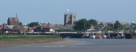
Downham Market, sometimes simply referred to as Downham, is a market town and civil parish in Norfolk, England. It lies on the edge of the Fens, on the River Great Ouse, approximately 11 miles south of King's Lynn, 39 miles west of Norwich and 30 miles north of Cambridge.

<span class="mw-page-title-main">South West Norfolk (UK Parliament constituency)</span> Parliamentary constituency in the United Kingdom, 1885 onwards

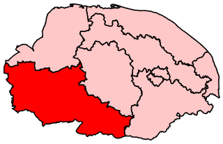
South West Norfolk is a constituency represented in the House of Commons of the UK Parliament since 2010 by Liz Truss of the Conservative Party, who briefly served as Prime Minister of the United Kingdom from September to October 2022.

<span class="mw-page-title-main">North West Norfolk (UK Parliament constituency)</span> Parliamentary constituency in the United Kingdom 1885-1918 & since 1974

North West Norfolk is a constituency represented in the House of Commons of the UK Parliament since 2019 by James Wild, a Conservative.

<span class="mw-page-title-main">Burnham Market</span> Coastal village in Norfolk, England

Burnham Market is an English village and civil parish near the north coast of Norfolk. It is one of the Burnhams, a group of three adjacent villages that were merged: Burnham Sutton, Burnham Ulph and Burnham Westgate. In 2022, Burnham Market was rated among the "20 most beautiful villages in the UK and Ireland" by Condé Nast Traveler in 2020.

<span class="mw-page-title-main">North Creake</span> Human settlement in England

North Creake is a village and civil parish in the north west of the English county of Norfolk. It covers an area of 14.99 km2 (5.79 sq mi) and had a population of 414 in 184 households at the 2001 census, reducing to 386 at the 2011 Census. For the purposes of local government, it falls within the district of King's Lynn and West Norfolk. The parish shares boundaries with the adjacent parishes of Burnham Market, Burnham Thorpe, Holkham, Walsingham, South Creake, Barwick and Stanhoe.

<span class="mw-page-title-main">West Lynn, Norfolk</span> Human settlement in England

West Lynn is a suburb of King's Lynn in Norfolk, England. It is the part of the town lying on the west bank of the River Great Ouse, linked to the main part of the town on the east bank by a passenger ferry or by a more circuitous 4 km road journey.

<span class="mw-page-title-main">Burnham Norton</span> Village in Norfolk, England

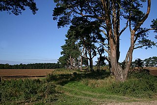
Burnham Norton is a village and civil parish in the English county of Norfolk, one of the Burnhams, an adjacent group in the northernmost part of Norfolk, on the A149 some 2 km north of the larger village of Burnham Market, 35 km north-east of King's Lynn and 60 km north-west of Norwich. "Burnham" means "Homestead/village on the River Burn" or perhaps, "hemmed-in land on the River Burn". "Norton", meaning "North farm/settlement", distinguishes it from the other Norfolk Burnhams.

King's Lynn and West Norfolk District Council in Norfolk, England is elected every four years. Since the last boundary changes in 2019, 55 councillors have been elected from 35 wards.

King's Lynn was a constituency in Norfolk which was represented continuously in the House of Commons of England from 1298 to 1707, in the House of Commons of Great Britain from 1707 to 1800, and in the House of Commons of the United Kingdom from 1801 until it was abolished for the February 1974 general election.

West Rudham is a civil parish in the English county of Norfolk. The village straddles the A148 King's Lynn to Cromer road. It covers an area of 11.81 km2 (4.56 sq mi) and had a population of 213 in 97 households at the 2001 census, the population including Houghton and increasing to 288 at the 2011 census. For the purposes of local government, it falls within the district of King's Lynn and West Norfolk.

<span class="mw-page-title-main">Stradsett</span> Human settlement in England

Stradsett is a village and civil parish in the English county of Norfolk The village is 40.8 miles (65.7 km) west of Norwich, 11.3 miles (18.2 km) south of King's Lynn and 96.4 miles (155.1 km) north of London. The nearest town is Downham Market which is 3.5 miles (5.6 km) west of the parish. The village is located on the A1122 which runs between Outwell and Swaffham. The A134 between King's Lynn and Colchester also passes through the parish. The nearest railway station is at Downham Market for the Fen Line which runs between King's Lynn and Cambridge. The nearest airport is Norwich International Airport. The parish of Stradsett, in the 2001 census, has a population of 60. For the purposes of local government, the parish falls within the district of King's Lynn and West Norfolk. At the 2011 Census the population remained less than 100 and was included in the civil parish of Crimplesham.

<span class="mw-page-title-main">Houghton, Norfolk</span> Village in Norfolk, England

Houghton is a small village and a civil parish in the English county of Norfolk. It covers an area of 7.64 km2 (2.95 sq mi) and had a population of 69 in 36 households at the 2001 census. At the 2011 census the population of the parish was again below 100, and was therefore included in the civil parish of West Rudham.

<span class="mw-page-title-main">Shouldham</span> Human settlement in England

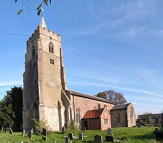
Shouldham is a village and civil parish in the English county of Norfolk. It covers an area of 16.04 km2 (6.19 sq mi) and had a population of 608 in 246 households at the 2001 census, the population reducing slightly to 605 at the 2011 census. It also contains a church (pictured) and a primary school.

<span class="mw-page-title-main">Wiggenhall St Mary Magdalen</span> Human settlement in England

Wiggenhall St Mary Magdalen is a civil parish and village in the English county of Norfolk. It is 6 miles (9.7 km) south of the town of King's Lynn on the west bank of the River Great Ouse. It covers an area of 17.76 km2 (6.86 sq mi) and had a population of 729 in 304 households in the 2011 census. For the purposes of local government, it falls within the district of King's Lynn and West Norfolk.

<span class="mw-page-title-main">Stowbridge</span>

Stowbridge or Stow Bridge is a village in the parish of Stow Bardolph, extending into Wiggenhall St Mary Magdalen, in the English county of Norfolk. The parish of Stow Bardolph also includes Barroway Drove. Stowbridge is between Downham Market and King's Lynn on the banks of the River Great Ouse. For the purposes of local government, it falls within the district of King's Lynn and West Norfolk. The Great Ouse, the Relief Channel and the mainline railway from King's Lynn to Cambridge run through the heart of the community.

<span class="mw-page-title-main">West Suffolk District</span> Non-metropolitan district in England

West Suffolk District is a local government district in Suffolk, England. It was established in 2019 as a merger of the previous Forest Heath District with the Borough of St Edmundsbury. The council is based in Bury St Edmunds, the district's largest town. The district also contains the towns of Brandon, Clare, Haverhill, Mildenhall and Newmarket, along with numerous villages and surrounding rural areas. In 2021 it had a population of 180,820.

References

  1. 1 2 UK Census (2021). "2021 Census Area Profile – King's Lynn and West Norfolk Local Authority (E07000146)". Nomis. Office for National Statistics . Retrieved 5 January 2024.
  2. "How the population changed in King's Lynn and West Norfolk: Census 2021". ONS. Office for National Statistics. 28 June 2022. Retrieved 28 August 2023.
  3. "The English Non-metropolitan District (Definition) Order 1972", legislation.gov.uk , The National Archives, SI 1972/2039, retrieved 17 November 2023
  4. "The English Non-metropolitan Districts (Names) Order 1973", legislation.gov.uk , The National Archives, SI 1973/551, retrieved 31 May 2023
  5. Alteration of Areas and Status of Local Authorities 1980–1982 (PDF). London: Department of the Environment. 1982. pp. 9–10. Retrieved 8 December 2023.
  6. "Council minutes, 18 May 2023". Borough Council of King's Lynn and West Norfolk. Retrieved 8 December 2023.
  7. "New Chief Executive announced". Borough Council of King's Lynn and West Norfolk. 30 July 2019. Retrieved 8 December 2023.
  8. "Local Government Act 1972", legislation.gov.uk , The National Archives, 1972 c. 70, retrieved 31 May 2023
  9. 1 2 "Election Maps". Ordnance Survey. Retrieved 21 September 2023.
  10. Johnston, Kris (19 May 2023). "Independent councillor Terry Parish named new leader of West Norfolk Council at 2023 annual meeting". Lynn News. Retrieved 6 December 2023.
  11. "Compositions calculator". The Elections Centre. 4 March 2016. Retrieved 1 June 2023.
  12. "King's Lynn & West Norfolk". BBC News Online . Retrieved 26 September 2009.
  13. "Council minutes". King's Lynn and West Norfolk Borough Council. Retrieved 24 June 2022.
  14. Ali, Taz (11 May 2018). "Former council leader becomes new mayor of West Norfolk". Eastern Daily Press. Retrieved 24 June 2022.
  15. Bishop, Chris (11 May 2021). "New leader for West Norfolk council". Eastern Daily Press. Retrieved 24 June 2022.
  16. "Local elections 2023: live council results for England". The Guardian.
  17. "Your councillors by party". Borough Council of King's Lynn and West Norfolk. Retrieved 8 December 2023.
  18. "The King's Lynn and West Norfolk (Electoral Changes) Order 2018", legislation.gov.uk , The National Archives, SI 2018/857, retrieved 8 December 2023
  19. Historic England. "Guildhall, King's Lynn (1211953)". National Heritage List for England . Retrieved 25 August 2019.
  20. McAvoy, Liz Herbert (2003). The Book of Margery Kempe. D.S.Brewer. p. 79. ISBN   978-0859917919.
  21. "Topping-out for Lynn office block". Lynn News and Advertiser. 11 February 1975. p. 11. Retrieved 9 December 2023.
  22. "Council moves to £¾m new hq". Lynn News and Advertiser. 21 August 1981. p. 1. Retrieved 8 December 2023.
  23. Office for National Statistics & Norfolk County Council (2001). Census population and household counts for unparished urban areas and all parishes Archived 2017-02-11 at the Wayback Machine . Retrieved December 2, 2005.
  24. "Parish council contact details". Borough Council of King's Lynn and West Norfolk. Retrieved 8 December 2023.
  25. "East of England Region". Civic Heraldry of England. Retrieved 9 March 2021.

52°45′18″N0°23′46″E / 52.7549°N 0.3962°E / 52.7549; 0.3962