Laccolith

Last updated
Cross section of a laccolith intruding into and deforming strata Laccolith.svg
Cross section of a laccolith intruding into and deforming strata

A laccolith is a body of intrusive rock with a dome-shaped upper surface and a level base, fed by a conduit from below. A laccolith forms when magma (molten rock) rising through the Earth's crust begins to spread out horizontally, prying apart the host rock strata. The pressure of the magma is high enough that the overlying strata are forced upward, giving the laccolith its dome-like form.

Contents

Over time, erosion can expose the solidified laccolith, which is typically more resistant to weathering than the host rock. The exposed laccolith then forms a hill or mountain. The Henry Mountains of Utah, US, are an example of a mountain range composed of exposed laccoliths. It was here that geologist Grove Karl Gilbert carried out pioneering field work on this type of intrusion. Laccolith mountains have since been identified in many other parts of the world.

Basic types of intrusions:
1. Laccolith
2. Small dike
3. Batholith
4. Dike
5. Sill
6. Volcanic neck, pipe
7. Lopolith
Note: As a general rule, in contrast to the smoldering volcanic vent in the figure, these names refer to the fully cooled and usually millions-of-years-old rock formations, which are the result of the underground magmatic activity shown. Intrusion types.svg
Basic types of intrusions:
1. Laccolith
2. Small dike
3. Batholith
4. Dike
5. Sill
6. Volcanic neck, pipe
7. Lopolith
Note: As a general rule, in contrast to the smoldering volcanic vent in the figure, these names refer to the fully cooled and usually millions-of-years-old rock formations, which are the result of the underground magmatic activity shown.

Description

A laccolith is a type of igneous intrusion, formed when magma forces its way upwards through the Earth's crust but cools and solidifies before reaching the surface. Laccoliths are distinguished from other igneous intrusions by their dome-shaped upper surface and level base. They are assumed to be fed by a conduit from below, though this is rarely exposed. [1] [2] When the host rock is volcanic, the laccolith is referred to as a cryptodome. [3] Laccoliths form only at relatively shallow depth in the crust, [4] usually from intermediate composition magma, though laccoliths of all compositions from silica-poor basalt to silica-rich rhyolite are known. [5]

A laccolith forms after an initial sheet-like intrusion has been injected between layers of sedimentary rock. If the intrusion remains limited in size, it forms a sill, in which the strata above and below the intrusion remain parallel to each other and the intrusion remains sheetlike. The intrusion begins to lift and dome the overlying strata only if the radius of the intrusion exceeds a critical radius, which is roughly: [6]

where is the pressure of the magma, is the lithostatic pressure (weight of the overlying rock), is the thickness of the overlying rocks, and is the shear strength of the overlying rock. For example, in the Henry Mountains of Utah, US, the geologist Grove Karl Gilbert found in 1877 that sills were always less than 1 square kilometer (0.4 sq mi) in area while laccoliths were always greater than 1 square kilometer in area. From this, Gilbert concluded that sills were forerunners of laccoliths. Laccoliths formed from sills only when they became large enough for the pressure of the magma to force the overlying strata to dome upwards. Gilbert also determined that larger laccoliths formed at greater depth. [1] Both laccoliths and sills are classified as concordant intrusions, since the bulk of the intrusion does not cut across host rock strata, but intrudes between strata. [7]

More recent study of laccoliths has confirmed Gilbert's basic conclusions, while refining the details. Both sills and laccoliths have blunt rather than wedgelike edges, and sills of the Henry Mountains are typically up to 10 meters (33 ft) thick while laccoliths are up to 200 meters (660 ft) thick. [8] The periphery of a laccolith may be smooth, but it may also have fingerlike projections consistent with Rayleigh-Taylor instability of the magma pushing along the strata. [9] An example of a fingered laccolith is the Shonkin Sag laccolith in Montana, US. [4] The critical radius for the sill to laccolith transition is now thought to be affected the viscosity of the magma (being greater for less viscous magma) as well as the strength of the host rock. A modern formula for the shape of a laccolith is:

Idealized laccolith shape Laccolith shape.jpg
Idealized laccolith shape

where is the height of the laccolith roof, is the acceleration of gravity, is the elastic modulus of the host rock, is the horizontal distance from the center of the laccolith, and is the outer radius of the laccolith. [4] Because of their greater thickness, which slows the cooling rate, the rock of laccoliths is usually coarser-grained than the rock of sills. [5]

The growth of laccoliths can take as little as a few months when associated with a single magma injection event, [10] [11] or up to hundreds or thousands of years by multiple magmatic pulses stacking sills on top of each other and deforming the host rock incrementally. [12]

Over time, erosion can form small hills and even mountains around a central peak since the intrusive rock is usually more resistant to weathering than the host rock. [13] Because the emplacement of the laccolith domes up the overlying beds, local topographic relief is increased and erosion is accelerated, so that the overlying beds are eroded away to expose the intrusive cores. [14]

Etymology

The term was first applied as laccolite by Gilbert after his study of intrusions of diorite in the Henry Mountains of Utah in about 1875. [15] [16] The word laccolith was derived in 18751880, from Greek lákko(s) 'pond' plus -lith 'stone'. [17]

Where laccoliths form

Laccoliths tend to form at relatively shallow depths and in some cases are formed by relatively viscous magmas, such as those that crystallize to diorite, granodiorite, and granite. In those cases cooling underground may take place slowly, giving time for larger crystals to form in the cooling magma. In other cases less viscous magma such as shonkinite may form phenocrysts of augite at depth, then inject through a vertical feeder dike that ends in a laccolith. [18]

Sheet intrusions tend to form perpendicular to the direction of least stress in the country rock they intrude. Thus laccoliths are characteristic of regions where the crust is being compressed and the direction of least stress is vertical, while areas where the crust is in tension are more likely to form dikes, since the direction of least stress is then horizontal. For example, the laccoliths of the Ortiz porphyry belt in New Mexico likely formed during Laramide compression of the region 33 to 36 million years ago. When Laramide compression was later replaced by extension, emplacement of sills and laccoliths was replaced by emplacement of dikes. Dating of the intrusions has helped determine the point in geologic time when compression was replaced with extension. [19]

Examples

In addition to the Henry Mountains, laccolith mountains are found on the nearby Colorado Plateau in the La Sal Mountains and Abajo Mountains. [14]

The filled and solidified magma chamber of Torres del Paine (Patagonia) is one of the best exposed laccoliths, built up incrementally by horizontal granitic and mafic magma intrusions over 162 ± 11 thousand years. [20] Horizontal sheeted intrusions were fed by vertical intrusions. [21]

The small Barber Hill syenite-stock laccolith in Charlotte, Vermont, has several volcanic trachyte dikes associated with it. Molybdenite is also visible in outcrops on this exposed laccolith. In Big Bend Ranch State Park, at the southwesternmost visible extent of the Ouachita orogeny, lies the Solitario. [22] It consists of the eroded remains of a laccolith, presumably named for the sense of solitude that observers within the structure might have, due to the partial illusion of endless expanse in all directions. [22]

One of the largest laccoliths in the United States is Pine Valley Mountain in the Pine Valley Mountain Wilderness area near St. George, Utah. [23]

A system of laccoliths is exposed on the Italian island of Elba, which form a "Christmas tree" laccolith system in which a single igneous plumbing system has produced multiple laccoliths at different levels in the crust. [24]

Problems reconstructing shapes of intrusions

The original shape of intrusions can be difficult to reconstruct. For instance, Devils Tower in Wyoming and Needle Rock in Colorado were both thought to be volcanic necks, but further study has suggested they are eroded laccoliths. [25] [26] At Devils Tower, intrusion would have had to cool very slowly so as to form the slender pencil-shaped columns of phonolite porphyry seen today. However, erosion has stripped away the overlying and surrounding rock, so it is impossible to reconstruct the original shape of the igneous intrusion, which may or may not be the remnant of a laccolith. At other localities, such as in the Henry Mountains and other isolated mountain ranges of the Colorado Plateau, some intrusions demonstrably have the classic shapes of laccoliths. [27]

Extraterrestrial laccoliths

There are many examples of possible laccoliths on the surface of the Moon. Some are centered in impact craters and may form as part of the post-impact evolution of the crater. [28] Others are located along possible faults or fissures. [29] Laccoliths on the Moon are much wider but less thick than those on Earth, due to the Moon's lower gravity and more fluid magmatism. [30]

Possible laccoliths have also been identified on Mars, in western Arcadia Planitia. [31]

See also

Related Research Articles

<span class="mw-page-title-main">Granite</span> Type of igneous rock

Granite is a coarse-grained (phaneritic) intrusive igneous rock composed mostly of quartz, alkali feldspar, and plagioclase. It forms from magma with a high content of silica and alkali metal oxides that slowly cools and solidifies underground. It is common in the continental crust of Earth, where it is found in igneous intrusions. These range in size from dikes only a few centimeters across to batholiths exposed over hundreds of square kilometers.

<span class="mw-page-title-main">Gabbro</span> Coarse-grained mafic intrusive rock

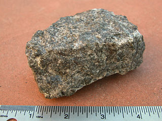
Gabbro is a phaneritic (coarse-grained), mafic intrusive igneous rock formed from the slow cooling of magnesium-rich and iron-rich magma into a holocrystalline mass deep beneath the Earth's surface. Slow-cooling, coarse-grained gabbro is chemically equivalent to rapid-cooling, fine-grained basalt. Much of the Earth's oceanic crust is made of gabbro, formed at mid-ocean ridges. Gabbro is also found as plutons associated with continental volcanism. Due to its variant nature, the term gabbro may be applied loosely to a wide range of intrusive rocks, many of which are merely "gabbroic". By rough analogy, gabbro is to basalt as granite is to rhyolite.

<span class="mw-page-title-main">Magma</span> Hot semifluid material found beneath the surface of Earth

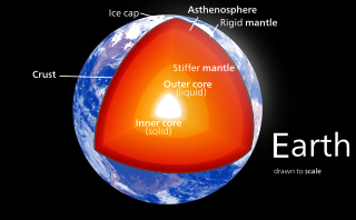
Magma is the molten or semi-molten natural material from which all igneous rocks are formed. Magma is found beneath the surface of the Earth, and evidence of magmatism has also been discovered on other terrestrial planets and some natural satellites. Besides molten rock, magma may also contain suspended crystals and gas bubbles.

<span class="mw-page-title-main">Batholith</span> Large igneous rock intrusion

A batholith is a large mass of intrusive igneous rock, larger than 100 km2 (40 sq mi) in area, that forms from cooled magma deep in Earth's crust. Batholiths are almost always made mostly of felsic or intermediate rock types, such as granite, quartz monzonite, or diorite.

<span class="mw-page-title-main">Rhyolite</span> Igneous, volcanic rock, of felsic (silica-rich) composition

Rhyolite is the most silica-rich of volcanic rocks. It is generally glassy or fine-grained (aphanitic) in texture, but may be porphyritic, containing larger mineral crystals (phenocrysts) in an otherwise fine-grained groundmass. The mineral assemblage is predominantly quartz, sanidine, and plagioclase. It is the extrusive equivalent of granite.

<span class="mw-page-title-main">Andesite</span> Type of volcanic rock

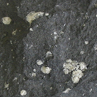
Andesite is a volcanic rock of intermediate composition. In a general sense, it is the intermediate type between silica-poor basalt and silica-rich rhyolite. It is fine-grained (aphanitic) to porphyritic in texture, and is composed predominantly of sodium-rich plagioclase plus pyroxene or hornblende.

<span class="mw-page-title-main">Magma chamber</span> Accumulation of molten rock within the Earths crust

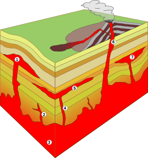
A magma chamber is a large pool of liquid rock beneath the surface of the Earth. The molten rock, or magma, in such a chamber is less dense than the surrounding country rock, which produces buoyant forces on the magma that tend to drive it upwards. If the magma finds a path to the surface, then the result will be a volcanic eruption; consequently, many volcanoes are situated over magma chambers. These chambers are hard to detect deep within the Earth, and therefore most of those known are close to the surface, commonly between 1 km and 10 km down.

<span class="mw-page-title-main">Peridotite</span> Coarse-grained ultramafic igneous rock type

Peridotite ( PERR-ih-doh-tyte, pə-RID-ə-) is a dense, coarse-grained igneous rock consisting mostly of the silicate minerals olivine and pyroxene. Peridotite is ultramafic, as the rock contains less than 45% silica. It is high in magnesium (Mg2+), reflecting the high proportions of magnesium-rich olivine, with appreciable iron. Peridotite is derived from Earth's mantle, either as solid blocks and fragments, or as crystals accumulated from magmas that formed in the mantle. The compositions of peridotites from these layered igneous complexes vary widely, reflecting the relative proportions of pyroxenes, chromite, plagioclase, and amphibole.

<span class="mw-page-title-main">Dike (geology)</span> A sheet of rock that is formed in a fracture of a pre-existing rock body

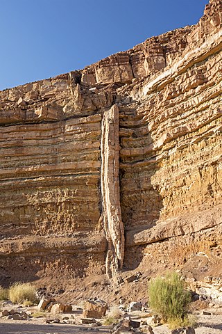
In geology, a dike or dyke is a sheet of rock that is formed in a fracture of a pre-existing rock body. Dikes can be either magmatic or sedimentary in origin. Magmatic dikes form when magma flows into a crack then solidifies as a sheet intrusion, either cutting across layers of rock or through a contiguous mass of rock. Clastic dikes are formed when sediment fills a pre-existing crack.

<span class="mw-page-title-main">Flood basalt</span> Very large volume eruption of basalt lava

A flood basalt is the result of a giant volcanic eruption or series of eruptions that covers large stretches of land or the ocean floor with basalt lava. Many flood basalts have been attributed to the onset of a hotspot reaching the surface of the Earth via a mantle plume. Flood basalt provinces such as the Deccan Traps of India are often called traps, after the Swedish word trappa, due to the characteristic stairstep geomorphology of many associated landscapes.

<span class="mw-page-title-main">Sill (geology)</span> Tabular intrusion between older layers of rock

In geology, a sill is a tabular sheet intrusion that has intruded between older layers of sedimentary rock, beds of volcanic lava or tuff, or along the direction of foliation in metamorphic rock. A sill is a concordant intrusive sheet, meaning that it does not cut across preexisting rock beds. Stacking of sills builds a sill complex and a large magma chamber at high magma flux. In contrast, a dike is a discordant intrusive sheet, which does cut across older rocks. Sills are fed by dikes, except in unusual locations where they form in nearly vertical beds attached directly to a magma source. The rocks must be brittle and fracture to create the planes along which the magma intrudes the parent rock bodies, whether this occurs along preexisting planes between sedimentary or volcanic beds or weakened planes related to foliation in metamorphic rock. These planes or weakened areas allow the intrusion of a thin sheet-like body of magma paralleling the existing bedding planes, concordant fracture zone, or foliations.

<span class="mw-page-title-main">Intrusive rock</span> Magmatic rock formed below the surface

Intrusive rock is formed when magma penetrates existing rock, crystallizes, and solidifies underground to form intrusions, such as batholiths, dikes, sills, laccoliths, and volcanic necks.

<span class="mw-page-title-main">Dome (geology)</span> Geological deformation structure

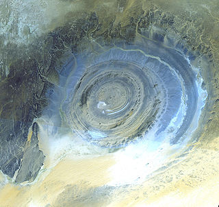
A dome is a feature in structural geology where a circular part of the earth's surface has been pushed upward, tilting the pre-existing layers of earth away from the center. In technical terms, it consists of symmetrical anticlines that intersect each other at their respective apices. Intact, domes are distinct, rounded, spherical-to-ellipsoidal-shaped protrusions on the Earth's surface. A slice parallel to Earth's surface of a dome features concentric rings of strata. If the top of a dome has been eroded flat, the resulting structure in plan view appears as a bullseye, with the youngest rock layers at the outside, and each ring growing progressively older moving inwards. These strata would have been horizontal at the time of deposition, then later deformed by the uplift associated with dome formation.

<span class="mw-page-title-main">Fractional crystallization (geology)</span> Process of rock formation

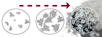
Fractional crystallization, or crystal fractionation, is one of the most important geochemical and physical processes operating within crust and mantle of a rocky planetary body, such as the Earth. It is important in the formation of igneous rocks because it is one of the main processes of magmatic differentiation. Fractional crystallization is also important in the formation of sedimentary evaporite rocks or simply fractional crystallization is the removal of early formed crystals from an Original homogeneous magma so that the crystals are prevented from further reaction with the residual melt.

<span class="mw-page-title-main">Igneous intrusion</span> Body of intrusive igneous rocks

In geology, an igneous intrusion is a body of intrusive igneous rock that forms by crystallization of magma slowly cooling below the surface of the Earth. Intrusions have a wide variety of forms and compositions, illustrated by examples like the Palisades Sill of New York and New Jersey; the Henry Mountains of Utah; the Bushveld Igneous Complex of South Africa; Shiprock in New Mexico; the Ardnamurchan intrusion in Scotland; and the Sierra Nevada Batholith of California.

In geology, a chonolith is a type of igneous rock intrusion. Igneous rock intrusions are bodies of igneous rock that are formed by the crystallization of cooled magma below the Earth’s surface. These formations are termed intrusive rocks due the magma intruding rock layers but never reaching the earth’s surface. However, sometimes portions of plutons can become exposed at the Earth’s surface and thus the minerals can be observed since they are large enough. The different plutonic formations are named based on the different shapes that the cooled crystallized magma takes. However, all plutonic formations that have irregular shapes and do not share the same characteristics as other plutonic structures are termed chonoliths. Other plutonic structures that have specific shapes include: dikes, sills, laccoliths and sheets. Another unique characteristic of chonoliths is that there is a floor or base present which is typically absent in other types of intrusions.

<span class="mw-page-title-main">Igneous rock</span> Rock formed through the cooling and solidification of magma or lava

Igneous rock, or magmatic rock, is one of the three main rock types, the others being sedimentary and metamorphic. Igneous rocks are formed through the cooling and solidification of magma or lava.

<span class="mw-page-title-main">Sheet intrusion</span> Geologic process and formation

A sheet intrusion, or tabular intrusion, is a planar sheet of roughly the same thickness, that forms inside a pre-existing rock. When it cuts into another unlayered mass, or across layers, it is called a dike. When it is formed between layers in a layered rock mass, it is called a sill.

The methods of pluton emplacement are the ways magma is accommodated in a host rock where the final result is a pluton. The methods of pluton emplacement are not yet fully understood, but there are many different proposed pluton emplacement mechanisms. Stoping, diapirism and ballooning are the widely accepted mechanisms. There is now evidence of incremental emplacement of plutons.

<span class="mw-page-title-main">Volcanic and igneous plumbing systems</span> Magma chambers

Volcanic and igneous plumbing systems (VIPS) consist of interconnected magma channels and chambers through which magma flows and is stored within Earth's crust. Volcanic plumbing systems can be found in all active tectonic settings, such as mid-oceanic ridges, subduction zones, and mantle plumes, when magmas generated in continental lithosphere, oceanic lithosphere, and in the sub-lithospheric mantle are transported. Magma is first generated by partial melting, followed by segregation and extraction from the source rock to separate the melt from the solid. As magma propagates upwards, a self-organised network of magma channels develops, transporting the melt from lower crust to upper regions. Channelled ascent mechanisms include the formation of dykes and ductile fractures that transport the melt in conduits. For bulk transportation, diapirs carry a large volume of melt and ascent through the crust. When magma stops ascending, or when magma supply stops, magma emplacement occurs. Different mechanisms of emplacement result in different structures, including plutons, sills, laccoliths and lopoliths.

References

  1. 1 2 Philpotts, Anthony R.; Ague, Jay J. (2009). Principles of igneous and metamorphic petrology (2nd ed.). Cambridge, UK: Cambridge University Press. pp. 93–94. ISBN   9780521880060.
  2. Leong, Goh Cheng (1995-10-27). Certificate Physics And Human Geography; Indian Edition. Oxford University Press. p. 20. ISBN   978-0-19-562816-6.
  3. Burchardt, Steffi; Mattsson, Tobias; Palma, J. Octavio; Galland, Olivier; Almqvist, Bjarne; Mair, Karen; Jerram, Dougal A.; Hammer, Øyvind; Sun, Yang (2019-08-14). "Progressive Growth of the Cerro Bayo Cryptodome, Chachahuén Volcano, Argentina—Implications for Viscous Magma Emplacement". Journal of Geophysical Research: Solid Earth. 124 (8): 7934–7961. Bibcode:2019JGRB..124.7934B. doi: 10.1029/2019JB017543 . ISSN   2169-9313.
  4. 1 2 3 Philpotts & Ague 2009, p. 95.
  5. 1 2 Philpotts & Ague 2009, p. 94.
  6. Philpotts & Ague 2009, equation 4.4, p.94.
  7. Philpotts & Ague 2009, pp. 79–80.
  8. Johnson, Arvid M.; Pollard, David D. (July 1973). "Mechanics of growth of some laccolithic intrusions in the Henry mountains, Utah, I". Tectonophysics. 18 (3–4): 261–309. doi:10.1016/0040-1951(73)90050-4.
  9. Pollard, David D.; Muller, Otto H.; Dockstader, David R. (1 March 1975). "The Form and Growth of Fingered Sheet Intrusions". GSA Bulletin. 86 (3): 351–363. Bibcode:1975GSAB...86..351P. doi:10.1130/0016-7606(1975)86<351:TFAGOF>2.0.CO;2.
  10. Castro, Jonathan M.; Cordonnier, Benoit; Schipper, C. Ian; Tuffen, Hugh; Baumann, Tobias S.; Feisel, Yves (December 2016). "Rapid laccolith intrusion driven by explosive volcanic eruption". Nature Communications. 7 (1): 13585. Bibcode:2016NatCo...713585C. doi:10.1038/ncomms13585. ISSN   2041-1723. PMC   5123016 . PMID   27876800.
  11. Mattsson, Tobias; Burchardt, Steffi; Almqvist, Bjarne S. G.; Ronchin, Erika (2018-02-05). "Syn-Emplacement Fracturing in the Sandfell Laccolith, Eastern Iceland—Implications for Rhyolite Intrusion Growth and Volcanic Hazards". Frontiers in Earth Science. 6: 5. Bibcode:2018FrEaS...6....5M. doi: 10.3389/feart.2018.00005 . hdl: 10023/20984 . ISSN   2296-6463.
  12. Morgan, Sven; Stanik, Amy; Horsman, Eric; Tikoff, Basil; de Saint Blanquat, Michel; Habert, Guillaume (April 2008). "Emplacement of multiple magma sheets and wall rock deformation: Trachyte Mesa intrusion, Henry Mountains, Utah". Journal of Structural Geology. 30 (4): 491–512. Bibcode:2008JSG....30..491M. doi:10.1016/j.jsg.2008.01.005.
  13. Fillmore, Robert (2010). Geological evolution of the Colorado Plateau of eastern Utah and western Colorado, including the San Juan River, Natural Bridges, Canyonlands, Arches, and the Book Cliffs. Salt Lake City: University of Utah Press. pp. 288–289. ISBN   9781607810049.
  14. 1 2 Fillmore 2010, pp. 292–293.
  15. Gilbert, G.K. (1877). "Geology of the Henry Mountains". Monograph. Washington, D.C. pp. i-160. doi: 10.3133/70038096 .{{cite book}}: CS1 maint: location missing publisher (link)
  16. Aber, James S. "Grove Karl Gilbert". academic.emporia.edu. Retrieved 29 December 2018.
  17. "laccolith". dictionary.com. Retrieved 29 December 2018.
  18. "Beall, Joseph J." "Pseudo-Rhythmic Layering in the Square Butte Alkali-Gabbro Laccolith." American Mineralogist. 57:7-8 (July–August 1972).
  19. Maynard, Steven R. (February 2005). "Laccoliths of the Ortiz porphyry belt, Santa Fe County, New Mexico" (PDF). New Mexico Geology. 27 (1). Retrieved 8 June 2020.
  20. Leuthold, Julien; Müntener, Othmar; Baumgartner, Lukas; Putlitz, Benita; Ovtcharova, Maria; Schaltegger, Urs (2012). "Time resolved construction of a bimodal laccolith (Torres del Paine, Patagonia)". Earth and Planetary Science Letters. 325–326: 85–92. Bibcode:2012E&PSL.325...85L. doi:10.1016/j.epsl.2012.01.032.
  21. Leuthold, Julien; Müntener, Othmar; Baumgartner, Lukas; Putlitz, Benita (2014). "Petrological constraints on the recycling of mafic crystal mushes and intrusion of braided sills in the Torres del Paine Mafic Complex (Patagonia)" (PDF). Journal of Petrology. 55 (5): 917–949. Bibcode:2014JPet...55..917L. doi:10.1093/petrology/egu011. hdl: 20.500.11850/103136 .
  22. 1 2 Spearing, Darwin. Roadside Geology of Texas. 1991. Mountain Press Publishing Company. ISBN   978-0-87842-265-4.
  23. Cook, E.F. (1957). "Geology of the Pine Valley Mountains Utah". Utah Geological and Mineralogical Studies (58): 1–111.
  24. Rocchi, Sergio; Westerman, David S.; Dini, Andrea; Innocenti, Fabrizio; Tonarini, Sonia (1 November 2002). "Two-stage growth of laccoliths at Elba Island, Italy". Geology. 30 (11): 983–986. Bibcode:2002Geo....30..983R. doi:10.1130/0091-7613(2002)030<0983:TSGOLA>2.0.CO;2.
  25. Vitaliano, Dorothy B. "Geomythology: geological origins of myths and legends" in Myth and Geology, ed. L. Piccardi and W. B. Masse, p. 1. Geological Society of London. ISBN   978-1-86239-216-8
  26. "Noe, D. C., and Alexander T. Klink. OF-15-06 Geologic Map of the Crawford Quadrangle, Delta and Montrose Counties, Colorado. 1:24,000". Colorado Geological Survey. Retrieved 26 July 2019.
  27. Jackson, Marie D.; Pollard, David D. (1 January 1988). "The laccolith-stock controversy: New results from the southern Henry Mountains, Utah". GSA Bulletin. 100 (1): 117–139. Bibcode:1988GSAB..100..117J. doi:10.1130/0016-7606(1988)100<0117:TLSCNR>2.3.CO;2.
  28. Wichman, R.W. and Schultz, P. H. (1996) Crater-Centered Laccoliths on the Moon: Modeling Intrusion Depth and Magmatic Pressure at the Crater Taruntius, Icarus, Volume 122, Issue 1, July 1996, pages 193-199. doi:10.1006/icar.1996.0118
  29. Wöhler, Christian; Lena, Raffaello (December 2009). "Lunar intrusive domes: Morphometric analysis and laccolith modelling". Icarus. 204 (2): 381–398. Bibcode:2009Icar..204..381W. doi:10.1016/j.icarus.2009.07.031.
  30. Michaut, Chloé (17 May 2011). "Dynamics of magmatic intrusions in the upper crust: Theory and applications to laccoliths on Earth and the Moon" (PDF). Journal of Geophysical Research. 116 (B5): B05205. Bibcode:2011JGRB..116.5205M. doi:10.1029/2010JB008108.
  31. Michaut, Chloé; Baratoux, David; Thorey, Clément (July 2013). "Magmatic intrusions and deglaciation at mid-latitude in the northern plains of Mars". Icarus. 225 (1): 602–613. Bibcode:2013Icar..225..602M. doi:10.1016/j.icarus.2013.04.015.
  32. Nabelek, Peter I. (2007). "Fluid evolution and kinetics of metamorphic reactions in calc-silicate contact aureoles—From H2O to CO2 and back". Geology. 35 (10): 927. Bibcode:2007Geo....35..927N. doi:10.1130/G24051A.1.
  33. Georgiev, N.; Henry, B.; Jordanova, N.; Jordanova, D.; Naydenov, K. (2014). "Emplacement and fabric-forming conditions of plutons from structural and magnetic fabric analysis: A case study of the Plana pluton (Central Bulgaria)". Tectonophysics. 629: 138–154. Bibcode:2014Tectp.629..138G. doi:10.1016/j.tecto.2014.02.018.

Further reading