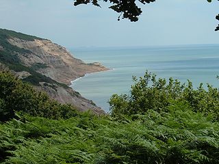
Lee Bay or just Lee is a small village on the North Devon coast near Woolacombe. Lee is situated on the rugged and inhospitable stretch of coast between Ilfracombe and Woolacombe, which includes Bull Point (with its lighthouse) and Morte Point, both notorious for shipwrecks in earlier times, and both on the South West Coast Path.
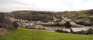
The village of Lee lies at the foot of what is known locally as the Fuchsia Valley, and consists of around 100 properties, mostly old in style. The village centre is about a 350 metres (380yd) from the sea, and is linked to the area around the bay by a road and level footpath. Lee is served by a combined pub, post office and shop, The Grampus; also by St Matthew's Church, by a gift/craft shop operating from the old schoolroom adjoining the church, and by the Lee Bay Hotel. As of 2009, the hotel was closed, and is being used by the police as a dog training centre.
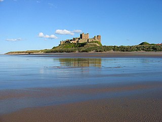
Around the bay area are the hotel (visible as the main building in the picture) and some 10 privately owned properties. Up to the late 1980s, several of these were in use as tea rooms, restaurants and gift shops.
The beach has a very gentle slope. As the tide goes out an expanse of sand emerges from among the rocks, as does a way through the cliffs westwards round to a large shingle beach called Sandy Cove or Bath Beach. This beach is also accessible from the coastal path via a National Trust-maintained path and staircase down the cliff face.
As the tide recedes further it becomes possible to scramble eastwards from Lee Bay over and round rocks and through pools to reach Broadoar, a mainly sandy beach, although it is possible to become trapped by incoming tides.
See also
Tarka Trail– which follows the line of the South West Coast Path through the village
Lee Bay lies within the North Devon Areas of Outstanding Natural Beauty.
Fairlight Glen lies about 2 miles (3.2 km) east of the fishing port of Hastings and 1.5 miles (2.4 km) west of the small village of Fairlight Cove on the East Sussex coast. It is a wooded area forming part of the Hastings Country Park Nature Reserve and leading down to Covehurst Bay. This is a naturist beach, but is shared by non-naturist visitors. The name Covehurst Bay is not normally used for the beach, but is marked on OS maps.
The Jurassic Coast is a World Heritage Site on the English Channel coast of southern England. It stretches from Exmouth in East Devon to Studland Bay in Dorset, a distance of about 96 miles (154 km), and was inscribed on the World Heritage List in mid-December 2001.
The South West Coast Path is England's longest waymarked long-distance footpath and a National Trail. It stretches for 630 miles (1,014 km), running from Minehead in Somerset, along the coasts of Devon and Cornwall, to Poole Harbour in Dorset. Because it rises and falls with every river mouth, it is also one of the more challenging trails. The total height climbed has been calculated to be 114,931 ft (35,031 m), almost four times the height of Mount Everest. It has been voted 'Britain's Best Walking route' twice in a row by readers of The Ramblers' Walk magazine, and regularly features in lists of the world's best walks.
North Cornwall is an area of Cornwall, England, United Kingdom. It is also the name of a former local government district, which was administered from Bodmin and Wadebridge 50.516°N 4.835°W. Other towns in the area are Launceston, Bude, Padstow, and Camelford.
Croyde is a village on the west-facing coastline of North Devon, England. The village lies on the South West Coast Path near to Baggy Point, which is owned by the National Trust. It lies within the North Devon Coast Area of Outstanding Natural Beauty. Croyde village and its beach faces the Atlantic Ocean near the western limit of the Bristol Channel.
Combe Martin is a village, civil parish and former manor on the North Devon coast about 4 miles (6.4 km) east of Ilfracombe. It is a small seaside resort with a sheltered cove on the northwest edge of the Exmoor National Park.
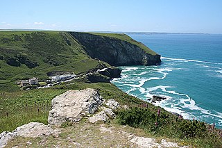
Godrevy is an area on the eastern side of St Ives Bay, west Cornwall, England, United Kingdom, which faces the Atlantic Ocean. It is popular with both the surfing community and walkers. It is part owned by the National Trust, and offshore on Godrevy Island is a lighthouse maintained by Trinity House which is said to be the inspiration for Virginia Woolf's novel To the Lighthouse. Godrevy lies within the Cornwall Area of Outstanding Natural Beauty (AONB) and the South West Coast Path runs around the whole promontory. There are several public car parks on the western side where the National Trust owns and operates a café.
Rhossili is both a small village and a community on the southwestern tip of the Gower Peninsula in Wales. It is within the first Area of Outstanding Natural Beauty in the United Kingdom. The village has a community council and is part of the Gower parliamentary constituency, and the Gower electoral ward. At the 2011 census, the population was 278. The community includes the hamlet of Pitton.
Woolacombe is a seaside resort on the coast of North Devon, England, which lies at the mouth of a valley in the parish of Mortehoe. The beach is 2 miles (3.2 km) long, sandy, gently sloping and faces the Atlantic Ocean near the western limit of the Bristol Channel.
Mortehoe is a village and former manor on the north coast of Devon, England. It lies 10 miles north-west of Barnstaple, near Woolacombe and Lee Bay, and is sited in a valley within the hilly sand-dune-like land behind Morte Point, almost directly above Woolacombe. The parish population at the 2011 census was 1,637.
Branscombe is a village in the East Devon district of the English County of Devon.
Putsborough is a hamlet in Georgeham Civil Parish on the west-facing coast of North Devon, England. It is about 3⁄4 mile (1.2 km) north of the village of Croyde and 1 mile (1.6 km) west-northwest of the village of Georgeham. 0.5 miles (0.8 km) north of the hamlet is Putsborough Sands, which forms the southern part of the two-mile-long (3 km) beach of Woolacombe Sand on Morte Bay.
Trebarwith Strand is a section of coastline located near the coastal settlement of Trebarwith on the north coast of Cornwall, England, UK, 2+1⁄2 miles (4.0 km) south of Tintagel. It has 800m of sandy beach contained by cliffs in which natural caves are found. The beach can only be accessed at low tide. The strand was once used to land ships to export slate from the nearby quarries while sand from the beach was used for agricultural purposes. The view from the beach is dominated by rocks 300m offshore known as Gull Rock or Otterham Rocks.
The North Devon Coast was designated as an Area of Outstanding Natural Beauty in September 1959. The AONB contributes to a family of protected landscapes in the Southwest of England and a total of 38% of the region is classified by the International Union for Conservation of Nature as Category V Protected Landscapes. The twelve Areas of Outstanding Natural Beauty extend to 30% of the region, twice the proportion covered by AONBs in England as a whole and a further two National Parks, Dartmoor and Exmoor, cover an additional 7%.
Gwbert, also known as Gwbert-on-Sea, is a cliff-top coastal village in Y Ferwig community, Ceredigion, Wales. It lies at the most southerly coastal point of Ceredigion, on the eastern shore of the Teifi estuary, from where there are views westwards over Cardigan Bay, and south-westwards to Poppit Sands and the headland of Cemaes Head, in neighbouring Pembrokeshire. It is reached by the B4548 road from the town of Cardigan, 2.8 miles (4.5 km) away.
The Northumberland Coast is a designated Area of Outstanding Natural Beauty (AONB) covering 40 miles (64 km) of coastline from Berwick-Upon-Tweed to the River Coquet estuary in the Northeast of England. Features include: Alnmouth, Bamburgh, Beadnell, Budle Bay, Cocklawburn Beach, Craster, Dunstanburgh Castle, the Farne Islands, Lindisfarne and Seahouses. It lies within the natural region of the North Northumberland Coastal Plain.
Baggy Point is a headland in north Devon, England. It separates Croyde Bay and Morte Bay which includes the beaches of Woolacombe and Putsborough.
Bideford Bay, also known as Barnstaple Bay and often shown on maps as Barnstaple or Bideford Bay, is a large area of water on the northwest coast of Devon in South West England, at the southwestern end of the Bristol Channel where it joins the Celtic Sea. The bay extends from Hartland Point in the southwest to Baggy point the northeast, and is partly sheltered by the island of Lundy, 12 miles (19 km) offshore. It takes its alternative names from the towns of Bideford and Barnstaple, located respectively on the rivers Torridge and Taw which flow into the bay. The alternative spelling Barnstable Bay, in use long after that spelling became obsolete for the town, is also sometimes seen.
Hobarrow Bay is a small secluded southwest-facing bay, with an oil shale and shingle beach to the southeast of Brandy Bay and to the southwest of Kimmeridge on the south coast of the Isle of Purbeck, in Dorset, England.
Morte Bay is a bay on the northwest coast of Devon in southwest England. It stretches from Whiting Hole about 500m north of Baggy Point in the south to Morte Point in the north. At the back of the bay is a long stretch of beach known as Woolacombe Sand though that southern section of the beach which is in the parish of Georgeham is known as Putsborough Sand. The village of Woolacombe is at the northeastern corner of the bay. To its south are the hills of Woolacombe Down and Pickwell Down which provide an eastern backdrop to the beach and the wider bay. The South West Coast Path and Tarka Trail follow the coast around the bay. The cliffs on the northern side of the bay are formed from the Morte Slates whilst those on the southern side are formed from the Upcott Slates. Underlying the bay itself and forming the higher ground to its east are the Pickwell Down Sandstones.
This page is based on this Wikipedia article Text is available under the CC BY-SA 4.0 license; additional terms may apply. Images, videos and audio are available under their respective licenses.