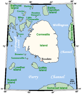
Cornwallis Island is one of the Queen Elizabeth Islands, part of the Canadian Arctic Archipelago, in the Qikiqtaaluk Region of Nunavut in the Canadian Arctic. It lies to the west of Devon Island and at its greatest length is about 113 km (70 mi). At 6,995 km2 (2,701 sq mi) in size, it is the 96th largest island in the world, and Canada's 21st largest island. Cornwallis Island is separated by the Wellington Channel from Devon Island, and by the Parry Channel from Somerset Island to the south. Northwest of Cornwallis Island lies Little Cornwallis Island, the biggest of a group of small islands at the north end of McDougall Sound, which separates Cornwallis Island from nearby Bathurst Island.

Thornbury is a small village and civil parish in the local government district of Torridge, Devon, England. The parish, which lies about five miles (8 km) north-east of the town of Holsworthy, comprises the five hamlets of Thornbury, Woodacott, Brendon, Lashbrook and South Wonford. These five hamlets are spread over an area of some 6 square miles (16 km2), with a distance of three miles (5 km) from Brendon to Thornbury Church. Hence, the community is quite widespread, with the only focal point being the Green at Woodacott Cross. The parish is surrounded clockwise from the north by the parishes of Milton Damerel, Bradford, Cookbury and Holsworthy Hamlets. In 2011, its population was 290, in 120 households, little changed from the 291 residents it had in 1901.
Brayford is a village and civil parish in Devon, England, situated about 5 miles (8.0 km) from South Molton and 6 miles (9.7 km) from Barnstaple. It lies on Exmoor and sits beneath open areas of common land. It is a small rural community and in the surrounding area are many farms.

Lanteglos-by-Fowey is a coastal civil parish in south Cornwall, England, United Kingdom. It is on the east side of the tidal estuary of the River Fowey which separates it from the town and civil parish of Fowey. The South West Coast Path runs along the southern coasts of the parish and much of the southern part of the parish lies in the Polruan to Polperro Site of Special Scientific Interest managed by the National Trust.

Pyworthy is a village and civil parish in the far west of Devon, England. It forms part of the local government district of Torridge. The parish lies to the west of the town of Holsworthy. It is surrounded clockwise from the north-west by the parishes of Bridgerule, a small part of Pancrasweek, Holsworthy Hamlets and Holsworthy, and Clawton. Its western border follows the River Tamar which forms the county boundary with Cornwall. In 2001 its population was 689, up from 429 in 1901.

Hexworthy is a hamlet on Dartmoor, in Devon, England. It lies on the West Dart River a mile upstream from Dartmeet. Historically in the parish of Lydford, since 1987 it has been in the civil parish of Dartmoor Forest.
Harford is a hamlet and civil parish located approximately 2 miles (3.2 km) north of the town of Ivybridge in the county of Devon, England. The parish lies in the local government district of the South Hams, which is a localised, second-tier governmental division of the non-metropolitan county of Devon, administered by Devon County Council.
Ware is a hamlet in the East Devon district of Devon, England. The hamlet lies approximately 0.8 miles (1.3 km) south-west from Lyme Regis, just off the Jurassic Coast.
Pinhay is a hamlet in the civil parish of Combpyne Rousdon in the East Devon district of Devon, England. The hamlet lies approximately 1.5 miles (2.4 km) south-west from Lyme Regis, its nearest town.
Church Green is a hamlet in the civil parish of Farway in the East Devon district of Devon, England. Its nearest town is Honiton, which lies approximately 2.9 miles (4.7 km) north from the hamlet.

Quoditch is a hamlet in the parish of Ashwater, part of the Torridge district of Devon, England. Its nearest town is Holsworthy, which lies approximately 5.6 miles (9.0 km) north-west from the hamlet.

Malmsmead is a hamlet on the border between the English counties of Devon and Somerset. The nearest town is Lynton, which lies approximately 4.7 miles (7.6 km) west of the hamlet. The hamlet is situated in the Doone Valley within the Exmoor National Park.
Furzehill is a hamlet in the North Devon district of Devon, England. Its nearest town is Lynton, which lies approximately 4 miles (6.4 km) north from the hamlet. The hamlet is situated in the Exmoor National Park, near the Devon-Somerset border.
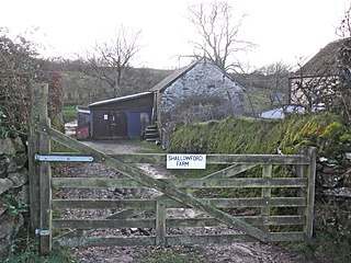
Shallowford is a hamlet in the civil parish of Furzehill in the North Devon district of Devon, England. Its nearest town is Lynton, which lies approximately 3.2 miles (5.1 km) north-east from the hamlet.
Roachill is a hamlet in the civil parish of Knowstone in the North Devon district of Devon, England. Its nearest town is Tiverton, which lies approximately 9.3 miles (15.0 km) south-west from the hamlet, just off the A361 road.
Creacombe is a small village and former civil parish, now in the parish of Rackenford in the North Devon district of Devon, England. Its nearest town is Tiverton, which lies approximately 9.4 miles (15.1 km) south-west from the hamlet, just off the A361 road. In 1961 the civil parish had a population of 52. On the 1 April 1986 the civil parish was merged with Rackenford.
Charles is a hamlet in the civil parish of East Buckland in the North Devon district of Devon, England. Its nearest town is South Molton, which lies approximately 4.7 miles (7.6 km) south-east from the hamlet, just off the A399 road.

Hollacombe is a village and small civil parish in the local government district of Torridge, Devon, England. It lies about five miles south east of the town of Holsworthy and is surrounded clockwise from the north by the parishes of Cookbury, Ashwater, and Holsworthy Hamlets. In 2001 its population was 59, compared to 69 in 1901.

Pancrasweek is a civil parish and hamlet in the far west of Devon, England forming part of the local government district of Torridge and lying about three miles north west of the town of Holsworthy.

West Buckfastleigh is a small civil parish on the eastern border of Dartmoor in Devon, England. Situated within the parish are the village of Scorriton and the hamlets of Michelcombe and Combe.


