North Devon

Last updated

North Devon District
North Devon UK locator map.svg
North Devon shown within Devon
Sovereign state United Kingdom
Constituent country England
Region South West England
Non-metropolitan county Devon
Status Non-metropolitan district
Admin HQ Barnstaple
Incorporated1 April 1974
Government
  TypeNon-metropolitan district council
  BodyNorth Devon Council
   MPs Selaine Saxby (C)
Area
  Total419.3 sq mi (1,085.9 km2)
  Rank23rd (of 296)
Population
 (2022)
  Total100,505
  Rank243rd (of 296)
  Density240/sq mi (93/km2)
  Ethnicity
97.9% White
Time zone UTC0 (GMT)
  Summer (DST) UTC+1 (BST)
ONS code 18UE (ONS)
E07000043 (GSS)
OS grid reference SS5586233371

North Devon is a local government district in Devon, England. Its council is based just outside Barnstaple, the district's largest town. The district also includes the towns of Ilfracombe, Lynton and Lynmouth and South Molton along with numerous villages and surrounding rural areas.

Contents

The east of the district includes part of the Exmoor National Park, and the district's coast is also recognised for its natural beauty, forming part of the North Devon Coast, an Area of Outstanding Natural Beauty.

The district borders Torridge to the south-west, Mid Devon to the south-east, and Somerset to the east.

The term "North Devon" can also be used to describe a wider geographic area than the local government district, often including neighbouring Torridge District, based in Bideford. [1]

History

The district was formed on 1 April 1974 under the Local Government Act 1972. The new district covered the area of five former districts, which were all abolished at the same time: [2]

The new district was named North Devon, reflecting its position within the wider county. [3] Since 2009 the council has styled itself "North Devon Council" rather than its full formal name of "North Devon District Council". [4] [5]

Governance

North Devon Council
North Devon Council logo.svg
Type
Type
History
Founded1 April 1974
Leadership
Helen Walker,
Liberal Democrats
since 27 March 2024 [6]
Ian Roome,
Liberal Democrats
since 18 May 2023 [7]
Ken Miles
since 2019
Structure
Seats42 councillors
UK North Devon District Council 2023.svg
Political groups
Administration (22)
  Liberal Democrat (22)
Other parties (20)
  Independents (10)
  Conservative (7)
  Green Party (3)
Elections
First past the post
Last election
4 May 2023
Next election
6 May 2027
Meeting place
Brynsworthy Environment Centre.jpg
Brynsworthy Environment Centre, Roundswell, Barnstaple, EX31 3NP
Website
www.northdevon.gov.uk

North Devon Council provides district-level services, including the administration of council tax and local benefits, the provision of car parking services, the collection of refuse and the recycling of waste, planning and building control, housing services, the provision of sport and leisure facilities, environmental services, business-related services and contingency planning. The council also runs and maintains the North Devon Crematorium. [8] County-level services are provided by Devon County Council. [9] The whole district is also covered by civil parishes, which form a third tier of local government. [10]

In the parts of the district within the Exmoor National Park, town planning is the responsibility of the Exmoor National Park Authority. The district council appoints two of its councillors to serve on the 22-person National Park Authority. [11]

Political control

The council has been under Liberal Democrat majority control since 2019.

The first election to the council was held in 1973, initially operating as a shadow authority before coming into its powers on 1 April 1974. Political control of the council since 1974 has been as follows: [12] [13]

Party in controlYears
Independent 1974–1987
No overall control 1987–1991
Liberal Democrats 1991–2007
Conservative 2007–2011
No overall control 2011–2019
Liberal Democrats 2019–present

Leadership

The leaders of the council since 1991 have been: [14]

CouncillorPartyFromTo
Malcolm Prowse [15] Liberal Democrats 19912007
Michael Harrison [16] Conservative 20072009
Des Brailey Conservative 20092011
Brian Greenslade [17] Liberal Democrats 20112015
Des Brailey Conservative 20155 May 2019
David Worden Liberal Democrats 16 May 201918 May 2023
Ian Roome Liberal Democrats 18 May 2023

Composition

Following the 2023 election, the composition of the council was: [18]

PartyCouncillors
Liberal Democrats 22
Independent 10
Conservative 7
Green 3
Total42

The independent councillors and Greens sit together as the "North Devon Independent Group". [19] The next elections are due in 2027.

Premises

Lynton House: Council's customer service centre in Barnstaple Lynton House.jpg
Lynton House: Council's customer service centre in Barnstaple
Barnstaple Civic Centre: Council's headquarters until 2015. The main entrance to Barnstaple civic centre - geograph.org.uk - 4578603.jpg
Barnstaple Civic Centre: Council's headquarters until 2015.

The council's main offices are at the Brynsworthy Environment Centre near Barnstaple (the building is in the parish of Fremington). The council moved there in 2015, having previously been based at the Civic Centre on North Walk in Barnstaple, which had been built in 1969 as joint offices for two of North Devon's predecessor councils, Barnstaple Town Council and Barnstaple Rural District Council. [20] [21] The council's main customer service centre is located at Lynton House, Commercial Road, Barnstaple, and it also maintains area offices in Ilfracombe and South Molton. [22]

Elections

Since the last boundary changes in 2019, the council has comprised 42 councillors representing 25 wards, with each ward returning between one and three councillors. Some wards are coterminous with civil parishes, though most consist of multiple parishes or parts of parishes. Elections are held every four years. [23] The following table lists the electoral wards of North Devon and the associated civil parishes.

WardCivil ParishesNo. of councillors
Barnstaple Central Barnstaple (part)1
Barnstaple With Pilton3
Barnstaple With Westacott3
Bickington Fremington (part)3
Bishop's Nympton1
Bratton Fleming1
Braunton East Braunton (part)2
Braunton West & Georgeham2
Chittlehampton1
Chulmleigh1
Combe Martin Combe Martin 1
FremingtonFremington (part)2
Heanton Punchardon1
Ilfracombe East Ilfracombe (part)3
Ilfracombe WestIlfracombe (part)2
Instow1
Landkey2
Lynton & Lynmouth1
Marwood1
Mortehoe1
NewportBarnstaple (part)2
North Molton1
Roundswell
  • Barnstaple (part)
  • Tawstock (part)
2
South Molton South Molton 3
Witheridge1

Towns and parishes

Parishes of North Devon NorthDevonParishesMap.PNG
Parishes of North Devon

The whole district is covered by civil parishes. The parish councils for Barnstaple, Ilfracombe, Lynton and Lynmouth, and South Molton are styled "town councils". Some of the smaller parishes have a parish meeting rather than a parish council. [24] [25]

Demography

North Devon is popular with retired people. The 2011 census showed that 18% of residents were aged 15 years and under, 60% were aged 16–64 and 23% were aged 65 and over. This compares to the 20% of the population who were aged 65 and over when the 2001 census was taken. For comparison, the same age distributions across England were 19%, 64% and 17% respectively. [26] Life expectancy for men, at 77.7, is close to the English average. Female life expectancy is good at 83.1, around 1 year above the English average. [27]

There is a gap of six years in the life expectancy of men in the least deprived fifth of wards and the most deprived fifth. [27] The region has one of the most ethnically homogenous populations in England, with 97.9% reporting their ethnicity as 'white' in the 2011 census of the population. [28] However, this is a decrease on the 99.0% of the population who declared themselves to be white on the 2001 census.

Transport

Along with its neighbours to the east, West Somerset, and west, Torridge, North Devon has fairly sparse transport links. The Beeching cuts in the mid-sixties left the branch line to Exeter as the area's only railway service. Despite being served by only one railway line, the district is served by 5 railway stations, which is a large number, comparable with more urbanised boroughs such as Plymouth and Mid Devon. However sizeable settlements of Braunton and Ilfracombe as well as Bideford are cut off from the Network Rail system.

The district is served by three A roads. The primary link is the A361 (known locally as the Link Road) which was constructed between 1986 and 1989. It heads north-west from the M5 motorway, past South Molton, to Barnstaple. From here the A361 classification continues northwards along older roads to Ilfracombe, and the modern Link Road continues westwards from Barnstaple as the A39 where it is designated the Atlantic Highway, and runs via Bideford into Cornwall. The eastern section of the A39 links Barnstaple to Lynton, then crosses the northern coastal hills of Exmoor into Somerset.

The other two A roads in North Devon are the A399, a minor local route between Ilfracombe and South Molton (used as a de facto Barnstaple-bypass to Ilfracombe and Woolacombe), and the A377, which is the main road between Barnstaple and the county town of Devon, Exeter.

Due to significant peak time traffic delays in Barnstaple, and severe congestion at both peak and non-peak times in the summer when tourist traffic is at its busiest, the Barnstaple Western Bypass was opened in 2007.

Economy

North Devon is some distance from the UK's traditional areas of industrial activity and population yet boasts some major manufacturing sites that export around the world, among them TDK Lambda and Pall Europe in Ilfracombe, Eaton Aerospace and Norbord in South Molton, Perrigo in Braunton and multiple businesses in Barnstaple. Due to the historically agricultural nature of the economy alongside a strong tourism industry employment can be seasonal. As a result, some areas of North Devon are considered deprived. The overall average income for the district is 80% of the average for the United Kingdom as a whole.

The 1989 opening of the new Link Road connection to the motorway network helped to promote trade, but it had a temporary detrimental effect on a number of distribution businesses. The latter had previously viewed the town as a base for local distribution networks, a need that was removed with an approximate halving of travelling time to the M5 motorway. The region adapted: in 2005 unemployment in North Devon was 1.8–2.4% but in 2018 unemployment in North Devon had come down significantly since its 2010 high to 1.1%. Median weekly full-time pay is £440 per week, the average house price is £230,000 and the number of businesses registered has increased to 4895, up 370 from 2010. 2018 has seen significant Government investment in the area through Coastal Community grants and Housing Infrastructure funds, as well as £83 million to further upgrade the North Devon Link Road. [29]

Barnstaple is the main shopping area for North Devon. There are many chain stores in the town centre and in the Roundswell Business Park, on the western fringe of the town. Tesco has several stores in the area, including a Tesco Extra hypermarket, a large Tesco superstore. There is also a Sainsbury's superstore, a Lidl supermarket. The multimillion-pound redevelopment of the former Leaderflush Shapland works at Anchorwood Bank, and the surrounding area, is creating a conservation area near the River Taw, hundreds of new homes, a commercial retail area with new shops, restaurants and leisure facilities. A new Asda superstore and petrol filling station is part of the redevelopment. The new Asda store opened in November 2016.[ citation needed ]

The largest employer in the region is local and central Government. The two main government employers in the area are the Royal Marines Base Chivenor, 3 miles (4.8 km) west of the town, and North Devon District Hospital, 1 mile (1.6 km) to the north.

Ilfracombe, seen from 447 feet (136 metres) above. The viewpoint (Hillsborough) is part of the South West Coastal Path Ilfracombe.view1.arp.750pix.jpg
Ilfracombe, seen from 447 feet (136 metres) above. The viewpoint (Hillsborough) is part of the South West Coastal Path

Barnstaple

Barnstaple is on the River Taw estuary, and functions as the main service centre for North Devon. The parish of Barnstaple had a population of 97,214 at the 2011 census. [30] The wider Barnstaple Built-Up Area was estimated to have a population of 32,411 in 2018, [31]  whilst the Barnstaple Town Area, which contains satellite settlements such as Bishop's Tawton, Fremington and Landkey, has a population of 46,619 (as of 2020). [32]

See also

Related Research Articles

<span class="mw-page-title-main">Bideford</span> Town in Devon, England

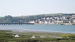
Bideford is a historic port town on the estuary of the River Torridge in north Devon, south-west England. It is the main town of the Torridge local government district.

<span class="mw-page-title-main">Barnstaple</span> Town in Devon, England

Barnstaple is a river-port town and civil parish in the North Devon district of Devon, England. The town lies at the River Taw's lowest crossing point before the Bristol Channel. From the 14th century, it was licensed to export wool from which it earned great wealth. Later it imported Irish wool, but its harbour silted up and other trades developed such as shipbuilding, foundries and sawmills. A Victorian market building survives, with a high glass and timber roof on iron columns.

<span class="mw-page-title-main">Ilfracombe</span> Town in Devon, England

Ilfracombe is a seaside resort and civil parish on the North Devon coast, England, with a small harbour surrounded by cliffs.

<span class="mw-page-title-main">Torridge District</span> Local Government district in Devon, England

Torridge is a local government district in north-west Devon, England. Its council is based in the town of Bideford. The district also includes the towns of Great Torrington, Holsworthy and Northam, along with numerous villages and surrounding rural areas. The island of Lundy forms part of the district. The district is named after the River Torridge.

<span class="mw-page-title-main">A39 road</span> Road in south west England

The A39 is an A road in south west England. It runs south-west from Bath in Somerset through Wells, Glastonbury, Street and Bridgwater. It then follows the north coast of Somerset, Devon and Cornwall through Williton, Minehead, Porlock, Lynmouth, Barnstaple, Bideford, Stratton, Camelford, Wadebridge and St Columb Major. It then joins the route of the A30 road for around 5 miles (8.0 km), re-emerging near Zelah to head for the south Cornish coast via Truro and Falmouth.

<span class="mw-page-title-main">Northam, Devon</span> Town in Devon, England

Northam is a market town, civil parish and electoral ward in Devon, England, lying north of Bideford. The civil parish also includes the villages of Westward Ho!, Appledore, West Appledore, Diddywell, Buckleigh and Silford, and the residential areas of Orchard Hill and Raleigh Estate.

<span class="mw-page-title-main">North Devon (UK Parliament constituency)</span> UK Parliament constituency

North Devon is a constituency represented in the House of Commons of the UK Parliament since 2019 by Selaine Saxby of the Conservative Party.

<span class="mw-page-title-main">Tarka Trail</span> Series of foot and cyclepaths in England

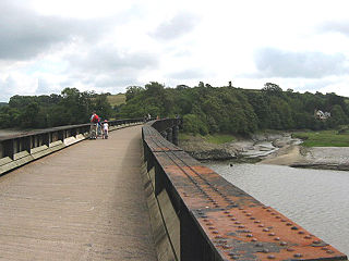
The Tarka Trail is a series of footpaths and cyclepaths around north Devon, England that follow the route taken by the fictional Tarka the Otter in the book of that name. It covers a total of 180 miles (290 km) in a figure-of-eight route, centred on Barnstaple.

South Molton is a town and civil parish in Devon, England. It is part of the North Devon local government district. The town is on the River Mole.

<span class="mw-page-title-main">Bratton Fleming</span> Village in Devon, England

Bratton Fleming is a large village, civil parish and former manor in Devon, England, about 6 miles (10 km) north-east of Barnstaple and near the western edge of Exmoor. The parish includes the hamlets of Knightacott and Stowford. The population of the parish in 2001 was 942, falling to 928 in 2011. There is an electoral ward with the same name which at the 2011 census had a population of 2,117.

<span class="mw-page-title-main">High Bickington</span> Village in Devon, England

High Bickington is a rural village and civil parish in the Torridge district of Devon, England. The village lies on the B3217 road, around 6 miles (10 km) east of Great Torrington, 8 miles (13 km) south-west of South Molton, and 8 miles (13 km) south of Barnstaple. At the 2011 Census, the parish had a population of 837.

The EX postcode area, also known as the Exeter postcode area, is a group of 33 postcode districts in South West England, within 30 post towns. These cover north and east Devon, plus the northernmost part of Cornwall and very small parts of Somerset and Dorset.

<span class="mw-page-title-main">Bideford Bay</span>

Bideford Bay, also known as Barnstaple Bay and often shown on maps as Barnstaple or Bideford Bay, is a large area of water on the northwest coast of Devon in South West England, at the southwestern end of the Bristol Channel where it joins the Celtic Sea. The bay extends from Hartland Point in the southwest to Baggy point the northeast, and is partly sheltered by the island of Lundy, 12 miles (19 km) offshore. It takes its alternative names from the towns of Bideford and Barnstaple, located respectively on the rivers Torridge and Taw which flow into the bay. The alternative spelling Barnstable Bay, in use long after that spelling became obsolete for the town, is also sometimes seen.

<span class="mw-page-title-main">Lynton and Lynmouth</span> Area of Devon

Lynton and Lynmouth is a civil parish in the North Devon district of Devon, England. The parish is named after its two main settlements of Lynton, which stands on a plateau above the Glen Lyn Gorge, and Lynmouth which lies at the foot of the gorge where the West Lyn River and East Lyn River converge and then meet the sea. The two are connected by the Lynton and Lynmouth Cliff Railway, a water-powered funicular railway.

<span class="mw-page-title-main">Martinhoe</span> Village in Devon, England

Martinhoe is a small settlement and civil parish in North Devon district of Devon, England. Martinhoe is within the Exmoor National Park, the smallest National Park in England. In the 2011 census Martinhoe Parish was recorded as having a population of 159. Martinhoe is in the Combe Martin ward, for elections to the district council. Martinhoe's local government takes the form of a parish meeting and as such has no parish council nor elected parish councillors.

Barnstaple Rural District was a rural district in the administrative county of Devon, England, from 1894 to 1974, covering a coastal area in the north of the county. Whilst the district was named after the town of Barnstaple and had its offices there, the district did not include the town itself.

South Molton Rural District was a rural district in the administrative county of Devon, England, from 1894 to 1974, covering an area in the north of the county. The district was named after the town of South Molton and had its offices there. The town itself was initially excluded from the rural district, being a self-governing municipal borough. In 1967 the town was absorbed into the district.

References

  1. "Visit North Devon and Exmoor" . Retrieved 23 June 2023.
  2. "The English Non-metropolitan Districts (Definition) Order 1972", legislation.gov.uk , The National Archives, SI 1972/2039, retrieved 31 May 2023
  3. "The English Non-metropolitan Districts (Names) Order 1973", legislation.gov.uk , The National Archives, SI 1973/551, retrieved 31 May 2023
  4. "North Devon District Council". Archived from the original on 2 May 2009. Retrieved 23 June 2023.
  5. "North Devon Council". Archived from the original on 2 June 2009. Retrieved 23 June 2023.
  6. "Council minutes, 27 March 2024". North Devon Council. Retrieved 10 May 2024.
  7. Clarke, Lewis (23 May 2023). "North Devon Council appoints MP-hopeful councillor Ian Roome as leader". Devon Live. Retrieved 23 June 2023.
  8. "North Devon Council". North Devon Council. Retrieved 14 August 2016.
  9. "Local Government Act 1972", legislation.gov.uk , The National Archives, 1972 c. 70, retrieved 31 May 2023
  10. "Election maps". Ordnance Survey. Retrieved 6 June 2023.
  11. "Members". Exmoor National Park. Retrieved 1 August 2023.
  12. "Compositions calculator". The Elections Centre. 4 March 2016. Retrieved 1 June 2023.
  13. "England council elections". BBC News Online . Retrieved 30 July 2011.
  14. "Council minutes". North Devon Council. Retrieved 30 July 2022.
  15. "Tories get control of North Devon". BBC News. 4 May 2007. Retrieved 30 July 2022.
  16. Harris, Lauren (24 October 2017). "Tributes to 'generous' former leader of North Devon council". Devon Live. Retrieved 23 June 2023.
  17. Richards, Alex (5 July 2018). "Who is Brian Greenslade? The former council leader who sexually harassed and abused women". Devon Live. Retrieved 30 July 2022.
  18. "Local elections 2023: live council results for England". The Guardian.
  19. Clarke, Lewis (6 June 2023). "North Devon's Greens and Independents unite to challenge Lib Dems". Devon Live. Retrieved 23 June 2023.
  20. Cooper, Joel (6 January 2020). "Council is 'finalising sale' of one of Devon's ugliest buildings". Devon Live. Retrieved 30 July 2022.
  21. "Visit us for a public meeting". North Devon Council. Retrieved 30 July 2022.
  22. "Contact our Customer Services Team". North Devon Council. Retrieved 23 June 2023.
  23. "The North Devon (Electoral Changes) Order 2018", legislation.gov.uk , The National Archives, SI 2018/1178, retrieved 23 June 2023
  24. "Election Maps". Ordnance Survey. Retrieved 1 June 2023.
  25. "Parish council contact details". North Devon Council. Retrieved 23 June 2023.
  26. "Archived copy" (PDF). Archived from the original (PDF) on 23 September 2015. Retrieved 26 June 2013.{{cite web}}: CS1 maint: archived copy as title (link)
  27. 1 2 "Archived copy". Archived from the original on 5 September 2015. Retrieved 9 February 2014.{{cite web}}: CS1 maint: archived copy as title (link)
  28. "2011 Census - Ethnicity". Government of the United Kingdom.
  29. "Barnstaple (Parish, United Kingdom) - Population Statistics, Charts, Map and Location". citypopulation.de. Retrieved 28 March 2020.
  30. "Barnstaple (Devon, South West England, United Kingdom) - Population Statistics, Charts, Map, Location, Weather and Web Information". citypopulation.de. Retrieved 28 March 2020.
  31. "Barnstaple profile". Communities. 8 December 2014. Retrieved 28 March 2020.

51°04′52″N4°03′29″W / 51.081°N 4.058°W / 51.081; -4.058