South Hams

Last updated

South Hams
Hallsands & Beesands 2.jpg
From Start Point looking towards Hallsands and Beesands
South Hams UK locator map.svg
South Hams shown within Devon
Coordinates(Totnes): 50°25′53″N3°41′28″W / 50.43139°N 3.69111°W / 50.43139; -3.69111
Sovereign state United Kingdom
Constituent country England
Region South West England
Non-metropolitan county Devon
Formed 1 April 1974
Government
  TypeDistrict council
  BodySouth Hams District Council
  HQ Totnes
  Sub-divisions Civil parishes
   UK Parliament South West Devon
Totnes
   MPs Gary Streeter (C)
Anthony Mangnall (C)
Area
  Total342.28 sq mi (886.51 km2)
  Rank Ranked 36th
Population
 (2021)
  Total89,213
  Rank Ranked 266th
  Density260/sq mi (101/km2)
  Ethnicity
ONS code 18UG

South Hams is a local government district on the south coast of Devon, England. Its council is based in the town of Totnes, although the largest town is Ivybridge. The district also contains the towns of Dartmouth, Kingsbridge and Salcombe and numerous villages and surrounding rural areas.

Contents

Much of the district's landscape is recognised for its natural beauty; the north of the district includes part of Dartmoor National Park, the district's coastline and adjoining areas form most of the South Devon Area of Outstanding Natural Beauty, and part of the west of the district lies within the Tamar Valley AONB. The district's coast includes the promontories of Start Point and Bolt Head.

The neighbouring districts are Torbay, Teignbridge, West Devon, Cornwall (across the Tamar–Tavy Estuary) and Plymouth.

Toponymy

"Ham" is an Old English term which can mean a homestead, river meadow or peninsula. [1] The settled farming areas either side of the largely uninhabited wilderness of Dartmoor were anciently termed the "North Hams" and "South Hams" respectively. The name North Hams fell out of general usage, but the name South Hams continued to be used for the area between Dartmoor and the south coast. [2]

History

The South Hams were formerly part of the Brythonic (Celtic) Kingdom of Dumnonia. Post-Roman settlement on coastal promontory hillforts, such as Burgh Island, followed the established pattern of trading (particularly of tin) found across the western Atlantic coastal regions. The Anglo-Saxon conquest of south Devon was completed in the late 7th and early 8th centuries. [3] In the later Anglo-Saxon era, the South Hams was a feudal estate consisting of all of the land between the River Plym and River Dart and south of Dartmoor with the English Channel forming the southern boundary. As a result of claims made by 19th antiquarian Richard Polwhele, there is a popular belief that Cornish continued to be spoken in the area until the later middle ages and as late as the 14th century. However, there is, in fact, no evidence supporting this. [4]

In 1917, the village of Hallsands was abandoned after much of it was lost to the sea following the removal of the shingle bank protecting the shore to help build Devonport dockyard. [5]

In 1944 several villages were evacuated so that training for D-Day could be carried out in secret. The area was chosen because of the resemblance of its beaches to those of Normandy. Preparations were disrupted, and secrecy nearly compromised, by a devastating E-boat attack during Exercise Tiger.

The modern local government district was formed on 1 April 1974 under the Local Government Act 1972, covering the area of seven former districts which were all abolished at the same time: [6]

The new district was named South Hams, using the long-established name for the area. [7]

Governance

South Hams District Council
South Hams District Council logo.png
Type
Type
History
Founded1 April 1974
Leadership
Guy Pannell,
Liberal Democrat
since 25 May 2023
Julian Brazil,
Liberal Democrat
since 25 May 2023 [8]
Andy Bates
since June 2020 [9]
Structure
Seats31 councillors
Political groups
Administration (19)
  Liberal Democrats (19)
Opposition (12)
  Conservative (7)
  Green (3)
  Labour (1)
  Independent (1)
Elections
First past the post
Last election
4 May 2023
Next election
6 May 2027
Meeting place
Follaton House - Totnes - geograph.org.uk - 38661.jpg
Follaton House, Plymouth Road, Totnes, TQ9 5NE
Website
www.southhams.gov.uk

South Hams District Council provides district-level services. County-level services are provided by Devon County Council. [10] The whole district is also covered by civil parishes, which form a third tier of local government. [11]

In the parts of the district within the Dartmoor National Park, town planning is the responsibility of the Dartmoor National Park Authority. The district council appoints one of its councillors to serve on the 19-person National Park Authority. [12]

Political control

The council has been under Liberal Democrat majority control since the 2023 election.

The first election to the council was held in 1973, initially operating as a shadow authority alongside the outgoing authorities until the new arrangements came into effect on 1 April 1974. Political control of the council since 1974 has been as follows: [13] [14]

Party in controlYears
Independent 1974–1983
No overall control 1983–1987
Conservative 1987–1995
No overall control 1995–1999
Conservative 1999–2023
Liberal Democrats 2023–present

Leadership

The leaders of the council since 1994 have been: [15] [16]

CouncillorPartyFromTo
Owen Masters Conservative 19941995
Doreen Flood Liberal Democrats 19951999
Owen Masters Conservative 19992001
Richard Yonge Conservative 20016 May 2007
John Tucker Conservative May 20075 May 2019
Judy Pearce Conservative 16 May 20197 May 2023
Julian Brazil Liberal Democrats 25 May 2023

Composition

Following the 2023 election, the composition of the council was: [17]

PartyCouncillors
Liberal Democrats 19
Conservative 7
Green 3
Labour 1
Independent 1
Total31

The next election is due in 2027.

Premises

The council is based at Follaton House, a large converted house on the outskirts of Totnes. [18] The main house dates back to the early nineteenth century and is a Grade II* listed building. [19] The building had been bought by the old Totnes Rural District Council for £26,000 in 1965 and converted to become its offices, transferring to the new South Hams District Council on local government reorganisation in 1974. [20] [21]

Geography

The district's geography can be described in terms of three loosely-defined bands: a coastal band of bays, headlands, birdlife, fishing and small harbour towns with the estuaries and rias; a middle band with the main, well-conserved towns; and a sparsely populated band of upland National Park moorland in the north. For over a century its tourism was concentrated around the railway, with most stations built here from 1847 to 1872 so tourism to its beaches and fishing villages began in earnest later than to the 'English Riviera' east of the area. South Hams' widespread tourism multiplied on the dualling of the A38 and time-cutting construction of the M5 and A303 across other parts of south-west England.

In the north, there is...the "wildscape"—...[a new] bypass [to the A30, the A38]...cut[s] through some of the most beautiful country in Britain, that of the Dartmoor national park....while in the south-west there is extensive mining of china clay...[an abortive] tungsten mine in the Shaugh PriorSparkwell area will be [would have been] amongst the largest in the world and probably the largest in Europe. The wildscape band runs from Cadover Bridge and Shaugh Prior in the west right over to the other side of Dartmoor, to the Avon dam, Shipley Bridge and South Brent, touching the outskirts of Buckfastleigh.

The second band is the agricultural belt of lush, fertile farmland which produces some of the finest milk and Devon cream. Within that belt are the medieval towns of Modbury and Totnes and small hamlets and villages such as...Holbeton, Marldon and Berry Pomeroy.

The third band is the Heritage coast [and South Devon Area of Outstanding Natural Beauty], running from near the fishing port of Brixham through Churston, [lower-alpha 2] Kingswear, Dartmouth, Slapton Sands, Torcross, East Prawle, Salcombe and Bigbury Bay almost to the boundaries of Plymouth in Heybrook bay. That area is filled with rivers such as the Erme, the Plym, the Avon and the Dart. [There is] an island in the shape of Burgh Island. There are rolling hills, deep wooded valleys, estuaries full of fish and a coastline full of crab, lobsters and oysters. The climate is warm and mellow. Some regard it as a garden of Eden. We even have a naturist beach and hotel. ...forgive me if I wax lyrical about this beautiful, delightful area. Tourism is an important livelihood...the other is farming...for many. [22]

Anthony Steen, MP for this area (1983–2010), South-West Region potential and current public priorities debate, 1983)

The South Hams, along with nearby Broadsands in Paignton, is the last British refuge of the cirl bunting.[ citation needed ]

Parishes and settlements

The whole district is covered by civil parishes. Some of the smaller parishes have a parish meeting rather than a parish council. The parish councils for Dartmouth, Ivybridge, Kingsbridge, Salcombe and Totnes take the style "town council". [23]

Settlements in the district include:

Elections

Since the last boundary changes in 2015 the council has comprised 31 councillors representing 20 wards, with each ward election one, two or three councillors. Elections are held every four years. [24]

The South Hams district straddles the two parliamentary constituencies of South West Devon and Totnes.

In the 2016 EU Referendum it voted to remain with a very high (80.3%) turnout. [25] [26]

Wards

Some of the district's wards are coterminous with civil parishes, though most consist of multiple parishes or parts of parishes. The following table lists the electoral wards of South Hams and the associated civil parishes.

WardCivil ParishesNo. of councillors
Allington & Strete1
Bickleigh & Cornwood1
Blackawton & Stoke Fleming1
Charterlands1
Dartington & Staverton1
Dartmouth & East Dart3
Ermington & Ugborough1
Ivybridge East2
Ivybridge WestIvybridge (part)2
Kingsbridge Kingsbridge 2
Loddiswell & Aveton Gifford1
Marldon & Littlehempston1
Newton & Yealmpton2
Salcombe & Thurlestone2
South Brent2
Stokenham1
Totnes Totnes 3
Wembury & Brixton2
West Dart1
WoolwellBickleigh (part)1

See also

Notes

    1. Formally called "Clifton Dartmouth Hardness".
    2. Brixham and Churston were in the South Hams constituency are geographically within neighbouring Torbay but were part of the South Hams Parliamentary constituency.

    Related Research Articles

    <span class="mw-page-title-main">Dartmouth, Devon</span> Town in England

    Dartmouth is a town and civil parish in the English county of Devon. It is a tourist destination set on the western bank of the estuary of the River Dart, which is a long narrow tidal ria that runs inland as far as Totnes. It lies within the South Devon Area of Outstanding Natural Beauty and South Hams district, and had a population of 5,512 in 2001, reducing to 5,064 at the 2011 census. There are two electoral wards in the Dartmouth area. Their combined population at the above census was 6,822.

    <span class="mw-page-title-main">Kingsbridge</span> Market town in the South Hams district of Devon, England

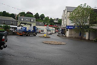
    Kingsbridge is a market town in the South Hams district of Devon, England, with a population of 6,116 at the 2011 census. Two electoral wards bear the name of Kingsbridge. Their combined population at the above census was 4,381. It is situated at the northern end of the Kingsbridge Estuary, a ria that extends to the sea six miles (10 km) south of the town. It is the third largest settlement in the South Hams and is 17 miles (27 km) southwest of Torquay and 17 miles (27 km) southeast of Plymouth.

    <span class="mw-page-title-main">Ivybridge</span> Town in Devon, England

    Ivybridge is a town and civil parish in the South Hams, in Devon, England. It lies about thirteen miles east of Plymouth. It is at the southern extremity of Dartmoor, a National Park of England and Wales and lies along the A38 "Devon Expressway" road. There are two electoral wards in Ivybridge East and Ivybridge West with a total population of 11,851.

    <span class="mw-page-title-main">West Devon</span> Non-metropolitan district and borough in England

    West Devon is a local government district with borough status in Devon, England. Its council is based in Tavistock, the borough's largest town. The borough also includes the towns of Hatherleigh, North Tawton and Okehampton, along with numerous villages and surrounding rural areas.

    <span class="mw-page-title-main">River Erme</span> River in south Devon, England

    The Erme is a river in south Devon, England. From its source on Dartmoor it flows in a generally southerly direction past some of the best-preserved archaeological remains on the moor. It leaves the moor at the town of Ivybridge and continues southward, passing the settlements of Ermington, Modbury and Holbeton. Near Holbeton it becomes a ria and empties into the English Channel in Bigbury Bay, between the rivers Yealm and Avon.

    <span class="mw-page-title-main">South Pool</span> Village in Devon, England

    South Pool is a village, parish and former manor in South Hams, Devon, England. It is situated 3 1/2 miles south-east of the town of Kingsbridge and 2 1/2 miles north-east of Salcombe. It is administered by the South Hams local authority. Historically it formed part of Coleridge Hundred. It falls within Woodleigh Deanery for ecclesiastical purposes. The village is in an area of outstanding natural beauty at the head of South Pool creek.

    <span class="mw-page-title-main">Totnes (UK Parliament constituency)</span> Parliamentary constituency in the United Kingdom, 1997 onwards

    Totnes is a parliamentary constituency in Devon represented in the House of Commons of the UK Parliament since December 2019 by Anthony Mangnall, a Conservative. Mangnall defeated incumbent Sarah Wollaston who had originally been elected as a Conservative but defected to the Liberal Democrats earlier that year.

    <span class="mw-page-title-main">South West Devon (UK Parliament constituency)</span> UK Parliament constituency

    South West Devon is a constituency represented in the House of Commons of the UK Parliament since 1997 by Sir Gary Streeter, a Conservative.

    <span class="mw-page-title-main">Abbotsleigh, Devon</span> Hamlet in Devon, England

    Abbotsleigh is a hamlet in the county of Devon, England. Abbotsleigh is in the civil parish of Blackawton, within the district council of South Hams in Devon. It is about 5 miles (8.0 km) south-west of Dartmouth.

    <span class="mw-page-title-main">South Hams (UK Parliament constituency)</span>

    South Hams was a county constituency based on the South Hams district of Devon. It returned one Member of Parliament (MP) to the House of Commons of the Parliament of the United Kingdom. The constituency was created for the 1983 general election, and abolished for the 1997 general election. The constituency covered a vast part of the English Riviera on the south Devon coast.

    <span class="mw-page-title-main">A381 road</span> Road in Devon, England

    The A381 road is a non-trunk 'A'-class road in Devon, England which serves as an important link between the towns of Teignmouth, Kingsteignton, Newton Abbot, Totnes and Salcombe and many villages in between, with the busiest section having 6 lanes and carrying an average of over 40,000 vehicles per day. The route overlaps with other A-roads for several sections of its length. It is a faster route from Teignmouth to Salcombe than the A379 which meets it at both ends. It is under the control of Devon County Council as highway authority.

    <span class="mw-page-title-main">Stokenham</span> Village in Devon, England

    Stokenham is a village and civil parish in the South Hams district, in the county of Devon, England. The population of the parish at the 2011 census was 1,895.

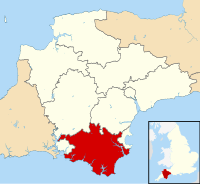
    South Devon is the southern part of Devon, England. Because Devon has its major population centres on its two coasts, the county is divided informally into North Devon and South Devon. In a narrower sense "South Devon" is used to refer to the part of Devon south of Exeter and Dartmoor, including Plymouth, Torbay and the districts of South Hams, West Devon and Teignbridge.

    <span class="mw-page-title-main">2019 South Hams District Council election</span>

    Elections to South Hams District Council took place on 2 May 2019, the same day as other United Kingdom local elections. All 20 wards were up for election, each with either 1, 2 or 3 councillors to be elected. The Conservative Party retained overall control of the council, but with their majority reduced to just 1 seat.

    <span class="mw-page-title-main">2023 South Hams District Council election</span>

    The 2023 South Hams District Council election took place on 4 May 2023 to elect all 31 members of South Hams District Council in Devon, England. This was on the same day as other local elections across England. All 20 wards were up for election, each with either one, two or three councillors to be elected.

    References

    1. "The South Hams and Devon's far south". Bradt Guides. Retrieved 31 July 2023.
    2. Harpley, William, ed. (1878). "Notes on the historical connections of Devonshire place-names". Report and transactions of the Devonshire Association for the advancement of science, literature and art, Volume 10. Plymtouh: W. Bredon and Son. p. 306. Retrieved 31 July 2023.
    3. Loyn, H.R. (1991). Anglo Saxon England and the Norman Conquest. Longman. pp. 49–50. ISBN   9780582072961.
    4. Payton, Philip (2021). Cornwall in the Age of Rebellion, 1490–1690. University of Exeter Press. pp. 49–51. ISBN   978-1-905816-20-0.
    5. "Recalling the disaster at Hallsands". BBC Devon: History features. 1 July 2005. Retrieved 6 May 2011.
    6. "The English Non-metropolitan Districts (Definition) Order 1972", legislation.gov.uk , The National Archives, SI 1972/2039, retrieved 30 July 2023
    7. "The English Non-metropolitan Districts (Names) Order 1973", legislation.gov.uk , The National Archives, SI 1973/551, retrieved 31 May 2023
    8. "Council minutes, 25 May 2023". South Hams District Council. Retrieved 31 July 2023.
    9. Clark, Daniel (23 April 2020). "South Hams and West Devon councils confirm new Chief Executive appointment". Devon Live. Retrieved 31 July 2023.
    10. "Local Government Act 1972", legislation.gov.uk , The National Archives, 1972 c. 70, retrieved 31 May 2023
    11. "Election Maps". Ordnance Survey. Retrieved 25 July 2023.
    12. "Who are the members?". Dartmoor National Park Authority. Retrieved 31 July 2023.
    13. "South Hams". BBC News Online . Retrieved 20 November 2009.
    14. "Compositions calculator". The Elections Centre. Retrieved 31 July 2023.
    15. "Council minutes". South Hams District Council. Retrieved 29 July 2022.
    16. "Freedom of Information Disclosure Log August 2020" (PDF). South Hams District Council. Retrieved 29 July 2022.
    17. "Local elections 2023: live council results for England". The Guardian.
    18. "How to find our offices". South Hams District Council. Retrieved 31 July 2023.
    19. Historic England. "Follaton House (Grade II*) (1235624)". National Heritage List for England . Retrieved 31 July 2023.
    20. "Totnes R.D.C. to buy mansion". Herald Express. Torquay. 3 November 1965. p. 5. Retrieved 31 July 2023.
    21. "Follaton House". Devon Gardens Trust. Retrieved 31 July 2023.
    22. "LOCAL GOVERNMENT BILL". Parliamentary Debates (Hansard) . House of Commons. 19 December 1983. col. 278–291.
    23. "Town and Parish Clerks' contact details". South Hams District Council. Retrieved 31 July 2023.
    24. "The South Hams (Electoral Changes) Order 2014", legislation.gov.uk , The National Archives, SI 2014/3059, retrieved 31 July 2023
    25. http://old.southhams.gov.uk/eureferendumresults [ dead link ]
    26. "South Hams votes to Remain, but UK as a whole votes Leave".