List of bridges, tunnels, and cuts in Hudson County, New Jersey

Last updated

There are numerous of vehicular and rail bridges, tunnels, and cuts in Hudson County, New Jersey . Located in the northeastern part of New Jersey, the county lies at the heart of the Port of New York and New Jersey and is a major crossroads of the New York Metropolitan area and Northeast Megalopolis. Located on two peninsulas, formerly known as Bergen Neck and New Barbadoes Neck, it has extensive waterfront along the Hudson River, Upper New York Bay, Kill van Kull, Newark Bay and the Hackensack and Passaic Rivers. The main part of Hudson lies on Bergen Hill, the southern emergence of the Hudson Palisades, starting at sea level at Bergen Point and rising to 260 feet travelling through Bayonne, Jersey City and North Hudson. Secaucus and most of West Hudson are part of the New Jersey Meadowlands. Listings are generally from south to north.

Contents

Hudson County, on left, has many hills and miles of waterfront. Aster newyorkcity lrg.jpg
Hudson County, on left, has many hills and miles of waterfront.
Bayonne Bridge before deck raising Bayonne Bridge Collins Pk jeh.JPG
Bayonne Bridge before deck raising

Hudson River

Uptown Hudson Tubes include a flying junction. PATH junction.jpg
Uptown Hudson Tubes include a flying junction.
The Lincoln Tunnel comprises three tubes. Lincolntunnel.jpg
The Lincoln Tunnel comprises three tubes.
CrossingCarriesLocationCoordinates
Downtown Hudson Tubes Port Authority Trans-Hudson Jersey City and World Trade Center 40°42′54″N74°01′28″W / 40.7151°N 74.0244°W / 40.7151; -74.0244
Holland Tunnel I-78.svg I-78
Ellipse sign 139.svg NJ 139
Jersey City and Lower Manhattan 40°43′39″N74°01′16″W / 40.72750°N 74.02111°W / 40.72750; -74.02111
Uptown Hudson Tubes Port Authority Trans-Hudson Jersey City and Manhattan
Gateway Tunnel
(proposed)
Amtrak
New Jersey Transit
North Bergen and Midtown Manhattan
THE Tunnel
(project cancelled)
New Jersey Transit Weehawken and Midtown Manhattan
connecting Secaucus Junction and Penn Station
North River Tunnels Amtrak
New Jersey Transit
Weehawken and Midtown Manhattan 40°45′32″N74°00′46″W / 40.75889°N 74.01278°W / 40.75889; -74.01278
Lincoln Tunnel Ellipse sign 495.svg NJ 495 Weehawken and Midtown Manhattan 40°45′47″N74°00′36″W / 40.76306°N 74.01000°W / 40.76306; -74.01000
The next crossing to the north and the last in New Jersey is in Bergen County
George Washington Bridge I-95.svg I-95
New Jersey Turnpike Shield.svg New Jersey Turnpike
US 1.svg US Route 1
US 9.svg US 9
US 46.svg US 46
Fort Lee and Upper Manhattan 40°51′05″N73°57′09″W / 40.85139°N 73.95250°W / 40.85139; -73.95250

Kill van Kull and Newark Bay

CRRNJ Newark Bay Bridge was dismantled in the 1980s. Elizabeth across Newark Bay.JPG
CRRNJ Newark Bay Bridge was dismantled in the 1980s.
CrossingCarriesLocationCoordinates
Bayonne Bridge Ellipse sign 440.svg NJ 440
NY-440.svg NY 440
Bayonne - Staten Island
CRRNJ Newark Bay Bridge
(defunct)
Central Railroad of New Jersey Bayonne - Elizabethport 40°39′16″N74°09′00″W / 40.6545°N 74.15°W / 40.6545; -74.15
Newark Bay Bridge I-78.svg I-78
New Jersey Turnpike
Bayonne - Newark
Upper Bay Bridge CSX Transportation
Norfolk Southern
Conrail
National Docks Secondary
Bayonne - Newark 40°41′57″N74°06′36″W / 40.699052°N 74.11°W / 40.699052; -74.11

Hackensack River

PATH, Harsimus Branch, Wittpenn, and Lower Hack in 1978 Path bridge hackensack.jpg
PATH, Harsimus Branch, Wittpenn, and Lower Hack in 1978
Upper Hack Lift Upperhacklift.jpg
Upper Hack Lift
One of the twin span of Route 3 Hackensack008.JPG
One of the twin span of Route 3
mileCrossingCarriesLocationCoordinates
HD Draw
(defunct)
Newark and New York Railroad (CNJ)
Jersey City & Kearny Point 40°43′07″N74°06′14″W / 40.718709°N 74.103985°W / 40.718709; -74.103985
Lincoln Highway Hackensack River Bridge No image.svg Truck plate.svg
US 1-9.svg U.S. Route 1-9 Truck
Lincoln Highway
East Coast Greenway
40°43′38″N74°05′55″W / 40.727324°N 74.098728°W / 40.727324; -74.098728
Pulaski Skyway US 1-9.svg U.S. Route 1/9 40°44′06″N74°05′42″W / 40.735064°N 74.09493°W / 40.735064; -74.09493
PATH Lift Bridge PATH Jersey City &
Kearny Meadows
40°44′24″N74°04′59″W / 40.740108°N 74.083048°W / 40.740108; -74.083048
Harsimus Branch Lift [1] Conrail 40°44′26″N74°04′55″W / 40.740475°N 74.082034°W / 40.740475; -74.082034
Wittpenn Bridge Circle sign 7.svg NJ 7 40°44′25″N74°04′52″W / 40.740313°N 74.081138°W / 40.740313; -74.081138
3.4 Lower Hack Lift [1] [2] NJ Transit Morris and Essex Lines Riverbend 40°44′36″N74°04′37″W / 40.7432°N 74.0770°W / 40.7432; -74.0770
5.0 Portal Bridge Amtrak Northeast Corridor Secaucus
& Kearny Meadows
40°45′13″N74°5′41″W / 40.75361°N 74.09472°W / 40.75361; -74.09472
Lewandowski Bridge. [3] I-95.svg Interstate 95
New Jersey Turnpike
DB Draw (Abandoned) Norfolk Southern Railway
Former NJ Transit Boonton Line
Essex–Hudson Greenway (future)
Snake Hill
& Kearny Meadows
40°45′30″N74°05′36″W / 40.7583°N 74.0933°W / 40.7583; -74.0933
6.9 Upper Hack Lift NJ Transit Main Line Harmon Cove & Kingsland 40°46′41″N74°05′24″W / 40.778015°N 74.089906°W / 40.778015; -74.089906 (Upper Hack Lift Bridge)
7.7 HX Bridge NJ Transit:
Bergen County Line
Pascack Valley Line
Meadowlands Rail Line
Harmon Cove &
Meadowlands Sports Complex
40°47′17″N74°04′55″W / 40.788078°N 74.081869°W / 40.788078; -74.081869
Route 3 Bridge
(twin span)
Circle sign 3.svg NJ 3 Secaucus &
Meadowlands Sports Complex
Bridge (defunct) Jersey City, Hoboken and Rutherford Electric Railway
Paterson Plank Road
Secaucus North End
& American Dream Meadowlands
40°48′07″N74°03′01″W / 40.801948°N 74.050333°W / 40.801948; -74.050333

Passaic River

Pulaski Skyway Pulaski Skyway Kearny ramp.jpg
Pulaski Skyway
Amtrak Dock Vertical Lift PATH Passaic br jeh.JPG
Amtrak Dock Vertical Lift
Abandoned NX, aka the Annie Bridge Erie-Lackawanna bascule E Newark jeh.jpg
Abandoned NX, aka the Annie Bridge
MileCrossingCarriesLocation
PD Draw
(defunct)
Newark and New York Railroad Kearny Point & Newark Ironbound
1.8 Lincoln Highway Passaic River Bridge No image.svg Truck plate.svg
US 1-9.svg U.S. Route 1-9 Truck
Lincoln Highway
Kearny Point & Newark Ironbound
Pulaski Skyway US 1-9.svg U.S. Route 1/9 Kearny Point & Newark Ironbound
2.6 Point-No-Point Bridge Passaic and Harsimus Line Kearny Meadows & Newark Ironbound
Chaplain Washington–Harry Laderman Bridge I-95.svg Interstate 95
New Jersey Turnpike
Kearny & Newark
Jackson Street Bridge Frank E. Rodgers Boulevard Harrison & Newark Ironbound
5.0 Amtrak Dock Vertical Lift Amtrak
New Jersey Transit
Port Authority Trans Hudson Newark line
Harrison & Penn Station (Newark)
Centre Street Bridge
(defunct)
New Jersey Railroad Harrison & Newark
Bridge Street Bridge County 508.svg County Route 508 Harrison & Newark
Newark Drawbridge [4] New Jersey Transit Harrison & Newark Broad Street Station
William A. Stickel Memorial Bridge I-280.svg Interstate 280 Harrison & Newark
Clay Street Bridge Central Avenue
Clay Street
East Newark & Newark
NX Bridge (abandoned/open position) Erie Railroad Newark Branch Harrison & Newark
WR Draw
(not in use/closed position )
New York and Greenwood Lake Railway
Erie Railroad
New Jersey Transit Boonton Line
Kearny & North Newark
8.9 Belleville Turnpike Bridge Circle sign 7.svg NJ Route 7 Arlington & Belleville

Bergen Hill-Hudson Palisades

Long Dock Tunnel OR Old Bergen Tunnel, east end, taken February 10, 1906 Old Bergen Tunnel, east end, taken February 10, 1906 - Erie Railway, Bergen Hill Open Cut, Palisade Avenue to Tonnele Avenue, Jersey City, Hudson County, NJ HAER NJ,9-JERCI,6-7.tif
Long Dock Tunnel OR Old Bergen Tunnel, east end, taken February 10, 1906
Entrances to four of the railroad tunnels under Bergen Hill Same as for NJ-22-18, except closer view. Photo by Jack E. Boucher, 1978. - Erie Railway, Bergen Hill Open Cut, Palisade Avenue to Tonnele Avenue, Jersey City, Hudson County, NJ HAER NJ,9-JERCI,6-19.tif
Entrances to four of the railroad tunnels under Bergen Hill
HBLR 8th Street Viaduct HBLR 8th Street Viaduct.jpg
HBLR 8th Street Viaduct
CCRNJ right-of way at Richard St Station on former Morris Canal Richard Street HBLR platform jeh.JPG
CCRNJ right-of way at Richard St Station on former Morris Canal
National Docks Secondary National Docks Tunnel under PATH and Waldo Yard.jpg
National Docks Secondary
Journal Square Transportation Center was built over Bergen Hill Cut. JSQ northwest ribs jeh.jpg
Journal Square Transportation Center was built over Bergen Hill Cut.
Bergen Hill Cut is also used by Conrail's North Jersey Shared Assets lines. Journal Square freight jeh.jpg
Bergen Hill Cut is also used by Conrail's North Jersey Shared Assets lines.
The Bergen Arches seen behind NJ Turnpike viaduct Berge Arches.jpg
The Bergen Arches seen behind NJ Turnpike viaduct
One of the Bergen Arches Erie Bergen Arch tunnel.jpg
One of the Bergen Arches
Railroad tunnels, cuts, viaducts
and right of ways
Locationoriginal useCurrent use
Central Railroad of New Jersey Bayonne and Greenville Main Line to Communipaw Terminal

partially built along the former Morris Canal

Hudson Bergen Light Rail
Liberty State Park - 8th Street
Lehigh Valley Terminal Railway Bayonne, Greenville, Downtown Jersey City Jersey City, Newark and Western Railway National Docks Secondary
CSX Transportation to Port Jersey, Constable Hook, Croxton Yard & other points in Port of New York and New Jersey and North Jersey Shared Assets Area
Newark and New York Railroad (1869) [5] West Side & Bergen-Lafayette, Jersey City Central Railroad of New Jersey line from Downtown Newark to CRRNJ Terminal Hudson-Bergen Light Rail West Side Branch
National Docks Secondary (1897) Downtown Jersey City National Docks North Jersey Shared Assets
CSX Transportation
Bergen Hill Cut (1838) [1] Journal Square New Jersey Rail Road and Transportation Company to Paulus Hook
Pennsylvania Railroad to PRR Station at Exchange Place or Harsimus Branch to Harsimus Cove
PATH Journal Square and Newark lines
North Jersey Shared Assets Area
Harsimus Stem Embankment Harsimus & Hamilton Park Harsimus Branch to Harsimus Cove

Pennsylvania Railroad railyard and abattoir

unused
Bergen Arches (1910) [6] Journal Square & Jersey City Heights 2nd Erie Cut
Erie Railroad to Pavonia Terminal
unused
Long Dock Tunnel (1860) [7] Journal Square & Jersey City Heights First Erie Cut to Pavonia Terminal Norfolk Southern
Bergen Tunnels (1876) & (1908) [8] Jersey City Heights Morris and Essex Railroad
Delaware, Lackawanna, and Western
Erie Lackawanna
New Jersey Transit to Hoboken Terminal.

[8]

Hoboken Elevated Hoboken Terminal - Palisade Avenue North Hudson County Railway
Public Service Railway
dismantled after bustitution in 1949
Gateway Tunnel
(proposed)
Amtrak
New Jersey Transit
North Bergen and Midtown Manhattan
THE Tunnel North Bergen - Weehawken New mass transit tunnel that will connect Secaucus Junction with an expanded Penn Station (New York) construction cancelled October 2010
New York Tunnel Extension (1910)

western entrance Bergen Portal [9]

North Bergen - Weehawken Pennsylvania Railroad to North River Tunnels Amtrak
New Jersey Transit:
Northeast Corridor Line
North Jersey Coast Line
Train to the Game
Eldorado Cut (1893) [10] Weehawken for streetcar line connecting waterfront ferries via elevator to the entrance of late 19th century Eldorado Park and North Hudson Railway streetcar lines to Nungessers
Weehawken Tunnel (1861) [11] [12] [13] North Bergen - Weehawken Port Imperial New York Central West Shore Railroad Hudson Bergen Light Rail
Bergenline Station
The next cut and tunnel to the north and the last in New Jersey is in Bergen County
Edgewater Tunnel (1894) [14] Fairview -
Shadyside, Edgewater
New York, Susquehanna and Western Railway cut and tunnel [15] unused
vehicular cutscarrieslocationconnection
State Highway
(Depressed Highway)
Ellipse sign 139.svg New Jersey Route 139 Jersey City Pulaski Skyway - Holland Tunnel
Lincoln Tunnel Approach/Lincoln Tunnel Helix Ellipse sign 495.svg NJ Route 495 North Hudson New Jersey Turnpike - Lincoln Tunnel
The next vehicular cut to the north and the last in New Jersey is in Bergen County
GWB Plaza New Jersey Turnpike Shield.svg I-95.svg US 1-9.svg US 46.svg US 9W.svg Palisades Interstate Pkwy.svg Fort Lee to George Washington Bridge
There are numerous excavations for roads on the eastern escarpment of the Hudson Palisades, including New York Avenue, Mountain Road, Paterson Plank Road, Wing Viaduct, Hackensack Plank Road, Shippen Street, Boulevard East, Pershing Road, Bull Ferry Road, Gorge Road

Meadowlands

The Sawtooth Bridges carry the Northeast Corridor over NJ Transit, PATH, and Conrail.

See also

Related Research Articles

<span class="mw-page-title-main">Hudson–Bergen Light Rail</span> Light rail system in New Jersey, United States

The Hudson–Bergen Light Rail (HBLR) is a light rail system in Hudson County, New Jersey, United States. Owned by New Jersey Transit (NJT) and operated by the 21st Century Rail Corporation, it connects the communities of Bayonne, Jersey City, Hoboken, Weehawken, Union City, at the city line with West New York, and North Bergen.

<span class="mw-page-title-main">Bergen Arches</span> Abandoned railroad right-of-way in Jersey City, New Jersey, United States

Bergen Arches is an abandoned railroad right of way through Bergen Hill in Jersey City, New Jersey.

<span class="mw-page-title-main">Timeline of Jersey City, New Jersey-area railroads</span>

For the purposes of this article, the Jersey City area extends North to Edgewater, South to Bayonne and includes Kearny Junction and Harrison but not Newark. Many routes east of Newark are listed here.

<span class="mw-page-title-main">North River Tunnels</span> Rail tunnels in New York and New Jersey

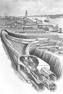
The North River Tunnels are a pair of rail tunnels that carry Amtrak and New Jersey Transit passenger lines under the Hudson River between Weehawken, New Jersey, and Pennsylvania Station in Manhattan, New York City, New York. Built between 1904 and 1908 by the Pennsylvania Railroad (PRR) to allow its trains to reach Manhattan, they opened for service in late 1910.

Paterson Plank Road is a road that runs through Passaic, Bergen and Hudson Counties in northeastern New Jersey. The route, originally laid in the colonial era, connects the city of Paterson and the Hudson River waterfront. It has largely been superseded by Route 3, but in the many towns it passes it has remained an important local thoroughfare, and in some cases been renamed.

<span class="mw-page-title-main">Hackensack Plank Road</span>

The Hackensack Plank Road, also known as Bergen Turnpike, was a major artery which connected the cities of Hoboken and Hackensack, New Jersey. Like its cousin routes, the Newark Plank Road and Paterson Plank Road, it travelled over Bergen Hill and across the Hackensack Meadows from the Hudson River waterfront to the city for which it was named. It was originally built as a colonial turnpike road as Hackensack and Hoboken Turnpike. The route mostly still exists today, though some segments are now called the Bergen Turnpike. It was during the 19th century that plank roads were developed, often by private companies which charged a toll. As the name suggests, wooden boards were laid on a roadbed in order to prevent horse-drawn carriages and wagons from sinking into softer ground on the portions of the road that passed through wetlands. The company that built the road received its charter on November 30, 1802. The road followed the route road from Hackensack to Communipaw that was described in 1679 as a "fine broad wagon-road."

<span class="mw-page-title-main">Bergen Hill</span> Lower part of the Hudson Palisades, New Jersey, United States

Bergen Hill refers to the lower Hudson Palisades in New Jersey, where they emerge on Bergen Neck, which in turn is the peninsula between the Hackensack and Hudson Rivers, and their bays. In Hudson County, it reaches a height of 260 feet.

<span class="mw-page-title-main">Hudson River Waterfront Walkway</span> Park in the United States of America

The Hudson River Waterfront Walkway, also known as the Hudson River Walkway, is a promenade along the Hudson Waterfront in New Jersey. The ongoing and incomplete project located on Kill van Kull and the western shore of Upper New York Bay and the Hudson River was implemented as part of a New Jersey state-mandated master plan to connect the municipalities from the Bayonne Bridge to the George Washington Bridge with an urban linear park and provide contiguous unhindered access to the water's edge.

<span class="mw-page-title-main">Passaic–Bergen–Hudson Transit Project</span>

The Passaic–Bergen–Hudson Transit Project is a project under study by NJ Transit to reintroduce passenger service on a portion of the New York, Susquehanna and Western Railway (NYSW) right-of-way (ROW) in Passaic, Bergen and Hudson counties using newly built, FRA-compliant diesel multiple unit rail cars. Plans call for service to run from Hawthorne south through Paterson, east to Hackensack and then southeast to North Bergen, where it would join the Hudson-Bergen Light Rail (HBLR).

<span class="mw-page-title-main">Weehawken Terminal</span> Former intermodal terminal in Weehawken, New Jersey

Weehawken Terminal was the waterfront intermodal terminal on the North River in Weehawken, New Jersey for the New York Central Railroad's West Shore Railroad division, whose route traveled along the west shore of the Hudson River. It opened in 1884 and closed in 1959. The complex contained five ferry slips, sixteen passenger train tracks, car float facilities, and extensive yards. The facility was also used by the New York, Ontario and Western Railway. The terminal was one of five passenger railroad terminals that lined the Hudson Waterfront during the 19th and 20th centuries; the others were located at Hoboken, Pavonia, Exchange Place and Communipaw, with Hoboken being the only one still in use.

<span class="mw-page-title-main">Hudson Waterfront</span> Place in Hudson and Bergen

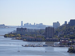
The Hudson Waterfront is an urban area of northeastern New Jersey along the lower reaches of the Hudson River, the Upper New York Bay and the Kill van Kull. Though the term can specifically mean the shoreline, it is often used to mean the contiguous urban area between the Bayonne Bridge and the George Washington Bridge that is approximately 19 miles (31 km) long. Historically, the region has been known as Bergen Neck, the lower peninsula, and Bergen Hill, lower Hudson Palisades. It has sometimes been called the Gold Coast.

<span class="mw-page-title-main">Pershing Road (Weehawken)</span> Road ascending the Hudson Palisades in Weehawken, New Jersey

Pershing Road is a road located entirely in Weehawken, New Jersey that travels for 0.42 miles (0.68 km) on the Hudson Palisades between Boulevard East and Weehawken Port Imperial, and carries the designation Hudson County Route 682. At County Route 505, the road meets 48th Street, one of the very few two-way streets in the urban grid of North Hudson, which travels west to Bergenline Avenue and Kennedy Boulevard. It is named for World War I hero John J. Pershing. Earlier names have included Clifton Road, named for the estate on whose land it was located, and Hillside Road, which would speak to its location.

<span class="mw-page-title-main">Port Imperial</span> Intermodal transit hub in Weehawken, New Jersey, US

Port Imperial is a community centered around an intermodal transit hub on the Weehawken, New Jersey, waterfront of the Hudson River across from Midtown Manhattan, served by New York Waterway ferries and buses, Hudson–Bergen Light Rail, and NJT buses. The district lies under and at the foot of Pershing Road, a thoroughfare traveling along the face of the Hudson Palisades, which rise to its west. The Hudson River Waterfront Walkway runs along the shoreline and is abutted by recently constructed residential neighborhoods, Lincoln Harbor to the south and Bulls Ferry to the north.

<span class="mw-page-title-main">North Bergen Yard</span>

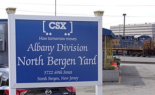
The North Bergen Yard is freight rail yard and intermodal terminal in North Bergen, New Jersey parallel to Tonnelle Avenue between 49th and 69th Streets. Located within the North Jersey Shared Assets Area, the facility is part of CSX Transportation (CSXT) and the origination point of its CSX River Subdivision at the southern end of the Albany Division. On its west side, the New York, Susquehanna and Western Railway (NYSW) runs the length of the yard and operates a bulk transloading operation immediately adjacent to it.

<span class="mw-page-title-main">Newark Drawbridge</span> Railroad bridge on the Passaic River between Newark and Harrison, New Jersey, U.S.

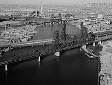
The Newark Drawbridge, also known as the Morristown Line Bridge, is a railroad bridge on the Passaic River between Newark and Harrison, New Jersey. The swing bridge is the 11th bridge from the river's mouth at Newark Bay and is 5.85 miles (9.41 km) upstream from it. Opened in 1903, it is owned and operated by New Jersey Transit.

<span class="mw-page-title-main">Edgewater Branch</span>

The Edgewater Branch was a branch of the New York, Susquehanna and Western Railway (NYS&W) that ran about 3.174 miles (5.108 km) through eastern Bergen County, New Jersey in the United States. Starting from a rail junction at the Little Ferry Yard, it went east through the Edgewater Tunnel to Undercliff to the Hudson Waterfront.

<span class="mw-page-title-main">Little Ferry Yard</span>

Little Ferry Yard is a railyard and intermodal terminal in the Port of New York and New Jersey served by the CSX River Subdivision (CSXT), New York, Susquehanna and Western Railway (NYSW), Norfolk Southern Railway and Conrail Shared Assets Operations (CRCX).

<span class="mw-page-title-main">Ridgefield Park station</span> Railroad station in New Jersey, U.S.

Ridgefield Park station, also known as West Shore Station, was a railroad station in Ridgefield Park, New Jersey, at the foot of Mount Vernon Street served by the New York, Susquehanna and Western Railroad (NYSW) and the West Shore Railroad, a division of New York Central (NYCRR). The New York, Ontario and Western Railway (NYO&W) had running rights along the West Shore and sometimes stopped at Ridgefield Park. First opened in 1872 it was one of three passenger stations in the village, the others being the Little Ferry station to the south and Westview station to the north. Service on the West Shore Railroad began in 1883. The station house, built at a cost $100,000 opened in 1927. Southbound service crossed Overpeck Creek and continued to terminals on the Hudson River waterfront where there was connecting ferry service across the Hudson River to Manhattan. Northbound near Bogota the parallel NYSW and West Shore lines diverge and continue into northern New Jersey, Pennsylvania, and upstate New York. Passenger service ended in 1966.

References

  1. 1 2 3 Bulger, Teresa D. (May 7, 2019). "Feats of Engineering: Bridging the Hackensack River and Cutting through Bergen HillDocumentation for Three Historic Resources that Help Move Commerce and Commuters throughout the Port of New York and New Jersey" (PDF). NJDOT. Retrieved May 5, 2020.
  2. "Jersey: Jersey City Bridge Profile". Shoutingthomas.typepad.com. Archived from the original on October 22, 2012. Retrieved October 23, 2012.
  3. "RIME Team wins Grand Award with the Project Team for the Lewandowski Memorial Hackensack River Bridge". Rutgers Infrastructure Monitoring and Evaluation Group/Intelligent Bridge Engineering and Advanced Materials Laboratory. June 16, 2015. Retrieved September 7, 2023.
  4. https://web.archive.org/web/20090327025729/http://www.state.nj.us/dep/hpo/1identify/lists/essex.pdf. Archived from the original (PDF) on March 27, 2009. Retrieved August 21, 2010.{{cite web}}: Missing or empty |title= (help)
  5. "Pennsylvania Railroad cut, Mt Pleasant, Jersey City, Hudson Co., New Jersey, USA". Mindat.org. October 11, 2012. Retrieved October 23, 2012.
  6. "Bergen Arches". Njcu.edu. Archived from the original on September 29, 2012. Retrieved October 23, 2012.
  7. "Stone above Long Dock Tunnel". Modelengineers.org. Archived from the original on February 29, 2012. Retrieved October 23, 2012.
  8. 1 2 French, Kenneth, Images of Rail: Railroads of Hoboken and Jersey City,Arcadia Publishing, 2002, p125, ISBN   978-0-7385-0966-2
  9. "The Bergen Hill Tunnels". Gutenberg.org. Retrieved October 23, 2012.
  10. "JFK Blvd. Bridge". Bridgehunter.com. Retrieved October 23, 2012.
  11. "Design And Construction Of The Weehawken Tunnel And Bergenline Avenue Station For The Hudson-Bergen Light Rail Transit System - Publications Index". Pubsindex.trb.org. November 2003. Retrieved October 23, 2012.
  12. "New York - West Shore & Buffalo RR tunnel, Weehawken, Bergen Hill, Hudson Co., New Jersey, USA". Mindat.org. July 30, 2012. Retrieved October 23, 2012.
  13. NJDOT Web Development Unit. "Paterson Plank Road Project Debuts in Hudson County". Nj.gov. Retrieved October 23, 2012.
  14. "The Palisades Tunnel" (PDF). The New York Times. March 17, 1893.
  15. Palisades diabase