List of districts of Kerala

Last updated

Districts of Kerala
Political map of Kerala.svg
Districts of Kerala
CategoryDistricts
Location Kerala
Number14 districts
Populations Wayanad – 846,637 (lowest);
Malappuram – 4,494,998 (highest)
Areas Alappuzha – 1,415 km2 (546 sq mi) (smallest); Idukki – 4,612 km2 (1,781 sq mi) (largest)
Government
Subdivisions

The Indian state of Kerala is divided into 14 districts. Districts are the major administrative units of a state which are further sub-divided into revenue divisions and taluks. [1]

Contents

Idukki is the largest district in Kerala with a total land area of 4612 km².

When the independent India merged smaller states together, Travancore and Cochin states were integrated to form Travancore-Cochin state on 1 July 1949. However, North Malabar and South Malabar remained under the Madras state. The States Reorganisation Act of 1 November 1956 elevated Kerala to statehood, through the unification of Malayalam-speaking territories in the southwestern Malabar Coast of India.

The state comprises three parts – the Northern Kerala districts of Kasaragod, Kannur, Wayanad, Kozhikode, Malappuram and the Central Kerala districts of Palakkad, Thrissur, Ernakulam, Idukki, Kottayam and the Southern Kerala districts of Alappuzha, Pathanamthitta, Kollam, and Thiruvananthapuram. [2] Such a regional division occurred being part of historical regions of Cochin, North Malabar, South Malabar, and Travancore. The North Malabar region, which is culturally distinct from the rest of Kerala, entirely lies in the districts of Northern Kerala. [3] North Malabar region includes Kasargod, Kannur,Wayanad,and the northern region of Kozhikode district, south Malabar region includes south-central part of Kozhikode district, Malappuram, parts except Chittoor taluk of palakkad district, Kunnamkulam and Chavakkad region of Thrissur district.The regions of South Malabar and Kingdom of Cochin, both of which share many historical, geographical, and cultural similarities, together constitute the districts of Central Kerala. [3] [4] The Travancore region is incorporated in the districts of South Kerala. [5] The Travancore region was again divided into three zones as Northern Travancore (Hill Range)(Idukki and southern portion of Ernakulam district and Kottayam district), Central Travancore (Central Range)(Kollam district, Pathanamthitta and Alappuzha district) and Southern Travancore (Southern Range)(Thiruvananthapuram). [6]

The districts in Kerala are often named after the largest town or city in the district. Some of the districts were renamed in 1990 from the anglicised names to their local names. The 14 districts are further divided into 27 revenue divisions, 77 taluks, and 1664 revenue villages.

For local governance, Kerala has 6 Municipal Corporations and 87 Municipalities overseeing urban areas. Additionally, there are 941 Gram Panchayats, 152 Block Panchayats, and 14 District Panchayats responsible for rural governance.

Administrative structure

Regional grouping of districts in Kerala Regions of Kerala.svg
Regional grouping of districts in Kerala

Kerala State has been divided into 14 districts, 27 revenue divisions, 78 taluks, 152 community development blocks, and 1664 revenue villages.

Revenue administration

A district is administered by a District Collector, who is an officer of the Indian Administrative Service (IAS) of Kerala cadre, and is appointed by the State Government of Kerala. The headquarters of the district administration is known as the Collectorate. The District Collector serves as the head of revenue administration in the district and also functions as the District Magistrate responsible for maintaining law and order within the district. The Collector serves as both the agent of the state Government and also as the representative of the people in the district. District administration is performed by the various Departments of the State Government, each of which has its own office at the district level. The District Officers of the various Departments in the district render technical advice to the collector in the discharge of his duties. The district collector is assisted by a additional district magistrate and deputy collectors.

The districts are divided into revenue divisions which comprises several taluks under its jurisdiction. Taluks comprises several revenue villages. A revenue division is headed by a Revenue Divisional Officer/Sub Collector, and taluk is headed by a Tehsildar. The Tahsildar is assisted in each revenue village by village officers and village assistants. Village offices functions as the grassroot of the revenue administration.

Local governance

For the purpose of local governance, there are local-self government institutions, which includes 941 Gram panchayats, 152 block panchayats, 14 district panchayats, 6 corporations and 87 municipalities.

The panchayati raj institutions (gram panchayats, block panchayats, district panchayats) look after the governance of the rural areas in the district. These panchayats are governed by elected councils, headed by presidents and vice presidents respectively.

The urban local bodies (municipalities and municipal corporations) look after the governance of the urban areas in the district. These urban local bodies are governed by elected municipal councils, headed by mayor/chairperson and deputy mayor/vice chairperson respectively. A municipality, which consists of urban areas, is administered by a municipal council headed by a Municipal Chairperson. In cities, a municipal corporation, administered by a corporation council headed by a Mayor, oversees the municipal affairs.

The other administrative subdivision is "blocks", which is co-terminus with the block panchayats area. Th CD blocks are established for the purpose of rural development, aligning with the boundaries of the block panchayat. Each CD Block encompasses several gram panchayats within its limit. A block is administered by a Block Development Officer (BDO), appointed by the government, who also functions as the ex-officio secretary of the Block Panchayat.

A taluk consists of urban units such as statutory towns and census towns and rural units called gram panchayats (for revenue purposes). The Local Self-Governments Department (LSGD), Government of Kerala, coordinates and supervises the administrative affairs of these local bodies and has district-level offices.

Police

There are 20 police districts in total, and among these, 8 police districts are coterminous with the respective revenue districts, while the remaining 12 police districts are constituted by bifurcating the revenue district into "city" and "rural" areas. Each police district is headed by a "District Police Chief" (DPC), an IPS officer typically holding the rank of Superintendent of Police (SP) or above. The District Police Chief is responsible for maintaining law and order, conducting criminal investigations, and overseeing police administration in the district.

These districts are further divided into police sub-divisions. A subdivision comprises several police stations under its jurisdiction, each headed by an Assistant Superintendent of Police or Deputy Superintendent of Police (DySP) designated as the sub-divisional police officer (SDPO). The police station is the basic unit of police administration at the district level, each headed by an Inspector of Police, or in the case of rural areas, by a Sub-Inspector of Police designated as the Station House Officer (SHO).

Judiciary

The Kerala High Court has the jurisdiction of the state of Kerala. Each of the districts has a District & Sessions Court.

Other

Each state government department has a district office at the district level, headed by district-level officials, such as the District Medical Officer for the health department, District Fire Officer for the Fire and Rescue Department, Divisional Forest Officer for the Forest Department, etc. Each department's district-level offices oversee their respective areas of administration. [7]

List of districts of Kerala
Districts in Kerala

History

At the time of formation, Kerala had only five districts: Malabar, Thrissur, Kottayam, Kollam, and Thiruvananthapuram.

On 1 January 1957, the Malabar district was trifurcated to form new districts of Kannur, Kozhikode, and Palakkad, bringing the total to seven districts.

Alappuzha district was carved out of erstwhile Kottayam and Kollam districts on 17 August 1957, to form the 8th district.

Ernakulam district was formed on 1 April 1958 as the 9th district, carved out of parts of erstwhile Thrissur and Kottayam districts.

Malappuram district was formed on 16 June 1969 as the 10th district, with Ernad and Tirur taluks of the erstwhile Kozhikode district and Perinthalmanna and Ponnani taluks of Palakkad district.

Idukki district was formed on 26 January 1972 as the 11th district, with Devikulam, Udumbanchola and Peermedu taluks of the erstwhile Kottayam district and Thodupuzha taluk of the erstwhile Ernakulam district.

Wayanad district was formed on 1 November 1980 as the 12th district in Kerala by carving out areas from Kozhikode and Kannur districts.

Pathanamthitta district was formed on 1 November 1982 as the 13th district by carving out the entire Pathanamthitta taluk and nine villages of Kunnathur taluk from Kollam district, entire Thiruvalla taluk and part of Chengannur and Mavelikkara taluks from Alapphuzha district and parts of Idukki district.

Kasaragod district was formed on 24 May 1984 as the 14th district by carving out a major portion of the erstwhile Kannur district.

Characteristics

Idukki district is the largest district in Kerala by area. This was accomplished by transferring land from Kuttampuzha panchayat in Ernakulam district to Edamalakudy panchayat in Idukki district, totaling 12,718.5095 hectares. [8] Alappuzha district is noted for its small area, while Malappuram district stands out as the most populous in Kerala. Wayanad, Idukki, and Kasargod are the least populated districts in the state. Ernakulam district stands out as the most urbanized in Kerala, housing a municipal corporation and 11 municipalities, with 68.07% of its population residing in urban areas. Thiruvananthapuram has the highest population density at 1509 persons per sq.km, followed closely by Alappuzha and Kozhikode districts. [9] [10] [11]

Alphabetical listing

Code [12] DistrictHeadquarters [13] Established [14] Population (2018) [15] Area [16] SubdivisionsLocation
ALA Alappuzha Alappuzha 17 Aug 1957 [17] 2,146,0331,415 km2 (546 sq mi)
ERN Ernakulam Kakkanad 1 Apr 1958 [18] 3,427,6592,924 km2 (1,129 sq mi)
IDU Idukki Painavu 26 Jan 1972 [20] [21] 1,093,1564,612 km2 (1,781 sq mi)
KAN Kannur Kannur 1 Jan 1957 [22] 2,615,2662,966 km2 (1,145 sq mi)
KAS Kasaragod Kasaragod 24 May 1984 [23] [24] 1,390,8941,989 km2 (768 sq mi)
KOL Kollam Kollam 1 Nov 1956 [26]
( 1 July 1949) [27] [28]
2,659,4312,483 km2 (959 sq mi)
KOT Kottayam Kottayam 1 Nov 1956 [30]
(1 July 1949 ) [27]
1,983,5732,206 km2 (852 sq mi)
KOZ Kozhikode Kozhikode 1 Jan 1957 [32] 3,249,7612,345 km2 (905 sq mi)
MAL Malappuram Malappuram 16 Jun 1969 [34] 4,494,9983,554 km2 (1,372 sq mi)
PAL Palakkad Palakkad 1 Jan 1957 [35] 2,952,2544,482 km2 (1,731 sq mi)
PAT Pathanamthitta Pathanamthitta 1 Nov 1982 [38] [39] 1,172,2122,652 km2 (1,024 sq mi)
THI Thiruvananthapuram Thiruvananthapuram 1 Nov 1956 [41]
(1 July 1949) [27]
3,355,1482,189 km2 (845 sq mi)
THR Thrissur Thrissur 1 Nov 1956 [42]
(1 Jul 1949) [27]
3,243,1703,027 km2 (1,169 sq mi)
WAY Wayanad Kalpetta 1 Nov 1980 [43] 846,6372,130 km2 (820 sq mi)
Total 14 14 1434,630,19238,852 km2 (15,001 sq mi) 78

See also

Related Research Articles

<span class="mw-page-title-main">Kottayam district</span> District in Kerala, India

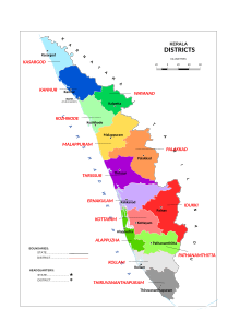
Kottayam is one of 14 districts in the Indian state of Kerala. Kottayam district comprises six municipal towns: Kottayam, Changanassery, Pala, Erattupetta, Ettumanoor, and Vaikom. It is the only district in Kerala that does not border the Arabian Sea or any other Indian state.

<span class="mw-page-title-main">Pathanamthitta district</span> District in Kerala, India

Pathanamthitta District, is one of the 14 districts in the Indian state of Kerala. The district headquarters is in the town of Pathanamthitta. There are four municipalities in Pathanamthitta: Adoor, Pandalam, Pathanamthitta and Thiruvalla.

<span class="mw-page-title-main">Wayanad district</span> District in Kerala, India +91

Wayanad is a district in the north-east of the Indian state of Kerala, with administrative headquarters at the municipality of Kalpetta. It is the only plateau in Kerala. The Wayanad Plateau forms a continuation of the Mysore Plateau, the southern portion of Deccan Plateau which links the Western Ghats with the Eastern Ghats. It is set high in the Western Ghats with altitudes ranging from 700 to 2,100 meters. Vellari Mala, a 2,240 m (7,349 ft) high peak situated on the trijunction of Wayanad, Malappuram, and Kozhikode districts, is the highest point in Wayanad district. The district was formed on 1 November 1980 as the 12th district in Kerala, by carving out areas from Kozhikode and Kannur districts. An area of 885.92 km2 in the district is forested. Wayanad has three municipal towns—Kalpetta, Mananthavady and Sulthan Bathery. There are many indigenous tribes in this area. The Kabini River, a tributary of Kaveri River, originates at Wayanad. Wayanad district, along with the Chaliyar valley in the neighbouring Nilambur in Malappuram district, is known for natural gold fields, which are also seen in other parts of the Nilgiri Biosphere Reserve. Chaliyar river, which is the fourth longest river of Kerala, originates on the Wayanad plateau. The historically important Edakkal Caves are located in Wayanad district.

<span class="mw-page-title-main">Palakkad district</span> District in Kerala, India

Palakkad is one of the 14 districts in the Indian state of Kerala. It was carved out of the southeastern region of the former Malabar District on 1 January 1957. It is located at the central region of Kerala and is the second largest district in the state after Idukki. The city of Palakkad is the district headquarters. Palakkad is bordered on the northwest by the Malappuram district, on the southwest by the Thrissur district, on the northeast by Nilgiris district, and on the east by Coimbatore district of Tamil Nadu. The district is nicknamed "The granary of Kerala". Palakkad is the gateway to Kerala due to the presence of the Palakkad Gap, in the Western Ghats. The 2,383 m high Anginda peak, which is situated in the border of Palakkad district, Nilgiris district, and Malappuram district, in Silent Valley National Park, is the highest point of elevation in Palakkad district. Palakkad city is about 347 kilometres (216 mi) northeast of the state capital, Thiruvananthapuram.

<span class="mw-page-title-main">Idukki district</span> District in Kerala, India

Idukki is one of the 14 districts in the Indian state of Kerala in the southwest of the country. It is the largest district in Kerala and lies amid the Cardamom Hills of Western Ghats in Kerala. Idukki district contains two municipal towns – Kattappana and Thodupuzha, and five taluks.

<span class="mw-page-title-main">Malabar District</span> Administrative district of Bombay and later Madras from 1792 to 1956

Malabar District, also known as Malayalam District, was an administrative district on the southwestern Malabar Coast of Bombay Presidency (1792–1800), Madras Presidency (1800–1937), Madras Province (1937–1950) and finally, Madras State (1950–1956) in India. It was the most populous and the third-largest district in the erstwhile Madras State. The historic town of Calicut was the admisnitrative headquarters of this district.

<span class="mw-page-title-main">Adoor</span> Municipality in Kerala, India

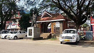
Adoor is a municipality in the Pathanamthitta district of Kerala, India. It is the headquarters of the Adoor Taluk and Adoor Revenue Division. Adoor is located 18 km (11.2 mi) southwest of the district headquarters Pathanamthitta and 85 km (52.8 mi) north of the state capital Thiruvananthapuram.

<span class="mw-page-title-main">Kerala Agricultural University</span> University in Kerala

Kerala Agricultural University (KAU) is a state university for agricultural education, recognised as a State Agricultural University by the Indian Council of Agricultural Research (ICAR). It is situated in Vellanikkara, Kerala, India.

<span class="mw-page-title-main">Government of Kerala</span> Indian State Government

The Government of Kerala, also known as the Kerala Government, is the administrative body responsible for governing Indian state of Kerala. The government is led by a chief minister, who selects all the other ministers. The chief minister and their most senior ministers belong to the supreme decision-making committee, known as the cabinet.

The Indian state of Kerala borders with the states of Tamil Nadu on the south and east, Karnataka on the north and the Arabian Sea coastline on the west. The Western Ghats, bordering the eastern boundary of the State, form an almost continuous mountain wall, except near Palakkad where there is a natural mountain pass known as the Palakkad Gap.[1] When the independent India amalgamated small states together, Travancore and Cochin states were integrated to form Travancore-Cochin state on 1 July 1949. However, Malabar remained under the Madras province. The States Reorganisation Act of 1 November 1956 elevated Kerala to statehood.

<span class="mw-page-title-main">Outline of Kerala</span> Overview of and topical guide to Kerala

The following outline is provided as an overview of and topical guide to Kerala:

<span class="mw-page-title-main">Territories of Catholic dioceses in India</span>

This article gives a list of the territories of the dioceses of the Catholic Church in India.

The Kerala Urban Road Transport Corporation (KURTC) was a state-run bus company which started with more than 500 low-floor buses in Kerala. KURTC used to run complete and individual services in Thiruvananthapuram & Ernakulam districts. The remaining 12 districts were divided into 5 clusters ; Cluster I comprises Kozhikode, Wayanad and Malappuram; Cluster II Kottayam, Thodupuzha, and Pathanamthitta; Cluster III Kannur and Kasaragod; Cluster IV Thrissur and Palakkad; and Cluster V Kollam and Alappuzha. COVID gravely affected the profitability and sustenance of this service, and the buses got rusted due to non usage and only 97 were functional out of which 70 were then given to City Circular Bus service. KURTC shut down all operations in 2022. Even their official website www.kurtc.in was closed down, thus signaling the end of a golden era of cheap and convenient transport service for customers.

<span class="mw-page-title-main">MyG</span> Indian consumer electronics retailer

myG (myG India Private Limited) is a retailer of home and kitchen appliances as well as digital gadgets headquartered in Kozhikode, founded in 2006. Currently, they have multiple stores across Kerala, including all districts Kasaragod, Kannur, Wayanad, Kozhikode, Malappuram, Palakkad, Thrissur, Ernakulam, Idukki, Kottayam, Alappuzha, Pathanamthitta, Kollam and Thiruvananthapuram. myg.in is their own online shopping portal for consumers to book orders and get it delivered at their door step with myG 2Fast or Standard Delivery. myG Targets 5000Cr business turnover by 2025.

<span class="mw-page-title-main">Kerala Bank</span> Indian bank based in Kerala

Kerala State Co-operative Bank Limited, branded as Kerala Bank, is a co-operative bank set up by the Government of Kerala, India.

References

  1. "Revenue administration (Department of Revenue, Government of Kerala)".
  2. "Central Kerala". Kerala Tourism. Retrieved 12 January 2024.
  3. 1 2 William Logan (1887). Malabar Manual (Volume-I). Madras Government Press.
  4. C. Achutha Menon (1911). The Cochin State Manual. Cochin Government Press.
  5. V. Nagam Aiya (1906). The Travancore State Manual. Travancore Government Press.
  6. J.B.C. (September 1953). "State of Travancore-Cochin. The Travancore-Cochin Legislative Assembly Manual. (Ernakulam: Government Press. 1952. Pp. xii, 132.)". American Political Science Review. 47 (3): 903–903. doi:10.1017/s0003055400301198. ISSN   0003-0554.
  7. Stateitcell. "Structure". www.clr.kerala.gov.in. Retrieved 11 May 2024.
  8. Bureau, The Hindu (11 September 2023). "Idukki once again becomes the biggest district in State". The Hindu. ISSN   0971-751X . Retrieved 26 March 2024.
  9. Bureau, The Hindu (11 September 2023). "Idukki once again becomes the biggest district in State". The Hindu. ISSN   0971-751X . Retrieved 26 March 2024.
  10. "Urbanization in Kerala".
  11. "Economic review, 2017 State Planning Board, Government of Kerala".
  12. "NIC Policy on format of e-mail Address: Appendix (2): Districts Abbreviations as per ISO 3166–2" (PDF). Ministry Of Communications and Information Technology, Government of India. 10 August 2004. pp. 5–10. Archived from the original (PDF) on 11 September 2008. Retrieved 24 November 2008.
  13. "Districts : Kerala". Government of India portal. Retrieved 11 March 2009.
  14. Here 'Established' means the year of establishment as a district of Kerala. If the district was formed earlier than the formation of the state of Kerala, 1 Nov 1956 will be considered as the day of establishment of the district.
  15. Annual Vital Statistics Report - 2018 (PDF). Thiruvananthapuram: Department of Economics and Statistics, Government of Kerala. 2020. p. 55.
  16. "Part I: state" (PDF). Government of India Census portal. Retrieved 8 December 2015.
  17. 1 2 "Alappuzha : History". alappuzha.nic.in. Archived from the original on 10 April 2009. Retrieved 11 March 2009.
  18. "History of Ernakulam". ernakulam.nic.in ( Ministry of Communication & Information Technology, Govt. of India). Archived from the original on 15 November 2007. Retrieved 11 March 2009.
  19. "Taluks — Ernakulam District". ernakulam.nic.in. Archived from the original on 27 February 2009. Retrieved 11 March 2009.
  20. "IDUKKI : History". idukki.nic.in ( Ministry of Communication & Information Technology, Govt. of India). Retrieved 11 March 2009.
  21. as per Government notification No 54131/C2/71/RD dated 24 January 1972, Government of Kerala
  22. 1 2 "Kannur district : Administration". knr.kerala.gov.in ( Govt. of Kerala). Archived from the original on 21 April 2009. Retrieved 11 March 2009.
  23. "District came into existence..." kasargod.nic.in. Archived from the original on 10 April 2009. Retrieved 11 March 2009.
  24. As per GO.(MS)No.520/84/RD dated 19.05.1984, Government of Kerala
  25. "Kasaragod District > taluks". kasargod.nic.in. Retrieved 11 March 2009.
  26. "Short History of Kollam". kollam.nic.in. Archived from the original on 18 May 2011. Retrieved 11 March 2009.
  27. 1 2 3 4 Note: This date means the day when the district was initially formed, even before the formation of the state of Kerala. Hence 1 Nov 1956 will be considered as the day of formation of district in the state of Kerala
  28. Paravur, Kollam
  29. "Taluks and Villages". Kollam.nic.in. Archived from the original on 10 February 2007. Retrieved 11 March 2009.
  30. "District Handbooks of Kerala KOTTAYAM" (PDF). kerala.gov.in. Archived from the original (PDF) on 19 March 2009. Retrieved 11 March 2009.
  31. "KOTTAYAM : Short History". Kerala.gov.in. Retrieved 12 March 2009.
  32. "Kozhikode: History". kozhikode.nic.in. Archived from the original on 2 April 2007. Retrieved 12 March 2009.
  33. "Kozhikode: Administration". kozhikode.nic.in. Archived from the original on 7 February 2009. Retrieved 12 March 2009.
  34. 1 2 "Malappuram: HISTORY". malappuram.nic.in. Retrieved 12 March 2009.
  35. "Welcome to Palghat". palghat.net. Retrieved 12 March 2009.
  36. "BASIC STATISTICS of PALAKKAD". palakkad.nic.in. Archived from the original on 10 April 2009. Retrieved 12 March 2009.
  37. https://www.mathrubhumi.com  › news അട്ടപ്പാടി ട്രൈബൽ താലൂക്ക് ... - Mathrubhumi
  38. "Pathanamthitta : History". pathanamthitta.nic.in. Archived from the original on 10 April 2009. Retrieved 12 March 2009.
  39. As per GO (MS) No.1026/82/(RD) dated 29.10.1982, Government of Kerala
  40. "Pathanamthitta : Administration". pathanamthitta.nic.in. Archived from the original on 10 April 2009. Retrieved 12 March 2009.
  41. "THIRUVANANTHAPURAM". Archived from the original on 7 February 2009. Retrieved 12 March 2009.
  42. 1 2 "Thrissur At A Glance". thrissur.nic.in. Retrieved 12 March 2009.
  43. 1 2 "Wayanad :profile". wayanad.nic.in. Retrieved 12 March 2009.

Further reading