Kasaragod is a municipal town and administrative headquarters of Kasaragod district in the state of Kerala, India. Established in 1966, Kasaragod was the first municipal town in the district. It is the northernmost district of Kerala and is also known as Saptha Bhasha Sangama Bhoomi.

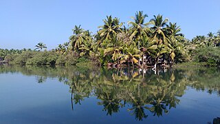
The Kerala backwaters are a network of brackish lagoons and canals lying parallel to the Arabian Sea of the Malabar coast of Kerala state in south-western India. It also includes interconnected lakes, rivers, and inlets, a labyrinthine system formed by more than 900 km (560 mi) of waterways, and sometimes compared to bayous. The network includes five large lakes linked by canals, both man made and natural, fed by 38 rivers, and extending virtually half the length of Kerala state. The backwaters were formed by the action of waves and shore currents creating low barrier islands across the mouths of the many rivers flowing down from the Western Ghats range. In the midst of this landscape there are a number of towns and cities, which serve as the starting and end points of backwater cruises. There are 34 backwaters in Kerala. Out of it, 27 are located either closer to Arabian Sea or parallel to the sea. The remaining 7 are inland navigation routes.
Vengara is a Place in Kannur District, Kerala, India that is known for its landscapes and lush greenery. The village is between the Arabian Sea and Ezhimala Hill. It is a part of Madayi Gramapanchayath

Payyanur, is a municipal town and a taluk, a sub-district administrative unit, in the Kannur district of Kerala, India. On 10 March 2018, Kerala Chief Minister Pinarayi Vijayan inaugurated Payyanur as the fifth taluk in the district. Payyanur taluk comprises 22 villages including 16 de-linked from the Taliparamba taluk and six from the Kannur taluk. The town is situated on the banks of the Perumba River.

Ezhimala, a hill reaching a height of 286 metres (938 ft), is located near Payyanur, in Kannur district of Kerala, south India. It is a part of a conspicuous and isolated cluster of hills, forming a promontory, 38 km (24 mi) north of Kannur (Cannanore). The Indian Naval Academy at Ezhimala is the Asia's largest, and the world's third-largest, naval academy.
Kandankali is a village in Kerala, India. The village is situated about two kilometers south of the town of Payyanur in Kannur district.
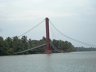
Valiyaparamba is a coastal island in Hosdurg taluk, Kasaragod district, Kerala state, India.

Kasaragod is one of the 14 districts in the southern Indian state of Kerala. Its northern border Thalappady is located just 10 km south to Ullal, which is the southernmost portion of the major port city Mangalore, on the southwestern Malabar coast of India.

Cherupuzha is a town in Kannur district, Kerala, India. It is the headquarters of the Cherupuzha Panchayat which is a special grade panchayat in Kerala.

Cherukunnu is a census town in Kannur district in the Indian state of Kerala. Cherukunnu town is located on Valapattanam-Pappinisseri-Pazhayangadi main road, situated to the south of the Pazhayangadi in Kannur District of North Malabar region in Kerala.

Kunhimangalam is a census town situated in the northern coastal part of Kannur District in Kerala state on the outskirt of Payyanur. The population in 2011 was around 19,000 including Hindus, Christians and Muslim residents. The village lies in an agricultural region.

Ramanthali is a village in Kannur district in the Indian state of Kerala. It boasts the gateway for Indian Naval Academy in Ezhiamala.

The Indian Naval Academy is the defence service training establishment for officer cadre of the Indian Naval Service and the Indian Coast Guard, located in Ezhimala, Kannur district, Kerala. Situated between Ezhimala hill and the Kavvayi backwaters, INA has a 7 kilometre beach front on the Laccadive Sea. It conducts basic training for all officers inducted into the Indian Navy and Indian Coast Guard. It is Asia's largest, and the world's third-largest, naval academy.

Pilathara is a suburb town of Payyannur in the Kannur district of Kerala, India. This region is noted for its cultural, traditional and religious characteristics. The Government Medical College, Kannur aka Pariyaram Medical College is just 4 km away from Pilathara. Pazhayangadi and Mathamangalam are located south and north of Pilathara respectively. It comes under Payyanur taluk and Cheruthazham village. Kannur International Airport is the nearest airport of about 50 km away. The nearby railway station is at Pazhayangadi, just 8 km away from Pilathara town.
Kottappuram or Kasargod district, north Kerala, India, is a backwater destination, which is also known as "Valiyaparamba backwaters". Kottappuram is situated 40 km south of Kasaragod, a part of nileshwar municipality. Nearest town is Nileshwar
Kannur, India has a number of tourist attractions including beaches, hills, temples and other monuments.

Olayambadi is a small village about 21 km from Payyanur town in the Kannur district of Kerala state, South India.
Waterways have always been an important mode of transport in Kerala. The total length of navigable route in Kerala was 1,900 kilometres and the navigable rivers constitute about 54 per cent of the waterways. The 41 West-flowing rivers together with the backwaters are an integrated part of the inland navigation system in Kerala. In Kerala water transportation through these channels are mainly small distant passenger services, informal country boats, freight transportation to PSU's such as Fertilisers and Chemicals Travancore, Kochi etc.

Kavvayi is a group of small islands, near Payyanur in the Kannur district of Kerala. The island is surrounded by Kavvayi Backwaters.