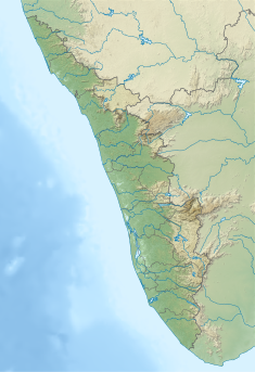
Periyar, IPA:[peɾijɐːr], is the longest river and the river with the largest discharge potential in the Indian state of Kerala. It is one of the few perennial rivers in the region and provides drinking water for several major towns. The Periyar is of utmost significance to the economy of Kerala. It generates a significant proportion of Kerala's electrical power via the Idukki Dam and flows along a region of industrial and commercial activity. The river also provides water for irrigation and domestic use throughout its course besides supporting a rich fishery. Due to these reasons, the river has been named the "Lifeline of Kerala". Kochi city, in the vicinity of the river mouth, draws its water supply from Aluva, an upstream site sufficiently free of seawater intrusion. Twenty five percent of Kerala's industries are along the banks of the Periyar. These are mostly crowded within a stretch of 5 kilometres (3 mi) in the Eloor-Edayar region (Udhyogamandal), about 10 kilometres (6 mi) north of Kochi harbor.

Chalakudy River or Chalakudy Puzha is the fifth longest river in Kerala, India. The river flows through Thrissur district, Palakkad district and Ernakulam district of Kerala. The total drainage area of the river is 1704 km2. Out of this, 1404 km2 lies in Kerala and the rest in Tamil Nadu. The length of the river is 145.5 km. Though Chalakudy River in strict geological sense is a tributary of the Periyar river, for all practical purposes it is treated as a separate river by Government and other agencies. The river has gained its name since it flows along the banks of the Chalakudy Town, the major settlement along the course of the river. It is perhaps the most unpolluted and pristine river in the state and even in India due to the limited amount of industries and wastage disposal around it. Chalakudy River and its basin area were one of the most affected rivers during the 2018 Kerala floods.
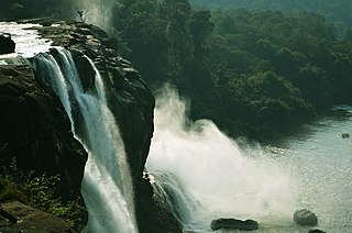
Athirappilly is a first grade Grama Panchayath with 489.00 km2 area in Chalakudy Taluk, Thrissur district in Kerala, India. It is located 60 km from Thrissur city, 70 km northeast of Kochi city, 55 km northeast of Cochin International Airport, and 30 km from Chalakudy town.

The Indian state Himachal Pradesh has a large number hydroelectricity resources, about twenty five percent of the national potential. About 27,436 MW of hydroelectric power can be generated in the state by the construction of various hydroelectric projects on the five perennial river basins. Out of total hydroelectric potential of the state, 10,519 MW is harnessed so far, out of which 7.6% is under the control of Himachal Pradesh Government while the rest is exploited by the Central Government. The state government has been giving the highest priority for its development, since hydroelectric generation can meet the growing need of power for industry, agriculture and rural electrification. It is also the biggest source of income to the state as it provides electricity to other states.

Solaiyar Dam, Upper Solaiyar Dam or Upper Sholayar Dam is located 20 km (12 mi) from Valparai, a hill station in the Anaimalai Hills of the Coimbatore district, Tamil Nadu India. As it is a part of the hydroelectric project of Tamil Nadu, special permission is required to visit the dam.

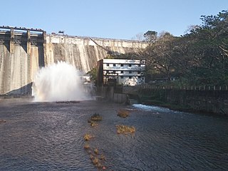
Sholayar Dam is a concrete dam built across the Chalakkudi River in Malakkappara in Thrissur district, Kerala of India. The dam consists of main Sholayar Dam, Sholayar Flanking and Sholayar Saddle Dam. It also contains Sholayar Hydro Electric Power Project of KSEB who owns the dam. Total installed capacity of the project is 54MW with 3 penstock pipes. The maximum storage capacity is 2663 feet. Sholayar is 65 km from Chalakudy town. The dam above Sholayar dam was Upper Solaiyar Dam owned by Tamil Nadu.
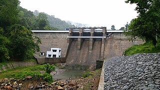
Chimmini Dam is situated in Echippara in Chalakudy taluk of Thrissur District of Kerala state of India. It is constructed across Kurumali river, a tributary of the Karuvannur river. Chimmini is the largest dam of Thrissur district. The Chimminy Wild Life Sanctuary is located close to the dam. Construction of the 495-metre masonry and 686-metre earthen dam started in 1975 and it was completed in 1996. Total cost of the project was Rs 59.71 crore although the cost of construction of the dam was initially estimated at Rs 36.15 crore.

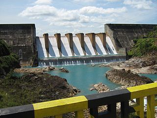
Idamalayar Dam is a multipurpose concrete gravity dam located at Ennakkal between Ayyampuzha and Bhoothathankettu in Ernakulam district of Kerala on the Idamalayar, a tributary of the Periyar River in Kerala, South India. The dam however extends east as far as Malakkappara. Completed in 1985, with a length of 373 metres (1,224 ft) and a height of 102.8 metres (337 ft), the dam created a multipurpose reservoir covering 28.3 km2 (10.9 sq mi) in the scenic hills of the Anamalais.

The Koyna Hydroelectric Project is the second largest hydroelectric power plant in India, just after the Tehri Dam Project. It is a complex project with four dams including the largest dam on the Koyna River, Maharashtra, hence the name Koyna Hydroelectric Project. The project site is in Satara district.

Kulamavu Dam is a gravity/masonry dam on Kilivillithode, which is a tributary of the Periyar river in Arakkulam village, Idukki district in the Indian state of Kerala. It is one of three dams associated with the Idukki hydroelectric power project in the Indian state of Kerala. This dam is located towards the western side of the Idukki Arch Dam. This is a gravity dam with the top portion in concrete and the bottom in masonry.

Kakki Dam is a concrete gravity dam built on the Kakki river, a tributary of the Pampa river in the Ranni forest in the Seethathodu panchayat of Pathanamthitta district in Kerala, India. The dam is located in a forested area adjacent to the Periyar National Park. It was built in 1966 as part of the Sabarigiri Hydroelectric Project. The water sources of the dam are from the Pampa dam and the Kakki river. The Sabarigiri project envisaged creation of two reservoirs which are Pamba and Kakki reservoirs and connecting these together to form a single source of water. The water from Pamba reservoir is connected to the Kakki reservoir through an underground tunnel of length 3.21 km. The intake of the Sabarigiri Powerhouse is from Kakki reservoir. The dam is 336 metres (1,102 ft) long and 116 metres (381 ft) high and is located at an elevation of 981.45 metres (3,220.0 ft) above sea level. The release flows through Ranni, Konni, Kozhencherry, Thiruvalla, Chengannur, Kuttanadu, Mavelikara and Karthikappally taluks before emptying into the Vembanad lake.
Kopili Hydro Electric Project is a 275 megawatts (369,000 hp), hydroelectric power project on the Kopili river and its tributary, Umrong stream. It is located in Dima Hasao district of Assam state in India. The project is developed and operated by North Eastern Electric Power Corporation Limited. It is an important project since the Indian state of Assam, Arunachal Pradesh, Manipur, Meghalaya, Mizoram, Nagaland and Tripura benefit from this project.

The Lower Periyar Dam is a dam built on the Periyar River as part of the Lower Periyar Hydroelectric Project in Kanjikuzhi Panchayat, Idukki District, Kerala. The dam was built to generate electricity. The lower Periyar dam is at Pambla, five kilometres downstream from where Muthirapuzha merges with main river. This 32.36-metre-high dam made of concrete has a width of 284 meters. The powerhouse is at Karimanal, near Neriamangalam, where three generators are installed with a power production capacity of 60 MW each, or a cumulative 180 MW. The Dam was completed in the year 1998 Taluks through which release flow are Idukki, Kothamangalam, Muvattupuzha, Kunnathunadu, Aluva, Kodungalloor and Paravur.
Azhutha Dam is a small diversion dam built on the Azhutha River which is a tributary of the Pamba River, at Azhutha in Peerumed Grama Panchayat of Idukki District, Kerala, India. It is a small concrete gravity dam that is only 72 metres (236 ft) long and 14 metres (46 ft) high. It acts mainly as a diversion dam to supply water to the Idukki Dam. The Azhutha Dam was constructed as an augmentation dam for the Idukki Hydro Electric Project. Construction of the project started in 1987 and was expected to be commissioned in 1991, but the project overrun and was only partially commissioned in June 1998. The year of completion was 2007. The release of the water from the dam is to Azhutha river and it flows through Ranni and Ayroor taluks.
Moozhiyar Dam is a gravity dam located close to Kakki reservoir in Seethathodu panchayath of Pathanamthitta district in Kerala, India. The Kakkad Hydroelectric Project is powered by water from the dam. The water level is set at 192.5 meters. KSEB is responsible for the maintenance of the dam and other ancillary works. The Kakkad Hydroelectric Project generates 50 MW of electricity using 2 turbines of 25 MW each year. The annual output is 262 MU. The machine was commissioned on 16 September 1999. Kakkad Hydro electric Project is the second stage development of Pamba river basin. The installed capacity is 50 MW. This scheme utilises the tail race water from Sabarigiri power station and flow received from Moozhiyar and Velluthode rivers. Two dams feed water to the powerhouse. The Moozhiyar Dam creates the main reservoir of this project. Taluks through which release flow are Ranni, Konni, Kozhencherry, Thiruvalla, Chengannur, Kuttanadu, Mavelikara and Karthikappally.

Pamba Dam is a gravity dam built on the Pamba river in the Ranni forest area of Seethathodu panchayat in Pathanamthitta district of Kerala, India. It was built in 1967 as part of the Sabarigiri Hydroelectric Project. Sabarigiri Hydro Electric Project (IHEP) is the second largest hydro electric project in Kerala. Pamba dam's reservoir is connected to the nearby Kakki dam's reservoir by a 3.21 km (1.99 mi) long underground tunnel. The dam is 281 m (922 ft) long and 57.2 m (188 ft) high and is located at an elevation of 981.45 m (3,220.0 ft) above sea level. The dam is located in a forest area adjacent to the Periyar National Park. The water stored in the Pamba and Kakki dams is conveyed to the Sabarigiri powerhouse through penstock pipes. The dam was commissioned in 1967.
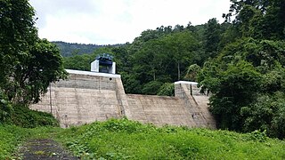
Chenkulam Dam is a gravity dam located on the Muthirapuzha river in Vellathooval panchayat of Idukki district in the Indian state of Kerala. It spans 144.50 metres (474.1 ft) long and stands 26.82 metres (88.0 ft). It hosts a 48 MW power plant.
Veluthodu dam is a part of Kakkad Hydro Electric Project and is located in Seethathode panchayath of Ranni Taluk in Pathanamthitta District of Kerala, India. It's a Concrete-Gravity dam built across the Veluthodu river, a tributary of Kakkad River which is again a tributary of Pamba River. The dam is built primarily for electricity. This diversion dam diverts water to the water conductor system from Moozhiyar reservoir to Kakkad Power Station. This power station utilises the tail race water from Sabarigiri power station and flow received from moozhiyar and velluthode rivers. After power generation, water from Kakkad power station is released to the Kakkad River. Taluks through which release flow are Ranni, Konni, Kozhencherry, Thiruvalla, Chengannur, Kuttanadu, Mavelikara and Karthikappally. It is operated by Kerala State Electricity Board.
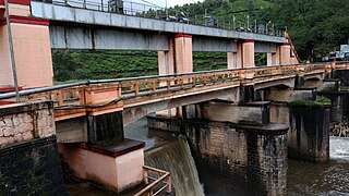
R. A. Headworks or Ramaswamy Aiyar Headworks is a masonry type weir situated in Munnar panchayath of Munnar village in Idukki district of Kerala, India impounding mudirapuzha river. It is also called as Munnar Headworks. It is a part of Pallivasal Hydro Electric Project, the first hydro power project of Kerala State. There are two dams and one diversion weir as part of this project. These are Kundala Dam, Maduppetty Dam and R. A. Head works.
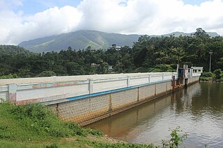
The Allunkal Dam is a concrete diversion weir built across the Kakkad River in Chittar panchayat of Ranni taluk in Pathanamthitta district of the Indian state of Kerala. The dam is 121 metres (397 ft) long and 12 metres (39 ft) tall above the bed. It is part of the Ullunkal Hydroelectric Project, a small-scale private hydroelectric project operated by EDCL Power Projects Limited, a subsidiary of Energy Development Company Limited (EDCL).
![peringng[?]kutt annkketttt.jpg](http://upload.wikimedia.org/wikipedia/commons/thumb/7/71/%E0%B4%AA%E0%B5%86%E0%B4%B0%E0%B4%BF%E0%B4%99%E0%B5%8D%E0%B4%99%E0%B5%BD%E0%B4%95%E0%B5%81%E0%B4%A4%E0%B5%8D%E0%B4%A4%E0%B5%8D_%E0%B4%85%E0%B4%A3%E0%B4%95%E0%B5%8D%E0%B4%95%E0%B5%86%E0%B4%9F%E0%B5%8D%E0%B4%9F%E0%B5%8D.jpg/220px-%E0%B4%AA%E0%B5%86%E0%B4%B0%E0%B4%BF%E0%B4%99%E0%B5%8D%E0%B4%99%E0%B5%BD%E0%B4%95%E0%B5%81%E0%B4%A4%E0%B5%8D%E0%B4%A4%E0%B5%8D_%E0%B4%85%E0%B4%A3%E0%B4%95%E0%B5%8D%E0%B4%95%E0%B5%86%E0%B4%9F%E0%B5%8D%E0%B4%9F%E0%B5%8D.jpg)