
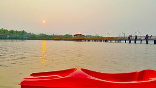
Wayanad is a district in the north-east of Indian state Kerala with administrative headquarters at the municipality of Kalpetta. It is the only plateau in Kerala. The Wayanad Plateau forms a continuation of the Mysore Plateau, the southern portion of Deccan Plateau. It is set high in the Western Ghats with altitudes ranging from 700 to 2100 meters. Vellari Mala, a 2,240 m (7,349 ft) high peak situated on the trijunction of Wayanad, Malappuram, and Kozhikode districts, is the highest point in Wayanad district. The district was formed on 1 November 1980 as the 12th district in Kerala, by carving out areas from Kozhikode and Kannur districts. An area of 885.92 km2 of the district is forested. Wayanad has three municipal towns—Kalpetta, Mananthavady and Sulthan Bathery. There are many indigenous tribes in this area. The Kabini River, a tributary of Kaveri River, originates at Wayanad. Wayanad district, along with the Chaliyar valley in neighbouring Nilambur in Malappuram district, is known for natural gold fields, which are also seen in other parts of the Nilgiri Biosphere Reserve. Chaliyar river, which is the fourth longest river of Kerala, originates on the Wayanad plateau. The historically important Edakkal Caves are located in Wayanad district.
Kannur, is one of the 14 districts along the west coast in the state of Kerala, India. The city of Kannur is the district headquarters and gives the district its name. The old name, Cannanore, is the anglicized form of the Malayalam name "Kannur". Kannur district is bounded by Kasaragod District to the north, Kozhikode district to the south, Mahé district to the southwest and Wayanad District to the southeast. To the east, the district is bounded by the Western Ghats, which forms the border with the state of Karnataka. The Arabian Sea lies to the west. Paithalmala is the highest point in Kannur District (1,372m). Enclosed within the southern part of the district is the Mahé district of the Union Territory of Puducherry. The district was established in 1957.
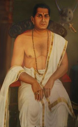
Pazhassi Raja was known as Kerala Varma and was also known as Cotiote Rajah and Pychy Rajah. He was a warrior Hindu prince and de facto head of the kingdom of Kottayam, otherwise known as Cotiote, in Malabar, India, between 1774 and 1805. His struggles with the British East India Company is known as the Cotiote War. He earned the epithet "Kerala Simham" on account of his martial exploits.

Thalassery, formerly Tellicherry, is a municipality, Commercial City on the Malabar Coast in Kannur district, in the state of Kerala, India, bordered by the districts of Mahé (Pondicherry), Kozhikode, Wayanad, Kasaragod and Kodagu (Karnataka). Thalassery municipality has a population just under 100,000. Thalassery Heritage City has an area of 23.98 square kilometres (9.26 sq mi). Thalassery is situated in an altitude ranging from 2.5m to 30m above mean sea-level.

Kalpetta is a major town and municipality in the Wayanad district, state of Kerala, India. Kalpetta is the headquarters of Wayanad district, as well as the headquarters of Vythiri taluk. It is a bustling town surrounded by dense coffee and tea plantations and mountains. It lies on the Kozhikode-Mysore National Highway NH 766 at an altitude of about 780 m above sea level. Kalpetta is 72 km from Kozhikode and 140 km from Mysore.

Sultan Bathery is a town and municipality in Wayanad district of Kerala, India, near the borders with Tamil Nadu and Karnataka states. The largest town in Wayanad district, it is the headquarters of Sultan Bathery taluk.

Kannur, formerly known in English as Cannanore, is a city and a municipal corporation in the state of Kerala, India. It is the administrative headquarters of the Kannur district and situated 274 kilometres (170 mi) north of the major port city and commercial hub Kochi and 137 kilometres (85 mi) south of the major port city and a commercial hub, Mangalore. During the period of British colonial rule in India, when Kannur was a part of the Malabar District, the city was known as Cannanore. Kannur is the sixth largest urban agglomeration in Kerala. As of 2011 census, Kannur Municipal Corporation, the local body which administers mainland area of city, had a population of 232,486.

Mattanur, also spelled Mattannur, is a town, municipality, and an aerotropolis in Kannur district, Kerala, India. Mattanur is about 27 km east of Kannur and Thalassery, two major towns of the district.

Hariharan is an Indian film director who has directed over 50 Malayalam films. His movies mainly revolve around the cultural and relational aspects of a typical Keralite society. His most notable works include Sharapancharam (1979), Panchagni (1986), Idavazhiyile Poocha Mindappoocha (1979), Amrutham Gamaya (1987), Oru Vadakkan Veeragatha (1989), Sargam (1992), Parinayam (1994) and Pazhassi Raja (2009) which has won him wide critical acclaim. In 2019, he was awarded the J. C. Daniel Award, Kerala government's highest honour for contributions to Malayalam cinema.

Peravoor is a small town and Grama Panchayat in Kannur district of Kerala state in India. It is located 50 km (31 mi) east of Kannur and 40 km (25 mi) north east of Thalassery. And Iritty, the nearest municipality is 14 km (8.7 mi) north of Peravoor. Peravoor is situated in the Western Ghats mountain range.
Shakthan Thampuran Palace is situated in City of Thrissur in Kerala state, India. It is named as Vadakkekara Palace, was reconstructed in Kerala-Dutch style in 1795 by Ramavarma Thampuran of the erstwhile Princely State of Cochin, well as Sakthan Thampuran is preserved by Archaeological Department. The palace was converted into a museum in 2005 by State.

Hill Palace is an archaeological museum and palace located in the Tripunithura neighbourhood of Kochi city in the Indian state of Kerala. It is the largest archeological museum in the state and was the imperial administrative office and official residence of the Cochin Maharaja. Built in 1865, the palace complex consists of 49 buildings in the traditional architectural style, spreading across 54 acres (220,000 m2). The complex has an archaeological museum, a heritage museum, a deer park, a pre-historic park and a children's park. The campus of the museum is home to several rare species of medicinal plants. Presently the palace has been converted into a museum by The Kerala State Archaeology Department and is open to public. The palace is about 10 kilometres (6.2 mi) from the city centre and is reachable by road and rail.

Krishnapuram is a village in Alappuzha district in the Indian state of Kerala.
Edachena Kunkan was a Wayanad Nair noble from Tirunelli, Wayanad, Kerala, India who joined the war effort of Pazhassi Raja during the 1770s and became commander of the Raja's army. His younger brothers joined him as generals. Kunkan was a popular leader in Wayanad, gathering support from people of many classes for Raja's war against the East India Company.

Banasura Hill is one of the tallest mountains in the Western Ghats of the Wayanad district, Kerala, India. The hill is named after Banasura, a mythical character of Indian legends. It is one of the highest peaks exceeding 2,000m between Nilgiris and Himalayas after Chembra Peak.
Kerala State Department of Archaeology is the archaeology department of the Government of Kerala. It had its origins in the Travancore State Archaeology Department which was started in December 1891. It forms a part of the Ministry of Culture. The department was formed in 1962 integrating the Travancore Archaeology Department and the Archaeological Research Centre of erstwhile Kochi. The main functions of the department includes publishing of volumes on stone inscriptions discovered from various places, copying of copper plate inscriptions, conducting excavations and explorations and measures to protect historical monuments dating back to 200 BC onwards which lies scattered in different parts of the state.

Kannur, formerly known in English as Cannanore, Arabic as Kannanur, and Portuguese as Cananor, is a city and a Municipal Corporation in North Malabar region, state of Kerala, India. It is the largest city in North Malabar, which is the northernmost region of Kerala. It is sometimes identified Kolathunadu, which was ruled by the Kolathiris. In the 12th and 13th centuries there was trade with Persia and Arabia.
Wayanad district, which is home to Edakkal Caves, has human settlement from prehistoric era. Wayanad is the sole Plateau in Kerala. The tribal dialects of Wayanad like the Ravula language and the Paniya language are closely related to Malayalam.
Thalassery was a trade hub where Chinese, Arab, and Jewish traders had considerable influence in the spice market before that the Greeks and Romans was in the trade. It was the European invasion that brought significant change as they enforced the trade with their military.

The Tirurangadi Taluk Office, also known as Hajur Kacheri, is a historic building located in Tirurangadi Talk of Malappuram District in the Indian state of Kerala. It houses the Tirurangadi Taluk Office since the post-independence Malabar District or British-era Madras Presidency. The Taluk office, which was once the Hajur Kacheri under the British, was one of the major administrative centers of the British government in Malabar region. The building also functioned as the headquarters of a short-lived Khilafat government during the rebellion.

