Wayanad is a district in the north-east of the Indian state of Kerala, with administrative headquarters at the municipality of Kalpetta. It is the only plateau in Kerala. The Wayanad Plateau forms a continuation of the Mysore Plateau, the southern portion of Deccan Plateau which links the Western Ghats with the Eastern Ghats. It is set high in the Western Ghats with altitudes ranging from 700 to 2100 meters. Vellari Mala, a 2,240 m (7,349 ft) high peak situated on the trijunction of Wayanad, Malappuram, and Kozhikode districts, is the highest point in Wayanad district. The district was formed on 1 November 1980 as the 12th district in Kerala, by carving out areas from Kozhikode and Kannur districts. An area of 885.92 km2 of the district is forested. Wayanad has three municipal towns—Kalpetta, Mananthavady and Sulthan Bathery. There are many indigenous tribes in this area. The Kabini River, a tributary of Kaveri River, originates at Wayanad. Wayanad district, along with the Chaliyar valley in neighbouring Nilambur in Malappuram district, is known for natural gold fields, which are also seen in other parts of the Nilgiri Biosphere Reserve. Chaliyar river, which is the fourth longest river of Kerala, originates on the Wayanad plateau. The historically important Edakkal Caves are located in Wayanad district.

The Kerala backwaters are a network of brackish lagoons and canals lying parallel to the Arabian Sea of the Malabar coast of Kerala state in south-western India. It also includes interconnected lakes, rivers, and inlets, a labyrinthine system formed by more than 900 km (560 mi) of waterways, and sometimes compared to bayous. The network includes five large lakes linked by canals, both man made and natural, fed by 38 rivers, and extending virtually half the length of Kerala state. The backwaters were formed by the action of waves and shore currents creating low barrier islands across the mouths of the many rivers flowing down from the Western Ghats range. In the midst of this landscape there are a number of towns and cities, which serve as the starting and end points of backwater cruises. There are 34 backwaters in Kerala. Out of it, 27 are located either closer to Arabian Sea or parallel to the sea. The remaining 7 are inland navigation routes.

Periyar, IPA:[peɾijɐːr], is the longest river and the river with the largest discharge potential in the Indian state of Kerala. It is one of the few perennial rivers in the region and provides drinking water for several major towns. The Periyar is of utmost significance to the economy of Kerala. It generates a significant proportion of Kerala's electrical power via the Idukki Dam and flows along a region of industrial and commercial activity. The river also provides water for irrigation and domestic use throughout its course besides supporting a rich fishery. Due to these reasons, the river has been named the "Lifeline of Kerala". Kochi city, in the vicinity of the river mouth draws its water supply from Aluva, an upstream site sufficiently free of seawater intrusion. Twenty five percent of Kerala's industries are along the banks of river Periyar. These are mostly crowded within a stretch of 5 kilometres (3 mi) in the Eloor-Edayar region (Udhyogamandal), about 10 kilometres (6 mi) north of Kochi harbor.

Chembra Peak is a mountain in the state of Kerala, India, with an elevation of 2,100 m (6,890 ft) above sea level. The highest peak in the Wayanad hills and one of the highest peaks in the Western Ghats, adjoining the Nilgiri Hills and Vellarimala, it is located in the Wayanad district of Kerala, near the town of Meppadi and 8 km (5 mi) south of Kalpetta.
Mullaperiyar DamIPA:[mulːɐpːeɾijɐːr], is a masonry gravity dam on the Periyar River in the Indian state of Kerala It is located 881 m (2,890 ft) above the sea level, on the Cardamom Hills of the Western Ghats in Thekkady, Idukki District of Kerala, India. It was constructed between 1887 and 1895 by John Pennycuick and also reached in an agreement to divert water eastwards to the Madras Presidency area. It has a height of 53.6 m (176 ft) from the foundation, and a length of 365.7 m (1,200 ft). The Periyar National Park in Thekkady is located around the dam's reservoir. The dam is built at the confluence of Mullayar and Periyar rivers. The dam is located in Kerala on the river Periyar, but is operated and maintained by the neighbouring state of Tamil Nadu. Although the Periyar River has a total catchment area of 5398 km2 with 114 km2 downstream from the dam in Tamil Nadu, the catchment area of the Mullaperiyar Dam itself lies entirely in Kerala and thus not an inter-State river. On 21 November 2014, the water level hit 142 feet for first time in 35 years. The reservoir again hit the maximum limit of 142 feet on 15 August 2018, following incessant rains in the state of Kerala. In a UN report published in 2021, the dam was identified as one among the world's big dams which needs to be decommissioned for being 'situated in a seismically active area with significant structural flaws and poses risk to 3.5 million people if the 100+ years old dam were to fail'.

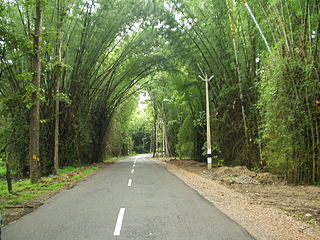
Thenmala is a tourist destination in the eastern side of Kollam district in Kerala, India that is home to the first eco-tourism centre in India. The word 'Thenmala' means "Honey hill" in Malayalam language. It is known for its high quality honey export. The town is 66 km away from Kollam city, 69km from the state capital Trivandrum and is just 14 km away from Tamil Nadu state border. The interstate National Highway-744, connecting Kollam with Madurai in Tamil Nadu, and State Highway-2 of Kerala are passing through Thenmala.

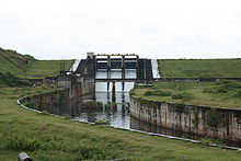
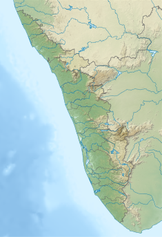
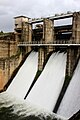
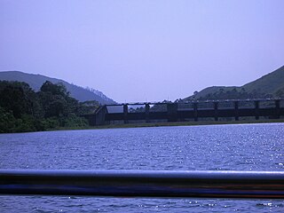
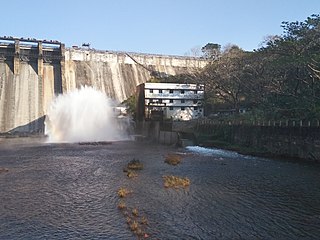
Banasura Sagar Dam, which impounds the Karamanathodu tributary of the Kabini River, is part of the Indian Banasurasagar Project consisting of a dam and a canal project started in 1979. The goal of the project is to support the Kakkayam Hydro electric power project and satisfy the demand for irrigation and drinking water in a region known to have water shortages in seasonal dry periods. The dam is also known as Kuttiyadi Augmentation Main Earthen Dam. The dam has a height of 38.5 metres (126 ft) and length of 685 metres (2,247 ft).

The Lal Bahadur Shastri Dam is also known as Almatti Dam is a hydroelectric project on the Krishna River in North Karnataka, India which was completed in July 2005. The target annual electric output of the dam is 560 MU.

Chempanoda/Chempanod is a village located in the northeastern part of the Kozhikode district of Kerala, India. It is situated near the popular tourist destination of Peruvannamuzhi.

Ambalavayal is a village in Wayanad district in the state of Kerala, India. The Wayanad Heritage Museum is located in the village.

Banasura Hill is one of the tallest mountains in the Western Ghats of the Wayanad district, Kerala, India. The hill is named after Banasura, a mythical character of Indian legends. It is one of the highest peaks exceeding 2,000m between Nilgiris and Himalayas after Chembra Peak.
Chimmini Dam is situated in Echippara in Chalakudy taluk of Thrissur District of Kerala state of India. It is constructed across Kurumali river, a tributary of the Karuvannur river. Chimmini is the largest dam of Thrissur district. The Chimminy Wild Life Sanctuary is located close to the dam. Construction of the 495-metre masonry and 686-metre earthen dam started in 1975 and it was completed in 1996. Total cost of the project was Rs 59.71 crore although the cost of construction of the dam was initially estimated at Rs 36.15 crore.

Idamalayar Dam is a multipurpose concrete gravity dam located at Ennakkal between Ayyampuzha and Bhoothathankettu in Ernakulam district of Kerala on the Idamalayar, a tributary of the Periyar River in Kerala, South India. The dam however extends east as far as Malakkappara. Completed in 1985, with a length of 373 metres (1,224 ft) and a height of 102.8 metres (337 ft), the dam created a multipurpose reservoir covering 28.3 km2 (10.9 sq mi) in the scenic hills of the Anamalais.

Meppadi is a village in the Indian state of Kerala. It is an extremely scenic hill station on the State Highway between Kozhikode and Ooty. The nearest city is Kalpetta, which is the headquarters of the Wayanad revenue district.

Meenangadi is an old town situated on the highway NH 766 between Kalpetta and Sulthan Bathery in Wayanad District, in Kerala, India. This place is one among the Provinces where the existence of Dolmens provide an historical evidence of earlier civilisation. Coffee bean, Black pepper, Ginger, Rice and Areca are the major crops cultivated in this area. Meenangadi is famous for its Fish Market and Cattle Market. The nearest railway station is at Kozhikode at 87 km and airport is Kannur International Airport with 94 km from Meenangadi. Meenangadi is surrounded by, Ambalavayal Panchayat, Kalpetta Taluk towards west, Gudalur Taluk towards East, Mananthavady Taluk towards west. Kalpetta, Sultan Bathery, Kozhikode are the nearby Cities and towns to Meenangadi.
Kerala's first carbon neutrality project launched in Meenangadi in June 2016. Upon achieving the goals of the project, Meenangadi will be the first village in India to go completely carbon neutral. Meenangadi has a population of 33450 According to 2011 Census with two Villages Purakkadi and (Part)Krishnagiri.
The Wayanad District of Kerala, India has a wide variety of tourist attractions ranging from religious sites to natural, and historical sites. This district is divided into three towns, Kalpetta, Sultan Bathery and Mananthavady. All Major Tourism destinations in the district are maintained by the District Tourism Promotion Council.

Pamba Dam is a gravity dam built on the Pamba river in the Ranni forest area of Seethathodu panchayat in Pathanamthitta district of Kerala, India. It was built in 1967 as part of the Sabarigiri Hydroelectric Project. Sabarigiri Hydro Electric Project (IHEP) is the second largest hydro electric project in Kerala. Pamba dam's reservoir is connected to the nearby Kakki dam's reservoir by a 3.21 km (1.99 mi) long underground tunnel. The dam is 281 m (922 ft) long and 57.2 m (188 ft) high and is located at an elevation of 981.45 m (3,220.0 ft) above sea level. The dam is located in a forest area adjacent to the Periyar National Park. The water stored in the Pamba and Kakki dams is conveyed to the Sabarigiri powerhouse through penstock pipes. The dam was commissioned in 1967.

Nayanmoola Saddle dam is an earthen dam constructed across Karamanthode at Thariyode village of Wayanad district in Kerala, India. It is a saddle dam of Banasura sagar reservoir built as a part of the Kuttiyadi Augmentation scheme. The dam has a height of 3.5 metres (11 ft) and a length of 24.0 metres (78.7 ft)