Palakkad is one of the 14 districts in the Indian state of Kerala. It was carved out from the southeastern region of the former Malabar District on 1 January 1957. It is located at the centre of Kerala. It is the largest district in the state since 2006. The city of Palakkad is the district headquarters. Palakkad is bordered on the northwest by the Malappuram district, on the southwest by the Thrissur district, on the northeast by Nilgiris district, and on the east by Coimbatore district of Tamil Nadu. The district is nicknamed "The granary of Kerala". Palakkad is the gateway to Kerala due to the presence of the Palakkad Gap, in the Western Ghats. The 2,383 m high Anginda peak, which is situated in the border of Palakkad district, Nilgiris district, and Malappuram district, in Silent Valley National Park, is the highest point of elevation in Palakkad district. Palakkad city is located just 50 km away from Coimbatore, a major city in Tamil Nadu state.

The Anamala or Anaimalai, also known as the Elephant Mountains, are a range of mountains in the southern Western Ghats of central Kerala and span the border of western Tamil Nadu in Southern India. The name anamala is derived from the Malayalam word aana and the Tamil word yaanai, meaning elephant, or from tribal languages. Mala or Malai means 'mountain', and thus literally translatable as 'Elephant mountain'.
Gayathripuzha River is one of the main tributaries of the Bharathapuzha River, the second-longest river in Kerala, south India. It originates from Anamala hills, passes through Kollengode, Nenmara (Nemmara), Alathur, Padur and Pazhayannur before joining the Bharathapuzha at Mayannur. It is the second largest tributary of Bharathapuzha, by both length and discharge. It flows mainly through Palakkad district, except the last few kilometres. The river is non-perennial like its parent river, and is also prone of sand mining. There is a dam built across this river at Cherakkuzhy near Pazhayannur.

Mangalam River is the main tributary of the river Gayathripuzha, which in turn is a tributary of Bharathapuzha, the second longest river in Kerala, India. It is around 30 km long in length, with its source from Nelliyampathi forests, and passing through Vadakkencherry, Kannambra, Puthucode, Padur, etc. and joining Gayathripuzha at Plazhi in the border of Thrissur and Palakkad districts.
Vandazhippuzha River is one of the tributaries of the river Gayathripuzha. It gets its name since it flows through the village of Vandazhi in Palakkad district. It has its origin from Nelliyampathy hills and joins Gayathri river near Alathur. Gayathripuzha is one of the main tributaries of the Bharathapuzha River, the second-longest river in Kerala, south India.
Chulliyar River is one of the tributaries of the river Gayathripuzha. Gayathripuzha is one of the main tributaries of the Bharathapuzha River, the second-longest river in Kerala, south India.

Walayar is a border town, located in the eastern corner of Palakkad district in Kerala, India.
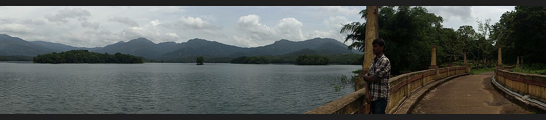
Malampuzha River is one of the tributaries of the river Kalpathipuzha. Malampuzha Dam is built across the river at Malampuzha about 8 km from the Palakkad city in the Indian state of Kerala. The reservoir formed by the Malampuzha Dam is 23.13 square kilometres in area and is the second largest reservoir in Kerala after the Idukki reservoir. The construction of Malampuzha dam started in the year 1949 and was completed in the year 1955. The project is estimated to have cost around Rs. 5.3 Crores. Malampuzha river joins Kalpathipuzha, a tributary of Bharathapuzha at Palakkad. Kalpathipuzha then flows westward to join Kannadipuzha at Parali to form Bharathapuzha, which ultimately flows until Ponnani, passing through towns and villages Mankara, Pathirippala, Lakkidi, Thiruvilwamala, Ottapalam, Mayannur, Shoranur, Cheruthuruthy, Thirumittakode, Pattambi, Thrithala, Kudallur, Kuttippuram, Thirunavaya and Chamravattom.
Cherukunnapuzha is a tributary of the river Mangalam river, passing through Alathur Taluk in Palakkad district. This river joins with some streams to form Mangalam River. Mangalam river is the largest tributary of the river Gayathripuzha which itself is one of the tributaries of the river Bharathapuzha, the second-longest river in Kerala, south India. The river joins Mangalam river near Mangalam Dam and its waters continue with Mangalam river until Plazhi in the border of Thrissur and Palakkad districts, and eventually turns to Gayathripuzha until Mayannur, where it joins Bharathapuzha, and finally reaching the Arabian Sea.
Walayar Dam is a dam in Palakkad district of Kerala, India. This dam is constructed across the Walayar River which is a tributary of Kalpathipuzha River. It was completed and opened in 1964. It is one of the major sources of irrigation in the region. Most of the water in this river is passed to the inner places of Walayar. The dam holds a larger reservoir area, and the persons living near the reservoir area utilizes the water from the walayar dam as their main water source for irrigation. Currently the water held inside the reservoir is less due to lesser rain at Walayar. The reservoir area is very scenic and has better scope for tourism.
Kizhakkancherry is a gram panchayat in the Palakkad district, state of Kerala, India. It is a local government organisation that serves the villages of Kizhakkencheri-I and Kizhakkencheri-II. It was formed in the year of 1951 and is the fourth largest grama panchayath in Kerala. It covers an area of 112.56 km2 and comprises 22 wards. The boundaries are Vadakkencherry (north), Pananjeri (south), Vandazhy (east) and Kannambra (west). The village is located 37.4 km from the city of Palakkad and 34.9 km from Thrissur.

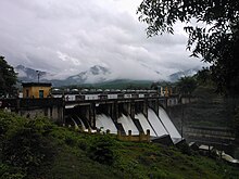
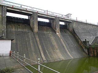
Malampuzha Dam is the second largest dam and reservoirs in Kerala, located near Palakkad, in the state of Kerala in South India, built post independence by the then Madras state. Situated in the scenic hills of the Western Ghats in the background it is a combination of a masonry dam with a length of 1,849 metres and an earthen dam with a length of 220 metres making it the longest dam in the state. The dam is 355 feet high and crosses the Malampuzha River, a tributary of Bharathappuzha, Kerala's second longest river. There is a network of two canal systems that serve the dam's reservoir of 42,090 hectares.

Mangalam Dam is a village in the Palakkad district in the state of Kerala, India. It is administered by Vandazhy gram panchayat. This village is named after the dam of the same name situated in the region.
Vandazhi-I is a village in Palakkad district in the state of Kerala, India. It is administered by Vandazhy gram panchayat, along with Mangalam Dam and Vandazhi-II.
Vandazhi-II is a village in the Palakkad district, state of Kerala, India. It is administered by Vandazhy gram panchayat, along with Mangalam Dam and Vandazhi-I.
State Highway 58 is a State Highway in Kerala, India that starts in Vadakkancherry and ends in Pollachi. The highway is 39 km long.

Bharathappuzha, also known as the Nila or Ponnani River, is a river in India in the state of Kerala. With a length of 209 km, it is the second longest river that flows through Kerala after the Periyar. It flows through Palakkad Gap, which is also the largest opening in the Kerala portion of Western Ghats. Nila has groomed the culture and life of South Malabar part of Kerala. It is also referred to as "Peraar" in ancient scripts and documents. River Bharathapuzha is an interstate river and lifeline water source for a population residing in four administrative districts, namely Malappuram and Palakkad districts, and parts of Palakkad-Thrissur district border of Kerala and Coimbatore, and Tiruppur of Tamil Nadu. The fertile Thrissur-Ponnani Kole Wetlands lie on its bank.
Vandazhy is a gram panchayat in the Palakkad district, state of Kerala, India. It is a local government organisation that serves the villages of Vandazhi-I, Vandazhi-II and Mangalam Dam.
Palakkad district has a large number of temples, churches, mosques and other tourist attractions. Palakkad district is situated in the middle of Kerala state in South India. The nearest airports are at Coimbatore in Tamil Nadu and Cochin in Kerala.
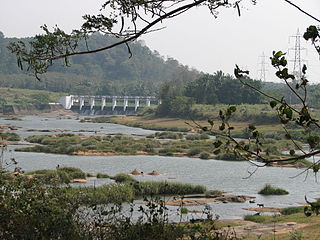
Meenkara Dam is an embankment or earthen dam built on the banks of the river Gayatripuzha, a tributary of the river Bharathapuzha, at Muthalamada in the Muthalamada Grama Panchayat near Kollengode in the Palakkad district of Kerala with masonry spillway sections. It is part of the Gayatri Irrigation Project. The project was started in 1956 and partially commissioned in 1960. The project was fully completed in 1964. The irrigation scheme has been prepared for agriculture and drinking water in Palakkad district. Farms in Chittoor, Nemmara, Alathur in Palakkad district and Vadakkancherry in Thrissur district will benefit from this irrigation scheme.