
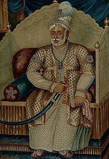
Hyder Ali was the Sultan and de facto ruler of the Kingdom of Mysore in southern India. Born as Hyder Ali, he distinguished himself as a soldier, eventually drawing the attention of Mysore's rulers. Rising to the post of Dalavayi (commander-in-chief) to Krishnaraja Wodeyar II, he came to dominate the titular monarch and the Mysore government. He became the de facto ruler of Mysore as Sarvadhikari by 1761. During intermittent conflicts against the East India Company during the First and Second Anglo–Mysore Wars, Hyder Ali was the military leader.

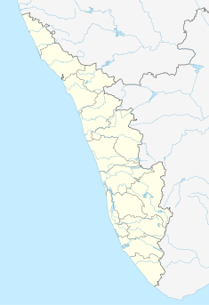
Palakkad District is one of the 14 districts in the Indian state of Kerala. It was carved out from the southeastern region of the former Malabar District on 1 January 1957. It is located at the centre of Kerala. It is the largest district in the state since 2006. The city of Palakkad is the district headquarters. Palakkad is bordered on the northwest by the Malappuram district, on the southwest by the Thrissur district, on the northeast by Nilgiris district, and on the east by Coimbatore district of Tamil Nadu. The district is nicknamed "The granary of Kerala". Palakkad is the gateway to Kerala due to the presence of the Palakkad Gap, in the Western Ghats. The 2,383 m high Anginda peak, which is situated in the border of Palakkad district, Nilgiris district, and Malappuram district, in Silent Valley National Park, is the highest point of elevation in Palakkad district. Palakkad city is located just 50 km away from Coimbatore, a major city in Tamil Nadu state.

The Kingdom of Cochin, named after the capital of Kochi, is a kingdom on Malabar Coast in Kerala that ruled from the beginning of the 12th century until 1949.
Fort Kochi, Fort Cochin in English, Cochim de Baixo in Cochin Portuguese creole, is a neighbourhood of Cochin (Kochi) city in Kerala, India. Fort Kochi takes its name from the Fort Manuel of Cochin, the first European fort on Indian soil, controlled by the Portuguese East Indies. This is part of a handful of water-bound islands and islets toward the south-west of the mainland Kochi, and collectively known as Old Cochin or West Cochin. Adjacent to this is the locality of Mattancherry. In 1967, these three municipalities along with a few adjoining areas, were amalgamated to form the Kochi Municipal Corporation.

Malabar District, also known as Malayalam District, was an administrative district on the southwestern Malabar Coast of Bombay Presidency (1792-1800) and Madras Presidency (1800-1947) in British India, and independent India's Madras State (1947-1956). It was the most populous and the third-largest district in the erstwhile Madras State. The British district included the present-day districts of Kannur, Kozhikode, Wayanad, Malappuram, Palakkad, Chavakad Taluk and parts of Kodungallur Taluk of Thrissur district, and Fort Kochi area of Ernakulam district in the northern and central parts of present Kerala state, the Lakshadweep Islands, and a major portion of the Nilgiris district in Tamil Nadu. The detached settlements of Tangasseri and Anchuthengu, which were British colonies within the kingdom of Travancore in southern Kerala, also formed part of Malabar District until 1927. Malayalam was the administrative as well as the most spoken lingua franca of Malabar District during British Rule. Jeseri, a distinct dialect of Malayalam, was spoken in the Laccadive Islands. Malabar District merged with the erstwhile state of Travancore-Cochin (1950-1956) to form Kerala according to the States Reorganisation Act, 1956. On the same day, the present Kasaragod district of South Canara District was also attached to Malabar, and the Laccadive & Minicoy Islands of Malabar were reorganised to form a new Union Territory. Malabar was trifurcated to form the districts of Kannur, Kozhikode, and Palakkad, on 1 January 1957.

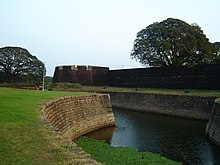
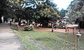
Palakkad, formerly known as Palghat, historically known as Palakkattussery is a city and municipality in the Indian state of Kerala. It is the administrative headquarters of the Palakkad District. Palakkad is most densely populated municipality and fourth densely populated city in Kerala. It was established before Indian independence under British rule and was known by the name Palghat. Palakkad is famous for the ancient Palakkad Fort, which is situated at the heart of the city and was captured and rebuilt by Hyder Ali in 1766. The city is situated about 347 kilometres (216 mi) northeast of the state capital Thiruvananthapuram.
Dharma RajaKarthika Thirunal Rama Varma was the Maharajah of Travancore from 1758 until his death in 1798. He succeeded his uncle Marthanda Varma, who is credited with the title of "maker of modern Travancore". During his reign Dharma Raja not only retained all the territories his predecessor had gained but administered the kingdom with success. He was addressed as Dharma Raja on account of his strict adherence to Dharma Sastra, the Hindu principles of justice by providing asylum to thousands of Hindus and Christians fleeing Malabar during the Mysorean conquest of Malabar.
Nedumkotta or Travancore lines was a wall built as a protection against consistent invasions from Mysore during the rule of Tipu Sultan. It was built by the Dharma Raja Karthika Thirunal, King of Travancore with the request, support and permission of the Kingdom of Kochi. It was constructed by Rama Varma under the supervision of his Commander Eustachius De Lannoy. The work was started in 1762 it was completed only by 1775. The lines consist of a ditch about sixteen feet broad and twenty feet deep with a thick bamboo hedge in it, a slight parapet and good rampart and bastions on rising grounds almost flanking each other from one extreme of the lines to the other. The construction of Nedumkotta or the Travancore Lines is considered to be a unique and unparallel episode in Indian History by historians.

The Samoothiri was the hereditary Nair monarch and ruler of the Kingdom of Kozhikode (Calicut) in the South Malabar region of India. Calicut was one of the most important trading ports on the southwest coast of India. At the peak of their reign, they ruled over a region extending from Kozhikode Kollam (Kollam) to the borders of Panthalayini Kollam (Koyilandy). The Zamorins belonged to the Eradi caste of the Samantan Nair community of medieval Kerala.
The Captivity of Nairs at Seringapatam was imposed on the Nairs of Malabar by Tipu Sultan, the de facto ruler of the Kingdom of Mysore from 1786 to 1799. They were subjected to forcible conversions to Sunni Islam, the official religious sect sanctioned by the Ottoman Caliphate, whose approval and alliance was sought by Tippu Sultan. Those who refused conversions had to face many humiliations, hardships, torture, and even death. The Nairs were treated with extreme brutality due to their strong adherence to the Hindu faith and martial tradition. The captivity ended when Nair troops from Travancore defeated Tipu in the Third Anglo-Mysore War. It is estimated that out of the 30,000 Nairs put to captivity, only a few hundred returned to Malabar alive.
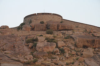
The Bellary Fort was built on top of a hill called the "Ballari Gudda" or the Fort Hill. It is situated in the historic city of Bellary, in the Bellary district, in Karnataka state, India. It was built in two parts namely, the Upper Fort and the Lower Fort. The Upper Fort was built by Hanumappa Nayaka, a feudatory of Vijayanagara Empire, but the Lower Fort was built by Hyder Ali in later part of the 18th century.
The Mysorean invasion of Malabar was the military invasion of the Malabar region of Kerala, including the territories of the Zamorin of Calicut, by the then-de facto ruler of the Kingdom of Mysore, Hyder Ali. After the invasion, the Kingdom of Cochin to the south of Malabar became a tributary state of Mysore.
The Mysore's campaigns against the states of Malabar was the result of the Calicut's attack on Palghat in 1756–1757. This comprised the attacks of the Zamorin of Calicut on the Kingdom of Palakkad, situated east to Calicut. It was a continuation of the attacks on the Kingdom of Valluvanad, the traditional rival of Calicut. In the one sided Valluvanad attacks the Zamorin had captured much of the land from Eranad to Nedunganad. So, this time Zamorin marched against Palakkad and easily occupied Nadvattom which tore the Kingdom of Palakkad right through the middle.
Ravi Varma Raja (1745–1793) was a Samantan Nair warrior prince of the Royal House of Zamorins from Calicut who fought a two-decade long revolt against the Mysore Sultanate under Hyder Ali and Tipu Sultan between 1766–1768 and 1774–1791, and later the British East India Company in 1793.

The Kozhikode, also known as Calicut, was the kingdom of the Zamorin of Calicut, in the present-day Indian state of Kerala. Present-day Kozhikode is the second largest city in Kerala, as well as the headquarters of Kozhikode district.

William Fort or locally known as Chettuva Fort is located in Chettuva, Thrissur District of Kerala, India.
Malappuram is one of the 14 districts in the South Indian state of Kerala. The district has a unique and eventful history starting from pre-historic times. During the early medieval period, the district was the home to two of the four major kingdoms that ruled Kerala. Perumpadappu was the original hometown of the Kingdom of Cochin, which is also known as Perumbadappu Swaroopam, and Nediyiruppu was the original hometown of the Zamorin of Calicut, which is also known as Nediyiruppu Swaroopam. Besides, the original headquarters of the Palakkad Rajas were also at Athavanad in the district.

Begumpur Mosque is a mosque located in Madurai Road, Begampur in Dindigul, the administrative headquarters of the Dindigul district in state of Tamil Nadu. Constructed in the Mughal architectural style, the mosque was built by Haidar Ali. The mosque is named after Ameerunnisa Begum, the younger sister of Hyder, who is buried in the mosque during 1766.
Palakkad district has a large number of temples, churches, mosques and other tourist attractions. Palakkad district is situated in the middle of Kerala state in South India. The nearest airports are at Coimbatore in Tamil Nadu and Cochin in Kerala.
Mullathpara is a village in the Palakkad district of Kerala State, South India. The headquarters is Mannarkkad Taluk. It is situated 34 km north-east of the district headquarters Palakkad, on the way to Kozhikode National Highway 213 (NH-213) and in the foothills of the Western Ghats. Silent Valley is only 45 km from Mullathpara.


