Llanafan Fawr

Last updated

Llanafan Fawr
St Afan's Church, Llanafan-Fawr - geograph.org.uk - 1468440.jpg
St Afan's Church in Llanafan Fawr
Powys UK location map.svg
Red pog.svg
Llanafan Fawr
Location within Powys
Population470 (2011) [1]
Community
  • Llanafanfawr
Principal area
Preserved county
Country Wales
Sovereign state United Kingdom
Post town Llandrindod Wells
Postcode district LD1
Police Dyfed-Powys
Fire Mid and West Wales
Ambulance Welsh
Website community council site
List of places
UK
Wales
Powys
52°11′27″N3°30′37″W / 52.1908°N 03.5102°W / 52.1908; -03.5102 Coordinates: 52°11′27″N3°30′37″W / 52.1908°N 03.5102°W / 52.1908; -03.5102

Llanafan Fawr is a village and community and ecclesiastical parish in Powys, Wales. Located in the former cantref of Buellt (Builth) and historic county of Brecknockshire, the community includes the former parish of Llanfihangel Bryn Pabuan.

Contents

The parish has an area of slightly over 5,000 hectares (12,000 acres) (about twenty square miles) and a scattered rural population of more than a thousand. It is named after Saint Afan and was the centre of Cantref Buallt in ancient times, before the building of Builth Wells about 9 miles (14 km) away. The former spa town of Llandrindod Wells is also close by.

Name

The village is also known simply as Llanafan or variantly spelled Llanafan-Fawr. In Welsh placenames, many smaller communities are named for their parish ( llan ), having grown up around the local church. This name of the village honours its patron saint Afan. "Fawr" is the mutated form of the Welsh mawr, meaning "big" or "great". The title distinguishes the community from the nearby Llanafan Fechan ("Little Llanafan"), although that village is now more often known as "Llanfechan".

History

Afan was a 6th-century saint supposedly related to the Cuneddan dynasty of Gwynedd. [2] His relics are claimed by the local church, which commemorates him as a bishop, presumably over Brycheiniog but possibly only over the local parish. The c. 1300 inscription on the tomb reads: HIC IACET SANCTUS AVANUS EPISCOPUS. [3] He was said to have been martyred on the banks of the Afon Chwefru during an attack by Irish pirates or Danes. [2]

The Llanafan Fawr Agricultural Show is held on the third Sunday in September each year.[ citation needed ].

Notable people

Governance

An electoral ward in the same name exists. The population of this ward at the 2011 census was 1,386. [5]

Church of Saint Afan

The Church of Saint Afan has been rebuilt several times. The foot of the church-tower is the only part remaining of earlier construction, the rest being rebuilt in 1886. In the porch on the right-hand wall are several carved stones which date from the 7th to 9th centuries. Inside the church, to the left of the altar, is a single pillar stone incised with a Latin ring cross, dating from the 7th century. To the right is an ancient baptismal font of similar age.

There is a 2,200-year-old yew tree in the churchyard. [6] The churchyard claims Saint Afan's relics and is also the burial place of Thomas Huet, who translated the Book of Revelation into the Welsh language in the 16th century. [7] There is also a double gravestone unique in Britain, the left-hand inscription notes that its occupant was murdered and also bears the name of his murderer: John Price Who Was Murdered On The Darren Hill In This Parish By R Lewis April 21, 1826. Relatives of both murderer and victim still live locally. [8]

Other notable sites

The Red Lion Inn is believed by some to date from at least 1188, when it was visited by Gerald of Wales. Local folklore maintains that, while staying at the inn, Gerald learned of the miracle whereby the Anglo-Norman lord Philip de Braose was struck blind and saw his hunting dogs go mad when he disrespectfully used St Afan's church as a makeshift hostel one night. [10] He was told that his vision would only return if he resolved to leave his estates and fight in the Crusades. Some say his sight was restored upon his pledge but Gerald records that he traveled to the Holy Land and fought blind, where he was "immediately struck down by a blow from a sword and so ended his life with honour". [9] From 1910 until 1991 the inn was kept by the Davies family. [11] In 2004, the inn was advertised for sale for the first time in 300 years. Also that year, television cameras were employed at the inn to record the World Tippit Championships. [6]

The vicarage for the church, formerly located beside the Afon Chwefru at the bottom of the hill, was named Persant (a corruption of Berth y Sanct, lit. "The Saint's Hedge"). It was associated with the site of Saint Afan's supposed martyrdom at the hands of invaders. In the 1700s, it housed a Latin grammar school. C. J. W. Evans, the eighty-year-old son of the last vicar to reside there, Rev Thomas Watkin Evans, witnessed the collapse of the building, after which the house was abandoned. It was later used during the Second World War by the Home Guard for hand-grenade practice. [8]

Related Research Articles

<span class="mw-page-title-main">Brecknockshire</span> Historic county of Wales

Brecknockshire, also known as the County of Brecknock, Breconshire, or the County of Brecon is one of thirteen historic counties of Wales, and a former administrative county. Named after its county town of Brecon, the county is mountainous and primarily rural.

<span class="mw-page-title-main">Penmaenmawr</span> Human settlement in Wales

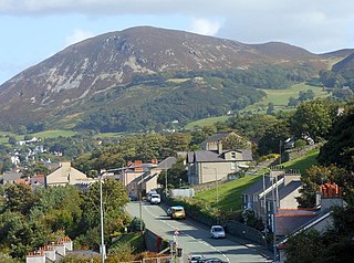
Penmaenmawr is a town and community in Conwy County Borough, Wales, which was formerly in the parish of Dwygyfylchi and the traditional county of Caernarfonshire. It is on the North Wales coast between Conwy and Llanfairfechan and was an important quarrying town, though quarrying is no longer a major employer. The population of the community was 4,353 in 2011, including Dwygyfylchi and Capelulo. The town itself having a population of 2,868 (2011).

<span class="mw-page-title-main">Llangammarch Wells</span> Human settlement in Wales

Llangammarch Wells or simply Llangammarch is a village in the community of Llangamarch in Powys, Wales, lying on the Afon Irfon, and in the historic county of Brecknockshire (Breconshire).

<span class="mw-page-title-main">Ystradfellte</span> Village in Powys, Wales

Ystradfellte is a village and community in Powys, Wales, about 6 miles (10 km) north of Hirwaun, with 556 inhabitants. It belongs to the historic county of Brecknockshire (Breconshire) and the Fforest Fawr area of the Brecon Beacons National Park, beside the Afon Mellte river. The village is linked by minor roads with Heol Senni to the north and the A4059 north of Penderyn, and with Pontneddfechan, which lies in the community, at the head of the Vale of Neath to the south.

<span class="mw-page-title-main">Pen y Fan</span> Welsh mountain peak of the Brecon Beacons, Powys

Pen y Fan is the highest peak in South Wales, situated in the Brecon Beacons National Park. At 886 metres (2,907 ft) above sea-level, it is also the highest British peak south of Cadair Idris in Snowdonia. It is the highest point of the historic county of Brecknockshire. The twin summits of Pen y Fan and Corn Du at 873 metres (2,864 ft) were formerly referred to as Cadair Arthur or 'Arthur's Seat'.

Thomas Henry "Harri" Jones was a Welsh poet and university lecturer in Britain and Australia. Born in Wales, he wrote in English.

<span class="mw-page-title-main">Partrishow</span>

Partrishow, also known as Patricio, Patrishow, or by its Welsh names Merthyr Isw and Llanisw, is a small village and historic parish in the county of Powys, close to its border with Monmouthshire. It is in the valley of the Grwyne Fawr, in the Black Mountains of South Wales, within the Brecon Beacons National Park.

<span class="mw-page-title-main">Saint Afan</span>

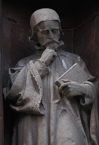
Saint Afan of Builth was an early 6th-century Welsh bishop, martyr, and saint. His feast day is generally placed on 17 November, although the Demetian Calendar formerly used in southern Wales placed it on the 16th; it is no longer observed by either the Anglican or Catholic church in Wales.

<span class="mw-page-title-main">Erwood</span>

Erwood is a village and community lying beside the River Wye, on the A470 road some 6 miles south-east of Builth Wells in Powys, Wales. The population of the community taken at the 2011 census was 429. It is in the historic county of Brecknockshire (Breconshire) and the older cantref of Cantref Selyf. The community includes the settlements of Crickadarn, Gwenddwr and Llaneglwys.

<span class="mw-page-title-main">Thomas Huet</span>

Thomas Huet was a Welsh clergyman and translator of the Bible.

Llantrisant is a hamlet in Anglesey, Wales. It is in the community of Tref Alaw.

Llan and its variants are a common element of Celtic placenames in the British Isles and Brittany, especially of Welsh toponymy. In Welsh the name of a local saint or a geomorphological description follows the Llan morpheme to form a single word: for example Llanfair is the parish or settlement around the church of St. Mair. Goidelic toponyms end in -lann.

<span class="mw-page-title-main">Llywel</span>

Llywel is a small village located on the A40, about 4 miles (6.4 km) west of Sennybridge in Brecknockshire, Wales. The Afon Gwydderig runs through the village, not far from its source. Llywel also gives its name to a community. The main settlement in the community is Trecastle. According to the 2001 Census the population of Llywel community is 524, falling to 497 at the 2011 Census.

<span class="mw-page-title-main">Llangenny</span>

Llangenny is a village in the Brecon Beacons National Park, Powys, Wales. It is in the lower reaches of the Grwyne Fawr. The Vale of Grwyney community consists of Glangrwyney, Llanbedr, and Llangenny.

<span class="mw-page-title-main">St Afan's Church, Llanafan</span> Church in Ceredigion, Wales

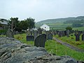
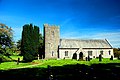
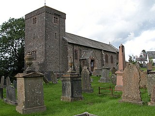
Saint Afan's Church (SN68387192) is located in Llanafan, 8 miles (13 km) east of Aberystwyth, Ceredigion, in Wales.

<span class="mw-page-title-main">Buellt</span> Medieval cantref of Wales

Buellt or Builth was a cantref in medieval Wales, located west of the River Wye. Unlike most cantrefs, it was not part of any of the major Welsh kingdoms for most of its history, but was instead ruled by an autonomous local dynasty. During the Norman era it was associated with Rhwng Gwy a Hafren, a region independent of the Welsh monarchies and controlled by Norman Marcher Lords. In the 16th century, it was reorganized as a hundred and joined with the former kingdom of Brycheiniog to form the county of Brecknockshire.

<span class="mw-page-title-main">Llanafan, Ceredigion</span>

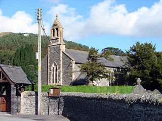
Llanafan is a small village between Tregaron and Aberystwyth, Ceredigion, in Wales. Llanafan is around ten miles from Aberystwyth and Tregaron. It is named for its parish church, St Afan's, which serves as the chapel for the nearby Trawsgoed Estate. Its eponymous saint supposedly founded the settlement in the 7th century. The village also has a hall and primary school founded in 1856 by Ernest Vaughan, 4th Earl of Lisburne, for which it was originally known as the Earl of Lisburne School.

<span class="mw-page-title-main">Duhonw</span>

Duhonw is a rural community in Powys, Wales, to the south of Builth Wells, in the historic county of Breconshire. Covering an area of 4,376 hectares (16.90 sq mi) and including scattered farms and dwellings, it is bounded to its north by the Afon Irfon, to its south by Mynydd Epynt and Banc y Celyn (472m) and to its east the rivers Duhonw and Wye. Llangammarch Wells' is to its west.

Llanafan may refer to any of:

<span class="mw-page-title-main">Llanfechan</span> Human settlement in Wales

Llanfechan is a small church settlement in the community of Treflys, consisting of a church and a farm, and the surrounding area, it is beside the A483 on the north side of the Irfon Valley near Cilmeri, about 7 kilometers (4.3 mi) west of Builth Wells, Powys, Wales.

References

  1. "Community population 2011" . Retrieved 11 November 2015.
  2. 1 2 Baring-Gould, Sabine & al. The Lives of the British Saints: The Saints of Wales and Cornwall and Such Irish Saints as Have Dedications in Britain, Vol. I, pp. 114 ff. Chas. Clark (London), 1908. Hosted at Archive.org. Accessed 18 Nov 2014.
  3. Lloyd, John Edward (1959). "AFAN". Dictionary of Welsh Biography . National Library of Wales . Retrieved 20 October 2021.
  4. Link to photo of Cwm Crogau.
  5. "Ward population 2011" . Retrieved 11 November 2015.
  6. 1 2 "Where Parched Pilgrims Rested" by David Williams, Western Mail, 24 April 2004
  7. Roberts, Brynley F. (2004). "Huet, Thomas (died 1591)". Oxford Dictionary of National Biography (online edition, subscription access). Oxford University Press . Retrieved 27 February 2008.
  8. 1 2 Castles in Wales. "Llanafan Fawr".
  9. 1 2 Gerald of Wales (1978). The Journey Through Wales and the Description of Wales. Penguin Classics. pp. 78–79. ISBN   0-14-044339-8.
  10. "At this point I must tell you what happened, in the reign of Henry I, King of the English, to the castellan of Radnor castle, in the territory of Builth, which is not far away, being adjacent to his own lands, which he himself conquered. He had gone into the church of Saint Afan, called Llanafan in Welsh, and there he had spent the night with his dogs, which was a foolish and irreverent thing to do. He got up at first light, as hunters are wont to do, but he found that all his dogs had gone mad and that he himself was blind. He had lost his sight completely and he had to grope his way out with his hand..." [9]
  11. "1932 - Davies family and Red Lion, Llanafan Fawr" at peoplescollectionwales.co.uk