
Until 1974, Brecknockshire, also formerly known as the County of Brecknock, Breconshire, or the County of Brecon, was an administrative county in the south of Wales, later classed as one of the thirteen historic counties of Wales. Named after its county town of Brecon, the county was mountainous and primarily rural.
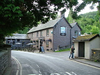
Talybont-on-Usk is a village and community in Powys, Wales, in the historic county of Brecknockshire. It lies on both the Caerfanell river and the Monmouthshire and Brecon Canal, about 1 mile (1.6 km) from the River Usk. In 2001, it had a population of 743, reducing to 719 at the 2011 census. The community includes the settlements of Llansantffraed, Scethrog, Aber Village, and Pencelli.
Berriew is a village and community in Montgomeryshire, Powys, Wales. It is on the Montgomeryshire Canal and the Afon Rhiw, near the confluence with the River Severn at grid reference SJ185005, 79 miles (128 km) from Cardiff and 151 miles (243 km) from London. The village itself had a population of 283. and the community also includes Garthmyl Hall and Refail.

Three Cocks or Aberllynfi is a village near Glasbury in Powys, Wales. The Welsh name refers to the mouth of the Afon Llynfi which enters the River Wye a mile from the village. The nearest town is Hay-on-Wye some 5 miles (8.5 km) to the northeast.

Mawr is a community of the City and County of Swansea, in south Wales, U.K. Mawr has its own elected community council. Its name simply means "large", and it was given the name because it was the largest piece of land in the former parish of Llangyfelach.

Llangyfelach is a village and community located in the City and County of Swansea, Wales, United Kingdom. Llangyfelach is situated about 4 miles north of the centre of Swansea, just west of Morriston. It falls within the Llangyfelach ward. To the west is open moorland. The population was 2,371 as of the 2021 UK census. The name is seemingly derived from a combination of 'llan' and 'Cyfelach', with a mutation to combine them for Llangyfelach.
Beguildy is a village and community in Powys, Wales.
Llyswen is a small village in Powys, Wales on the west bank of the River Wye. It was formerly within the county of Brecknockshire and now forms part of the Community of Bronllys. The nearest town is Brecon approximately 8 miles (13 km) to the south-west.
Trewern is a small village, community and electoral ward in Montgomeryshire, Powys, Wales. The community includes the villages of Buttington and Middletown, situated 4.5 miles (7.2 km) northeast of Welshpool, 14.5 miles (23.3 km) west of Shrewsbury and 1 mile (1.6 km) west of the Wales-England border.
Glasbury, also known as Glasbury-on-Wye, is a village and community in Powys, Wales. The village lies at an important crossing point on the River Wye, connecting the historic counties of Brecknockshire and Radnorshire, and is located just outside the Brecon Beacons National Park, north of the Black Mountains. The village is split between the communities of Glasbury and Gwernyfed. The nearest town is Hay-on-Wye, some 4 miles (6 km) to the north east. The nearest city is Hereford in England, some 25 miles (40 km) to the east. Glasbury is a popular location for river fishing, canoeing and kayaking. The population of Glasbury community in Radnorshire was 994, in 1841 it was 838.

Gwernyfed High School is a old manor house turned into a high school in the village of Three Cocks, Brecon, Powys, Wales. The school is an English-medium school educating students between 11 and 19 years old from a mainly rural catchment area.
Pipton is a small settlement and former civil parish in Powys, Wales on the Afon Llynfi near its confluence with the River Wye. It was formerly in the county of Brecknockshire and is now part of the community of Bronllys. The nearest town is Hay-on-Wye some 5 miles (8.0 km) to the east.

William "Bill" Powell is a Welsh Liberal Democrat politician. He has been a Powys County Councillor since 2004, and was a member of the Member of the Welsh Assembly (AM) for the Mid and West Wales Region from 2011 to 2016.
Llanelieu is a small settlement and former civil parish (community) in Powys, Wales on the northern edge of the Black Mountains within the Brecon Beacons National Park. It lies within the historic bounds of Brecknockshire. The settlement is now part of the community of Talgarth. The nearest town is Talgarth some 2.5 miles (4.0 km) to the west.

Disserth and Trecoed is an electoral ward and community in central Powys, Wales. It has a population of 1,239 according to the 2011 UK census.

Mochdre is a small village in the community of Mochdre with Penstrowed, in Montgomeryshire, Powys, Wales.

Newtown and Llanllwchaiarn is a local government community in mid Powys, Wales. It includes the town of Newtown and the small neighbouring village of Llanllwchaiarn. At the time of the 2011 census the population of the community was 11,357. The community council is called Newtown and Llanllwchaiarn Town Council, often abbreviated to Newtown Town Council.

James Evans is a Welsh Conservative Party politician, who has served as the Member of the Senedd (MS) for Brecon and Radnorshire since the 2021 Senedd election.

Old Gwernyfed is a house dating from the medieval period in the community of Gwernyfed, Powys, Wales, close to the village of Felindre. It remains a private home and is a Grade I listed building. The gardens are listed on the Cadw/ICOMOS Register of Parks and Gardens of Special Historic Interest in Wales.


