
The A44 is a major road in the United Kingdom that runs from Oxford in southern England to Aberystwyth in west Wales.

Radnorshire is one of the thirteen historic counties of Wales and a former administrative county. It covers a sparsely populated area in mid Wales. The historic county was bounded to the north by Montgomeryshire and Shropshire, to the east by Herefordshire, to the south by Brecknockshire and to the west by Cardiganshire.
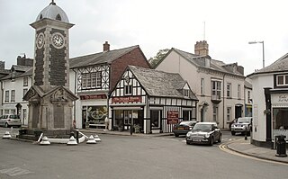
Rhayader is a market town and community in Powys, Wales, within the historic county of Radnorshire. The town is 20 miles (32 km) from the source of the River Wye on Plynlimon, the highest point of the Cambrian Mountains, and is located at the junction of the A470 road and the A44 road 13 miles (21 km) north of Builth Wells and 30 miles (48 km) east of Aberystwyth.

Llanelwedd[ɬanˈɛlwɛð] is a village and community near Builth Wells, in Powys, Wales. It lies within the historic boundaries of Radnorshire. Llanelwedd features the Royal Welsh Showground.
Berriew is a village and community in Montgomeryshire, Powys, Wales. It is on the Montgomeryshire Canal and the Afon Rhiw, near the confluence with the River Severn at grid reference SJ185005, 79 miles (128 km) from Cardiff and 151 miles (243 km) from London. The village itself had a population of 283. and the community also includes Garthmyl Hall and Refail.
Penybont is a small village in Radnorshire, Powys, Wales. The population of the community at the 2011 census was 428. The community includes the settlement of Llandegley.

The District of Radnorshire was one of three local government districts of the county of Powys, Wales, from 1974 until 1996. The district had an identical area to the previous administrative county of Radnorshire. The district was abolished in 1996, with Powys County Council taking over its functions.

Llanbadarn Fawr is a village and community in Ceredigion, Wales. It is on the outskirts of Aberystwyth next to Penparcau and Southgate. It forms the eastern part of the continually built-up area of Aberystwyth. It holds two electoral wards, Padarn and Sulien which elect a Ceredigion County Councillor each and several Llanbadarn Fawr Community Councillors. At the 2001 census its population as a community was recorded at 2,899, increasing to 3,380 at the 2011 census.
Llanyre is a village and electoral ward in Radnorshire, Powys, Wales. The community had a population of 1,061 in 2001, increasing to 1,141 at the 2011 Census. It includes the village of Newbridge-on-Wye.
Crossgates is a village in Powys, mid Wales, in the historic county of Radnorshire. It is the main settlement of the community of Llanbadarn Fawr, which had a population of 701 in 2011. Crossgates is located three miles northeast of Llandrindod Wells and eight miles southeast of Rhayader, at the point where the A483 and A44 roads intersect. It is notable as the site of a busy service station, and for lending its name to Crossgates Coaches. The population in 2011 was 327 with 47% born in Wales and 48% in England.
The Mid Wales South League is an association football league, currently consisting of five clubs, mainly from Mid Wales but some from just over the border in England. It is currently called the Watson Financial Mid Wales League (South) for sponsorship reasons.
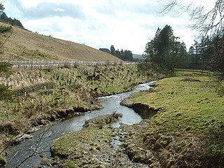
The River Ithon is a major left-bank tributary of the River Wye in Powys, mid Wales. It rises in the broad saddle between the western end of Kerry Hill and the hill of Glog to its west and flows initially southwards to Llanbadarn Fynydd. It then takes a twisting route south via the villages of Llanbister, Llanddewi Ystradenny and Penybont before turning southwest, then doubling back northwards towards Crossgates. From here it resumes a southwesterly course, flowing past Llandrindod Wells and the site of Cefnllys Castle to a confluence with the Wye, 1 mile to the south of Newbridge-on-Wye.

Fron is a small village in Powys, Wales, within the community of Llanbadarn Fawr. Fron lies northeast of Llandrindod Wells and east of Clywedog Brook, which flows into the River Ithon.
Llanbister is a small village and community with a 2011 population of 382 in Powys, mid Wales, in the historic county of Radnorshire.
Stephen W Williams or Stephen Williams (1837–1899) was a civil engineer and architect who worked mainly in Radnorshire and Breconshire, Wales. He was county surveyor of Radnorshire from 1864 to 1899. He had offices at Rhayader and lived at Penralley House, Rhayader, He became a noted authority on the archaeology of the Cistercian Monasteries in Wales and undertook excavations at Strata Florida Abbey in Ceredigion, Abbey Cwm Hir in Radnorshire and Strata Marcella near Welshpool in Montgomeryshire. He was appointed High Sheriff of Radnorshire in 1899.
Llanbadarn Fynydd is a village and community in Radnorshire, Powys, Wales, and is 63 miles (101 km) from Cardiff and 149 miles (240 km) from London.

Nantmel is a village and a community in Radnorshire, Powys, Wales, and is 76.5 miles (123.1 km) from Cardiff and 150.5 miles (242.2 km) from London. In 2011 the population of Nantmel was 621 with 11.8% of them able to speak Welsh. The population of the community was 637 as of the 2011 UK Census.

Llangunllo with Norton formerly known as Llangunllo, is the name of an electoral wards in central Powys, Wales. It covers the community of Llangunllo as well as the neighbouring communities of Llanfihangel Rhydithon and Whitton with the village of Norton. The ward elects a county councillor to Powys County Council.
The Radnorshire Challenge Cup is a football knockout tournament competed for by clubs either based within the Mid-Wales county boundary of Radnorshire or have a team in membership of the Mid Wales South League.


