
The River Usk rises on the northern slopes of the Black Mountain, Wales, in the westernmost part of the Brecon Beacons National Park. Initially forming the boundary between Carmarthenshire and Powys, it flows north into Usk Reservoir, then east by Sennybridge to Brecon before turning southeast to flow by Talybont-on-Usk, Crickhowell and Abergavenny after which it takes a more southerly course.

Crickhowell is a town and community in southeastern Powys, Wales, near Abergavenny, and is in the historic county of Brecknockshire.

The Black Mountains are a group of hills spread across parts of Powys and Monmouthshire in southeast Wales, and extending across the England–Wales border into Herefordshire. They are the easternmost of the four ranges of hills that comprise the Brecon Beacons National Park, and are frequently confused with the westernmost, which is known as the Black Mountain. The Black Mountains may be roughly defined as those hills contained within a triangle defined by the towns of Abergavenny in the southeast, Hay-on-Wye in the north and the village of Llangors in the west. Other gateway towns to the Black Mountains include Talgarth and Crickhowell. The range of hills is well known to walkers and ramblers for the ease of access and views from the many ridge trails, such as that on the Black Hill (Herefordshire) at the eastern edge of the massif. The range includes the highest public road in Wales at Gospel Pass, and the highest point in southern England at Black Mountain.
Talybont-on-Usk is a village and community in Powys, Wales, in the historic county of Brecknockshire. It lies on both the Caerfanell river and the Monmouthshire and Brecon Canal, about 1 mile (1.6 km) from the River Usk. In 2001, it had a population of 743, reducing to 719 at the 2011 census. The community includes the settlements of Llansantffraed, Scethrog, Aber Village, and Pencelli.

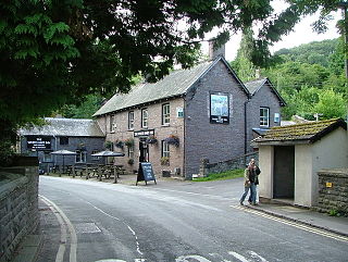
Llangynidr is a village, community and electoral ward in Powys, Wales, about 4 miles (6.4 km) west of Crickhowell and 9 miles (14.5 km) south-east of Brecon. The River Usk flows through the village as does the Monmouthshire and Brecon Canal. It is in the historic county of Brecknockshire.

The Grwyne Fawr is a river in the Brecon Beacons National Park in south Wales. A section of it forms the administrative border between Powys and Monmouthshire and also of the historic counties of Brecon and Monmouth. The river and its major tributary the Grwyne Fechan flow into the River Usk at Glangrwyney.

Llangenny is a village in the Brecon Beacons National Park, Powys, Wales. It is in the lower reaches of the Grwyne Fawr. The Vale of Grwyney community consists of Glangrwyney, Llanbedr, and Llangenny.

Llanbedr is a small village 2 miles (3 km) northeast of Crickhowell in the county of Powys, Wales and the community of Vale of Grwyney. It lies above the river known as the Grwyne Fechan just above its confluence with the Grwyne Fawr in the southern reaches of the Black Mountains range. The village lies within the shadow of Table Mountain, an outlying spur of Pen Cerrig-calch on which is perched the Iron Age hill fort of Crug Hywel.
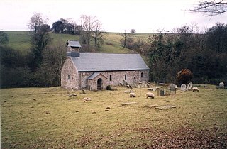
Llanelieu is a small settlement and former civil parish (community) in Powys, Wales on the northern edge of the Black Mountains within the Brecon Beacons National Park. It lies within the historic bounds of Brecknockshire. The settlement is now part of the community of Talgarth. The nearest town is Talgarth some 2.5 miles (4.0 km) to the west.

Bausley with Criggion is a community in Montgomeryshire, Powys, Wales, 87 miles (140 km) from Cardiff and 148 miles (238 km) from London.

Carreghofa is a community in Montgomeryshire, Powys, Wales, and is 89.6 miles (144.2 km) from Cardiff and 153.6 miles (247.2 km) from London. In 2011 the population of Carreghofa was 667 with 10.2% of them able to speak Welsh. 78% of people had no form of Welsh identity.

Glyn Tarell is a valley and a community in the county of Powys, Wales, and the historic county of Brecknockshire. It is in the Brecon Beacons National Park and at the northern edge of the Brecon Beacons mountains.

Lampeter Velfrey is a community and parish in the county of Pembrokeshire, Wales, which lies 68.0 miles (109.4 km) from Cardiff and 196.0 miles (315.4 km) from London. In 2011 the population of the parish was 1,205, with 20.2 per cent of them able to speak Welsh. Besides Lampeter Velfrey village, other settlements in the community include Princes Gate, Ludchurch, Llan-mill, Melinau and Tavernspite.

Llanfihangel Rhydithon is a community in the county of Powys, (Radnorshire) Wales, and is 56.1 miles (90.3 km) from Cardiff and 143.5 miles (231.0 km) from London. In 2011 the population of Llanfihangel Rhydithon was 228 with 6.7% of them able to speak Welsh.

Maescar is a community in the county of Powys, Wales, and is 35.4 miles (56.9 km) from Cardiff and 148.7 miles (239.3 km) from London. It is in the historic county of Brecknockshire.
Manafon is a small rural community located in the hills of Montgomeryshire, the Northern part of the Welsh county of Powys. The Parish focuses on the valley of the River Rhiew that runs west to east into the River Severn". The community of Manafon consists of "two main villages within about a mile of one another, Manafon and New Mills. The remainder of the population lives in scattered farms and dwellings and in the small rural settlement of The Green."

Nantmel is a village and a community in Radnorshire, Powys, Wales, and is 76.5 miles (123.1 km) from Cardiff and 150.5 miles (242.2 km) from London. In 2011 the population of Nantmel was 621 with 11.8% of them able to speak Welsh. The population of the community was 637 as of the 2011 UK Census.
Treflys is a community in the county of Powys, Wales, and is 49.9 miles (80.4 km) from Cardiff and 154.4 miles (248.5 km) from London. In 2011 the population of Treflys was 484 with 15.1% of them able to speak Welsh. It is in the historic county of Brecknockshire.

Yscir is a community in the county of Powys, Wales and is 35.3 miles (56.7 km) from Cardiff.
Glangrwyney or Glangrwyne is a village 2 miles (3.2 km) southeast of Crickhowell in Powys, Wales. The village is where the Grwyne Fawr has its confluence with the River Usk, southeast of the Sugar Loaf and at the junction of the road from Gilwern with the A40 trunk road. Glangrwyney is in the Vale of Grwyney Community for administrative purposes. The village is built upon the sands and gravels of a dissected alluvial fan which extends into the floodplain of the Usk, together with till derived from the former Usk Valley glacier.


