Lonaconing, Maryland

Last updated

Lonaconing
2016-06-18 15 25 01 View north along Maryland State Route 36 (Main Street) at Douglas Avenue in Lonaconing, Allegany County, Maryland.jpg
Central Lonaconing along MD 36
Seal of Lonaconing, Maryland.png
Allegany County Maryland Incorporated and Unincorporated areas Lonaconing Highlighted.svg
Location of Lonaconing, Maryland
USA Maryland location map.svg
Red pog.svg
Lonaconing
Usa edcp location map.svg
Red pog.svg
Lonaconing
Coordinates: 39°33′57″N78°58′44″W / 39.56583°N 78.97889°W / 39.56583; -78.97889
Country Flag of the United States.svg United States
State Flag of Maryland.svg  Maryland
County Flag of Allegany County, Maryland.png Allegany
Incorporated 1890 [1]
Area
[2]
  Total0.36 sq mi (0.94 km2)
  Land0.36 sq mi (0.94 km2)
  Water0.00 sq mi (0.00 km2)
Elevation
[3]
1,499 ft (457 m)
Population
 (2020)
  Total1,001
  Density2,765.19/sq mi (1,067.89/km2)
Time zone UTC-5 (Eastern (EST))
  Summer (DST) UTC-4 (EDT)
ZIP code
21539
Area code(s) 301, 240
FIPS code 24-47875
GNIS feature ID2391273 [3]

Lonaconing is a town in Allegany County, Maryland, United States, located along the Georges Creek Valley. It is part of the Cumberland, MD-WV Metropolitan Statistical Area. The population was 1,214 at the 2010 census.

Contents

History

The first non-Native American settlers in the late 18th century were explorers, hunters and farmers. Surnames of some of the first settlers were Dye, Duckworth, Green, Grindle, Fazenbaker, Grove, VanBuskirk, Knapp, and Miller. The first stone house, built in 1790, in Knapps Meadow, just north of Lonaconing, was owned by Samuel VanBuskirk. The house still stands and is a private residence as of 2016. The Lonaconing Historic District was listed on the National Register of Historic Places in 1983. [4]

Lonaconing is the birthplace of Baseball Hall of Fame pitcher Robert Moses ("Lefty") Grove, (1900-1975), who played notably for the old Baltimore Orioles, 1920–1925, during their famous string of six straight championships in the "Triple A" (AAA) minor league level of the International League, and later for Connie Mack's Philadelphia Athletics, (1925-1933) and the Boston Red Sox, 1934–1941, of the American League. Grove's "Most Valuable Player" Award is the only one not on display at the National Baseball Hall of Fame in Cooperstown, New York, as it is displayed at the George's Creek Library of the Western Maryland Regional Library system.

On January 20, 2021, the fourth largest Powerball and sixth largest lottery jackpot ticket in U.S. history was sold at Coney Market, a convenience store in Lonaconing, to an anonymous winner. [5]

Lonaconing glassware manufacturers

Early mining railroads

Iron and coal companies in Lonaconing built railroads in the 1840s, in anticipation of connecting with the Baltimore and Ohio Railroad (B&O) and the Chesapeake and Ohio Canal. Some of these mining companies owned and operated their own railroad equipment. The Georges Creek Rail Road was built south from Lonaconing to connect with the Baltimore & Ohio at Piedmont(WV) [6] All of the rail lines were absorbed into the Cumberland and Pennsylvania Railroad (C&P) by 1870. [7]

The Lonaconing Furnace (1836–1855)

The Georges Creek Coal and Iron Company constructed and operated a blast furnace [8] in Lonaconing from 1836 to 1855 along with constructing and operating the related Georges Creek Railroad from 1851 to 1863. The Lonaconing Furnace was listed on the National Register of Historic Places in 1973. [4]

Demographics

Historical population
CensusPop.Note
1900 2,181
1910 1,553−28.8%
1920 2,05432.3%
1930 2,42618.1%
1940 2,4290.1%
1950 2,289−5.8%
1960 2,007−12.3%
1970 1,572−21.7%
1980 1,420−9.7%
1990 1,122−21.0%
2000 1,2057.4%
2010 1,2140.7%
2020 1,001−17.5%
U.S. Decennial Census [9]

2010 census

As of the census [10] of 2010, there were 1,214 people, 463 households, and 303 families living in the town. The population density was 2,961.0 inhabitants per square mile (1,143.2/km2). There were 525 housing units at an average density of 1,280.5 per square mile (494.4/km2). The racial makeup of the town was 98.1% White, 0.3% African American, 0.2% Asian, and 1.4% from two or more races. Hispanic or Latino of any race were 0.5% of the population.

There were 463 households, of which 30.9% had children under the age of 18 living with them, 47.3% were married couples living together, 13.4% had a female householder with no husband present, 4.8% had a male householder with no wife present, and 34.6% were non-families. 31.1% of all households were made up of individuals, and 15.6% had someone living alone who was 65 years of age or older. The average household size was 2.48 and the average family size was 3.08.

The median age in the town was 40.5 years. 23.8% of residents were under the age of 18; 8.3% were between the ages of 18 and 24; 24.3% were from 25 to 44; 22.9% were from 45 to 64; and 20.5% were 65 years of age or older. The gender makeup of the town was 47.2% male and 52.8% female.

2000 census

As of the census [11] of 2000, there were 1,205 people, 482 households, and 290 families living in the town. The population density was 2,875.8 inhabitants per square mile (1,110.4/km2). There were 559 housing units at an average density of 1,334.1 per square mile (515.1/km2). The racial makeup of the town was 98.67% White, 0.66% African American, 0.08% Pacific Islander, 0.08% from other races, and 0.50% from two or more races. Hispanic or Latino of any race were 0.50% of the population. At 16.1 percent Scottish, Lonaconing is the most Scottish town in the United States.

There were 482 households, out of which 28.0% had children under the age of 18 living with them, 46.9% were married couples living together, 10.0% had a female householder with no husband present, and 39.8% were non-families. 36.1% of all households were made up of individuals, and 21.8% had someone living alone who was 65 years of age or older. The average household size was 2.37 and the average family size was 3.15.

In the town, the population was spread out, with 23.9% under the age of 18, 8.1% from 18 to 24, 25.9% from 25 to 44, 19.5% from 45 to 64, and 22.6% who were 65 years of age or older. The median age was 38 years. For every 100 females, there were 83.7 males. For every 100 females age 18 and over, there were 75.0 males.

The median income for a household in the town was $27,434, and the median income for a family was $37,083. Males had a median income of $27,315 versus $19,423 for females. The per capita income for the town was $13,890. About 12.8% of families and 19.6% of the population were below the poverty line, including 30.3% of those under age 18 and 17.7% of those age 65 or over.

Geography

According to the United States Census Bureau, the town has a total area of 0.41 square miles (1.06 km2), all land. [12]

Schools

Westmar Middle School was opened in the fall of 2007 when it was relocated to Lonaconing after the closure of the Westmar Middle School facility in Westernport. Prior to the fall of 2007, the building was occupied by Westmar High School, originally Valley High School, which was established in 1953 and renamed "Westmar" during the 1989–1990 school year, three years after the consolidation of Bruce High School in 1986. Westmar High School closed, vacating the building for future use a middle school, following the 2006–2007 school year after which the populations of Westmar and Beall High schools consolidated into the newly built Mountain Ridge High School in Frostburg.

Georges Creek Elementary was opened in 1975 with the closing of Central School. It combined populations with Barton Elementary in 2000. The school has approximately 380 students.

Transportation

MD 36 southbound in Lonaconing 2019-05-17 15 39 50 View south along Maryland State Route 36 (Main Street) at Union Street in Lonaconing, Allegany County, Maryland.jpg
MD 36 southbound in Lonaconing

The main method of travel to and from Lonaconing is by road. The only significant highway serving the town is Maryland Route 36, which also serves as Main Street. MD 36 heads northward towards Frostburg and Interstate 68, while to the south, it terminates at the town of Westernport.

Notable person

See also

Related Research Articles

<span class="mw-page-title-main">Allegany County, Maryland</span> County in Maryland, United States

Allegany County is located in the northwestern part of the U.S. state of Maryland. As of the 2020 census, the population was 68,106. Its county seat is Cumberland. The name Allegany may come from a local Lenape word, welhik hane or oolikhanna, which means 'best flowing river of the hills' or 'beautiful stream'. A number of counties and a river in the Appalachian region of the U.S. are named Allegany, Allegheny, or Alleghany. Allegany County is part of the Cumberland metropolitan area. It is a part of the Western Maryland "panhandle".

<span class="mw-page-title-main">Sandborn, Indiana</span> Town in Indiana, United States

Sandborn is a town in Vigo Township, Knox County, Indiana, United States. The population was 359 at the 2020 census. It is the home of the annual Black Creek Festival.

<span class="mw-page-title-main">Battle Creek, Iowa</span> City in Iowa, United States

Battle Creek is a city in Ida County, Iowa, United States. The population was 700 at the 2020 census.

<span class="mw-page-title-main">Ida Grove, Iowa</span> City in Iowa, United States

Ida Grove is a city in Ida County, Iowa, United States. The population was 2,051 at the time of the 2020 census. It is the county seat of Ida County.

<span class="mw-page-title-main">Silver City, Iowa</span> City in Iowa, United States

Silver City is a city in Mills County, Iowa, United States. The population was 245 at the 2020 census. The Wabash Trace—a railroad converted to a bicycle trail—passes through here. At trailside, there is a small park with a gazebo, and across from it, a small cafe.

<span class="mw-page-title-main">Woolstock, Iowa</span> City in Iowa, United States

Woolstock is a city in Wright County, Iowa, United States. The population was 144 at the time of the 2020 census.

<span class="mw-page-title-main">Barton, Maryland</span> Town in Maryland, United States

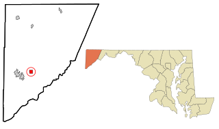
Barton is a town in Allegany County, Maryland, United States, located along the Georges Creek Valley. It is part of the Cumberland, MD-WV Metropolitan Statistical Area. The population was 457 at the 2010 census.

<span class="mw-page-title-main">Midland, Maryland</span> Town in Maryland, United States

Midland is a town in Allegany County, Maryland, United States, along the Georges Creek Valley. It is part of the Cumberland, MD-WV Metropolitan Statistical Area. The population was 446 at the 2010 census. Midland was founded in 1850 as a coal-mining community, though today only some strip mining remains.

<span class="mw-page-title-main">Westernport, Maryland</span> Town in Maryland, United States

Westernport is a town in Allegany County, Maryland, United States, along the Georges Creek Valley. It is part of the Cumberland, MD-WV Metropolitan Statistical Area. The population was 1,888 at the 2010 census.

<span class="mw-page-title-main">Deer Park, Maryland</span> Town in Maryland, United States

Deer Park is a town in Garrett County, Maryland, United States. The population was 399 at the 2010 census. It is part of the Pittsburgh Media Market.

<span class="mw-page-title-main">Cambridge, Nebraska</span> City in Nebraska, United States

Cambridge is a city in Furnas County, Nebraska, United States. The population was 1,063 at the 2010 census.

<span class="mw-page-title-main">Roland, Oklahoma</span> Town in Oklahoma, United States

Roland is a town in Sequoyah County, Oklahoma, United States. It is part of the Fort Smith, Arkansas-Oklahoma Metropolitan Statistical Area. The population was 3,169 at the 2010 census, compared to the figure of 2,842 recorded in 2000.

<span class="mw-page-title-main">Lower Chanceford Township, Pennsylvania</span> Township in Pennsylvania, United States

Lower Chanceford Township is a township in York County, Pennsylvania, United States. The population was 3,028 at the 2020 census.

<span class="mw-page-title-main">Lowry, South Dakota</span> Town in South Dakota, United States

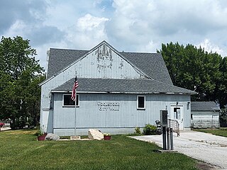
Lowry is a town in Walworth County, South Dakota, United States. The population was 10 at the 2020 census. The town is home to Lowry Pilgrim Community Church, Swan Creek Harness Shop, J & C Repair, Karst Service and a fire station. Lowry also has an abandoned school, and a post office, which closed to service in the early 1970s.

<span class="mw-page-title-main">Lost Creek, West Virginia</span> Town in West Virginia, United States

Lost Creek is a town in Harrison County, West Virginia, United States. The population was 359 at the 2020 census.

<span class="mw-page-title-main">Piedmont, West Virginia</span> Town in West Virginia, United States

Piedmont is a town in Mineral County, West Virginia, United States. It is part of the Cumberland, MD-WV metropolitan statistical area. The population was 716 at the 2020 census. Piedmont was chartered in 1856 and the town is the subject of Colored People: A Memoir by Piedmont native Henry Louis Gates Jr.

<span class="mw-page-title-main">Queen Anne, Maryland</span> Town in Maryland, United States of America

Queen Anne is a town in Queen Anne's and Talbot counties in the U.S. state of Maryland. The population was 222 at the 2010 census.

<span class="mw-page-title-main">Dearborn, Missouri</span> City in Missouri, United States

Dearborn is a city in Buchanan and Platte counties in the U.S. state of Missouri and is part of the Kansas City metropolitan area. The population was 482 at the 2020 census.

<span class="mw-page-title-main">Maryland Route 36</span> State highway in Allegany County, Maryland, US

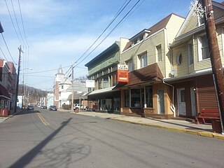
Maryland Route 36 is a 29.43-mile (47.36 km) state highway located in Allegany County, Maryland, United States. MD 36's southern terminus is at the West Virginia Route 46 (WV 46) bridge in Westernport and its northern terminus at U.S. Route 40 Alternate near Cumberland. Between Westernport and Frostburg, it is known as Georges Creek Road, and from Frostburg to Cumberland it is known as Mount Savage Road. Like the majority of Maryland state highways, MD 36 is maintained by the Maryland State Highway Administration (MDSHA).

Mountain Ridge High School is a high school in Frostburg, Maryland, United States, that houses over 1000 students from the Georges Creek Valley, the Greater Frostburg vicinity, and the Westernport region. Mountain Ridge is part of Allegany County Public Schools. The school mascot is a miner and the school colors are red, black, white and gold.

References

  1. "Lonaconing". Maryland Manual. Retrieved June 25, 2017.
  2. "2020 U.S. Gazetteer Files". United States Census Bureau. Retrieved April 26, 2022.
  3. 1 2 U.S. Geological Survey Geographic Names Information System: Lonaconing, Maryland
  4. 1 2 "National Register Information System". National Register of Historic Places . National Park Service. April 15, 2008.
  5. Diaz, Johnny (January 21, 2021). "Who Won the $731 Million Powerball?". The New York Times. ISSN   0362-4331 . Retrieved January 23, 2021.
  6. Stakem, Patrick H. Lonaconing Residency Iron Technology & the Railroad, 2010, PRB Publishing, ASIN: B004L62DNQ
  7. Patrick H. Stakem (2002). "Cumberland & Pennsylvania Railroad Revisited." p. 11. (Laurel, MD: Pat Stakem, 2002.) ISBN   0-9725966-0-7.
  8. The Lonaconing journals: The founding of a coal and iron community, 1837-1840 (Transactions of the American Philosophical Society; 1977, v. 67, pt. 2) ISBN   0-87169-672-X
  9. "Census of Population and Housing". Census.gov. Retrieved June 4, 2015.
  10. "U.S. Census website". United States Census Bureau . Retrieved January 25, 2013.
  11. "U.S. Census website". United States Census Bureau . Retrieved January 31, 2008.
  12. "US Gazetteer files 2010". United States Census Bureau. Archived from the original on July 2, 2012. Retrieved January 25, 2013.