Westernport, Maryland

Last updated

Westernport
Westernport, MD downtown.JPG
Downtown looking east on Church St in January 2014
Flag of Westernport, Maryland.png
Seal of Westernport, Maryland.svg
Allegany County Maryland Incorporated and Unincorporated areas Westernport Highlighted.svg
Location of Westernport, Maryland
USA Maryland location map.svg
Red pog.svg
Westernport
Usa edcp location map.svg
Red pog.svg
Westernport
Coordinates: 39°29′17″N79°02′34″W / 39.48806°N 79.04278°W / 39.48806; -79.04278
Country Flag of the United States.svg United States
State Flag of Maryland.svg  Maryland
County Flag of Allegany County, Maryland.png Allegany
Settled1758
Incorporated1859
Area
[1]
  Total0.91 sq mi (2.35 km2)
  Land0.88 sq mi (2.28 km2)
  Water0.03 sq mi (0.07 km2)
Elevation
[2]
971 ft (296 m)
Population
 (2020)
  Total1,812
  Density2,061.43/sq mi (796.23/km2)
Time zone UTC-5 (Eastern (EST))
  Summer (DST) UTC-4 (EDT)
ZIP codes
21562
Area code(s) 301, 240
FIPS code 24-82750
GNIS feature ID2391482 [2]
Website https://townofwesternport.com/?fs=e&s=cl

Westernport is a town in Allegany County, Maryland, United States, along the Georges Creek Valley. It is part of the Cumberland, MD-WV Metropolitan Statistical Area. The population was 1,888 at the 2010 census.

Contents

History

St. Peter Catholic Church on Church St in January 2014 St Peter church Westernport, MD.jpg
St. Peter Catholic Church on Church St in January 2014

Westernport's first settlement is identified on a French military map dating from 1758. The map is currently on display at École Militaire in Paris. The settlement at that time had no name. By 1774, it was known as Hardscrabble because the rocky soil made planting difficult. Some time in the mid-1790s, the name was changed to Westernport, with the town being the westernmost navigable port on the Potomac River. In the late 18th century and early to mid part of the 19th century, coal and timber was loaded onto flatboats where George's Creek empties into the Potomac, then floated down to near Great Falls, Virginia, where the goods were unloaded, the boats broken up to sell as lumber, with the operators walking back to Westernport. The town was incorporated in 1859.

In 1886–87 the Piedmont and Cumberland Railway was built through Westernport, connecting the town to Cumberland. [3]

Notable people

Geography

According to the United States Census Bureau, the town has a total area of 0.89 square miles (2.31 km2), of which 0.87 square miles (2.25 km2) is land and 0.02 square miles (0.05 km2) is water. [4]

Nearby communities

Climate

The climate in this area has mild differences between highs and lows, and there is adequate rainfall year-round. According to the Köppen Climate Classification system, Westernport has a marine west coast climate, abbreviated "Cfb" on climate maps. [5]

Transportation

The junction of MD 36 and MD 135 in Westernport 2019-05-17 16 05 54 View east along Maryland State Route 135 (Church Street-Front Street) at Maryland State Route 36 (New Georges Creek Road) in Westernport, Allegany County, Maryland.jpg
The junction of MD 36 and MD 135 in Westernport

The primary means of travel to and from Westernport are by road. The main highways serving the town are Maryland Route 36 and Maryland Route 135. To the south, MD 36 connects the town to West Virginia Route 46 on the other side of the North Branch Potomac River in Piedmont, while heading north, MD 36 passes Interstate 68 on its way to Frostburg. MD 135 connects eastward to U.S. Route 220 just north of Keyser. To the west, MD 135 eventually reaches U.S. Route 219 in Oakland. Within the town limits, Maryland Route 937 also serves locals, having formerly been the alignment of MD 36.

Demographics

Historical population
CensusPop.Note
1880 1,468
1890 1,5264.0%
1900 1,99830.9%
1910 2,70235.2%
1920 3,97747.2%
1930 3,440−13.5%
1940 3,5653.6%
1950 3,431−3.8%
1960 3,5593.7%
1970 3,106−12.7%
1980 2,706−12.9%
1990 2,454−9.3%
2000 2,104−14.3%
2010 1,888−10.3%
2020 1,812−4.0%
U.S. Decennial Census [6]

2010 census

As of the census [7] of 2010, there were 1,888 people, 810 households, and 532 families living in the town. The population density was 2,170.1 inhabitants per square mile (837.9/km2). There were 1,006 housing units at an average density of 1,156.3 per square mile (446.4/km2). The racial makeup of the town was 98.6% White, 0.5% African American, 0.1% Asian, and 0.7% from two or more races. Hispanic or Latino of any race were 0.4% of the population.

There were 810 households, of which 27.0% had children under the age of 18 living with them, 50.0% were married couples living together, 9.9% had a female householder with no husband present, 5.8% had a male householder with no wife present, and 34.3% were non-families. 31.5% of all households were made up of individuals, and 16.6% had someone living alone who was 65 years of age or older. The average household size was 2.33 and the average family size was 2.88.

The median age in the town was 44 years. 20.4% of residents were under the age of 18; 9% were between the ages of 18 and 24; 21.8% were from 25 to 44; 27.6% were from 45 to 64; and 21.2% were 65 years of age or older. The gender makeup of the town was 48.7% male and 51.3% female.

2000 census

American Legion building in downtown in January 2014 Westernport, MD american legion building.JPG
American Legion building in downtown in January 2014

As of the census [8] of 2000, there were 2,104 people, 909 households, and 601 families living in the town. The population density was 2,385.6 inhabitants per square mile (921.1/km2). There were 1,056 housing units at an average density of 1,197.3 per square mile (462.3/km2). The racial makeup of the town was 99.24% White, 0.19% African American, 0.10% Native American, 0.14% Asian, and 0.33% from two or more races. Hispanic or Latino of any race were 0.29% of the population.

There were 909 households, out of which 27.8% had children under the age of 18 living with them, 50.2% were married couples living together, 11.9% had a female householder with no husband present, and 33.8% were non-families. 31.7% of all households were made up of individuals, and 20.9% had someone living alone who was 65 years of age or older. The average household size was 2.31 and the average family size was 2.88.

The age distribution is 22.6% under the age of 18, 8.0% from 18 to 24, 25.9% from 25 to 44, 20.7% from 45 to 64, and 22.8% who were 65 years of age or older. The median age was 41 years. For every 100 females, there were 91.6 males. For every 100 females age 18 and over, there were 86.1 males.

The median income for a household in the town was $23,681, and the median income for a family was $31,714. Males had a median income of $34,896 versus $16,920 for females. The per capita income for the town was $12,503. About 12.1% of families and 16.5% of the population were below the poverty line, including 18.9% of those under age 18 and 14.2% of those age 65 or over.

Related Research Articles

<span class="mw-page-title-main">Allegany County, Maryland</span> County in Maryland, United States

Allegany County is located in the northwestern part of the U.S. state of Maryland. As of the 2020 census, the population was 68,106. Its county seat is Cumberland. The name Allegany may come from a local Lenape word, welhik hane or oolikhanna, which means 'best flowing river of the hills' or 'beautiful stream'. A number of counties and a river in the Appalachian region of the U.S. are named Allegany, Allegheny, or Alleghany. Allegany County is part of the Cumberland metropolitan area. It is a part of the Western Maryland "panhandle".

<span class="mw-page-title-main">Oakland, Maryland</span> Town in Maryland, United States

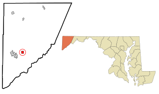
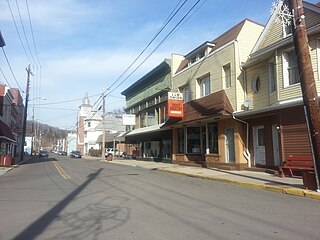
Oakland is a town in and the county seat of Garrett County, Maryland, United States. The population was 1,851 at the 2020 census. It is situated only miles from the source of the Potomac River, which flows directly into Chesapeake Bay. It is also near the Wisp Resort at Deep Creek Lake. Oakland is part of the Pittsburgh media market.

<span class="mw-page-title-main">Barton, Maryland</span> Town in Maryland, United States

Barton is a town in Allegany County, Maryland, United States, located along the Georges Creek Valley. It is part of the Cumberland, MD-WV Metropolitan Statistical Area. The population was 457 at the 2010 census.

<span class="mw-page-title-main">Lonaconing, Maryland</span> Town in Maryland, United States

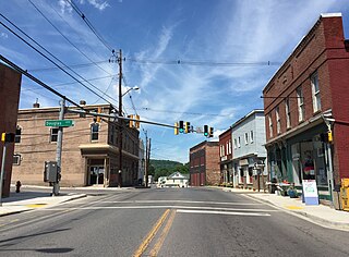
Lonaconing is a town in Allegany County, Maryland, United States, located along the Georges Creek Valley. It is part of the Cumberland, MD-WV Metropolitan Statistical Area. The population was 1,214 at the 2010 census.

<span class="mw-page-title-main">Luke, Maryland</span> Town in Maryland, United States

Luke is a town in Allegany County, Maryland, United States, located along the Potomac River just upstream of Westernport. Known originally as West Piedmont, the town is part of the Cumberland, MD-WV Metropolitan Statistical Area. The population was 85 as of the 2020 census.

<span class="mw-page-title-main">Midland, Maryland</span> Town in Maryland, United States

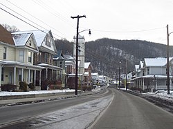
Midland is a town in Allegany County, Maryland, United States, along the Georges Creek Valley. It is part of the Cumberland, MD-WV Metropolitan Statistical Area. The population was 446 at the 2010 census. Midland was founded in 1850 as a coal-mining community, though today only some strip mining remains.

<span class="mw-page-title-main">Brunswick, Maryland</span> City in Maryland

Brunswick is a city in southwestern Frederick County, Maryland, United States. The city is located on the north bank of the Potomac River; Loudoun County, Virginia occupies the opposite shore. The population of Brunswick was 8,211 at the 2022 Census. There are three schools serving Brunswick: Brunswick Elementary School, Brunswick Middle School, and Brunswick High School.

<span class="mw-page-title-main">Rosemont, Maryland</span> Village in Maryland

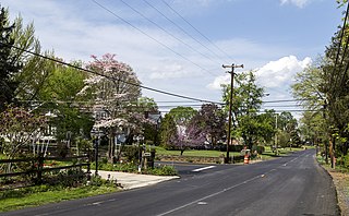
Rosemont is a village in Frederick County, Maryland, United States. The population was 272 at the 2020 census. Maryland state routes 79 and 871 pass through Rosemont.

<span class="mw-page-title-main">Deer Park, Maryland</span> Town in Maryland, United States

Deer Park is a town in Garrett County, Maryland, United States. The population was 399 at the 2010 census. It is part of the Pittsburgh Media Market.

<span class="mw-page-title-main">Grantsville, Maryland</span> Town in Maryland, United States

Grantsville is a town in the northern part of Garrett County, Maryland, United States, near the Pennsylvania border. The population was 968 as of the 2020 census.

<span class="mw-page-title-main">Kitzmiller, Maryland</span> Town in Maryland, United States

Kitzmiller is a town in Garrett County, Maryland, United States. The population was 321 at the 2010 census.

<span class="mw-page-title-main">Potomac, Maryland</span> Census-designated place in Maryland, United States

Potomac is an unincorporated community and census-designated place in Montgomery County, Maryland, United States. As of the 2020 census, it had a population of 47,018. It is named after the nearby Potomac River. A part of the Washington metropolitan area, many Potomac residents work in nearby Washington, D.C., and Northern Virginia.

<span class="mw-page-title-main">Hancock, Maryland</span> Town in Maryland, United States

Hancock is a town in Washington County, Maryland, United States. The population was 1,557 at the 2020 census. The Western Maryland community is notable for being located at the narrowest part of the state. The north–south distance from the Pennsylvania state line to the West Virginia state line is only 1.8 miles (2.9 km) at Hancock.

<span class="mw-page-title-main">Williamsport, Maryland</span> Town in Maryland, United States

Williamsport is a town in Washington County, Maryland, United States. The population was 1,868 at the 2000 census and 2,137 as of 2010.

<span class="mw-page-title-main">Carpendale, West Virginia</span> Town in West Virginia, United States

Carpendale is a town in Mineral County, West Virginia, United States, and part of the Cumberland, MD-WV Metropolitan Statistical Area'. The population was 861 at the 2020 census. Carpendale was incorporated on January 2, 1990, by the Circuit Court. The town is a combination of three subdivisions of which its name reflects: Carpenters Addition, Millerdale I, and Millerdale II. There are no stores in Carpendale and there is only one road in and out of the town.

<span class="mw-page-title-main">Elk Garden, West Virginia</span> Town in West Virginia, United States

Elk Garden is a town in Mineral County, West Virginia, United States. It is part of the 'Cumberland, MD-WV Metropolitan Statistical Area'. The population was 211 at the 2020 census. Elk Garden High School was consolidated into Keyser High School in 1997. However the Primary School is still in session, offering classes from Pre-Kindergarten through the fifth grade. The school mascot is the Elk Garden Stags. Elk Garden was incorporated in 1890 by the Mineral County Circuit Court. It is named for an elk lick near the original town site.

<span class="mw-page-title-main">Keyser, West Virginia</span> City in West Virginia, United States

Keyser is a city in and the county seat of Mineral County, West Virginia. It is part of the Cumberland, MD-WV Metropolitan Statistical Area. The population was 4,853 at the 2020 census.

<span class="mw-page-title-main">Piedmont, West Virginia</span> Town in West Virginia, United States

Piedmont is a town in Mineral County, West Virginia, United States. It is part of the Cumberland, MD-WV metropolitan statistical area. The population was 716 at the 2020 census. Piedmont was chartered in 1856 and the town is the subject of Colored People: A Memoir by Piedmont native Henry Louis Gates Jr.

<span class="mw-page-title-main">Ridgeley, West Virginia</span> Town in West Virginia, United States

Ridgeley is a town in Mineral County, West Virginia, United States, and part of the Cumberland Metropolitan Statistical Area. The population was 590 at the 2020 census.

<span class="mw-page-title-main">Paw Paw, West Virginia</span> Town in West Virginia, United States

Paw Paw is a town in Morgan County, West Virginia, United States. The population was 410 at the 2020 census. The town is known for the nearby Paw Paw Tunnel. Paw Paw was incorporated by the Circuit Court of Morgan County on April 8, 1891, and named after pawpaw, a wild fruit that grows in abundance throughout this region. Paw Paw is the westernmost incorporated community in Morgan County, and the Hagerstown-Martinsburg, MD-WV Metropolitan Statistical Area.

References

  1. "2020 U.S. Gazetteer Files". United States Census Bureau. Retrieved April 26, 2022.
  2. 1 2 U.S. Geological Survey Geographic Names Information System: Westernport, Maryland
  3. Clarke, Alan (2003). West Virginia Central and Pittsburg Railway. Lynchburg, VA: TLC Publishing. pp. 27–30. ISBN   1-883089-87-5.
  4. "US Gazetteer files 2010". United States Census Bureau . Retrieved January 25, 2013.
  5. Climate Summary for Westernport, Maryland
  6. "Census of Population and Housing". Census.gov. Retrieved June 4, 2015.
  7. "U.S. Census website". United States Census Bureau . Retrieved January 25, 2013.
  8. "U.S. Census website". United States Census Bureau . Retrieved January 31, 2008.