London Plan

Last updated

The London Plan
London Plan Cover 2017.jpg
Cover of the 2016 London Plan
Author Mayor of London
CountryEngland and United Kingdom
LanguageEnglish
SubjectStatutory planning document of Greater London
Publisher Greater London Authority
Publication date
March 2021 [1]
Media typeDigital (online and PDF)

The London Plan is the statutory spatial development strategy for the Greater London area in the United Kingdom that is written by the Mayor of London and published by the Greater London Authority. It is updated from time to time. [2]

Contents

The regional planning document was first published in final form on 10 February 2004. In addition to minor alterations, it was substantially revised and republished in February 2008 and July 2011. In October 2013, minor alterations were made to the plan to comply with the National Planning Policy Framework and other changes in national policy. [3]

The London Plan of March 2016 was published, and amended in January 2017 (for typsetting corrections), with a formal end-date of 2036.

In March 2021 a new London Plan was adopted by the Greater London Authority, planning for the next 20–25 years.

Mandate

The plan replaced the previous strategic planning guidance, or Regional Planning Guidance (RPG), for London issued by the Secretary of State and known as RPG3. [4] It is a requirement of the Greater London Authority Act 1999 that the document is produced and that it deals only with matters that are of strategic importance to Greater London. The Act also requires that the London Plan includes in its scope:

Objectives

The plan is a spatial development strategy for the Greater London area and has six objectives.

The original 2004 objectives were:

  1. To accommodate London's growth within its boundaries without encroaching on open spaces
  2. To make London a better city for people to live in
  3. To make London a more prosperous city with strong and diverse economic growth
  4. To promote social inclusion and tackle deprivation and discrimination
  5. To improve London's accessibility
  6. To make London a more attractive, well-designed and green city
London Plan, 2004

The objectives were updated in 2008 following the Greater London Authority Act 2007:

  1. To accommodate London's growth within its boundaries without encroaching on open spaces
  2. To make London a healthier and better city for people to live in
  3. To make London a more prosperous city with strong and diverse long term economic growth
  4. To promote social inclusion and tackle deprivation and discrimination
  5. To improve London's accessibility
  6. To make London an exemplary world city in mitigating and adapting to climate change and a more attractive, well-designed and green city
London Plan, 2008

The objectives as adopted by the 2011 and 2016 revisions, are to ensure that London is:

  1. a city that meets the challenges of economic and population growth
  2. an internationally competitive and successful city
  3. a city of diverse, strong, secure and accessible neighbourhoods
  4. a city that delights the senses
  5. a city that becomes a world leader in improving the environment
  6. a city where it is easy, safe and convenient for everyone to access jobs, opportunities and facilities
London Plan, 2011 and 2016

The objectives as adopted of the 2021 London plan, are to ensure that London is:

  1. Making the Best Use of Land: To promote the efficient use of land and to meet the needs of a growing population within the finite boundaries of the city.
  2. Building Strong and Inclusive Communities: To foster social integration, community engagement, and to ensure that all Londoners have access to quality services and amenities.
  3. Creating a Healthy City: To improve the health and well-being of Londoners by addressing environmental and health inequalities.
  4. Delivering the Homes Londoners Need: To increase the supply of affordable housing and to cater to the diverse housing needs of the city’s residents.
  5. Growing a Good Economy: To create opportunities for all Londoners and to ensure that the city’s economy is robust, diverse, and inclusive.
  6. Increasing Efficiency and Resilience: To make London more resilient to the challenges of climate change and to increase the efficiency of the city’s infrastructure.
London Plan, 2021 [5]

Policies

The geographical scope of the plan is the London region England Region - London.svg
The geographical scope of the plan is the London region

The 2021 plan had chapters:

ChapterTitleSummary
1Planning London’s Future - Good GrowthFocuses on building inclusive communities, making efficient use of land, fostering a healthy city, providing necessary homes, growing the economy, and increasing resilience.
2Spatial Development PatternsOpportunity areas, Strategic Development, Growth Locations, The Central Activities Zone, Town Centres, Sutton Link, and Local Regeneration,
3DesignLondon’s Character, Sustainable Infrastructure, Site Capacity Optimisation, Inclusive Design, and various design policies including tall buildings and public realm.
4HousingIncrease Housing Supply, Affordable Housing, Specialised Accommodations (elderlySpecialised Accommodations & Student).
5Social InfrastructureSocial Infrastructure, including healthcare and social care facilities, education, play areas, sports facilities, public toilets, and burial space.
6Economy Office Space, Business Space, Affordable Workspace, Industrial Locations, Sector Growth, Retail, and skills development.
7Heritage and Culture Heritage Conservation, World Heritage Sites, strategic views, culture and creative industries, the night-time economy, and protecting public houses.
8Green Infrastructure and Natural Environment Green infrastructure, the Green Belt, open spaces, urban greening, biodiversity, trees, food growing, and geodiversity.
9Sustainable Infrastructure Air Quality, Minimising Emissions, energy infrastructure, heat risk management, water infrastructure, digital connectivity, waste management, and waterways protection.
10Transport Sutton Link, Strategic Transport, Healthy Streets and Active Travel, Transport Infrastructure, Sustainable Transport Funding
11Funding the London PlanPlan Implementation, Financial Obligations, Investment Coordination, Resource Allocation
12MonitoringPerformance Tracking, Policy Impact Assessment, Adaptive Strategies, Reporting and Transparency
Annex 1Town Centre NetworkClassifies London’s larger town centres into five categories: International, Metropolitan, Major and District centres, as well as CAZ retail clusters.
Annex 2Inner and Outer London BoroughsMap of CAZ, Inner, and Outer London
Annex 3Glossary


Opportunity areas

Opportunity Areas in the London Plan 2021 are designated for significant development, aimed at supporting new housing, commercial ventures, and infrastructure improvements. These areas are linked to existing or planned public transport enhancements and are expected to support a minimum of 5,000 new jobs or 2,500 homes, or a combination thereof. Boroughs use these figures as starting points for policy development and refine them through further assessment. Overlapping with Strategic Areas for Regeneration, Opportunity Areas are intended to support city-wide inclusive growth. The Mayor’s role includes ensuring these areas reach their full potential, advocating for investment, and overseeing development that respects the area’s character. Opportunity Area Planning Frameworks guide the initial stages of development, emphasising job creation, housing, transport, and service access, with a collaborative approach involving local communities and stakeholders. [6]

Sub-regions

Development must not encroach on green spaces London Landsat.jpg
Development must not encroach on green spaces

For the purposes of the plan, London is divided into five sub-regions. From 2004 to 2008 the sub-regions were initially the same as the Learning and Skills Council areas established in 1999. [7] Within this scheme there was a separate Central sub-region and four others around it. The London part of the Thames Gateway zone was entirely contained within the East London sub-region. The 2004–08 sub-regions each had a Sub-Regional Development Framework. [8]

The sub-regions were revised in February 2008 as part of the Further Alterations to the London Plan. These sub-regions each radiated from the centre to combine inner and outer London boroughs. [9] The 2008–11 sub-regions, each had its own Sub Regional Implementation Framework. [10]

In 2011 the sub-regions were revised again. A smaller Central sub-region was reintroduced, the South sub-region was reintroduced, and all boroughs in the Thames Gateway were returned to the East sub-region. [11] The 2011 sub-regions are maintained in the 2016 London Plan. [12]

Throughout these revisions has been a separately defined Central Activities Zone which includes areas with a very high concentration of metropolitan activities.

Activity centres

Sutton, a metropolitan centre 1 Crossroads Sutton Surrey London.JPG
Sutton, a metropolitan centre

The London Plan identifies 201 activity centres in the city. All activity centres are categorised into:

Smaller local and neighbourhood centres are also referred to in the plan but are not listed.

International centres (2) Knightsbridge, West End
Metropolitan centres (14) Bromley, Canary Wharf, Croydon, Ealing, Harrow, Hounslow, Ilford, Kingston, Romford, Shepherd's Bush, Stratford, Sutton, Uxbridge, Wood Green
Major centres (36) Angel, Barking, Bexleyheath, Brixton, Camden Town, Canada Water, Catford, Chiswick, Clapham Junction, Dalston, East Ham, Edgware, Elephant and Castle/Walworth Road, Eltham, Enfield Town, Fulham, Hackney Central, Hammersmith, Kensington High Street, Kilburn, King's Road (East), Lewisham, Nag's Head, Orpington, Peckham, Putney, Queensway/Westbourne Grove, Richmond, Southall, Streatham, Tooting, Walthamstow, Wandsworth, Wembley, Wimbledon, Woolwich
District centres (149) Acton, Addiscombe, Angel Edmonton, Archway, Bakers Arms, Balham, Barkingside, Beckenham, Bethnal Green, Blackheath, Brent Street, Brentford, Brick Lane, Brompton Cross, Bruce Grove/Tottenham High Road, Burnt Oak, Camberwell, Canning Town, Carshalton Village, Chadwell Heath, Cheam Village, Chipping Barnet, Chrisp Street, Church End Finchley, Clapham High Street, Colindale/The Hyde, Collier Row, Coulsdon, Crayford, Cricklewood, Crouch End, Dagenham Heathway, Deptford, Downham, Dulwich – Lordship Lane, Ealing Road, Earls Court Road, Earlsfield, East Beckton, East Finchley, East Greenwich, East Sheen, Eastcote, Edgware Road/Church Street, Edmonton Green, Elm Park, Erith, Feltham High Street, Finsbury Park, Forest Gate, Forest Hill, Fulham Road, Gants Hill, Golders Green, Green Lane, Green Lanes, Green Street, Greenford, Greenwich West, Hampstead, Hanwell, Harlesden, Harold Hill, Harrow Road, Hayes, Hendon Central, Herne Hill, Highams Park, Hornchurch, Kentish Town, Kenton, King's Road (West), Kingsbury, Lavender Hill/Queenstown Road, Lee Green, Leyton, Leytonstone, Mill Hill, Mitcham, Morden, Muswell Hill, Neasden, New Addington, New Barnet, New Cross and New Cross Gate, New Malden, Norbury, North Cheam, North Chingford, North Finchley, North Harrow, Northwood, Notting Hill Gate, Palmers Green, Penge, Petts Wood, Pinner, Plumstead, Portobello, Praed Street/Paddington, Preston Road, Purley, Rainham, Rayners Lane, Roman Road (East), Roman Road (West), Rosehill, Ruislip, St John's Wood, Selsdon, Sidcup, South Chingford, South Harrow, South Kensington, South Norwood, South Woodford, Southgate, Stamford Hill, Stanmore, Stockwell, Stoke Newington, Surbiton, Swiss Cottage/Finchley Road, Sydenham, Teddington, Temple Fortune, Thamesmead, Thornton Heath, Tolworth, Twickenham, Upminster, Upper Norwood/Crystal Palace, Wallington, Wanstead, Watney Market, Wealdstone, Welling, Wembley Park, West Green Road/Seven Sisters, West Hampstead, West Norwood/Tulse Hill, West Wickham, Whetstone, Whitechapel, Whitton, Willesden Green, Wood Street, Worcester Park, Yiewsley/West Drayton

Alterations

There have been a number of amendments to the London Plan which have been incorporated into the current version that was published in February 2008. Early alterations were made covering housing provision targets, waste and minerals. Further alterations to the plan covered climate change; London as a world city; The London Economy; Housing; Tackling social exclusion; Transport; London's geography, the sub-regions and inter-regions; Outer London; Liveability (including safety, security and open spaces); and the 2012 Olympic Games and Paralympic Games. The mayor gained new statutory powers following the Greater London Authority Act 2007.

Following the 2008 change of mayor, a new review was initiated in July 2008 and a new London Plan published in July 2011. As of this date, modifications are made to fully comply with the National Planning Policy Framework.

In 2013, London Mayor Boris Johnson proposed early minor alterations to the London Plan that were aimed at preventing boroughs from setting rent caps or targets for affordable rented homes in their local development frameworks. [13] The alterations were approved in a vote by the London Assembly in September 2013. [14]

Alterations made since July 2011 were consolidated in the London Plan of March 2016, which re-published with typsetting corrections in January 2017.

Following the 2016 change of mayor, London Mayor Sadiq Khan outlined proposals towards creating a new London Plan. [15] A draft version was published in December 2017, with the final version formally coming into effect on 2 March 2021. [16]

DateDocument
February 2004The London Plan 2004 [lower-alpha 1] [17]
October 2005Draft Alterations to the London Plan: Housing Provision Targets Waste and Minerals
December 2005Reviewing the London Plan: Statement of Intent from the Mayor
September 2006Draft Further Alterations to the London Plan
December 2006Early Alterations to the London Plan on Housing provision targets, waste and minerals
February 2008The London Plan 2008 [lower-alpha 1] [18]
July 2008Planning for a better London
April 2009A new plan for London: Proposals for the Mayor's London Plan
October 2009The London Plan: Consultation draft replacement plan
December 2009Minor alteration to the consultation draft replacement London Plan
April 2010Crossrail Alterations
July 2011The London Plan 2011 [lower-alpha 1] [19] [20]
February 2012Early Minor Alterations to the London Plan
October 2013Revised Early Minor Alterations to the London Plan
March 2015Further Alterations to the London Plan
March 2016
(typsetting corrections January 2017)
The London Plan 2016 [lower-alpha 1] [21]
December 2017Draft version of the updated London Plan released for consultation
August 2018Minor changes published
March 2021The London Plan 2021 [lower-alpha 1] [1]
  1. 1 2 3 4 5 Short title.

Related Research Articles

<span class="mw-page-title-main">Mayor of London</span> Head of the government of Greater London

The mayor of London is the chief executive of the Greater London Authority. The role was created in 2000 after the Greater London devolution referendum in 1998, and was the first directly elected mayor in the United Kingdom.

<span class="mw-page-title-main">Greater London Authority</span> English devolved regional authority

The Greater London Authority (GLA), colloquially known by the metonym City Hall, is the devolved regional governance body of Greater London, England. It consists of two political branches: an executive Mayor and the 25-member London Assembly, which serves as a means of checks and balances on the Mayor. Since May 2016, both branches have been under the control of the London Labour Party. The authority was established in 2000, following a local referendum, and derives most of its powers from the Greater London Authority Act 1999 and the Greater London Authority Act 2007.

<span class="mw-page-title-main">Green belt (United Kingdom)</span> British urban planning policy to maintain countryside around cities

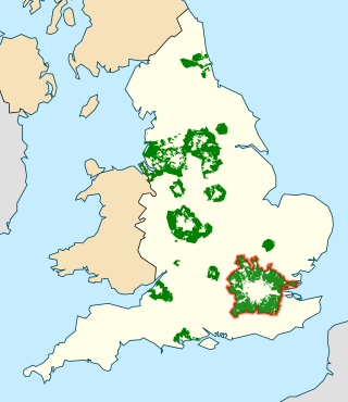
In British town planning, the green belt is a policy for controlling urban growth. The term, coined by Octavia Hill in 1875, refers to a ring of countryside where urbanisation will be resisted for the foreseeable future, maintaining an area where local food growing, forestry and outdoor leisure can be expected to prevail. The fundamental aim of green belt policy is to prevent urban sprawl by keeping land permanently green, and consequently the most important attribute of green belts is their openness.

<span class="mw-page-title-main">South London</span> London south of the River Thames, in England

South London is the southern part of London, England, south of the River Thames. The region consists of the boroughs, in whole or in part, of Bexley, Bromley, Croydon, Greenwich, Kingston, Lambeth, Lewisham, Merton, Richmond, Southwark, Sutton and Wandsworth.

<span class="mw-page-title-main">Regional assembly (England)</span> Former regional bodies in England

The regional chambers of England were a group of indirectly elected regional bodies that were created by the provisions of the Regional Development Agencies Act 1998. There were eight regional chambers, one for each of the regions of England except Greater London, which had opted for an elected mayor and assembly in 1998. All eight regional chambers had adopted the title "regional assembly" or "assembly" as part of their name, though this was not an official status in law. The chambers were abolished over a two-year period between 31 March 2008 and 31 March 2010 and some of their functions were assumed by newly established local authority leaders' boards.

<span class="mw-page-title-main">London Riverside</span>

The London Riverside is a redevelopment area on the north side of the River Thames in East London, England. The area was identified as a zone of change following the introduction of the Thames Gateway policy in 1995. Proposals for improvements in the area were at first developed by Havering and Barking and Dagenham councils, with a London Riverside Urban Strategy published in 2002. This was incorporated into the first London Plan published by the Mayor of London in 2004. Between 2004 and 2013 the planning powers in London Riverside and the Lower Lea Valley were the responsibility of the London Thames Gateway Development Corporation. Planning powers have now reverted to the local councils. Much of the land available for redevelopment is now owned by GLA Land and Property. There is also a London Riverside business improvement district, which covers a smaller area.

<span class="mw-page-title-main">Liverpool City Region</span> Combined authority area in Northern England

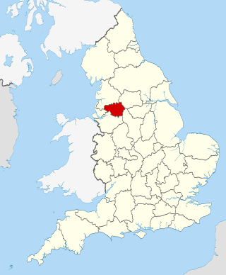
Liverpool City Region is a combined authority area in North West England. It has six council areas; five Merseyside metropolitan boroughs and the Cheshire unitary authority of Halton. The region had a population of 1,571,045 in 2022.

Regional spatial strategies (RSS) provided regional level planning frameworks for the regions of England outside London. They were introduced in 2004. Their revocation was announced by the new Conservative/Liberal Democrat government on 6 July 2010.

<span class="mw-page-title-main">Local development framework</span>

A local development framework is the spatial planning strategy introduced in England and Wales by the Planning and Compulsory Purchase Act 2004 and given detail in Planning Policy Statements 12. In most parts of the two countries, maintaining the framework is the responsibility of English district councils and Welsh principal area councils.

In England, spatial planning is undertaken at the national level, through the National Planning Policy Framework. The London region is the only one to have a statutory London Plan. Most planning functions are exercised by local authorities, with neighbourhood planning also taking place in some areas.

The Docklands Light Railway extension to Dagenham Dock was a proposed extension of the Docklands Light Railway (DLR) to Dagenham Dock in East London, to serve the Barking Riverside development and the wider London Riverside part of the Thames Gateway.

<span class="mw-page-title-main">Leeds City Region</span> City region and Local enterprise partnership in England

The Leeds City Region, or informally Greater Leeds, is a local enterprise partnership city region located in West Yorkshire, England. Prior to the West Yorkshire devolution deal, the partnership covered parts of South and North Yorkshire. According to the Office for National Statistics, as of 2017 the city region ranked 2nd behind Greater London for both population and GVA in the United Kingdom. It has a population of 2,320,214 million and a GVA of £69.62 billion.

<span class="mw-page-title-main">Greater Manchester Combined Authority</span> Local government body in North West England

The Greater Manchester Combined Authority (GMCA) is a combined authority for Greater Manchester, England. It was established on 1 April 2011 and consists of 11 members; 10 indirectly elected members, each a directly elected councillor from one of the ten metropolitan boroughs that comprise Greater Manchester, together with the directly elected Mayor of Greater Manchester. The authority derives most of its powers from the Local Government Act 2000 and Local Democracy, Economic Development and Construction Act 2009, and replaced a range of single-purpose joint boards and quangos to provide a formal administrative authority for Greater Manchester for the first time since the abolition of Greater Manchester County Council in 1986.

<span class="mw-page-title-main">Metropolitan Green Belt</span> Statutory green belt around London, England

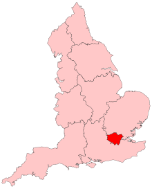
The Metropolitan Green Belt is a statutory green belt around London, England. It comprises parts of Greater London, Berkshire, Buckinghamshire, Essex, Hertfordshire, Kent and Surrey, parts of two of the three districts of Bedfordshire and a small area in Copthorne, Sussex. As of 2017/18, Government statistics show the planning designation covered 513,860 hectares of land.

<span class="mw-page-title-main">Brent Cross Cricklewood</span>

Brent Cross Cricklewood is a new town centre development under construction in Hendon and Cricklewood, London, United Kingdom. The development is planned to cost around £4.5 billion to construct and will include 6,700 homes, workspace for 25,000 people, four parks, transport improvements and a 592,000 sq ft (55,000 m2) extension of Brent Cross Shopping Centre. The developers of the scheme are Hammerson and Standard Life.

The Metro Manila Dream Plan, formally titled the Roadmap for Transport Infrastructure Development for Metro Manila and Its Surrounding Areas, refers to a 2014 integrated plan for improving the transport system in Metro Manila, Philippines, with the hope of turning it into a focal point for addressing Metro Manila's interlinked problems in the areas of transportation, land use, and environment.

<span class="mw-page-title-main">Mayor of Greater Manchester</span> Political official in Greater Manchester

The Mayor of Greater Manchester is the directly elected mayor of Greater Manchester, responsible for strategic governance in the region that includes health, transport, housing, strategic planning, waste management, policing, the Greater Manchester Fire and Rescue Service and skills. The creation of the Mayor of Greater Manchester was agreed between the then Chancellor of the Exchequer, George Osborne, and Greater Manchester's 10 district council leaders. As well as having specific powers, the mayor chairs the Greater Manchester Combined Authority, also assuming the powers of the Greater Manchester Police and Crime Commissioner.

The Docklands Light Railway extension to Thamesmead is a proposed Docklands Light Railway (DLR) extension to serve the Beckton Riverside and Thamesmead redevelopment areas of East London.

<span class="mw-page-title-main">West London</span> Western part of London, England

West London is the western part of London, England, north of the River Thames, west of the City of London, and extending to the Greater London boundary.

References

  1. 1 2 Khan, Sadiq (Mayor of London) (March 2021). The London Plan - The Spatial Development Strategy for Greater London (PDF). London: Greater London Authority. ISBN   978-1-84781-739-6. Archived (PDF) from the original on 25 May 2023. Retrieved 6 September 2023.
  2. "The London Plan, Web page". London City Hall. 8 June 2023.
  3. Mayor of London (October 2013). "REMA". London Assembly. Retrieved 1 May 2017.
  4. "Strategic Guidance for London Planning Authorities" (PDF). regulations.completepicture.co.uk.[ permanent dead link ]
  5. "London Plan 2021" (PDF). london.gov.uk. 2014. p. 12. Retrieved 10 May 2024.
  6. "London Plan 2021" (PDF). london.gov.uk. 2014. p. 32. Retrieved 10 May 2024.
  7. Addison & Associates (June 2006). "Review of London's Sub Regional Boundaries" (PDF). Greater London Authority. Archived from the original (PDF) on 4 June 2011.
  8. Mayor of London (May 2006). "Sub Regional Development Frameworks". Greater London Authority. Archived from the original on 9 November 2008.
  9. Mayor of London (February 2008). "The London Plan: Sub-regions, CAZ and government growth area policies". Greater London Authority. Archived from the original on 13 July 2009.
  10. Mayor of London (September 2006). "Draft Further Alterations to the London Plan" (PDF). Greater London Authority. Archived from the original (PDF) on 4 June 2011.
  11. Mayor of London (March 2016). "London Plan 2016, Chapter 2" (PDF). London Assembly. Retrieved 1 May 2017.
  12. Mayor of London (March 2016). "London Plan 2016, Chapter 2". London Assembly. Retrieved 1 May 2017.
  13. Labour group fails in bid to block London Plan revisions. Planning Resource (4 September 2013). Retrieved on 6 December 2013.
  14. Mayor could face legal challenge to London Plan alterations. Out-law.com. Retrieved on 6 December 2013.
  15. Mayor outlines plans to create 'A City for all Londoners'. london.gov.uk. Retrieved on 1 May 2017.
  16. London Plan 2021 - Planning (Presentation) (PDF) (Report). Mayor of London. March 2021. p. 12.
  17. Livingstone, Ken (Mayor of London) (February 2004). The London Plan - Spatial Development Strategy for Greater London. London: Greater London Authority. ISBN   1-85261-544-3. Archived from the original on 6 September 2023. Retrieved 6 September 2023.
  18. Livingstone, Ken (Mayor of London) (February 2008). The London Plan - Spatial Development Strategy for Greater London - Consolidated with Alterations since 2004. London: Greater London Authority. ISBN   978-1-84781-129-5. Archived from the original on 25 June 2023. Retrieved 6 September 2023.
  19. Johnson, Boris (Mayor of London) (July 2011). "Cover / Contents / Mayor's Forward / Overview and Introduction". The London Plan - Spatial Development Strategy for Greater London. London: Greater London Authority. pp. Front cover–14. ISBN   978-1-84781-451-7. Archived from the original on 6 September 2023. Retrieved 6 September 2023.
  20. "London Plan 2011". Greater London Authority. July 2011. Archived from the original on 27 June 2023. Retrieved 6 September 2023. [web portal to chapter documents, per:] The Mayor published the replacement London Plan in July 2011. It is available to download by chapter below.
  21. Johnson, Boris (Mayor of London) (March 2016). The London Plan - The Spatial Development Strategy for London - Consolidated with Alterations Since 2011 (PDF) (January 2017 (typsetting corrections) ed.). London: Greater London Authority. Archived (PDF) from the original on 2 July 2023. Retrieved 6 September 2023.