
Monroe County is a county in the Commonwealth of Pennsylvania. It is located in Northeastern Pennsylvania. As of the 2020 census, the population was 168,327. Its county seat is Stroudsburg. The county was formed from sections of Northampton and Pike counties on April 1, 1836.
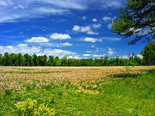
Tunkhannock Township is a township in Monroe County, Pennsylvania, United States. The population was 7,037 at the 2020 census. Tunkhannock Township comprises the communities of Blakeslee and Long Pond. The most noteworthy feature of this township is the Tunkhannock creek, which forms "Long Pond", and is designated by the PA DEP as an Exceptional Value Waters (EV). The Bethlehem Authority, Nature Conservancy, Wildlands Conservancy County of Monroe Open Space Program, and PA Department of Forest and Waters have protected thousands of acres. Tunkhannock Township, PA is home to many species of globally rare, threatened, and endangered plants and animals and has been described as one of the last "great places".

Bowman Creek is a tributary of the Susquehanna River in Luzerne County and Wyoming County, in Pennsylvania, in the United States. It is approximately 26 miles (42 km) long and flows through Ross Township and Lake Township in Luzerne County and Noxen Township, Monroe Township, and Eaton Township in Wyoming County. The watershed of the creek has an area of 120 square miles (310 km2). The creek is not designated as an impaired waterbody and its pH is close to neutral, although it has experienced some problems with acid rain. It has low concentrations of dissolved solids like calcium. The creek is relatively small in its upper reaches, but by Noxen, its width is 40 to 60 feet. It is also relatively shallow in many reaches. Rock formations in the watershed include the Catskill Formation, the Huntley Mountain Formation, Burgoon Sandstone, the Mauch Chunk Formation, the Pottsville Group, and the Pocono Formation. Soil associations in the creek's watershed include the Wellsboro-Morris-Oquaga association, the Oquaga-Lackawanna-Arnot association, the Mardin-Bath-Volusia association, and the Wyoming-Pope association.
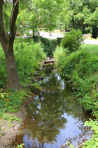
Tunkhannock Creek is a 19.2-mile-long (30.9 km) tributary of Tobyhanna Creek in the Poconos of eastern Pennsylvania in the United States.

Abrahams Creek is a tributary of the Susquehanna River in Luzerne County, Pennsylvania, in the United States. It is approximately 10.7 miles (17.2 km) long and flows through Franklin Township, Dallas Township, Kingston Township, West Wyoming, Wyoming, and Forty Fort. The watershed of the creek has an area of 17.4 square miles (45 km2) and occupies portions of nine municipalities in northeastern Luzerne County. The watershed is divided into the upper Abraham Creek watershed and the lower Abraham Creek watershed, which are joined by a canyon known as The Hollow. The upper part of the watershed is mostly rural, but the lower part is heavily urbanized. The creek's channel has been heavily modified in many places. Its drainage basin is designated as a Coldwater Fishery and a Migratory Fishery.
Swale Brook is a tributary of Tunkhannock Creek in Wyoming County, Pennsylvania, in the United States. It is approximately 2.9 miles (4.7 km) long and flows through Tunkhannock Township and Tunkhannock. The watershed of the stream has an area of 4.01 square miles (10.4 km2). The stream is not designated as an impaired waterbody. The surficial geology near it consists of alluvium, alluvial terrace, Wisconsinan Outwash, Wisconsinan Till, Wisconsinan Ice-Contact Stratified Drift, fill, and a wetland.

Kern Glen Creek is a tributary of Billings Mill Brook in Wyoming County, Pennsylvania, in the United States. It is approximately 3.1 miles (5.0 km) long and flows through Lemon Township and Tunkhannock Township. The watershed of the creek has an area of 2.71 square miles (7.0 km2). The creek is not designated as an impaired waterbody. The surficial geology in its vicinity mostly consists of Wisconsinan Till.

South Branch Tunkhannock Creek is a tributary of Tunkhannock Creek in Lackawanna County and Wyoming County, in Pennsylvania, in the United States. It is approximately 22.5 miles (36.2 km) long and flows through Scott Township, Benton Township, North Abington Township, and La Plume Township in Lackawanna County and Clinton Township, Factoryville, and Tunkhannock Township in Wyoming County. The watershed of the creek has an area of 98.3 square miles (255 km2). The creek's named tributaries include Trout Brook, Ackerly Creek, and Kennedy Creek. South Branch Tunkhannock Creek is not designated as an impaired waterbody and has relatively good water quality.
Ackerly Creek is a tributary of South Branch Tunkhannock Creek in Lackawanna County, Pennsylvania, in the United States. It is approximately 8.7 miles (14.0 km) long and flows through South Abington Township, Waverly Township, Glenburn Township, Dalton, and La Plume Township. The creek has several unnamed tributaries and drains an area of nearly 18 square miles (47 km2). Ackerly Creek is not designated as an impaired waterbody, but it is impacted by some water quality problems. In one reach, the creek flows through Rabbit Hollow, which is set aside as a preserve. The creek experiences some erosion due to its banks being managed and straightened where it flows alongside US Route 6 and US Route 11.

Kennedy Creek is a tributary of South Branch Tunkhannock Creek in Lackawanna County, Pennsylvania, in the United States. It is approximately 5.3 miles (8.5 km) long and flows through Scott Township and North Abington Township. The watershed of the creek has an area of 6.17 square miles (16.0 km2). The creek is not designated as an impaired waterbody. The surficial geology in its vicinity consists of Wisconsinan Till, alluvium, bedrock, and fill.

Oxbow Creek is a tributary of Tunkhannock Creek in Wyoming County, Pennsylvania, in the United States. It is approximately 2.5 miles (4.0 km) long and flows through Lemon Township. The watershed of the creek has an area of 8.56 square miles (22.2 km2). The creek has two named tributarie: Horton Creek and Oxbow Inlet. It is not designated as an impaired waterbody. The surficial geology in its vicinity mostly consists of Wisconsinan Till, alluvium, Wisconsinan Ice-Contact Stratified Drift, and bedrock.

Monroe Creek is a tributary of Tunkhannock Creek in Susquehanna County and Wyoming County, in Pennsylvania, in the United States. It is approximately 6.1 miles (9.8 km) long and flows through Springville Township in Susquehanna County and Nicholson Township in Wyoming County. The watershed of the creek has an area of 6.64 square miles (17.2 km2). The creek is not designated as an impaired waterbody. The surficial geology in its vicinity consists mostly of alluvium, Wisconsinan Till, and other things. Its watershed is designated as a Coldwater Fishery and a Migratory Fishery.

Field Brook is a tributary of Tunkhannock Creek in Susquehanna County and Wyoming County, in Pennsylvania, in the United States. It is approximately 5.8 miles (9.3 km) long and flows through Lathrop Township in Susquehanna County and Nicholson Township in Wyoming County. The watershed of the stream has an area of 7.41 square miles (19.2 km2). The stream has one named tributary, which is known as East Branch Field Brook. The surficial geology in the vicinity of Field Brook consists of alluvium, Wisconsinan Till, alluvial terrace, alluvial fan, bedrock, wetlands, and a lake. The watershed of the stream is designated as a Coldwater Fishery and a Migratory Fishery.

Horton Creek is a tributary of Tunkhannock Creek in Susquehanna County and Wyoming County, in Pennsylvania, in the United States. It is approximately 11 miles (18 km) long and flows through Brooklyn Township and Lathrop Township in Susquehanna County and Nicholson Township and Nicholson in Wyoming County. The watershed of the creek has an area of 16.9 square miles (44 km2). The creek is not designated as an impaired waterbody and has no named tributaries. The topography of the creek's watershed has been described as "rough and hilly" and its channel is sinuous.
Millard Creek is a tributary of Tunkhannock Creek in Susquehanna County, Pennsylvania. It is approximately 6.2 miles (10.0 km) long and flows through Harford Township and Lenox Township. The watershed of the creek has an area of 5.66 square miles (14.7 km2). The creek is not designated as an impaired waterbody. The surficial geology in its vicinity includes Wisconsinan Till, alluvium, wetlands, lakes, bedrock, and alluvial fan. The dominant land uses in the creek's watershed include forested land and agricultural land. A number of bridges have been constructed over the creek. Its drainage basin is designated as a Coldwater Fishery and a Migratory Fishery.
Tower Branch is a tributary of Tunkhannock Creek in Susquehanna County, Pennsylvania, in the United States. It is approximately 4.8 miles (7.7 km) long and flows through Harford Township and Lenox Township. The watershed of the stream has an area of 3.69 square miles (9.6 km2). The stream is not designated as an impaired waterbody and has no named tributaries. The surficial geology in its vicinity consists mainly of Wisconsinan Till, alluvium, with some lakes, wetlands, bedrock, and alluvial fan. The stream's drainage basin is classified as a Coldwater Fishery and a Migratory Fishery.
Partners Creek is a tributary of Tunkhannock Creek in Susquehanna County, Pennsylvania, in the United States. It is approximately 6.4 miles (10.3 km) long and flows through Harford Township and Lenox Township. The watershed of the creek has an area of 5.84 square miles (15.1 km2). The creek has one named tributary, which is known as Sterling Brook. The drainage basin of Partners Creek is classified as a Coldwater Fishery and a Migratory Fishery. The surficial geology in the vicinity of the creek consists of Wisconsinan Till, alluvium, bedrock, wetlands, lakes, and alluvial fan.
Nine Partners Creek is a tributary of Tunkhannock Creek in Susquehanna County, Pennsylvania, in the United States. It is approximately 10 miles (16 km) long and flows through New Milford Township, Harford Township, and Lenox Township. The watershed of the creek has an area of 38.6 square miles (100 km2). The creek has two named tributaries: Butler Creek and Leslie Creek. The surficial geology in the vicinity of Nine Partners Creek includes Wisconsinan Till, alluvium, bedrock, alluvial fan, and wetlands. The creek's drainage basin is designated as a Coldwater Fishery and a Migratory Fishery.

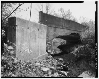
Bell Creek is a tributary of Tunkhannock Creek in Susquehanna County, Pennsylvania, in the United States. It is approximately 5.2 miles (8.4 km) long and flows through Gibson Township. The watershed of the creek has an area of 5.64 square miles (14.6 km2). The surficial geology the creek's vicinity includes Wisconsinan Till, alluvium, bedrock, wetlands, lakes, and alluvial fan. It has no named tributaries, but does flow through a lake known as Potter Lake. A bridge on the National Register of Historic Places crosses Bell Creek as well. The creek's watershed is designated as a Coldwater Fishery and a Migratory Fishery.
Dundaff Creek is a tributary of East Branch Tunkhannock Creek in Susquehanna County and Lackawanna County, in Pennsylvania, in the United States. It is approximately 6.7 miles (10.8 km) long and flows through Clifford Township in Susquehanna County and Greenfield Township in Lackawanna County. The watershed of the creek has an area of 10.3 square miles (27 km2). The creek has no named tributaries and is not designated as an impaired waterbody.


