
Hampden County is a non-governmental county located in the Pioneer Valley of the state of Massachusetts, in the United States. As of the 2020 census, Hampden County's population was 465,825. Its traditional county seat is Springfield, the Connecticut River Valley's largest city, and economic and cultural capital; with an estimated population of 154,758, approximately 1 in 3 residents of Hampden County live in Springfield. Hampden County was split from Hampshire County in 1812, because Northampton, Massachusetts, was made Hampshire County's "shire town" in 1794; however, Springfield—theretofore Hampshire County's traditional shire town, dating back to its founding in 1636—grew at a pace far quicker than Northampton and was granted shire town-status over its own, southerly jurisdiction. It was named for parliamentarian John Hampden. To the north of Hampden County is modern-day Hampshire County; to the west is Berkshire County; to the east is Worcester County; to the south are Litchfield County, Hartford County, and Tolland County in Connecticut. Hampden County is part of the Springfield, MA Metropolitan Statistical Area. It is the most urban county in Western Massachusetts. The Knowledge Corridor surrounding Springfield-Hartford is New England's second most populous urban area with 1.9 million people.

Springfield is a city in and the seat of Hampden County, Massachusetts, United States. Springfield sits on the eastern bank of the Connecticut River near its confluence with three rivers: the western Westfield River, the eastern Chicopee River, and the eastern Mill River. At the 2020 census, the city's population was 155,929, making it the third-largest city in the Commonwealth of Massachusetts and the fourth-most populous city in New England after Boston, Worcester, and Providence. Metropolitan Springfield, as one of two metropolitan areas in Massachusetts, had a population of 699,162 in 2020.

Chicopee is a city located on the Connecticut River in Hampden County, Massachusetts, United States. As of the 2020 census, the city had a population of 55,560, making it the second-largest city in Western Massachusetts after Springfield. Chicopee is part of the Springfield, Massachusetts Metropolitan Statistical Area. The communities of Chicopee Center (Cabotville), Chicopee Falls, Willimansett, Fairview, Aldenville, Burnett Road, Smith Highlands and Westover are located within the city.

The Pioneer Valley is the colloquial and promotional name for the portion of the Connecticut River Valley that is in Massachusetts in the United States. It is generally taken to comprise the three counties of Hampden, Hampshire, and Franklin. The lower Pioneer Valley corresponds to the Springfield, Massachusetts metropolitan area, the region's urban center, and the seat of Hampden County. The upper Pioneer Valley region includes the smaller cities of Northampton and Greenfield, the county seats of Hampshire and Franklin counties, respectively.

Springfield is a historic neighborhood of Jacksonville, Florida, United States, located to the north of downtown. Established in 1869, it experienced its greatest growth from the early 1880s through the 1920s. The Springfield Historic District is listed in the National Register of Historic Places, and contains some of the city's best examples of 19th and early 20th century architecture.
Springfield Technical Community College is a public Hispanic-serving technical college in Springfield, Massachusetts. It is the only technical community college in the Commonwealth of Massachusetts. Located on the site of the Springfield Armory National Park, which was founded by Henry Knox and George Washington during the Revolutionary War, Springfield Technical Community College now occupies many of the buildings used by the U.S. Armory at Springfield prior to the Armory's closure in 1969. While 20 acres (81,000 m2) of the 55-acre (220,000 m2) site remain in the hands of the U.S. National Park Service for historic preservation, 35 acres (140,000 m2) comprise the college campus. Numerous historic buildings have been repurposed as classrooms, in addition to newer facilities built on-site.

The Winchester Repeating Arms Company Historic District is a historic district in New Haven, Connecticut that was listed on the National Register of Historic Places in 1988. It includes 867 properties, which "include 858 major structures and 131 notable outbuildings." Of these structures, 876 are buildings deemed to contribute to the historical and/or architectural significance of the area, and most of these are residential. However the center of the district is "dominated" by the 75-acre (30 ha) tract of the former Winchester Repeating Arms Company, which contains industrial buildings.

Apremont Triangle Historic District is a historic district in Springfield, Massachusetts, located at the junction of Pearl, Hillman, Bridge, and Chestnut Streets in its Metro Center district. The Apremont Triangle Historic District includes the Apremont Triangle Park, nicknamed "the Heart of Springfield" by the city's arts community; the historic, 10-story Kimball Towers Condominiums, a nine-story historic, former YMCA, which now houses apartments at 122 Chestnut Street, (1915); the six-story Neo-Gothic Tarbell-Waters Building (1923), a former office building that was auctioned in August 2011; the two-story Harris-Green building, a 1920s Rolls-Royce showroom, which is, actually, two buildings; and the two-story Birnie Building, a 1930s Pontiac showroom. Currently, the district is the center of Springfield's bohemian arts community, featuring multi-media organizations, artists' lofts, ethnic restaurants, and organizations like The Apremont Arts Community - group of multi-media artists, non-profit organizations, and businesses.
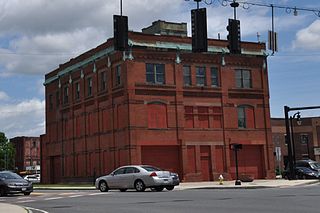
Winchester Square Historic District is a historic district encompassing a cluster of brick buildings at and near the intersection of State Street and Wilbraham Road on the east side of Springfield, Massachusetts. The buildings, most of which were built for industrial purposes, are clustered on five parcels, and were built between 1875 and 1913. It includes the Armory railroad station (1875), the Winchester Square fire station, the Knox Automobile Company buildings (1891-1910), and the Indian Motorcycle Company plant, part of which later became the Springfield Industrial Institute complex. The district was listed on the National Register of Historic Places in 1979.

The Quadrangle–Mattoon Street Historic District is a historic district in Springfield, Massachusetts, bounded by Chestnut Street to the West; State Street to the South; and includes properties on Mattoon, Salem, Edwards and Elliot Streets. Located in the Metro Center, the Quadrangle–Mattoon Street Historic District is one of the few neighborhoods in the Knowledge Corridor lined with historic, restored red-brick Victorian row houses on both sides, covered by tree canopies.

The Gunn and Hubbard Blocks are a pair of historic commercial-residential buildings at 463-477 State Street in the Old Hill section of Springfield, Massachusetts. Located across the street from the Springfield Armory, they were built in the 1830s, and are the two of the oldest commercial buildings in Springfield. The buildings were listed on the National Register of Historic Places in 1980.
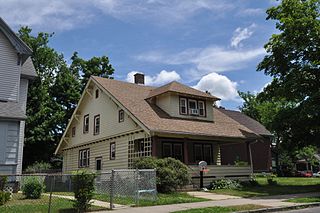
The McKnight District is a predominantly residential neighborhood northeast of downtown Springfield, Massachusetts. The area represents a planned residential development covering several hundred acres, which was built in the mid to late 19th century. The architects of the development were John and William McKnight, who, in addition to developing and enforcing construction guidelines in the area, built and landscaped many of the properties. The area was largely built by 1910, and there has been little new construction in the area since. Most of the houses built in the area were constructed in most of the architectural styles that were popular between 1880 and 1990, although there is a predominance of the Queen Anne style. The McKnights began to develop the area, which had previously been mainly farmland, in 1870 with the purchase of a 22 acres (8.9 ha) parcel on which they and a partner built their own homes. They proceeded over the following years to acquire additional parcels of land in the area, plat out roads, and either build houses themselves, or sell plots to other builders. They enforced some uniformity in the area through the use of deed restrictions, which required uniform setback requirements, banned fencing, and required a minimum cost of construction.
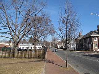
Mulberry Street is a historic street and tourist destination in Springfield, Massachusetts. Made famous by Dr. Seuss' first children's book And to Think That I Saw It on Mulberry Street, the street is less than one mile from Springfield's Metro Center neighborhood, the Springfield Armory, and the Quadrangle. It is also less than one mile southwest of Dr. Seuss' boyhood home on Fairfield Street.

Metro Center is the original colonial settlement of Springfield, Massachusetts, located beside a bend in the Connecticut River. As of 2019, Metro Center features a majority of Western Massachusetts' most important cultural, business, and civic venues. Metro Center includes Springfield's Central Business District, its Club Quarter, its government center, its convention headquarters, and in recent years, it has become an increasingly popular residential district, especially among young professionals, empty-nesters, and creative types, with a population of approximately 7,000 (2010.)
The Bay neighborhood is located in Springfield, Massachusetts. It covers 556.5 acres of land, making it one of the city's smallest neighborhoods.
Watershops Pond is a lake in the city of Springfield, Massachusetts. Located in the Upper Hill neighborhood, it is the city's second-largest body of water, after the Connecticut River. Watershops Pond features 7 miles of shorelines and 186 acres. It was a major site for fishing, featuring species ranging from Black Crappie, Bluegill, Brown Trout, Chain Pickerel, Channel Catfish, Common Carp, Largemouth Bass, Pumpkinseed, Rainbow Trout, and Yellow Bass. The city after multiple lowering of the dam draining the pins for lengthy periods had destroyed the habitat. Not only had it decimated the fish population leaving primarily pumpkinseed, calico bass, and carp. The pond was formed by damming the Mill River, which flows out of the westernmost end and continues 1.25 miles until its confluence with the Connecticut River.

The Kimball Towers Condominiums is a historic former hotel, located in Springfield, Massachusetts, at 140 Chestnut Street, in Metro Center's Apremont Triangle Historic District. Designed by architect Albert Winslow Cobb in 1910 and constructed in the Renaissance Revival style, The Hotel Kimball is famous as the site of the United States' first-ever commercial radio station, Westinghouse's WBZ, and also for hosting celebrated guests, including many U.S. Presidents, dignitaries, and film stars. The Kimball is located in the Apremont Triangle Historic District, with its main entrance on Chestnut Street, between Bridge and Hillman Streets. Since 1983, the Kimball has been protected by the Apremont Triangle Historic District, which is on the National Register of Historic Places. During 2012 and 2013, renovations will be carried out in accordance with the Historic Preservation Certification.

The City of Springfield, Massachusetts, has 19 distinct neighborhoods. Many feature subdivisions known by other names, such as The X, Hungry Hill, and Mason Square. Springfield's neighborhoods fan out north, south, and east, from its original, colonial settlement in what is now Metro Center.

Primus Parsons Mason was an African-American entrepreneur, and real estate investor in Springfield, Massachusetts. His parents, Jordan and Lurania Mason, were free people of color and Primus was one of seven children. Upon his death, a newspaper headline acknowledged his relative wealth and how he left most of his property or wealth to a charity organization he envisioned would be a home for aged men, in Springfield, Massachusetts. He is the namesake for the city's Mason Square.
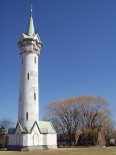
Fort Hill is a 0.4 square mile neighborhood and historic district of Roxbury, in Boston, Massachusetts. The approximate boundaries of Fort Hill are Malcolm X Boulevard on the north, Washington Street on the southeast, and Columbus Avenue on the southwest.


