
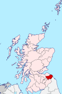
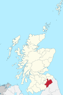
The Scottish Borders is one of 32 council areas of Scotland. It borders the City of Edinburgh, Dumfries and Galloway, East Lothian, Midlothian, South Lanarkshire, West Lothian and, to the south-west, south and east, the English counties of Cumbria and Northumberland. The administrative centre of the area is Newtown St Boswells.
Berwickshire is a historic county, registration county and lieutenancy area in southeastern Scotland, on the English border. It takes its name from Berwick-upon-Tweed, which was part of the Kingdom of Northumbria at the time of the county's formation, but became part of England in 1482 after several centuries of swapping back and forth between the two kingdoms.
Roxburghshire or the County of Roxburgh is a historic county and registration county in the Southern Uplands of Scotland. It borders Dumfriesshire to the west, Selkirkshire and Midlothian to the north-west, and Berwickshire to the north. To the south-west it borders Cumberland and to the south-east Northumberland, both in England.

Selkirkshire or the County of Selkirk is a historic county and registration county of Scotland. It borders Peeblesshire to the west, Midlothian to the north, Roxburghshire to the east, and Dumfriesshire to the south. It derives its name from its county town, the Royal burgh of Selkirk.
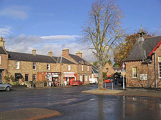
Newtown St Boswells is a village in the historic county of Roxburghshire which serves as the administrative centre of the Scottish Borders council area. Lying on the Bowden Burn, Newtown St Boswells is situated between the larger settlements of St Boswells to the south-east and Melrose to the north-west.

Coldingham is a village and parish in Berwickshire, Scottish Borders, on Scotland's southeast coastline, north of Eyemouth.
St Boswells is a village on the south side of the River Tweed in the Scottish Borders, about 1 mile southeast of Newtown St Boswells on the A68 road. It lies within the boundaries of the historic county of Roxburghshire.

Bemersyde House is a historic house in Roxburghshire, Scotland.
Maxton is a hamlet and civil parish in Roxburghshire, Scotland, and part of the Scottish Borders region.

Bemersyde is a hamlet in the Mertoun parish of Berwickshire, in the Scottish Borders. It sits on the left bank of the River Tweed, about three miles east of Melrose. Bemersyde House, the ancestral home of the Haig family, is the most notable feature.

Darnick is a village near Melrose in the Scottish Borders area of Scotland, in the former Roxburghshire. The name was first recorded in 1124, and has changed from Dernewic, Dernwick and Darnwick to the present Darnick. Darnick Tower was built in c. 1425, and another tower house, Fisher's Tower, is still recognisable by its remains.

Cavers is a parish in the Scottish Borders area of Scotland, in the former county of Roxburghshire, south and east of Hawick. The largest village in the parish is Denholm.

Clintmains is a village by the River Tweed, in the parish of Mertoun, to the east of Newtown St Boswells, in the Scottish Borders area of Scotland, in the former county of Berwickshire.
Scoonie is a settlement and parish in Fife, Scotland, the parish contains the town of Leven. It is bordered on the north by the parishes of Kettle and Ceres, on the east by the parish of Largo, on the south by the parishes of Markinch and Wemyss, and on the west by the parishes of Markinch and Kennoway. It extends about 4+1⁄2 miles north to south. Its width varies between 5⁄8 and 2+3⁄4 mi . The parish is on the coast of the Firth of Forth, with a coastline of about 1+1⁄2 mi (2.4 km) The area of the parish is 4,107 acres.
Makerstoun is a parish in the Scottish Borders area of Scotland, as well as the historic county of Roxburghshire, 4 miles (6 km) south-west of Kelso.
Channelkirk is a parish and community council area in the north-west corner of the historic county of Berwickshire in the Scottish Borders area of Scotland, forming the upper part of the ancient district of Lauderdale, while the parish of Lauder forms the lower part. The Community Council has the name Oxton and Channelkirk, Oxton being the main village of the parish. It was formerly in the Ettrick and Lauderdale district of Borders Region. A small strip of land along the northern boundary of the parish was added to Ettrick and Lauderdale district and thus also to the community council area, in the Brothershiels area, in 1988.
Nenthorn is a parish and hamlet in the south of the historic county of Berwickshire in the Scottish Borders area of Scotland. It is included in the Floors, Makerstoun, Nenthorn and Smailholm Community Council area, which also includes the parishes of Makerstoun and Smailholm. It was included in the former Roxburgh District of Borders Region, by the Local Government (Scotland) Act 1973, from 1975 to 1996.

Glencorse is a parish of Midlothian, Scotland, lying 7 miles south of Edinburgh. It is bounded on the north-west by the former parish of Colinton now within the City of Edinburgh, to the north and west by Lasswade and to the south and west by Penicuik.
Logie is a parish and village in east Fife, Scotland, 5 miles north-east of Cupar.


