Interstate 70 (I-70) is a major east–west Interstate Highway in the United States that runs from I-15 near Cove Fort, Utah, to I-695 and Maryland Route 570 (MD 570) in Woodlawn, just outside Baltimore, Maryland. I-70 approximately traces the path of U.S. Route 40 east of the Rocky Mountains. West of the Rocky Mountains, the route of I-70 was derived from multiple sources. The Interstate runs through or near many major cities, including Denver, Topeka, Kansas City, St. Louis, Indianapolis, Columbus, Pittsburgh, and Baltimore. The sections of the Interstate in Missouri and Kansas have laid claim to be the first Interstate in the United States. The Federal Highway Administration (FHWA) has claimed the section of I-70 through Glenwood Canyon in Colorado, completed in 1992, to be the last piece of the Interstate Highway System, as originally planned, to open to traffic. The construction of I-70 in Colorado and Utah is considered an engineering marvel, as the route passes through the Eisenhower Tunnel, Glenwood Canyon, and the San Rafael Swell. The Eisenhower Tunnel is the highest point along the Interstate Highway System, with an elevation of 11,158 feet (3,401 m).

Interstate 29 (I-29) is an Interstate Highway in the Midwestern United States. I-29 runs from Kansas City, Missouri, at a junction with I-35 and I-70, to the Canada–US border near Pembina, North Dakota, where it connects with Manitoba Provincial Trunk Highway 75 (PTH 75), which continues on to Winnipeg. The road follows the course of three major rivers, all of which form the borders of US states. The southern portion of I-29 closely parallels the Missouri River from Kansas City northward to Sioux City, Iowa, where it crosses and then parallels the Big Sioux River. For the northern third of the highway, it closely follows the Red River of the North. The major cities that I-29 connects to includes Council Bluffs, Iowa; Sioux City, Iowa; Sioux Falls, South Dakota; Fargo, North Dakota; and Grand Forks, North Dakota.

U.S. Route 400 is a 481.306-mile-long (774.587 km) mostly east–west U.S. Highway, commissioned in 1994. The highway's western terminus is in Granada, Colorado, at an intersection with US 385. The highway's eastern terminus is southwest of Joplin, Missouri, near Loma Linda, at an interchange with Interstate 44, with which it shares with US 166. It originally ended in Garden City, Kansas; in 1996 it was extended to its current western terminus.

U.S. Route 24 or U.S. Highway 24 (US 24) is one of the original United States Numbered Highways of 1926. It originally ran from Pontiac, Michigan, in the east to Kansas City, Missouri, in the west. Today, the highway's eastern terminus is in Independence Township, Michigan, at an intersection with Interstate 75 (I-75), and its western terminus is near Minturn, Colorado, at an intersection with I-70. The highway transitions from north–south to east–west signage at the Ohio–Michigan state line.

Interstate 435 (I-435) is an Interstate Highway beltway that encircles much of the Kansas City metropolitan area within the states of Kansas and Missouri in the United States.

U.S. Route 71 or U.S. Highway 71 is a major north–south United States highway that extends for over 1500 miles (2500 km) in the central United States. This original 1926 route has remained largely unchanged by encroaching Interstate highways. Currently, the highway's northern terminus is in International Falls, Minnesota at the Canada–US border, at the southern end of the Fort Frances-International Falls International Bridge to Fort Frances, Ontario. U.S. Route 53 also ends here. On the other side of the bridge, Trans-Canada Highway is an east–west route while Ontario Highway 71 is a north–south route. US 71's southern terminus is between Port Barre and Krotz Springs, Louisiana at an intersection with U.S. Route 190. For the entirety south of Kansas City, Missouri, US 71 runs parallel and concurrent with the existing and future Interstate 49. North of Kansas City, US 71 runs halfway between Interstate 29 and Interstate 35, which they split in the city at an interchange with Interstate 70.

U.S. Route 54 is an east–west United States Highway that runs northeast–southwest for 1,197 miles (1,926 km) from El Paso, Texas, to Griggsville, Illinois. The Union Pacific Railroad's Tucumcari Line runs parallel to US 54 from El Paso to Pratt, Kansas, which comprises about two-thirds of the route. Truckers refer to this road as "The Bee Line."

U.S. Route 73 is a north–south United States highway that runs for 113 miles (182 km) from northeast Kansas to southeast Nebraska. The highway's southern terminus is Bonner Springs, Kansas at I-70. Its northern terminus is near Dawson, Nebraska at US 75.

U.S. Route 169 is a north-south U.S highway that currently runs for 966 miles (1,555 km) from the city of Virginia, Minnesota, to Tulsa, Oklahoma, at Memorial Drive.
Route 152 is a state highway in the northern Kansas City metropolitan area. It begins at Interstate 435 south of the Kansas City International Airport and ends at Route 291 in Liberty. The route is a limited access highway between its two junctions with I-435. It crosses I-29 five miles (8.0 km) south of the airport in Platte County and US 169 in Clay County.

Interstate 635 (I-635) is a connector highway between I-35 in Overland Park, Kansas, and I-29 in Kansas City, Missouri, approximately 12 miles (19 km) long. It is mostly in the US state of Kansas, servicing the city of Kansas City, Kansas, but extends into Kansas City, Missouri, as well. The freeway's southern terminus is at a stack interchange with I-35. South of this, the mainline becomes an expressway carrying U.S. Route 69 (US 69).
K-32, also known as the Kaw Valley Scenic Highway, is an approximately 32.2-mile-long (51.8 km) east–west state highway in the Kansas City metropolitan area of Kansas. K-32's western terminus is just outside Lawrence at U.S. Route 24 (US-24) and US-40. Its eastern terminus is at US-69, also known as the 18th Street Expressway, in Kansas City. Along the way it intersects several major highways, including K-7 in Bonner Springs as well as Interstate 435 (I-435) and I-635 in Kansas City. In Kansas City, K-32 follows the Turner Diagonal from Kaw Drive to Kansas Avenue. From its western terminus to Bonner Springs, the highway is a two-lane rural highway; the remaining section is a four-lane highway that runs through residential areas.
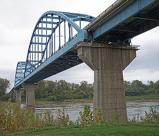
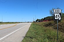
The Centennial Bridge is a through arch bridge road bridge over the Missouri River connecting Leavenworth, Kansas, and Platte County, Missouri. Constructed in 1955, it was initially a toll bridge. The bridge opened in 1955, a year after Leavenworth celebrated its centennial as the first city incorporated in Kansas. It is a two-span arch bridge connecting K-92 and Missouri Route 92. Its main span is 419.8 feet, and its total length is 2,571.2 feet. During the construction a spur of Route 45 called the "Leavenworth cutoff" was built to speed traffic to Kansas City, Missouri. The two-mile spur, even though it is in Missouri, was maintained by the city of Leavenworth until the tolls were removed from the Centennial Bridge in May 1977. The bridge is now maintained by the Kansas Department of Transportation.

K-5 is a 24-mile-long (39 km) state highway in northeastern Kansas. Remaining completely in the Kansas City metropolitan area, it connects Leavenworth to Kansas City.
Interstate 70 (I-70) in the US state of Missouri is generally parallel to the Missouri River. This section of the transcontinental Interstate begins at the Kansas state line on the Intercity Viaduct, running concurrently with US Route 24 (US 24), US 40, and US 169, and the east end is on the Stan Musial Veterans Memorial Bridge in St. Louis.

U.S. Route 50 (US 50) is a part of the U.S. Highway System that travels from West Sacramento, California, to Ocean City, Maryland. In the U.S. state of Colorado, US 50 is a major highway crossing through the lower midsection of the state. It connects the Western Slope with the lower Front Range and the Arkansas Valley. The highway serves the areas of Pueblo and Grand Junction as well as many other smaller areas along its corridor. The long-term project to widen the highway from two lanes to a four lane expressway between Grand Junction and Montrose was completed in January 2005. Only about 25% of the remainder of highway 50 in Colorado is four lane highway.
U.S. Route 50 (US 50) is a major east–west route in the state of Missouri. It is also known as the Rex M. Whitton Expressway in the capital of Missouri, Jefferson City.

Interstate 35 (I-35) is an Interstate Highway that stretches from Laredo, Texas, in the south to Duluth in the north. The portion of it through Missouri travels nearly 115 miles (185 km) from just south of Kansas City, through the Downtown Loop, and across the Missouri River before leaving the downtown area. North of Kansas City, the highway travels north-northeast toward the Iowa state line near Eagleville, paralleling U.S. Route 69 (US 69).

U.S. Route 63 is the portion of a north-south highway that runs through the U.S. state of Missouri from the Arkansas state line near Thayer to the Iowa state line near Lancaster.
K-92 is an approximately 44-mile-long (71 km) state highway in the U.S. state of Kansas. K-92's western terminus is at K-4 south of the community of Rock Creek, and the eastern terminus is a continuation as Missouri State Route 92 at the Missouri border by the City of Leavenworth. K-92 is co-designated as U.S. Route 59 (US-59) in Oskaloosa, K-16 from Oskaloosa to McLouth, and K-7 and US-73 in Leavenworth. The majority of the route passes through rural farmland and is almost entirely a two-lane roadway, except for the overlap with K-7 and US-73 and a portion of the US-59 overlap, which are four-lane.