
Chesterfield County is located just south of Richmond in the Commonwealth of Virginia. The county's borders are primarily defined by the James River to the north and the Appomattox River to the south. Its county seat is Chesterfield Court House.

Chester is a census-designated place (CDP) in Chesterfield County, Virginia, United States. Per the 2020 census, the population was 23,414.

Farmville is a town in Prince Edward and Cumberland counties in the Commonwealth of Virginia. The population was 7,473 at the 2020 census. It is the county seat of Prince Edward County.
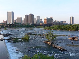
The Greater Richmond Region, the Richmond metropolitan area or Central Virginia, is a region and metropolitan area in the U.S. state of Virginia, centered on Richmond. The U.S. Office of Management and Budget (OMB) defines the area as the Richmond, VA Metropolitan Statistical Area, a Metropolitan Statistical Area (MSA) used by the U.S. Census Bureau and other entities. The OMB defines the area as comprising 17 county-level jurisdictions, including the independent cities of Richmond, Petersburg, Hopewell, and Colonial Heights. As of 2020, it had a population of 1,314,434, making it the 44th largest MSA in the country.
Midlothian is an unincorporated area and Census-designated place in Chesterfield County, Virginia, U.S. Settled as a coal town, Midlothian village experienced suburbanization effects and is now part of the western suburbs of Richmond, Virginia south of the James River in the Greater Richmond Region. Because of its unincorporated status, Midlothian has no formal government, and the name is used to represent the original small Village of Midlothian and a vast expanse of Chesterfield County in the northwest portion of Southside Richmond served by the Midlothian post office.
Norge is an unincorporated community in James City County, Virginia, United States.

The Southside of Richmond is an area of the Metropolitan Statistical Area surrounding Richmond, Virginia. It generally includes all portions of the City of Richmond that lie south of the James River, and includes all of the former city of Manchester. Depending on context, the term "Southside of Richmond" can include some northern areas of adjacent Chesterfield County, Virginia in the Richmond-Petersburg region. With minor exceptions near Bon Air, VA, the Chippenham Parkway forms the border between Chesterfield County and the City of Richmond portions of Southside, with some news agencies using the term "South Richmond" to refer to the locations in Southside located in the city proper.
The Richmond and Petersburg Railroad moved passengers and goods between Richmond and Petersburg from 1838 to 1898. It survived the American Civil War and eventually merged into the Atlantic Coast Line Railroad in 1900.

Ballsville is an unincorporated community in Powhatan County, Virginia. The community is located approximately forty miles due west of Richmond. It is on Virginia State Route 13 between Powhatan, Virginia and Cumberland, Virginia.
Skinquarter is an unincorporated town located off U.S. Route 360 in the western part of Chesterfield County in Virginia. It is located on the headwaters off Goode's Creek and Skinquarter Creek which flow to different places on the Appomattox River.
Chula is a mostly rural unincorporated community in the northeastern part of Amelia County just west of the Appomattox River in the U.S. state of Virginia. The town is centered around the T-intersection of SR 636 and SR 740 in Giles District. Chula is just west of SR 604, which includes a short bypass segment built around the town in the late 20th century. The area is served by the post office 7 miles southwest at Amelia Court House, ZIP code 23002. The nearest fire station to Chula is Amelia County Volunteer Fire Department Station 4, near Mattoax, 3 miles north.
Macon is an unincorporated community in Powhatan County, in the U.S. state of Virginia. Macon was a stop on the Farmville and Powhatan Railroad from 1884 to 1905 and then on the Tidewater and Western Railroad from 1905 to 1917. It is on the new Virginia State Route 13 between Powhatan, Virginia, and Cumberland, Virginia, from 1918 to today.
Tobaccoville is an unincorporated rural hamlet in Powhatan County, Virginia. Tobaccoville was a stop on the Farmville and Powhatan Railroad from 1884 to 1905 and then on the Tidewater and Western Railroad from 1905 to 1917. A magazine notice for renting the "Indian Camp" farm advertised that the farm was near the Tobaccoville station of the Tidewater and Western Railroad. This would help the tenant farmer get dairy products to market. Since 1918, Tobaccoville is on Virginia State Route 13 at the T-intersection with Clement Town Road, between Powhatan, Virginia and Cumberland, Virginia. It consists of a convenience store with gasoline pumps and a volunteer fire department station, along with several houses and farmland.
Raines Tavern is an unincorporated community in Cumberland County on Virginia State Route 45 just north of Farmville, Virginia, in the U.S. state of Virginia. It was a stop on the Farmville and Powhatan Railroad from 1884 to 1905, and on the Tidewater and Western Railroad from 1905 to 1917.
Sunny Side is an unincorporated community in Buckingham and Cumberland counties, in the U.S. state of Virginia. Sunny Side was a stop on the Farmville and Powhatan Railroad from 1884 to 1905 and then on the Tidewater and Western Railroad from 1905 to 1917. It is on the new Virginia State Route 13 between Powhatan, Virginia and Cumberland, Virginia from 1918 to today.

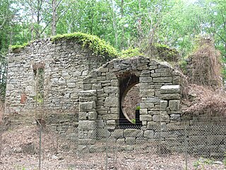
Beach Station a national historic district located near Chesterfield, in Chesterfield County, Virginia. The district includes six contributing buildings and one contributing site in the Village of Beach. They were all constructed about 1890 and are two single-family dwellings, a post office, a railway depot, an outbuilding, two railroad shanties, and the ruins of the former general store. Beach Station was accessible from the Farmville and Powhatan Railroad later named the Tidewater and Western Railroad. Leasing arrangements had been made with the Brighthope Railway company which was sold to become the Farmville and Powhatan. The district represents an unusual collection of late-nineteenth-century buildings in their historic surroundings. It was listed on the National Register of Historic Places in 2008.

In 1886, Randolph Harrison, of the Virginia department of Agriculture, cited Cumberland Mining Company, stating that the United States had purchased stock in the Brighthope Railway. He continued by citing their assertion that extending the railway into Cumberland would increase the value of farms there because they could sell consumer agricultural products such as fruit, dairy and vegetables to all markets of Virginia. The Brighthope Railway was founded in 1877 by the creditors of the Clover Hill Railroad who bought that railroad when the Clover Hill Railroad went bankrupt. The Brighthope Railway continued in the role of the Clover Hill Railroad, hauling coal from the Clover Hill Pits at Winterpock, Virginia. In addition to coal, the Bright Hope Railway transported timber and agricultural products and had passenger service. The Bright Hope Railway was narrowed from standard gauge to narrow gauge and rerouted in 1881. In 1886, much of the southern rails were changed to standard gauge. The Brighthope Railway was not changed back.
In 1886, Randolph Harrison, of the Virginia department of Agriculture, cited Cumberland Mining Company, stating that businessmen would soon open a hotel at Lithia Springs, Farmville, VA for people seeking the healing waters. The Brighthope railway would be extended to bring them there. But instead, the Farmville and Powhatan Railroad Company built the narrow gauge rails through Cumberland County and the Farmville and Powhatan Railroad Company bought the Brighthope Railway, so the Farmville and Powhatan Railroad made the connection. In 1890, Beach Station was built with a railroad depot, some railroad shanties, a general store and an owner's house, the George Perdue House as a stop on the line.

The Swift Creek Rail Bridge was a granite and iron truss bridge over Swift Creek in Virginia. The Tidewater and Western Railroad included a bridge over Swift Creek that had been built by an earlier railroad company, the Clover Hill Railroad. The bridge was used during the whole time the four railroad companies operated rails over the bridge. The metal on the bridge was sold as part of foreclosure of the final company in 1917.

The Farmville and Powhatan Railroad went bankrupt in 1905 and became the Tidewater and Western Railroad. The line survived until 1917 when it was pulled up and sent to France for the World War I effort. The Tidewater and Western Railroad carried freight and passengers along a route from Farmville, Virginia to Bermuda Hundred. The Tidewater and Western Railroad continued to have Western Union Telegraphs run along the rails. These connected to telegraphs on the Atlantic Coast Line along the East Coast of the US and to Europe.


