
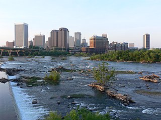
Richmond is the capital city of the Commonwealth of Virginia in the United States. Incorporated in 1742, Richmond has been an independent city since 1871. The city's population in the 2020 census was 226,610, up from 204,214 in 2010, making it Virginia's fourth-most populous city. The Richmond metropolitan area, with over 1.3 million residents, is the Commonwealth's third-most populous.

Petersburg is an independent city in the Commonwealth of Virginia in the United States. As of the 2020 census, the population was 33,458 with a majority black American. The Bureau of Economic Analysis combines Petersburg with Dinwiddie County for statistical purposes. The city is 21 miles (34 km) south of the commonwealth (state) capital city of Richmond.

Henrico County, officially the County of Henrico, is located in the Commonwealth of Virginia in the United States. As of the 2020 census, the population was 334,389 making it the fifth-most populous county in Virginia. Henrico County is included in the Greater Richmond Region. There is no incorporated community within Henrico County; therefore, there is no incorporated county seat either. Laurel, an unincorporated CDP, serves this function.

Colonial Heights is an independent city in the Commonwealth of Virginia. As of the 2020 census, the population was 18,170. The Bureau of Economic Analysis combines the City of Colonial Heights with Dinwiddie County for statistical purposes.

Chesterfield County is located just south of Richmond in the Commonwealth of Virginia. The county's borders are primarily defined by the James River to the north and the Appomattox River to the south. Its county seat is Chesterfield Court House.

Bon Air is a census-designated place (CDP) in Chesterfield County, Virginia, United States. The population was 18,022 at the 2020 census. The community is considered a suburb of the independent city of Richmond in the Richmond-Petersburg region and is a part of the Southside neighborhoods. Originally developed as a resort, a central portion of Bon Air has been designated as a National Historic District with many structures of Victorian design from the late 19th and early 20th centuries. Its name means "good air," reflecting its role as a resort getaway that wealthy Richmonders enjoyed for its fresh air as opposed to the dirty air of Richmond's industrial downtown of the late 19th century.

Chester is a census-designated place (CDP) in Chesterfield County, Virginia, United States. Per the 2020 census, the population was 23,414.

Woodbridge is a census-designated place (CDP) in Prince William County, Virginia, United States, located 20 miles (32 km) south of Washington, D.C. Bounded by the Occoquan and Potomac rivers, Woodbridge had 44,668 residents at the 2020 census.
The Greater Richmond Region, the Richmond metropolitan area or Central Virginia, is a region and metropolitan area in the U.S. state of Virginia, centered on Richmond. The U.S. Office of Management and Budget (OMB) defines the area as the Richmond, VA Metropolitan Statistical Area, a Metropolitan Statistical Area (MSA) used by the U.S. Census Bureau and other entities. The OMB defines the area as comprising 17 county-level jurisdictions, including the independent cities of Richmond, Petersburg, Hopewell, and Colonial Heights. As of 2020, it had a population of 1,314,434, making it the 44th largest MSA in the country.
Midlothian is an unincorporated area and Census-designated place in Chesterfield County, Virginia, U.S. Settled as a coal town, Midlothian village experienced suburbanization effects and is now part of the western suburbs of Richmond, Virginia south of the James River in the Greater Richmond Region. Because of its unincorporated status, Midlothian has no formal government, and the name is used to represent the original small Village of Midlothian and a vast expanse of Chesterfield County in the northwest portion of Southside Richmond served by the Midlothian post office.

Ashburn is a rapidly growing census-designated place (CDP) in Loudoun County, Virginia, United States. At the 2010 United States census, its population was 43,511, up from 3,393 in 1990. It is 30 miles (48 km) northwest of Washington, D.C., and part of the Washington metropolitan area.

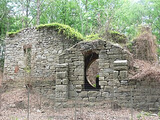
Sir Thomas Dale was an English naval commander who served as deputy-governor of the Virginia Colony in 1611 and again from 1614 to 1616. Dale is best remembered for the energy and the extreme rigour of his administration in Virginia, which established order and in various ways seems to have benefited the colony, although he was criticised for high-handedness. He is also credited with the establishment of Bermuda Hundred, Bermuda Cittie, and the Cittie of Henricus.
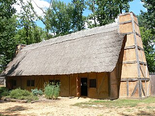
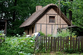
The "Citie of Henricus"—also known as Henricopolis, Henrico Town or Henrico—was a settlement in Virginia founded by Sir Thomas Dale in 1611 as an alternative to the swampy and dangerous area around the original English settlement at Jamestown, Virginia. It was named for Henry, Prince of Wales (1594–1612), the eldest son of King James I.
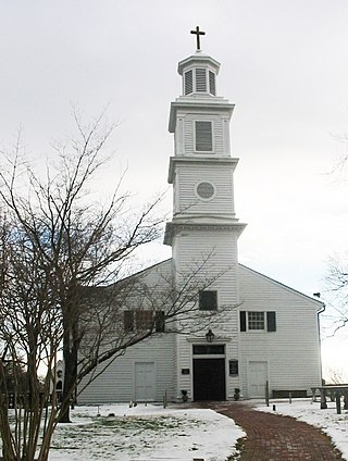
St. John's Church is an Episcopal church located at 2401 East Broad Street in Richmond, Virginia, United States. Formed from several earlier parishes, St. John's is the oldest church in the city of Richmond, Virginia. It was built in 1741 by William Randolph's son, Colonel Richard Randolph; the Church Hill district was named for it. It was the site of two important conventions in the period leading to the American Revolutionary War, and is famous as the location where American Founding Father Patrick Henry gave his memorable speech at the Second Virginia Convention, closing with the often-quoted demand, "Give me liberty, or give me death!" The church is designated as a National Historic Landmark.

Chesterfield County Public Schools is the public school system of Chesterfield County, Virginia, United States. As of 2020, there are about 64,000 students enrolled in 66 schools. There are 40 elementary schools, 12 middle schools, and 10 high schools. Additionally, high school students can enroll in 13 specialty centers, two technical centers, one career academy, and two Governor's Schools.

The Tri-Cities of Virginia is an area in the Greater Richmond Region which includes the three independent cities of Petersburg, Colonial Heights, and Hopewell and portions of the adjoining counties of Chesterfield, Dinwiddie, and Prince George in south-central Virginia. Other unincorporated communities located in the Tri-Cities area include Ettrick, Fort Gregg-Adams, and City Point, the latter formerly a historic incorporated town which was annexed to become part of the City of Hopewell.

Cascades is a census-designated place (CDP) in Loudoun County, Virginia, United States. The population as of the 2010 United States Census was 11,912. Along with nearby Countryside and Lowes Island, it is considered one of the three main components of the Potomac Falls community within Sterling, Virginia.
Farrar's Island is a peninsula on the west side of the James River in Chesterfield County, Virginia. It is the site of the Dutch Gap Conservation Area and Boat Landing and the Henricus Historical Park. Originally, Farrar's Island was formed by a meander loop in the James River and lay on the east side of the James River. At its smallest point, the neck of the peninsula was less than 400 feet wide. At that time, Farrar's Island was slightly less than 700 acres and lay about 15 miles (24 km) south of the James River fall line at Richmond, Virginia.

Steiner Ranch is a planned community and census-designated place (CDP) in Travis County, Texas, United States. It was first listed as a CDP in the 2020 census.


