Newberry, Indiana

Last updated

Newberry, Indiana
Newberry, Indiana.jpg
Greene County Indiana Incorporated and Unincorporated areas Newberry Highlighted 1852524.svg
Location of Newberry in Greene County, Indiana.
Coordinates: 38°55′26″N87°01′10″W / 38.92389°N 87.01944°W / 38.92389; -87.01944
Country United States
State Indiana
County Greene
Township Cass
Area
[1]
  Total0.48 sq mi (1.24 km2)
  Land0.48 sq mi (1.24 km2)
  Water0.00 sq mi (0.00 km2)
Elevation
[2]
558 ft (170 m)
Population
 (2020)
  Total159
  Density331.94/sq mi (128.07/km2)
Time zone UTC-5 (Eastern (EST))
  Summer (DST) UTC-4 (EDT)
ZIP code
47449
Area code 812
FIPS code 18-52524 [3]
GNIS feature ID2396811 [2]

Newberry is a town in Cass Township, Greene County, Indiana, United States. The population was 193 at the 2010 census. It is part of the Bloomington, Indiana Metropolitan Statistical Area.

Contents

Geography

According to the 2010 census, Newberry has a total area of 0.49 square miles (1.27 km2), all land. [4]

Climate

The climate in this area is characterized by hot, humid summers and generally mild to cool winters. According to the Köppen Climate Classification system, Newberry has a humid subtropical climate, abbreviated "Cfa" on climate maps. [5]

Demographics

Historical population
CensusPop.Note
1880 329
1910 455
1920 439−3.5%
1930 306−30.3%
1940 36017.6%
1950 340−5.6%
1960 256−24.7%
1970 29515.2%
1980 246−16.6%
1990 207−15.9%
2000 206−0.5%
2010 193−6.3%
2020 159−17.6%
U.S. Decennial Census [6]

2010 census

As of the census [7] of 2010, there were 193 people, 81 households, and 51 families living in the town. The population density was 393.9 inhabitants per square mile (152.1/km2). There were 93 housing units at an average density of 189.8 per square mile (73.3/km2). The racial makeup of the town was 97.9% White, 1.0% Native American, 0.5% Pacific Islander, and 0.5% from other races. Hispanic or Latino of any race were 2.6% of the population.

There were 81 households, of which 24.7% had children under the age of 18 living with them, 53.1% were married couples living together, 3.7% had a female householder with no husband present, 6.2% had a male householder with no wife present, and 37.0% were non-families. 32.1% of all households were made up of individuals, and 8.6% had someone living alone who was 65 years of age or older. The average household size was 2.38 and the average family size was 2.96.

The median age in the town was 47.8 years. 20.7% of residents were under the age of 18; 4.6% were between the ages of 18 and 24; 22.2% were from 25 to 44; 34.8% were from 45 to 64; and 17.6% were 65 years of age or older. The gender makeup of the town was 49.2% male and 50.8% female.

2000 census

As of the census [3] of 2000, there were 206 people, 93 households, and 59 families living in the town. The population density was 420.9 inhabitants per square mile (162.5/km2). There were 104 housing units at an average density of 212.5 per square mile (82.0/km2). The racial makeup of the town was 98.54% White, 0.49% African American, and 0.97% from two or more races. Hispanic or Latino of any race were 0.49% of the population.

There were 93 households, out of which 30.1% had children under the age of 18 living with them, 52.7% were married couples living together, 6.5% had a female householder with no husband present, and 35.5% were non-families. 35.5% of all households were made up of individuals, and 19.4% had someone living alone who was 65 years of age or older. The average household size was 2.22 and the average family size was 2.82.

In the town, the population was spread out, with 21.4% under the age of 18, 7.3% from 18 to 24, 25.2% from 25 to 44, 30.1% from 45 to 64, and 16.0% who were 65 years of age or older. The median age was 42 years. For every 100 females, there were 98.1 males. For every 100 females age 18 and over, there were 88.4 males.

The median income for a household in the town was $36,964, and the median income for a family was $45,833. Males had a median income of $32,321 versus $22,031 for females. The per capita income for the town was $18,313. About 6.3% of families and 12.9% of the population were below the poverty line, including 10.3% of those under the age of eighteen and 25.9% of those 65 or over.

Related Research Articles

<span class="mw-page-title-main">Jonesville, Indiana</span> Town in Indiana, United States

Jonesville is a town in Wayne Township, Bartholomew County, in the U.S. state of Indiana. The population was 177 at the 2010 census. It is part of the Columbus, Indiana metropolitan statistical area.

<span class="mw-page-title-main">Milltown, Indiana</span> Town in Indiana, United States

Milltown is a town in Whiskey Run Township in Crawford County, Indiana and in Blue River and Spencer townships in Harrison County. The population was 818 at the time of the 2010 census.

<span class="mw-page-title-main">Dillsboro, Indiana</span> Town in Indiana, United States

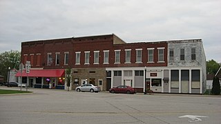
Dillsboro is a town in Clay Township, Dearborn County, Indiana, United States. As of 2020, the population is 1,360.

<span class="mw-page-title-main">Jasonville, Indiana</span> City in Indiana, United States

Jasonville is a city in Greene County, Indiana, United States. The population was 1,966 as of the 2020 census. It is the westernmost community in the Bloomington, Indiana, Metropolitan Statistical Area, approximately 15 miles closer to Terre Haute than to Bloomington.

<span class="mw-page-title-main">Lyons, Indiana</span> Town in Indiana, United States

Lyons is a town in Washington Township, Greene County, Indiana, United States. The population was 742 at the 2010 census. It is part of the Bloomington, Indiana Metropolitan Statistical Area.

<span class="mw-page-title-main">Switz City, Indiana</span> Town in Indiana, United States

Switz City is a town in Fairplay and Grant townships, Greene County, Indiana, United States. The population was 293 at the 2010 census. It is part of the Bloomington, Indiana, Metropolitan Statistical Area.

<span class="mw-page-title-main">Worthington, Indiana</span> Town in Indiana, United States

Worthington is a town in Jefferson Township, Greene County, Indiana, United States. The population was 1,463 at the 2010 United States Census. It is part of the Bloomington, Indiana, Metropolitan Statistical Area.

<span class="mw-page-title-main">New Whiteland, Indiana</span> Town in Indiana, United States

New Whiteland is a town in Pleasant Township, Johnson County, Indiana, United States. The population was 5,550 at the 2020 census.

<span class="mw-page-title-main">Whiteland, Indiana</span> Town in Indiana, United States

Whiteland is a town in Pleasant, Franklin and Clark townships, Johnson County, Indiana, United States. The population was 4,599 at the 2020 census.

<span class="mw-page-title-main">Bicknell, Indiana</span> City in Indiana, United States

Bicknell is a city in Knox County, Indiana, United States. The population was 2,915 at the 2010 census.

<span class="mw-page-title-main">Bruceville, Indiana</span> Town in Indiana, United States

Bruceville is a town in Washington Township, Knox County, Indiana, United States. The population was 478 at the 2010 census.

<span class="mw-page-title-main">Sandborn, Indiana</span> Town in Indiana, United States

Sandborn is a town in Vigo Township, Knox County, Indiana, United States. The population was 359 at the 2020 census. It is the home of the annual Black Creek Festival.

<span class="mw-page-title-main">Crane, Indiana</span> Town in Indiana, United States

Crane is a town in Perry Township, Martin County, in the U.S. state of Indiana. The population was 166 at the 2020 census. The community is adjacent to the Naval Surface Warfare Center Crane Division.

<span class="mw-page-title-main">Paoli, Indiana</span> Town in Indiana, United States

Paoli is a town within Paoli Township and the county seat of Orange County, in the U.S. state of Indiana. The population was 3,677 at the 2010 census.

<span class="mw-page-title-main">Rockville, Indiana</span> Town in Indiana, United States

Rockville is a town in Adams Township, Parke County, in the U.S. state of Indiana. The population was 2,607 at the 2010 census. The town is the county seat of Parke County. It is known as "The Covered Bridge Capital of the World".

<span class="mw-page-title-main">Winslow, Indiana</span> Town in Indiana, United States

Winslow is a town in Patoka Township, Pike County, in the U.S. state of Indiana. The population was 864 at the 2010 census. It is part of the Jasper Micropolitan Statistical Area.

<span class="mw-page-title-main">Poseyville, Indiana</span> Town in Indiana, United States

Poseyville is a town in Robb Township, Posey County, in the U.S. state of Indiana. The population was 1,045 at the 2010 census.

<span class="mw-page-title-main">Sunman, Indiana</span> Town in Indiana, United States

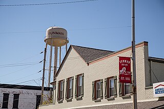
Sunman is a town in Adams Township, Ripley County, in the U.S. state of Indiana. The population was 1,049 at the 2010 census.

<span class="mw-page-title-main">Fairview Park, Indiana</span> Town in Indiana, United States

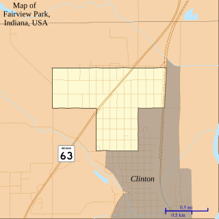
Fairview Park is a town in Clinton Township, Vermillion County, in the U.S. state of Indiana. The population was 1,386 at the 2010 census.

<span class="mw-page-title-main">Seelyville, Indiana</span> Town in Indiana, United States

Seelyville is a town in Lost Creek Township, Vigo County, in the U.S. state of Indiana. The population was 1,029 at the 2010 census. It is part of the Terre Haute Metropolitan Statistical Area.

References

  1. "2020 U.S. Gazetteer Files". United States Census Bureau. Retrieved March 16, 2022.
  2. 1 2 U.S. Geological Survey Geographic Names Information System: Newberry, Indiana
  3. 1 2 "U.S. Census website". United States Census Bureau . Retrieved January 31, 2008.
  4. "G001 - Geographic Identifiers - 2010 Census Summary File 1". United States Census Bureau. Archived from the original on February 13, 2020. Retrieved July 17, 2015.
  5. Climate Summary for Newberry, Indiana
  6. "Census of Population and Housing". Census.gov. Retrieved June 4, 2015.
  7. "U.S. Census website". United States Census Bureau . Retrieved December 11, 2012.