Worthington, Indiana

Last updated

Worthington, Indiana
Commercial south of First, Worthington.jpg
Downtown Worthington
Greene County Indiana Incorporated and Unincorporated areas Worthington Highlighted 1885598.svg
Location of Worthington in Greene County, Indiana.
Coordinates: 39°07′15″N86°58′52″W / 39.12083°N 86.98111°W / 39.12083; -86.98111
Country United States
State Indiana
County Greene
Township Jefferson
Area
[1]
  Total0.77 sq mi (2.00 km2)
  Land0.77 sq mi (2.00 km2)
  Water0.00 sq mi (0.00 km2)
Elevation
[2]
518 ft (158 m)
Population
 (2020)
  Total1,393
  Density1,804.40/sq mi (696.44/km2)
Time zone UTC-5 (Eastern (EST))
  Summer (DST) UTC-4 (EDT)
ZIP code
47471
Area code 812
FIPS code 18-85598 [3]
GNIS feature ID2397756 [2]

Worthington is a town in Jefferson Township, Greene County, Indiana, United States. The population was 1,463 at the 2010 United States Census. It is part of the Bloomington, Indiana, Metropolitan Statistical Area.

Contents

Worthington, Indiana Worthington, Indiana.jpg
Worthington, Indiana
Worthington, Indiana fountain Worthington, Indiana fountain.jpg
Worthington, Indiana fountain

History

The Worthington post office was established in 1850. [4] The town was named after Worthington, Ohio. [5]

Geography

According to the 2010 census, Worthington has a total area of 0.81 square miles (2.10 km2), all land. [6]

Demographics

Historical population
CensusPop.Note
1880 1,185
1890 1,44822.2%
1900 1,4480.0%
1910 1,73219.6%
1920 1,8537.0%
1930 1,687−9.0%
1940 1,7292.5%
1950 1,627−5.9%
1960 1,6350.5%
1970 1,6913.4%
1980 1,574−6.9%
1990 1,473−6.4%
2000 1,4810.5%
2010 1,463−1.2%
2020 1,393−4.8%
Source: US Census Bureau

2010 census

As of the 2010 United States Census, there were 1,463 people, 625 households, and 400 families in the town. The population density was 1,806.2 inhabitants per square mile (697.4/km2). There were 716 housing units at an average density of 884.0 per square mile (341.3/km2). The racial makeup of the town was 98.5% White, 0.1% African American, 0.3% Native American, 0.1% Asian, 0.5% from other races, and 0.5% from two or more races. Hispanic or Latino of any race were 1.4% of the population.

There were 625 households, of which 32.5% had children under the age of 18 living with them, 48.2% were married couples living together, 11.7% had a female householder with no husband present, 4.2% had a male householder with no wife present, and 36.0% were non-families. 31.8% of all households were made up of individuals, and 15.7% had someone living alone who was 65 years of age or older. The average household size was 2.34 and the average family size was 2.93.

The median age in the town was 39 years. 24.1% of residents were under the age of 18; 8.7% were between the ages of 18 and 24; 24% were from 25 to 44; 25.1% were from 45 to 64; and 18.1% were 65 years of age or older. The gender makeup of the town was 47.8% male and 52.2% female.

2000 census

As of the 2000 United States Census, there were 1,481 people, 644 households, and 410 families in the town. The population density was 1,834.4 people per square mile (708.3 people/km2). There were 726 housing units at an average density of 899.2 per square mile (347.2/km2). The racial makeup of the town was 98.58% White, 0.07% African American, 0.27% Native American, 0.07% Asian, and 1.01% from two or more races. Hispanic or Latino of any race were 0.41% of the population.

There were 644 households, out of which 26.4% had children under the age of 18 living with them, 50.3% were married couples living together, 9.9% had a female householder with no husband present, and 36.2% were non-families. 31.8% of all households were made up of individuals, and 18.8% had someone living alone who was 65 years of age or older. The average household size was 2.29 and the average family size was 2.82.

The town population contained 23.6% under the age of 18, 7.4% from 18 to 24, 26.1% from 25 to 44, 22.7% from 45 to 64, and 20.2% who were 65 years of age or older. The median age was 40 years. For every 100 females, there were 87.0 males. For every 100 females age 18 and over, there were 82.7 males.

The median income for a household in the town was $27,778, and the median income for a family was $37,604. Men had a median income of $29,219 versus $21,792 for women. The per capita income for the town was $18,761. About 9.2% of families and 13.0% of the population were below the poverty line, including 15.0% of those under age 18 and 8.4% of those age 65 or over.

Education

The town has a lending library, the Worthington-Jefferson Township Public Library. [7]

Related Research Articles

<span class="mw-page-title-main">Milltown, Indiana</span> Town in Indiana, United States

Milltown is a town in Whiskey Run Township in Crawford County, Indiana and in Blue River and Spencer townships in Harrison County. The population was 818 at the time of the 2010 census.

<span class="mw-page-title-main">St. Leon, Indiana</span> Town in Indiana, United States

St. Leon or Saint Leon is a town in Kelso Township, Dearborn County, Indiana, United States. The population was 678 at the 2010 census.

<span class="mw-page-title-main">St. Paul, Indiana</span> Town in Indiana, United States

St. Paul or Saint Paul is a small town on the border of Decatur and Shelby counties in the U.S. state of Indiana. The population was 1,031 at the 2010 census.

<span class="mw-page-title-main">Ashley, Indiana</span> Town in Indiana, United States

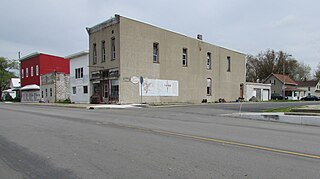
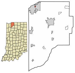
Ashley is a town in Indiana located on the border of Smithfield Township, DeKalb County and Steuben Township, Steuben County. The population was 983 at the 2010 census.

<span class="mw-page-title-main">Jasonville, Indiana</span> City in Indiana, United States

Jasonville is a city in Greene County, Indiana, United States. The population was 1,966 as of the 2020 census. It is the westernmost community in the Bloomington, Indiana, Metropolitan Statistical Area, approximately 15 miles closer to Terre Haute than to Bloomington.

<span class="mw-page-title-main">Lyons, Indiana</span> Town in Indiana, United States

Lyons is a town in Washington Township, Greene County, Indiana, United States. The population was 742 at the 2010 census. It is part of the Bloomington, Indiana Metropolitan Statistical Area.

<span class="mw-page-title-main">Newberry, Indiana</span> Town in Indiana, United States

Newberry is a town in Cass Township, Greene County, Indiana, United States. The population was 193 at the 2010 census. It is part of the Bloomington, Indiana Metropolitan Statistical Area.

<span class="mw-page-title-main">Switz City, Indiana</span> Town in Indiana, United States

Switz City is a town in Fairplay and Grant townships, Greene County, Indiana, United States. The population was 293 at the 2010 census. It is part of the Bloomington, Indiana, Metropolitan Statistical Area.

<span class="mw-page-title-main">Wilkinson, Indiana</span> Town in Indiana, United States

Wilkinson is a town in Brown Township, Hancock County, Indiana, United States. The population was 449 at the 2010 census.

<span class="mw-page-title-main">Andrews, Indiana</span> Town in Indiana, United States

Andrews is a town in Dallas Township, Huntington County, Indiana, United States. The population was 1,048 at the 2020 census.

<span class="mw-page-title-main">Sandborn, Indiana</span> Town in Indiana, United States

Sandborn is a town in Vigo Township, Knox County, Indiana, United States. The population was 359 at the 2020 census. It is the home of the annual Black Creek Festival.

<span class="mw-page-title-main">Sidney, Indiana</span> Town in Indiana, United States

Sidney is a town in Jackson Township, Kosciusko County, in the U.S. state of Indiana. The population was 83 at the 2010 census.

<span class="mw-page-title-main">Kingsbury, Indiana</span> Town in Indiana, United States

Kingsbury is a town in Washington Township, LaPorte County, Indiana, just northwest of the intersection of U.S. Route 35 and U.S. Route 6. The town was founded in 1835 and incorporated on March 3, 1941. During 1940 - 1941, the Kingsbury Ordnance Plant (KOP) was built for use during World War II. The plant closed after the war but reopened during the Korean War, closing permanently in 1959. The population was 242 at the 2010 census. It is included in the Michigan City, Indiana-La Porte, Indiana Metropolitan Statistical Area. The town has its own fire department, KVFD, and a Greek revival style First Baptist church built in 1851 with its own graveyard and Winchell Cemetery.

<span class="mw-page-title-main">Pottawattamie Park, Indiana</span> Town in Indiana, United States

Pottawattamie Park is a town in Michigan Township, LaPorte County, Indiana, United States. The population was 235 at the 2010 census. It is included in the Michigan City, Indiana-La Porte, Indiana Metropolitan Statistical Area.

<span class="mw-page-title-main">Edgewood, Indiana</span> Town in Indiana, United States

Edgewood is a town in Anderson Township, Madison County, Indiana, United States. It is part of the Indianapolis–Carmel–Anderson metropolitan statistical area. The population was 2,053 at the 2020 census.

<span class="mw-page-title-main">Fillmore, Indiana</span> Town in Indiana, United States

Fillmore is a town in Marion Township, Putnam County, in the U.S. state of Indiana. The population was 532 at the 2020 census.

<span class="mw-page-title-main">Hudson, Indiana</span> Town in Indiana, United States

Hudson is a town in Salem and Steuben townships, Steuben County, in the U.S. state of Indiana. The population was 518 at the 2010 census.

<span class="mw-page-title-main">Poneto, Indiana</span> Town in Indiana, United States

Poneto is a town in Chester, Harrison and Liberty townships, Wells County, in the U.S. state of Indiana. The population was 166 at the 2010 census.

<span class="mw-page-title-main">Riverlea, Ohio</span> Village in Ohio, United States

Riverlea is a village in Franklin County, Ohio, United States, surrounded by Worthington on its north, south, and east sides, and bordered on the west by the Olentangy River, across which is Columbus. Riverlea was incorporated in 1939, a small community that formed on former farmland. The population was 599 at the 2020 census.

<span class="mw-page-title-main">Worthington, West Virginia</span> Town in West Virginia, United States

Worthington is a town in Marion County, West Virginia, United States. The population was 158 at the 2010 census. Worthington was incorporated in 1893 and named for Colonel George Worthington, an early settler. U.S. Route 19 passes through the town.

References

  1. "2020 U.S. Gazetteer Files". United States Census Bureau. Retrieved March 16, 2022.
  2. 1 2 U.S. Geological Survey Geographic Names Information System: Worthington, Indiana
  3. "US Census website". US Census Bureau. Retrieved January 31, 2008.
  4. "Greene County". Jim Forte Postal History. Retrieved September 3, 2014.
  5. Baker, Ronald L. (October 1995). From Needmore to Prosperity: Hoosier Place Names in Folklore and History . Indiana University Press. p.  353. ISBN   978-0-253-32866-3. ...named for Worthington, Ohio...
  6. "Geographic Identifiers - 2010 Census Summary File 1". US Census Bureau. Archived from the original on February 13, 2020. Retrieved July 25, 2015.
  7. "Indiana public library directory" (PDF). Indiana State Library. Retrieved March 7, 2018.