North Amherst, Massachusetts

Last updated

North Amherst
North Amherst Fire Station.jpg
North Amherst Fire Station
USA Massachusetts location map.svg
Red pog.svg
North Amherst
Usa edcp location map.svg
Red pog.svg
North Amherst
Coordinates: 42°24′22″N72°31′16″W / 42.40611°N 72.52111°W / 42.40611; -72.52111
Country United States
State Massachusetts
County Hampshire
Town Amherst
Area
  Total2.1 sq mi (5.5 km2)
  Land2.1 sq mi (5.5 km2)
  Water0.0 sq mi (0.0 km2)
Elevation
187 ft (57 m)
Population
 (2010)
  Total6,819
  Density3,202/sq mi (1,236.4/km2)
Time zone UTC-5 (Eastern (EST))
  Summer (DST) UTC-4 (EDT)
ZIP code
01059
Area code 413
FIPS code 25-46295
GNIS feature ID0608905

North Amherst is a census-designated place (CDP) in the city of Amherst in Hampshire County, Massachusetts, United States. The population was 6,819 at the 2010 census, [1] up from 6,019 at the 2000 census. It is part of the Springfield, Massachusetts Metropolitan Statistical Area.

Contents

Geography

North Amherst is located in the northern part of the city of Amherst at 42°24′22″N72°31′16″W / 42.40611°N 72.52111°W / 42.40611; -72.52111 (42.406192, -72.521217). [2] It is bordered to the south by the Amherst Center CDP and to the southwest by the town of Hadley. The CDP border follows the Mill River north from the Hadley town line, then east across Massachusetts Route 116 as far as Massachusetts Route 63. The border then follows Pulpit Hill Road, Mill Street, Sand Hill Road, and Pine Street east to the New England Central Railroad line, which it follows south to Tilson Farm Road. The CDP boundary then proceeds west along Tilson Farm Road and Eastman Lane to North Pleasant Street, which it follows north to a brook near the Hadley town line. [3]

According to the United States Census Bureau, the CDP has a total area of 2.1 square miles (5.5 km2), of which 1.0 acre (3,930 m2), or 0.07%, are water. [1]

There are several large apartment complexes in North Amherst, housing mostly students of the University of Massachusetts Amherst along with low-income families (a plurality of whom are graduate students). Apart from these housing developments, North Amherst also sports many beautiful old houses, and North Amherst Center Historic District is on the National Register of Historic Places. The village is said[ who? ] to be an excellently-preserved example of a 19th-century farm community.

North Amherst is home to a large majority of Amherst middle income families, as the main street (North Pleasant Street) has many housing developments built off it. This includes "Grantwood", which is the largest neighborhood/development in Amherst.[ citation needed ] North Amherst is also home to two cohousing communities: Pioneer Valley and Pine Street Cohousing.

Cushman Village is located just east of North Amherst. This small area is unique, as the roads turn back into each other unlike the square roads off East Pleasant Street. Cushman Village has many historical homes, as well as the Cushman Common and the Cushman Store.

North Amhearst is also known for its amphibian tunnels. The Henry Street salamander tunnels are tunnels which run under Henry Street in North Amherst. The tunnels help spotted salamanders cross Henry Street to get to vernal pools that the salamanders use for breeding. They are the first amphibian tunnels in the United States. [4]

Demographics

As of the census [5] of 2000, there were 6,019 people, 1,915 households, and 813 families residing in the CDP. The population density was 1,101.4/km2 (2,856.1/mi2). There were 1,947 housing units at an average density of 356.3/km2 (923.9/mi2). The racial makeup of the CDP was 75.76% White, 4.44% African American, 0.25% Native American, 13.09% Asian, 0.22% Pacific Islander, 3.11% from other races, and 3.14% from two or more races. Hispanic or Latino of any race were 6.43% of the population.

There were 1,915 households, out of which 25.4% had children under the age of 18 living with them, 30.9% were married couples living together, 9.3% had a female householder with no husband present, and 57.5% were non-families. 22.3% of all households were made up of individuals, and 4.5% had someone living alone who was 65 years of age or older. The average household size was 2.60 and the average family size was 2.99.

In the CDP, the population was spread out, with 14.2% under the age of 18, 50.4% from 18 to 24, 19.7% from 25 to 44, 10.8% from 45 to 64, and 4.9% who were 65 years of age or older. The median age was 22 years. For every 100 females, there were 105.6 males. For every 100 females age 18 and over, there were 103.3 males.

The median income for a household in the CDP was $28,063, and the median income for a family was $43,423. Males had a median income of $37,202 versus $29,079 for females. The per capita income for the CDP was $14,336. About 12.8% of families and 33.6% of the population were below the poverty line, including 19.5% of those under age 18 and 2.2% of those age 65 or over.

Related Research Articles

<span class="mw-page-title-main">Hampshire County, Massachusetts</span> County in Massachusetts, United States

Hampshire County is a historical and judicial county located in the U.S. state of Massachusetts. As of the 2020 census, the population was 162,308. Its most populous municipality is Amherst, its largest town in terms of landmass is Belchertown, and its traditional county seat is Northampton. The county is named after the county Hampshire, in England. Hampshire County is part of the Springfield, MA Metropolitan Statistical Area. Together with Hampden County, Hampshire County municipalities belong to the Pioneer Valley Planning Commission.

<span class="mw-page-title-main">East Falmouth, Massachusetts</span> Census-designated place in Massachusetts, United States

East Falmouth is a census-designated place (CDP) in the town of Falmouth in Barnstable County, Massachusetts, United States. It is located at the base of Massachusetts' "fishhook" peninsula. The population was 6,038 at the 2010 census, making East Falmouth the most populous of the six CDPs in Falmouth.

<span class="mw-page-title-main">East Harwich, Massachusetts</span> Census-designated place in Massachusetts, United States

East Harwich is a census-designated place (CDP) and village in the town of Harwich in Barnstable County, Massachusetts, United States. The population was 4,872 at the 2010 census.

<span class="mw-page-title-main">Harwich Center, Massachusetts</span> Census-designated place in Massachusetts, United States

Harwich Center is a census-designated place (CDP) in the town of Harwich in Barnstable County, Massachusetts, United States. The population was 1,798 at the 2010 census.

<span class="mw-page-title-main">Monomoscoy Island, Massachusetts</span> Census-designated place in Massachusetts, United States

Monomoscoy Island is a census-designated place (CDP) in the town of Mashpee in Barnstable County, Massachusetts, United States. At the 2010 census, the CDP had a total population of 147.

<span class="mw-page-title-main">Seconsett Island, Massachusetts</span> Census-designated place in Massachusetts, United States

Seconsett Island is a census-designated place (CDP) in the town of Mashpee in Barnstable County, Massachusetts, United States. The population was 100 at the 2010 census.

<span class="mw-page-title-main">Amherst Center, Massachusetts</span> Census-designated place in Massachusetts, United States

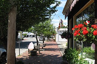
Amherst Center is a census-designated place (CDP) in the City of Amherst in Hampshire County, Massachusetts, United States. The CDP covers the primary village in town. The population was 19,065 at the 2010 census, out of a total town population of 37,819. It is part of the Springfield, Massachusetts Metropolitan Statistical Area.

<span class="mw-page-title-main">South Amherst, Massachusetts</span> Census-designated place in Massachusetts, United States

South Amherst is a census-designated place (CDP) in the town of Amherst in Hampshire County, Massachusetts, United States. The population was 4,994 at the 2010 census. The CDP includes the village of South Amherst and residential subdivisions south of the Amherst town center.

<span class="mw-page-title-main">South Duxbury, Massachusetts</span> Census-designated place in Massachusetts, United States

South Duxbury is a census-designated place (CDP) in the town of Duxbury in Plymouth County, Massachusetts, United States. The population was 3,360 at the 2010 census.

<span class="mw-page-title-main">White Island Shores, Massachusetts</span> Census-designated place in Massachusetts, United States

White Island Shores is a census-designated place (CDP) in the town of Wareham in Plymouth County, Massachusetts, United States, along the shores of White Island Pond. The population was 2,106 at the 2010 census.

<span class="mw-page-title-main">Princeton North, New Jersey</span> Populated place in Mercer County, New Jersey, US

Princeton North, also known as North Princeton, is an unincorporated community that is located in Princeton, in Mercer County, in the U.S. state of New Jersey. As of the 2000 census, the CDP population was 4,528. While the area was categorized as a census-designated place in the 2000 Census, the CDP status was eliminated by the United States Census Bureau as of the 2010 census. The community is located in what was formerly Princeton Township.

<span class="mw-page-title-main">Great Barrington (CDP), Massachusetts</span> Census-designated place in Massachusetts, United States

Great Barrington is a census-designated place (CDP) located in the town of Great Barrington in Berkshire County, Massachusetts, United States. The population was 2,231 at the 2010 census, out of 7,104 in the entire town of Great Barrington.

<span class="mw-page-title-main">Essex (CDP), Massachusetts</span> Census-designated place in Massachusetts, United States

Essex CDP is a census-designated place (CDP) in the town of Essex in Essex County, Massachusetts, United States. The population was 1,471 at the 2010 census.

<span class="mw-page-title-main">Palmer (CDP), Massachusetts</span> Former CDP in Massachusetts, United States

Palmer is former census-designated place (CDP) in Hampden County, Massachusetts, United States. The population was 3,900 at the 2000 census. It is part of the Springfield, Massachusetts Metropolitan Statistical Area. The area is more commonly known as Depot Village, named for the ornate train depot built there by famed architect H.H. Richardson

<span class="mw-page-title-main">Belchertown (CDP), Massachusetts</span> Census-designated place in Massachusetts, United States

Belchertown is a census-designated place (CDP) comprising the central village in the town of Belchertown in Hampshire County, Massachusetts, United States. The population was 2,899 at the 2010 census, out of a total town population of 14,649. It is part of the Springfield, Massachusetts Metropolitan Statistical Area.

<span class="mw-page-title-main">Granby (CDP), Massachusetts</span> Census-designated place in Massachusetts, United States

Granby is a census-designated place (CDP) comprising the main village in the town of Granby in Hampshire County, Massachusetts, United States. The population of the CDP was 1,368 at the 2010 census, out of a total town population of 6,240. It is part of the Springfield, Massachusetts Metropolitan Statistical Area.

<span class="mw-page-title-main">Northborough (CDP), Massachusetts</span> CDP in Massachusetts, United States

Northborough is a census-designated place (CDP) in the town of Northborough in Worcester County, Massachusetts, United States. The population was 6,474 at the 2020 United States census.

<span class="mw-page-title-main">West Brookfield (CDP), Massachusetts</span> Census-designated place in Massachusetts, United States

West Brookfield is a census-designated place (CDP) in the town of West Brookfield in Worcester County, Massachusetts, United States. The population was 1,413 at the 2010 census.

<span class="mw-page-title-main">Hudson (CDP), Massachusetts</span> Census-designated place in Massachusetts, United States

Hudson is a census-designated place (CDP) comprising the densely developed central part of the town of Hudson in Middlesex County, Massachusetts, United States. The population of the CDP was 15,749 at the 2020 census, out of 20,092 in the entire town.

<span class="mw-page-title-main">Amherst (CDP), New Hampshire</span> Census-designated place in New Hampshire, United States

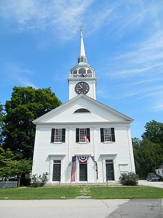
Amherst is a census-designated place (CDP) and the main village in the town of Amherst in Hillsborough County, New Hampshire, United States. The population of the CDP was 697 at the 2020 census, out of 11,753 in the entire town. The village center is listed on the National Register of Historic Places as the Amherst Village Historic District.

References

  1. 1 2 "Geographic Identifiers: 2010 Census Summary File 1 (G001): North Amherst CDP, Massachusetts". American Factfinder. U.S. Census Bureau. Archived from the original on February 13, 2020. Retrieved August 10, 2017.
  2. "US Gazetteer files: 2010, 2000, and 1990". United States Census Bureau. February 12, 2011. Retrieved April 23, 2011.
  3. "TIGERweb: North Amherst CDP, Massachusetts". Geography Division, U.S. Census Bureau. Retrieved August 10, 2017.
  4. Hofherr, Justine (March 25, 2015). "There Are Teeny Tiny Underpasses for Salamanders in Massachusetts". www.boston.com. Boston globe Media Partners, LLC. Retrieved May 21, 2024.
  5. "U.S. Census website". United States Census Bureau . Retrieved January 31, 2008.