Ohio River Bridges Project

Last updated

Ohio River Bridges Project
Location Louisville, Kentucky and Clark County, Indiana
CountryUnited States
EstablishedJuly 26, 2002 (2002-07-26)
StatusComplete
Website kyinbridges.com

The Ohio River Bridges Project was a transportation project in the Louisville metropolitan area involving the reconstruction of the Kennedy Interchange (locally known as "Spaghetti Junction"), the completion of two new Ohio River bridges, and the reconstruction of ramps on Interstate 65 between Muhammad Ali Boulevard and downtown Louisville.

Contents

The Abraham Lincoln Bridge, opened December 2015, is located downtown and slightly upstream from the John F. Kennedy Memorial Bridge that had been completed in 1963. It carries northbound traffic on Interstate 65. The other, the Lewis and Clark Bridge (called the East End Bridge during planning), opened in December 2016 and connects the Indiana and Kentucky segments of I-265 between Prospect, Kentucky, and Utica, Indiana.

On July 26, 2002, the two governors of Kentucky and Indiana announced that the East End Bridge would be constructed, along with a new I-65 downtown span and a reconstructed Kennedy Interchange, where three interstates connect. The cost of the three projects was to total approximately $2.5 billion, [1] and would be the largest transportation project ever constructed between the two states. An estimated 132 residents and 80 businesses were to be displaced.

The Louisville–Southern Indiana Bridge Authority (LSIBA), a 14-member commission (seven members from Kentucky and seven from Indiana) charged with developing a financial plan and establishing funding mechanisms for construction, was established in October 2009. The LSIBA oversaw construction of the project, and continues to operate and maintain the bridges and collect tolls. Construction began in 2014, with the entire project being completed in late December 2016. [2] Tolling on the bridges is expected to continue through at least 2053. [3]

Lewis and Clark Bridge

The result of many community discussions for over 30 years, the Lewis and Clark Bridge (known as the East End Bridge from its conception until completion of construction) is part of a new 6.5 mile (10.5 km) highway that connects the formerly disjoint sections of I-265 in Indiana and Kentucky. With the new section complete, I-265 forms a 3/4 beltway around the Louisville metropolitan area.

Design A-15 was chosen over six alternatives for the I-265 connection, which includes the Lewis and Clark Bridge Bridge. A tunnel for the new highway was constructed under the historic Drumanard Estate in Kentucky because the property is listed on the National Register of Historic Places. The interstate reappears from the tunnel near the Shadow Wood subdivision before crossing Transylvania Beach and the Ohio River. The highway passes north of Utica, Indiana, near the old Indiana Army Ammunition Plant. Construction of an exploratory tunnel under the historic east end property was to begin in summer 2007, but bids were 39% more than the state had expected. Construction of the exploratory tunnel finally started in April 2011. [4]

The design is the result of the $22.1 million, four-year Ohio River Bridges Study, which found that solving the region's traffic congestion would require the construction of two new bridges across the Ohio River and reconstruction of the Kennedy Interchange in downtown Louisville.

Limited land acquisition began in 2004, with the number of homes taken by eminent domain expected to be higher because of development occurring in the route path. 109 residences, most in Clark County, Indiana were displaced, the majority of which were constructed in the year before the route for the I-265 extension was finalized. Half of the Shadow Wood subdivision and two condominium buildings at Harbor of Harrods Creek in Jefferson County, Kentucky, were razed.

The only new interchange along the 6.5-mile (10.5 km) eastern route is in Indiana at Salem Road. That full interchange provides access to the Clark Maritime Center and the old Indiana Army Ammunition Plant, a 10,000-acre (40 km2) site that has been undergoing redevelopment as the River Ridge Commerce Center.

The bridge includes accommodations for pedestrians and bicyclists. Former Indiana Governor Frank O'Bannon said he could not wait for construction to begin, adding, "We'll finally be able to take down that sign at the end of Interstate 265 near the Clark Maritime Center that says 'No Bridge to Kentucky,'" he said to applause.

In September 2005, the Kentucky Transportation Cabinet released plans to reconstruct the U.S. Highway 42 interchange and rebuild the "super-two" roadway from I-71 north to the interchange. The super-two roadway already had a right of way wide enough for a six lane freeway, although at the time only two lanes worth of space is being used. The incomplete US 42 interchange had been constructed in the early 1960s with the original construction of Interstate 265. The reconstruction of the northern two miles (3 km) included the widening of the super-two alignment to six-lanes, the rebuilding and widening of the ramps at US 42, the installation of two traffic signals at the base of the ramps, and stub roadways that would eventually lead into the tunnel under the Drumanard Estate to the immediate north of the interchange.

On July 19, 2006, the final design alternatives for the East End Bridge were announced. The three designs chosen included a cable-stayed bridge with two diamond-shaped towers with the cables reaching to the outside; a cable-stayed two-tower bridge with the towers in the center of the bridge deck and cables reaching to the outside; and a cable-stayed two center towered bridges with the cables extending to the center of the deck. It was also announced that the new bridge would cost $221 million and feature three northbound and three southbound lanes. [1] In 2011, this was scaled back in order to save money by narrowing the bridge deck configuration to have only two lanes in each direction (but with the future ability to re-stripe for three by narrowing shoulders) and by slightly narrowing the pedestrian/bicycle lane, resulting in a total 23 feet (7.0 m) reduction in overall deck width. [5] The bridge opened to the public on December 18, 2016. [6] Tolling began on December 30, 2016. [7]

Abraham Lincoln Bridge

The Abraham Lincoln Bridge, completed in 2015, runs parallel to the John F. Kennedy Memorial Bridge downstream and now carries six lanes of northbound I-65 traffic. Pedestrian and bicycle lanes were in the original plans, but were removed. [8] The existing I-65 Kennedy Memorial Bridge, completed in 1963, was renovated for six lanes of southbound traffic. The Lincoln Bridge opened for northbound traffic only on December 6, 2015, with southbound traffic being rerouted onto it later that month as reconstruction of the Kennedy Bridge began. [9] The Lincoln began carrying northbound traffic only on October 10, 2016, when the Kennedy reopened for southbound I-65 through traffic; [10] the Kennedy itself fully reopened on November 14, 2016. [11]

A Structured Public Involvement protocol developed by K. Bailey and T. Grossardt was used to elicit public preferences for the design of the structure. From spring 2005 to summer 2006, several hundred citizens attended a series of public meetings in Louisville, Kentucky, and Jeffersonville, Indiana, and evaluated a range of bridge design options using 3D visualizations. This public involvement process focused in on designs that the public felt were more suitable, as shown by their polling scores. The SPI public involvement process itself was evaluated by anonymous, real-time citizen polling at the open public meetings. [12]

On July 19, 2006, the final design alternatives for the bridge were announced. The three designs included a three-span arch, a cable-stayed design with three towers, and a cable-stayed type with a single A-shaped support tower. It was also announced that the projected cost for the bridge would be $203 million. [1]

The new structure is the fourth bridge in downtown Louisville, joining the John F. Kennedy Memorial Bridge erected between spring 1961 and late 1963 at a cost of $10 million; the four-lane George Rogers Clark Memorial Bridge, constructed from June 1928 and to October 31, 1929; and the Big Four Bridge, which operated as a railroad bridge from 1895 to 1969 and reopened as a pedestrian bridge in May 2014.

2008 report

In February 2008, the Kentucky Transportation Cabinet released a study saying that tolls would be a possible part of the new bridges, because there were insufficient federal funds for the $4.1 billion project. The tolling would likely be electronic, without traditional tollbooths, similar to SunPass in Florida. The possibility of tolls was not met with a warm reception; Jeffersonville's city council quickly passed a resolution urging state and federal officials to find other ways to fund the bridges project. [13]

2010 financial plan

The LSIBA issued the updated financial plan for the Ohio River Bridges project on December 16, 2010. The plan envisioned roughly half of the project's costs being financed through $1.00 tolls on the proposed I-65 (northbound) and I-265 and the existing I-65 (southbound) and I-64 Ohio River crossings in the Louisville area. While the financial plan envisioned construction beginning in the summer of 2012, the plan still required approval from the Federal Highway Administration and Congress before work could begin because the existing I-65 and I-64 bridges were built with federal interstate highway funds.

The Kentucky Public Transportation Infrastructure Authority officially approved of the Commonwealth joining the E-ZPass consortium across 15 states and the Canadian province of Ontario on July 29, 2015. [14] Users have the choice of purchasing a traditional E-ZPass transponder for use throughout E-ZPass states, or a decal applied to the windshield for use by mainly local commuters, while occasional travelers can choose to pay their toll by mail via license plate recognition notices.

2011 new issues

On September 9, 2011, Kentucky and Indiana officials announced the closure of the Sherman Minton Bridge. Cracks in bridge support beams found during an inspection on that day led to the bridge closure, which transportation officials indicated would last for an undetermined length of time. The bridge is a major connection between Louisville and Southern Indiana and is Interstate 64's pathway between the states.

The bridge reopened shortly before midnight on February 17, 2012, almost two weeks ahead of a deadline imposed by both states for completion of repairs.

Criticism and alternatives

Like other public works projects, criticism and alternatives have sprung up. Criticism has largely centered around land acquisition and routing issues, as well as concerns that the Butchertown neighborhood would lose a significant portion of its historical infrastructure with its absorption into the reconfigured Kennedy Interchange. A notable alternative to a portion of the project plan, 8664, called for I-64 to be rerouted around downtown using I-265 and the new East End Bridge so that I-64 in downtown could be deconstructed, making way for downtown park and business expansion in its place. One notable critic was the non-profit group River Fields.

The safety and cost effectiveness of the 1,720-foot (520 m) East End Tunnel under the Drumanard Estate, a 1920s-era property on the National Register of Historic Places was questioned. It would be the second longest automobile tunnel in Kentucky, after the Cumberland Gap Tunnel, and the longest allowing Hazmat-containing vehicles to pass through unannounced and without escort. The chief of the Harrods Creek, Kentucky, fire department, which would be first responder to any accident, expressed concern that the proposed tunnel would be considerably more dangerous to travel through and with fewer safety precautions. [15]

See also

Contemporary Louisville area projects

Related Research Articles

<span class="mw-page-title-main">Interstate 64</span> East–west Interstate in eastern US

Interstate 64 (I-64) is an east–west Interstate Highway in the Eastern United States. Its western terminus is at I-70, U.S. Route 40 (US 40), and US 61 in Wentzville, Missouri. Its eastern terminus is at the Bowers Hill Interchange with I-264 and I-664 at Bower's Hill in Chesapeake, Virginia. I-64 connects Greater St. Louis, the Louisville metropolitan area, the Lexington–Fayette metropolitan area, the Charleston metropolitan area, the Greater Richmond Region, and Hampton Roads.

<span class="mw-page-title-main">Interstate 65</span> Interstate Highway from Alabama to Indiana

Interstate 65 (I-65) is a major north–south Interstate Highway in the central United States. As with most primary Interstates ending in 5, it is a major crosscountry, north–south route, connecting between the Great Lakes and the Gulf of Mexico. Its southern terminus is located at an interchange with I-10 in Mobile, Alabama, and its northern terminus is at an interchange with US 12 (US 12), and US 20 in Gary, Indiana, just southeast of Chicago. I-65 connects several major metropolitan areas in the Midwest and Southern US. It connects the four largest cities in Alabama: Mobile, Montgomery, Birmingham, and Huntsville. It also serves as one of the main north–south routes through Nashville, Tennessee; Louisville, Kentucky; and Indianapolis, Indiana, each a major metropolitan area in its respective state.

<span class="mw-page-title-main">Interstate 71</span> Interstate Highway in Ohio and Kentucky

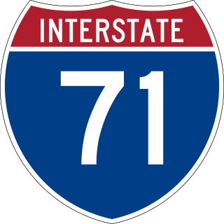
Interstate 71 (I-71) is a north–south Interstate Highway in the midwestern and southeastern regions of the United States. Its southern terminus is at an interchange with I-64 and I-65 in Louisville, Kentucky, and its northern terminus at an interchange with I-90 in Cleveland, Ohio. I-71 runs concurrently with I-75 from a point about 20 miles (32 km) south of Cincinnati, Ohio, into Downtown Cincinnati. While most odd numbered Interstates run north–south, I-71 takes more of a northeast–southwest course, with some east–west sections, and is mainly a regional route serving Kentucky and Ohio. It links I-80 and I-90 to I-70 and ultimately links to I-40. Major metropolitan areas served by I-71 include Louisville, Cincinnati, Columbus, and Cleveland.

<span class="mw-page-title-main">Interstate 895</span> Highway in Maryland

Interstate 895 (I-895) is an auxiliary Interstate Highway in the US state of Maryland. Known as the Harbor Tunnel Thruway, the highway runs 11.44 miles (18.41 km) between one junction with I-95 in Elkridge and another interchange with I-95 on the east side of Baltimore. I-895 is a toll road that crosses the Patapsco River estuary via the Baltimore Harbor Tunnel, connecting U.S. Route 1 (US 1), I-695, and the Baltimore–Washington Parkway in the southwestern suburbs of Baltimore with US 40 on the east side of Baltimore. In conjunction with a pair of spurs, unsigned I-895A and I-895B, I-895 provides access to the tunnel from I-97 and Maryland Route 2 (MD 2) in Glen Burnie. The highway is designed for through traffic by having partial interchanges that require vehicles from almost all starting points to pass through the tunnel and the tunnel toll plaza, where a $1.40-$6.00 toll is charged to passenger vehicles, before exiting the facility.

Interstate 265 (I-265) is a 31.21-mile (50.23 km) Interstate Highway partially encircling the Louisville metropolitan area. Starting from I-65 in the southern part of Louisville, it runs through Jefferson County, Kentucky, crosses the Ohio River on the Lewis and Clark Bridge into Indiana, meets I-65 for a second time, and then proceeds westbound to terminate at the I-64 interchange.

<span class="mw-page-title-main">Interstate 395 (Virginia–District of Columbia)</span> Interstate Highway in the DC area

Interstate 395 (I-395) in Virginia and Washington, D.C., is a 13.79-mile-long (22.19 km) spur route of I-95 that begins at an interchange with I-95 in Springfield and ends at an interchange with US Route 50 (US 50) in Northwest Washington, D.C. It passes underneath the National Mall near the US Capitol and ends at a junction with US 50 at New York Avenue, roughly one mile (1.6 km) north of the 3rd Street Tunnel. Despite its proximity to I-395 in Maryland, the route is unrelated and unconnected.

<span class="mw-page-title-main">William H. Natcher Bridge</span> Bridge in Kentucky to Rockport, Indiana

The William H. Natcher Bridge is a cable-stayed bridge that carries U.S. Highway 231 over the Ohio River. The bridge connects Owensboro, Kentucky to Rockport, Indiana and opened on October 21, 2002. It is named in honor of William Huston Natcher, a former United States Representative who served Kentucky's 2nd Congressional District from 1954 until his death in 1994. The bridge project was named for Natcher only three months before his death. It is owned by the Commonwealth of Kentucky and was commissioned by the Kentucky Transportation Cabinet, in cooperation with the Indiana Department of Transportation and the Federal Highway Administration.

<span class="mw-page-title-main">Kennedy Interchange</span> Highway interchange in Kentucky

The Kennedy Interchange, unofficially, though universally, referred to as Spaghetti Junction, is the intersection of Interstate 64 (I-64), I-65 and I-71 at the northeastern edge of downtown Louisville, Kentucky, United States. It is named for the John F. Kennedy Memorial Bridge, which carries I-65, located immediately to the north of the interchange.

<span class="mw-page-title-main">Sherman Minton Bridge</span> Double-deck through arch bridge spanning the Ohio River at Louisville, carrying I-64

The Sherman Minton Bridge is a double-deck through arch bridge spanning the Ohio River, carrying I-64 and US 150 over the river between Kentucky and Indiana. The bridge connects the west side of Louisville, Kentucky to downtown New Albany, Indiana.

<span class="mw-page-title-main">Interstate 95 in Maryland</span> Interstate Highway in Maryland

Interstate 95 (I-95) is an Interstate Highway running along the East Coast of the United States from Miami, Florida, north to the Canada–United States border at Houlton, Maine. In Maryland, the route is a major highway that runs 110.01 miles (177.04 km) diagonally from southwest to northeast, entering from the District of Columbia and Virginia at the Woodrow Wilson Bridge over the Potomac River, northeast to Maryland's border with Delaware near Elkton. It is the longest Interstate Highway within Maryland and is one of the most traveled Interstate Highways in the state, especially between Baltimore and Washington, D.C., despite alternate routes along the corridor, such as the Baltimore–Washington Parkway, U.S. Route 1 (US 1), and US 29. I-95 also has eight auxiliary routes in the state, the most of any state along the I-95 corridor. Portions of the highway, including the Fort McHenry Tunnel and the Millard E. Tydings Memorial Bridge, are tolled.

<span class="mw-page-title-main">Interstate 95 in Delaware</span> Section of Interstate Highway in New Castle County, Delaware, United States

Interstate 95 (I-95) is an Interstate Highway running along the East Coast of the United States from Miami, Florida, north to the Canada–United States border in Houlton, Maine. In the state of Delaware, the route runs for 23.43 miles (37.71 km) across the Wilmington area in northern New Castle County from the Maryland state line near Newark northeast to the Pennsylvania state line in Claymont. I-95 is the only primary Interstate Highway that enters Delaware, although it also has two auxiliary routes within the state. Between the Maryland state line and Newport, I-95 follows the Delaware Turnpike, a toll road with a mainline toll plaza near the state line. Near Newport, the Interstate has a large interchange with Delaware Route 141 (DE 141) and the southern termini of I-295 and I-495. I-95 becomes the Wilmington Expressway from here to the Pennsylvania state line and heads north through Wilmington concurrent with U.S. Route 202 (US 202). Past Wilmington, I-95 continues northeast to Claymont, where I-495 rejoins the route right before the Pennsylvania state line.

<span class="mw-page-title-main">John F. Kennedy Memorial Bridge</span> Single-deck cantilever bridge that carries southbound I-65 across the Ohio River at Louisville

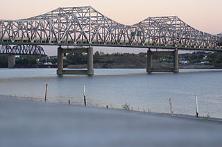
The John F. Kennedy Memorial Bridge is a six-lane, single-deck cantilever bridge that carries southbound Interstate 65 across the Ohio River, connecting Louisville, Kentucky and Jeffersonville, Indiana. The main span is 700 feet (213 m) and the bridge has a total length of 2,498 feet (761 m). The span carries six southbound lanes. It is named after U.S. President John F. Kennedy.

<span class="mw-page-title-main">George Rogers Clark Memorial Bridge</span> Crossing of the Ohio River between Louisville, Kentucky, and Jeffersonville, Indiana

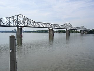
The George Rogers Clark Memorial Bridge, known locally as the Second Street Bridge, is a four-lane cantilevered truss bridge crossing the Ohio River between Louisville, Kentucky, and Jeffersonville, Indiana, that carries US 31.

As with most American cities, transportation in Louisville, Kentucky, is based primarily on automobiles. However, the city traces its foundation to the era where the river was the primary means of transportation, and railroads have been an important part of local industry for over a century. In more recent times Louisville has become a national hub for air cargo, creating over 20,000 local jobs. The city has also launched several initiatives to promote both utilitarian and recreational bicycling. In 2016 Walk Score ranked Louisville 43rd "most walkable" of 141 U.S. cities with a population greater than 200,000. In 2015, 11.7 percent of Louisville households were without a car, which decreased to 10.9 percent in 2016. The national average was 8.7 percent in 2016. Louisville averaged 1.61 cars per household in 2016, compared to a national average of 1.8 per household.

<span class="mw-page-title-main">Interstate 65 in Indiana</span> Highway in Indiana

Interstate 65 (I-65) in the US state of Indiana traverses from the south-southeastern Falls City area bordering Louisville, Kentucky, through the centrally located capital city of Indianapolis, to the northwestern Calumet Region of the Hoosier State which is part of the Chicago metropolitan area. The Indiana portion of I-65 begins in Jeffersonville after crossing the Ohio River and travels mainly north, passing just west of Columbus prior to reaching the Indianapolis metro area. Upon reaching Indianapolis, the route alignment of I-65 begins to run more to the northwest and subsequently passes Lafayette on that city's east and north sides. Northwest of there, in west-central Jasper County, the route again curves more northward as it approaches the Calumet Region. Shortly after passing a major junction with I-80 and I-94, I-65 reaches its northern national terminus in Gary at I-90 which is carried on the Indiana East–West Toll Road. I-65 covers 261.27 miles (420.47 km) in the state of Indiana. This is one of the principal Interstate Highways that cross the state, and, more specifically, intersect at the city of Indianapolis, that has given the state the nickname of "Crossroads of America".

<span class="mw-page-title-main">Bi-State Vietnam Gold Star Bridges</span> Twin-span cantilever bridge between Henderson, Kentucky, and Evansville, Indiana, USA

The Bi-State Vietnam Gold Star Twin Bridges,, are located in Henderson County, Kentucky and connect Henderson, Kentucky, and Evansville, Indiana, along U.S. Route 41 (US 41), two miles (3.2 km) south of the current southern terminus of Interstate 69 (I-69). The two bridges average more than 40,000 vehicles crossings a day across the Ohio River.

<span class="mw-page-title-main">Interstate 65 in Kentucky</span> Interstate Highway in Kentucky, United States

Interstate 65 (I-65) enters the US state of Kentucky from Tennessee, five miles (8.0 km) south of Franklin. It passes by the major cities of Bowling Green, Elizabethtown, and Louisville before exiting the state into Indiana.

<span class="mw-page-title-main">Interstate 64 in Kentucky</span> Highway in Kentucky

Interstate 64 (I-64) in the US state of Kentucky travels for 191 miles (307 km), passing by the major towns and cities of Louisville, Frankfort, Lexington, and Ashland. It has several major junctions with other Interstates, including I-65, I-71, I-264, and I-265 in Louisville and I-75 in Lexington.

<span class="mw-page-title-main">Abraham Lincoln Bridge</span> Cable-stayed bridge carrying northbound I-65 across the Ohio River at Louisville

The Abraham Lincoln Bridge is a six-lane, single-deck cable-stayed bridge carrying northbound Interstate 65 across the Ohio River, connecting Louisville, Kentucky, and Jeffersonville, Indiana. The main span is 700 feet (213 m) and the bridge has a total length of 2,100 feet (640 m). It is named after U.S. President Abraham Lincoln, who was born in Kentucky and grew up in Southern Indiana.

<span class="mw-page-title-main">Lewis and Clark Bridge (Ohio River)</span> Crossing of the Ohio River northeast of downtown Louisville, KY

The Lewis and Clark Bridge is a bridge that crosses the Ohio River northeast of downtown Louisville, Kentucky and is part of a ring road around the Louisville metropolitan area, connecting two previously disjointed segments of Interstate 265. It was known as the East End Bridge for 30 years since its conception and while under construction, and renamed by Indiana officials on the day of its opening, December 18, 2016. The bridge provides for walking and bicycling. For motor vehicles, tolling began on December 30, 2016.

References

  1. 1 2 3 Shafer, Sheldon S. (July 19, 2006). "Bridge options unveiled". The Courier-Journal . Retrieved July 19, 2006.[ dead link ]
  2. "Schedule & Cost". Ohio River Bridges Project. Archived from the original on February 22, 2018.
  3. Ryan, Jacob (November 10, 2015). "More Details On How Tolls Will Work On The Downtown Bridges". WFPL . Retrieved June 21, 2022.
  4. Green, Marcus (September 20, 2007). "Tunnel bids top estimates". The Courier-Journal .
  5. INDOT. "Slide Show Comparing 2003 EIS Alternative with 2011 SDEIS Modified Alternative" (PDF). p. 20.
  6. Kenning, Chris (December 18, 2016). "After decades long wait, East End bridge opens". The Courier-Journal .
  7. Sirianni, Maura; Green, Marcus; Mitchell, Kyle (December 30, 2016). "Tolling begins on the Lewis and Clark, Lincoln and Kennedy bridges". WDRB. Retrieved January 3, 2017. During the first 12 hours of tolling, more than 52,000 vehicles crossed the three toll bridges in the RiverLink system, officials said.
  8. "FHWA Office of Innovative Program Delivery: Project Profiles". Fhwa.dot.gov. Archived from the original on April 14, 2015. Retrieved April 8, 2015.
  9. Schuh, David (December 6, 2015). "Abraham Lincoln Bridge officially opens to northbound traffic". Louisville, KY: WDRB . Retrieved December 7, 2015.
  10. Helmer, Katrina (October 10, 2016). "Kennedy Bridge open 5 lanes of southbound traffic". Louisville, KY: WDRB . Retrieved October 11, 2016.
  11. "UPDATE: All lanes of Kennedy Bridge, including ramp to I-64 West, now open". Louisville: WDRB. November 14, 2016. Retrieved November 18, 2016.
  12. "Structured Public Involvement in Context-Sensitive Large Bridge Design Using Casewise Visual Evaluation: Case Study of Section 2 of Ohio River Bridges Project - Transportation Research Record: Journal of the Transportation Research Board - Volume 2028, Volume 2028 / 2007 Design of Structures 2007 - Transportation Research Board of the National Academies". Trb.metapress.com. February 14, 2008. Archived from the original on January 28, 2013. Retrieved April 8, 2015.
  13. Green, Marcus (February 8, 2008). "Electronic tracking at bridges means no booths". The Courier-Journal . Archived from the original on July 22, 2012.
  14. Green, Marcus (July 29, 2015). "Kentucky joins E-Z Pass for Ohio Bridges Bridges Project". WDRB . Retrieved September 17, 2015.
  15. Green, Marcus (July 16, 2007). "Bridge project tunnels' cost rises; Exploratory shaft will plot path for two others". The Courier-Journal . Archived from the original on June 24, 2011. Retrieved July 16, 2007.

Further reading