
Richland County is located in the U.S. state of South Carolina. As of the 2020 census, its population was 416,147, making it the second-most populous county in South Carolina, behind only Greenville County. The county seat and largest community is Columbia, the state capital. The county was established on March 12, 1785. Richland County is part of the Columbia, SC Metropolitan Statistical Area. In 2020, the center of population of South Carolina was located in Richland County, in the city of Columbia. The county is also the location of the geographic center of South Carolina, southeast of Columbia.
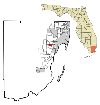
Olympia Heights is a census-designated place in Miami-Dade County, Florida, United States. It is located in the Miami metropolitan area of South Florida. The population was 12,873 at the 2020 census.

Westchester is a census-designated place (CDP) and neighborhood in Miami-Dade County, Florida. It is part of the Miami metropolitan area of South Florida. Prior to the 2020 U.S. Census, the neighboring University Park CDP was merged into Westchester CDP, effectively doubling its geography and population. Per the 2020 census, the population was 56,384.

Cayce is a city in the U.S. state of South Carolina, along the Congaree River. The population was 12,528 at the 2010 census and rose to 13,789 in the 2020 United States Census, and it is the third-most populated municipality in Lexington County. The city is primarily in Lexington County, with additional, predominantly rural land to the east in Richland County. Cayce is part of the Columbia Metropolitan Statistical Area and is within South Carolina's Midlands region.
Seven Oaks is a census-designated place (CDP) in Lexington County, South Carolina, United States, 8 miles (13 km) northwest of downtown Columbia, the state capital. The population of the CDP was 15,144 at the 2010 census. It is part of the Columbia Metropolitan Statistical Area.
Lake Murray of Richland is a census-designated place (CDP) in Richland County, South Carolina, United States. The population was 8,110 at the 2020 census. It is part of the Columbia, South Carolina Metropolitan Statistical Area.

St. Andrews is a census-designated place (CDP) in Richland County, South Carolina, United States. The population was 20,493 at the 2010 census. It is part of the Columbia, South Carolina Metropolitan Statistical Area.
Pauline is an unincorporated community and census-designated place (CDP) in Spartanburg County, South Carolina, United States. It was first listed as a CDP in the 2020 census with a population of 209.

As defined by the U.S. Office of Management and Budget, and used by the U.S. Census Bureau for statistical purposes only, the Columbia, SC Metropolitan Statistical Area, is an area consisting of six counties in central South Carolina, anchored by the city of Columbia. The current population has an estimation of 837,092. It is the second-largest metropolitan statistical area in the state of South Carolina, since the Anderson metropolitan statistical area was combined with Greenville's following the 2010 census.
Long Creek is an unincorporated community and census-designated place (CDP) in western Oconee County, South Carolina, United States. It was first listed as a CDP in the 2020 census with a population of 96.
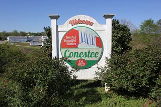
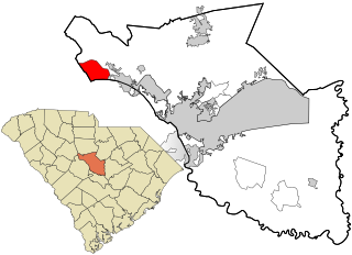
Conestee is an unincorporated community and census-designated place (CDP) in Greenville County, South Carolina, United States. It was first listed as a CDP in the 2020 census with a population of 904.
North Santee is a census-designated place (CDP) in Clarendon County, South Carolina, United States. It was first listed as a CDP prior to the 2020 census with a population of 749.
Live Oak is an unincorporated community and census-designated place (CDP) in Horry County, South Carolina, United States. As of the 2020 census it had a population of 93.
Tradesville is an unincorporated community and census-designated place (CDP) in Lancaster County, South Carolina, United States. It was first listed as a CDP prior to the 2020 census with a population of 253.
Ashwood is an unincorporated community and census-designated place (CDP) in Lee County, South Carolina, United States. It was first listed as a CDP prior to the 2020 census which showed a population of 116.
Edmund is an unincorporated community and census-designated place (CDP) in Lexington County, South Carolina, United States. It was first listed as a CDP in the 2020 census with a population of 969.
Arthurtown is an unincorporated community and census-designated place (CDP) in Richland County, South Carolina, United States. It was listed appeared as a CDP prior to the 2020 census. Its population in 2020 was 2,294.
Capitol View is an unincorporated part of Richland County, South Carolina, United States, consisting of several neighborhoods that are next to the city of Columbia, the state capital. The area was first listed as a census-designated place (CDP) prior to the 2020 census. In 2020 its population was 4,653.
Hilltop is an unincorporated area and census-designated place (CDP) adjacent to the city of Spartanburg in Spartanburg County, South Carolina, United States. It was first listed as a CDP prior to the 2020 census with a population of 3,273.
Baxter Village is a planned community and census-designated place (CDP) in York County, South Carolina, United States. It was first listed as a CDP prior to the 2020 census which showed a population of 4,217.


