Ontario Highway 417

Last updated

Ontario 417.svg TCH-OVR.svg

Highway 417

Queensway (within Ottawa)
Ontario Highway 417
Highway 417 highlighted in red
Route information
Maintained by Ministry of Transportation of Ontario
Length192.0 km [1]  (119.3 mi)
Existed1971 [2] –present
Major junctions
East endQuebec Autoroute 40.svgTrans-Canada Highway shield.svg A-40 (TCH)  Montreal, QC
Major intersectionsOntario 34 crown.svg  Highway 34Vankleek Hill
Ontario 138 crown.svg  Highway 138Casselman
Ontario 416 crown.svg  Highway 416Nepean
Ontario 7 crown.svg  Highway 7Stittsville
West endOntario 17 crown.svgTrans-Canada Highway shield.svg Highway 17  / TCH  Renfrew
Location
Country Canada
Province Ontario
Highway system
Ontario 416.svg Highway 416 Ontario 418.svg Highway 418

King's Highway 417, commonly referred to as Highway 417 and as the Queensway through Ottawa, is a 400-series highway in the Canadian province of Ontario. It connects Ottawa with Montreal via A-40, and is the backbone of the highway system in the National Capital Region. Within Ottawa, it forms part of the Queensway west from Highway 7 to Ottawa Road 174. Highway 417 extends from the Quebec border, near Hawkesbury, to Arnprior, where it continues westward as Highway 17. Aside from the urban section through Ottawa, Highway 417 passes through farmland that dominates much of the fertile Ottawa Valley.

Contents

Within Ottawa, the Queensway was built as part of a grand plan for the city between 1957 and 1966, and later reconstructed to its present form throughout the 1980s. The eastern section, from Gloucester to the Quebec border, opened in 1975 in preparation for the 1976 Montreal Olympics. Sections west of Ottawa have been under construction since the mid-1970s, with the section bypassing Arnprior opening on November 29, 2012 and another 5.3 km stretch in December 2016.

Route description

Highway 417 is a 192.0 km (119.3 mi) controlled-access highway that traverses the lower Ottawa Valley and upper St. Lawrence Valley, bypassing the generally two-lane Highway 17 and providing a high-speed connection between Montreal and Ottawa via A-40. The freeway has also gradually been extended northwest from Ottawa alongside the old highway to its current terminus in Arnprior. Highway 417 currently has 42 interchanges from the Quebec border to Arnprior, with more planned as the highway is extended westward. Unlike other highways in Ontario and most of North America, exits are numbered from east to west. [3] While a significant portion of Highway 417 is a rural four lane freeway divided by a grass median, the section within urban Ottawa is a busy commuter route as wide as ten lanes.

The portion of the route from the Highway 7 interchange east to The Split – a large four-way interchange between Highway 417, Ottawa Regional Road 174 and the Aviation Parkway  – is known formally as the Queensway, although no indication of this name appears on any signage. [4] The Queensway name continues along Ottawa Road 174 from the split with Highway 417 east to Trim Road.

Quebec to Ottawa

Autoroute 40 becomes Highway 417 at the Ontario border; both form the mainline of the Trans-Canada Highway. Welcome to Ontario.jpg
Autoroute 40 becomes Highway 417 at the Ontario border; both form the mainline of the Trans-Canada Highway.

Highway 417 begins at the border between the provinces of Ontario and Quebec, east of which the four lane freeway continues as Autoroute 40. The route proceeds west, south of the former alignment of Highway 17, which it has served to replace. It passes through a forested and agricultural landscape en route to Ottawa, serving the communities of Hawkesbury, Vankleek Hill, Casselman, Limoges and Vars. After approximately 9 km (5.6 mi) the route curves southwest while ramps provide access from the westbound lanes to Prescott and Russell County Road 17 and from County Road 17 to the eastbound lanes of Highway 417. County Road 17 was formerly part of Highway 17 until it was decommissioned as a provincial highway in 1998. The route later meets the southern terminus of Highway 34 at Exit 27. Continuing southwest, the route meanders along the boundary between The Nation and North Glengarry, eventually encountering the northern terminus of Highway  138 — a highway built to connect Highway 417 with Highway 401 and Cornwall [5] — east of Casselman. At this point, the freeway enters The Nation and diverges from the boundary. [3]

After crossing a Via Rail line, the route dips south of Casselman and curves to the west at Exit 66 (County Road 7). It roughly parallels the Via Rail line several kilometres north of the freeway, though significant deviations bypass the communities of Benoit and Limoges; the latter is served by Exit 79 (County Road 5). [3] Near Limoges is the Larose Forest, a man-made forest planted between 1928 and 1980 over the Bourget Desert, itself created as the result of clear cutting in the 19th century. [6] At Exit 88, Highway 417 enters the city of Ottawa, [3] though the surroundings remain unchanged and the highway remains largely rural until Exit 109 (Hunt Club Road), near Ramsayville. [7]

North of Ramsayville, the route jogs abruptly to the west as it crosses Greens Creek and enters the suburbs of Ottawa; an interchange with Innes Road divides the countryside to the south and east from the city to the north and west. [8] The freeway merges with Ottawa Regional Road 174 (also known as the Queensway) at a large two-level interchange known locally as the Split, curving to the west and into downtown Ottawa. This reunites Highway 417 with the former Highway 17, that portion which was renamed as Regional Road 174. The interchange also provides access to Aviation Parkway from westbound Highway 417 and from the parkway to eastbound Highway 417. West of this junction, Highway 417 assumes the route name of the Queensway. [7]

Queensway

Highway 417 facing east at the Split with Ottawa Regional Road 174 Highway 417 near Highway 174.jpg
Highway 417 facing east at the Split with Ottawa Regional Road 174

Within Ottawa, the Queensway extends from Orleans in the east and passes just south of downtown through central Ottawa to Kanata in the west as an urban freeway. Two major interchanges anchor either end of this section: in the east, Highway 417 diverges south towards Montreal at the Split, while the Queensway continues east as Ottawa Regional Road 174 and Aviation Parkway branches north; in the west, Highway 416 travels south to Highway 401. The core section of the Queensway is eight lanes wide, four per carriageway. [9]

The freeway is elevated on a berm along some central portions of the route, providing views of downtown and the Gatineau Hills to the north. This section was constructed along a former Canadian National Railway railbed. [10] The route bisects central Ottawa with downtown and the Parliament Buildings to the north of the highway and residential neighbourhoods including the Glebe to the south. Towards the Richmond Road interchange, the original western terminus of the Queensway, both sides of the freeway are lined by residential subdivisions as the highway transitions back to a suburban setting. [9]

Between Eagleson/March Road and Moodie Drive in the west and between Blair Road and Place d'Orléans Drive in the east, a bus-only shoulder is used by OCTranspo's Transitway rapid-transit network. [11] Several closely spaced exits serve the downtown core of Ottawa, including Nicholas Street, Bronson Avenue and Metcalfe Street; [3] the former was once designated as various provincial highways, most recently Highway 31. [12]

Highway 417 eastbound in Kanata approaching the interchange with Moodie Drive, showing the HOV lane in the eastbound carriageway Highway 417 near Highway 416.jpg
Highway 417 eastbound in Kanata approaching the interchange with Moodie Drive, showing the HOV lane in the eastbound carriageway

West of Highway 416

West of the interchange with Highway 416, the freeway enters the suburb of Kanata [13] and travels through it in an east–west direction. [14] At Exit 145, the route encounters the eastern terminus of Highway 7, which travels southwest to Peterborough and Greater Toronto and provides an alternative route to Highway 401. Highway 417 makes a broad 90-degree curve to the north to meet with the midpoint of the Carp Bypass at the former Highway 44 (now Ottawa Regional Road 49), and at Highway 7, the setting changes from suburban to rural. [3]

The Carp Bypass was built in the mid-1960s as a bypass of the existing Highway 17, which meandered through the communities of Carp, Kinburn and Antrim; the former highway is now Donald B. Munro Drive, and lies to the east of Highway 417. [3] The bypass was built as a two lane road with full control of access, avoiding existing properties and easily facilitating the upgrade to a freeway. North of Antrim, Highway 417 travels in a straight line parallel to old Highway 17 as far as Arnprior, [3] where it curves to cross the Madawaska River. The divided freeway ends west of Campbell Drive, northwest of the town. [15]

History

Queensway

The Queensway facing west from Alta Vista Drive (now Riverside Drive/Vanier Parkway) in 1961 417 Alta Vista overpass 1961.png
The Queensway facing west from Alta Vista Drive (now Riverside Drive/Vanier Parkway) in 1961

Highway 417 was initially constructed as a connection between the existing Queensway and Autoroute 40 in Quebec, [16] the latter being constructed in advance of Expo 1967 and opening December 17, 1966. [17] [18] However, the designation has since been applied to the Queensway west of the interchange between the two freeways. [3]

Construction of the Queensway was driven by the Greber Plan, which was produced by Jacques Gréber under the direction of Prime Minister Mackenzie King in the late 1940s. Although Gréber had been corresponding with King as early as 1936, World War II halted any plans from reaching fruition at that time. Following the war, Gréber was again contacted and his expertise requested. He arrived on October 2, 1945 and began working almost immediately. [19] The Greber Plan, as it came to be known, was released in 1950 and presented to the House of Commons on May 22, 1951. [10] The plan called for the complete reorganization of Ottawa's road and rail network, and included amongst the numerous parkways was an east to west expressway along what was then a Canadian National Railway line. [20] [21]

With the rail lines removed, construction of the new expressway got underway in 1957 when Queen Elizabeth visited Ottawa to open the first session of the 23rd Parliament. On October 15, the Queen detonated dynamite charges from the Hurdman Bridge, which now overlooks the highway as it crosses the Rideau River, and formally dedicated the new project as the Queensway. At the ceremony, premier Leslie Frost indicated that the entire project would cost C$31 million and emphasized the importance of the link to the Trans-Canada Highway. [22] [23]

The Queensway in 1961 over Carling Avenue, following the completion of phase two 417 west from Carling.png
The Queensway in 1961 over Carling Avenue, following the completion of phase two

The Queensway was constructed in four phases, each opening independently: phase one, from Alta Vista Drive (now Riverside Drive) east to Highway 17 (Montreal Road); phase two, from Highway 7 and Highway 15 (Richmond Road) to Carling Avenue; phase three, from Carling Avenue to O'Connor Street; and, phase four, from O'Connor Street to Alta Vista Drive, crossing the Rideau Canal and Rideau River. [24] Phase one opened to traffic on November 25, 1960, extending up to the Rideau River. [2] On the western side of Ottawa, phase two opened a year later in October, 1961. The central section presented the greatest challenge, as an embankment was built to create grade-separations. In addition, the structures over the Rideau Canal and river required several years of construction. On May 15, 1964, the majority of the third phase was ceremonially opened, [25] completing the Carling Avenue interchange and extending the freeway as far as Bronson Avenue. [26] Several months later, on September 17 the short but complicated section east to O'Connor Street was opened. [25] This left only phase four, the central section of the Queensway, which was opened in three segments. On November 26, 1965, the structures over the Rideau Canal were opened to traffic. At the same time, the westbound lanes of the Queensway were extended to Concord Street, located west of the Nicholas Street interchange. [27] The interchange opened on January 1, 1966, allowing travel in both directions over the canal. [28] The final segment, linking the two section of the Queensway, was placed into service on October 28, 1966. [29] Following this, the Highway 17 designation was applied along the Queensway and the old routing renumbered as Highway 17B. [30]

New freeway

Planning was underway on a new freeway, Highway 417, that would run east of Ottawa from the Queensway, connecting with A-40 to provide a high-speed route to Montreal. Highway 17, closely following the shore of the Ottawa River as it meanders towards Pointe-Fortune, was dangerous, narrow, and accident prone, earning it the nickname of "the killer strip". [31] The awarding of the 1976 Summer Olympics to Montreal on May 12, 1970 [32] resulted in an accelerated construction schedule due to the anticipated high volume of traffic that would be travelling the corridor between Ottawa and Montreal during the games. Contracts to construct the new route were opened to bidding on November 15, 1968; construction began in May 1969 starting at Base Line Road (now Ramsayville Road) and proceeding easterly. [33] [34]

The new freeway was built under a continuous construction program over the following 6 years, opening progressively as each segment of roadway was completed. The first 16 km (9.9 mi) segment, from Ramsayville Road to Rockdale Road, near Vars, opened on September 21, 1972. By the end of that month, the easternmost 9 km (5.6 mi) of Highway 17 had been converted into a divided freeway, [35] and construction was progressing on the remainder of the route. [36] On October 1, 1973, a 14 km (8.7 mi) section of freeway opened between Vars and Limoges. [37] On July 15, 1974, Minister of Transportation and Communications John Rhodes ceremonially opened the next section of Highway 417, between Limoges Road and Highland Road. [38] The section between Highland Road and Highway 17 opened on November 8, 1974, connecting with the existing section leading from the Quebec boundary. [39] The final segment of the new route, connecting the section east of Ramsayville with the Queensway, was opened to traffic on December 2, 1975. The cost of the entire eastern segment was $77 million ($351 million in 2021 dollars). [40] [41] The Trans-Canada Highway designation was not applied to this section of Highway 417 until Highway 17 was decommissioned as a provincial route in 1998. [42] [43]

Extensions and expansions

Meanwhile, to the west of Ottawa, planning got underway on a continuation of the Queensway. [44] This extension was designed to connect with the Carp Bypass – a portion of Highway 17 designed to bypass the old meandering route (now known as Donald B. Munro Drive) through Carp, Marathon and Antrim that opened November 9, 1965 [45] – with an interchange and connection to Highway 7. Prior to the completion of this section of freeway, Highway 17 followed Carling Avenue and March Road from Ottawa to west of Carp. Construction began in the west end of Ottawa in 1967. On October 31, 1969, a short extension to Moodie Drive was completed, including the realignment of that road for continuity north and south of Highway 417. [28] [46] [47] The following year, the freeway was extended to March Road. [48] Construction halted at the eastern edge of Kanata for several years while a study was conducted into the merits of building the highway in a trench through the established city. During this time, construction began in 1974 on the future Queensway and Highway 7 interchange. Work also began on the two lane connections to Highway 7 as well as to the Highway 17 and Highway 44 junction west of Carp at the same time. [49]

Map of Highway 417 through Ottawa OntHwy417Ottawa.svg
Map of Highway 417 through Ottawa

Upon the completion of the Ottawa–Quebec section of freeway, the Queensway was designated as Highway 417 west of The Split. [50] With the completion of the Kanata study during early 1976, work began to build the route through the city-centre in a depressed-grade; as a result all the crossings through that section pass over the freeway. By early 1978, the western extension was opened to traffic, providing four lanes between Richmond Road and Highway 7 / 417. The two legs beyond the interchange were initially constructed as two-lane undivided roads, and remained as such for over a decade. [50]

Throughout the 1980s, work on Highway 417 shifted from extensions to expansions. Within Ottawa, the initially four lane route, separated by a wide grass median, was expanded to eight lanes with paved shoulders and centre-mounted lighting beginning in 1982. [51] To reduce weaving, the westbound exit at Kent Street was removed during this work. Expansion of the two lane Highway 17 west of the interchange with Highway 7 got underway in 1991; this section was renumbered as Highway 417 as construction progressed westward. The construction saw a second two lane roadway built parallel to the existing route to create a divided freeway, a process known as twinning. [52]

When the twinning of Highway 17 reached March Road, new contracts were tendered to continue the process northward. Bot Construction was awarded the contract for the section north to Panmure Road on December 9, 1998. [53] On February 16, 2000, the Ministry of Transportation of Ontario (MTO) officially announced that Highway 417 would be extended to Arnprior over the next several years. [54] A contract to build the freeway from north of Panmure Road to south of Arnprior was tendered in early 2002. [55] This work was completed and the extension opened to traffic on September 24, 2004. [56]

Concurrent with the twinning of Highway 7 between Carleton Place and Ottawa, the interchange with Highway 417 was upgraded to support the divided traffic flows; a new flyover ramp was built connecting westbound Highway 417 with westbound Highway 7. Construction began on August 22, 2006, [57] and was opened in June 2008 along with the Highway 7 expansion. [58]

Construction to twin the Arnprior Bypass portion of Highway 17, which included a new interchange at White Lake Road, began during the spring of 2009. [59] The bypass was originally built in 1981 as one of a number of upgrades to Highway 17 between Ottawa and North Bay. It was intended for directing through traffic around downtown Arnprior and was designed for an eventual upgrade to a divided freeway. [60] The major structure in this project was a second crossing of the Madawaska River. [59] Work was completed in late 2012; the new 5.6 km (3.5 mi) section was opened ceremonially on November 29 and cost $63 million, [15] $7 million less than projected. [61]

Starting in 2003, the Ontario Ministry of Transportation developed plans for an extensive upgrade of Highway 417 between Highway 7 (Exit 145) and Anderson Road (Exit 104). The addition of lanes and off-ramps into residential areas was resisted by several local community groups. The study was completed in January 2007 with recommendations to expand or rebuild sections of the highway. The entire length was recommended to be eight lanes wide, and many interchanges will be rebuilt for safety and capacity reasons. In particular, one interchange at Parkdale Avenue will be rebuilt by buying the houses on the south side of Westmount Avenue and moving the ramp to that location thus eliminating the use of Westmount Avenue as the off ramp. The recommendations were significantly scaled back from the beginning of the study process due to public opposition. [62] [63] [64] [ failed verification ]

In August 2007, the Island Park Drive overpass underwent rapid bridge replacement, a novel process in Ontario at the time. The replacement bridge was built nearby in Hampton Park.

In Kanata, Highway 417 was widened from four/six lanes to eight lanes between Highway 416 and Palladium Drive, with the ramp for incoming traffic from Highway 416 being extended as far as Moodie Drive, where it merges to the left side of the westbound carriageway. From Moodie Drive to Palladium Drive the additional leftmost lanes are designated as HOV lanes. Highway 417 was also widened from four to six lanes between Palladium Drive and Highway 7, concurrent with Highway 7 to Carleton Place being upgraded to a freeway including the expansion of its terminus interchange with Highway 417. The work on the westbound lanes was completed in late-October 2014, with the eastbound lanes completed in mid-November 2014. This expansion was intended to relieve congestion, especially when events occur at Canadian Tire Centre. [65]

The segment between Nicholas Street and Ottawa Road 174 was widened with an additional two lanes per direction, construction of which began in 2013 and completed on-time in 2015. The additional pair of lanes were used as bus lanes temporarily, until 2018, at which point they became general traffic lanes. [66] This project involved the replacement of the Nicholas Street and Vanier Parkway overpasses as well as widening the Rideau River bridges. [67] [68]

Future

New grade separation that now carries traffic on Campbell Drive over Highway 417, under construction in August 2015 Ontario Hwy 417 CampbellDrive Aug2015.jpg
New grade separation that now carries traffic on Campbell Drive over Highway 417, under construction in August 2015

The MTO plans to further extend Highway 417 westerly through the Ottawa Valley by twinning and realigning the existing route to a four-lane freeway beyond Arnprior, where it currently merges into a two-laned Highway 17. [69] Route planning has been completed to Pembroke, with a bypass to the east of the Cobden area. The second phase of the extension to be built (phase 1 was the section around Arnprior) is a 5.3 km (3.3 mi) extension past Campbell Drive to Scheel Drive northwest of Arnprior, [15] [70] under construction as of June 26,2014 and completed in 2016. [70] Phases 3 and 4 total 22.5 kilometres (14.0 mi) including four new interchanges and will take the 417 from Scheel Drive to a point 3 kilometres (2 mi) west of Bruce Street (Town of Renfrew). The design stage of this phase was announced in August 2017. [15] [71] [72]

Planning and construction efforts to upgrade Highway 17 through Sudbury and east of North Bay have prompted speculation that Highway 417 will continue to be extended west through Northern Ontario; [73] [74] although no comprehensive conversion plan has been announced to date, Sault Ste. Marie MPP David Orazietti has spearheaded a petition to have the entire highway four-laned from Arnprior to Sault Ste. Marie, [75] similar to the campaign previously undertaken by his caucus colleague Rick Bartolucci regarding the extension of Highway 400. Cheryl Gallant, the federal Member of Parliament for Renfrew—Nipissing—Pembroke, has also advocated the four-laning of the highway through the Ottawa Valley toward North Bay, and ultimately the entire length of the highway throughout Northern Ontario. [76]

Exit list

The following table lists the major junctions along Highway 417, as noted by the Ministry of Transportation of Ontario. [1] Unlike other highways in Ontario, Highway 417 is measured from east to west, [1] and as such this table is presented in that order. 

DivisionLocationkm [1] miExit [3] DestinationsNotes
Prescott and Russell East Hawkesbury 0.00.0Quebec Autoroute 40.svgTrans-Canada Highway shield.svg A-40 (TCH) east Montreal Continuation into Quebec
5.13.25RR 4 jct.svg County Road 4 (Front Road) – Chute-à-Blondeau
RR 14 jct.svg County Road 14 (Prescott & Russell Road) – Saint Eugene
9.55.99RR 17 jct.svg  County Road 17 west – Hawkesbury, Rockland Westbound exit and eastbound entrance; formerly Highway 17 west
16.810.417RR 10 jct.svg County Road 10 (Barb Road) – Vankleek Hill, Saint Eugene
Prescott and Russell  Stormont, Dundas and Glengarry boundary Champlain  North Glengarry boundary27.517.127Ontario 34 crown.svg  Highway 34 north – Vankleek Hill, Hawkesbury
RR 34 jct.svg  County Road 34 south – Alexandria, Lancaster
Formerly Highway 34 south
The Nation  North Glengarry boundary33.821.035RR 23A jct.svg County Road 23A (McCrimmon Road) – Alexandria, Saint BernardinProvides an alternate route to County Road 34 south
50.731.551RR 9 jct.svg County Road 9 north (Ste-Catherine Street) – Saint Isidore
RR 20 jct.svg County Road 20 south (Highland Road) – Saint Elmo, Maxville
The Nation  North Stormont boundary57.835.958Ontario 138 crown.svg  Highway 138 south – Monkland, Cornwall
RR 8 jct.svg County Road 8 north – Casselman, Lemieux
Prescott and Russell Casselman 65.740.866RR 7 jct.svg County Road 7 (Principale Street / St. Albert Road) – Crysler, Saint Albert
The Nation  Russell boundary79.049.179RR 5 jct.svg County Road 5 (Limoges Road) – Limoges, Crysler Provides access to nearby Calypso Park
Ottawa 87.854.688RR 33 jct.svg Road 33 (Rockdale Road) – Vars, Russell, Embrun
95.859.596RR 41 jct.svg Road 41 (Boundary Road) – Metcalfe, Marionville, Russell, Carlsbad Springs
103.564.3104RR 27 jct.svg Road 27 (Anderson Road)
106.966.4109 Ontario M502.svg RR 32 jct.svg Road 32 (Hunt Club Road)Access to Ottawa Macdonald–Cartier International Airport
109.267.9110 Walkley Road (Road 74)
111.669.3112 Innes Road (Road 30)
113.170.3113ARR 174 jct.svg  Road 174 east (Queensway) – Orléans, Rockland Locally known as "The Split"; formerly Highway 17 east
113B Aviation Parkway Westbound exit and eastbound entrance
114.371.0115 St. Laurent Boulevard (Road 26)Westbound exit accessible only from Road 174, no eastbound access from northbound St. Laurent Boulevard
116.072.1117 Vanier Parkway  / Riverside Drive (Road 19)To Ottawa station
117.472.9118Quebec Autoroute 5.svg Nicholas Street (Road 95) to A-5  Gatineau
Mann Avenue
Lees Avenue
To Macdonald-Cartier Bridge
118.673.7119 Metcalfe Street
Catherine Street (Road 60)
119.274.1120 Kent Street Eastbound exit
120.074.6121A Ontario M502.svg Bronson Avenue (Road 79)No eastbound entrance; to Ottawa Macdonald–Cartier International Airport; formerly Highway 17B  / Highway 16  / Highway 31
120.674.9121BRochester StreetEastbound exit and westbound entrance
122.175.9122 Ontario M401.svg Parkdale Avenue (Road 71)To The Ottawa Hospital
123.176.5123 Island Park Drive Westbound exit
123.977.0124 Carling Avenue (Road 38)
Kirkwood Avenue (Road 67)
Formerly Highway 17B
125.878.2126Maitland Avenue (Road 17) Nepean Despite now being part of Ottawa proper and inside the Greenbelt, Nepean is still listed as a destination on exit signage for exits #126 and #127
127.379.1127 Woodroffe Avenue (Road 15) Nepean Signed as exits 127A (north) and 127B (south) westbound; to Fallowfield station
129.480.4129Pinecrest Road / Greenbank Road (Road 13)
130.781.2130 Richmond Road (Road 36)
Holly Acres Road (Road 16)
Bayshore Drive
Signed as Richmond Road / Holly Acres Road (eastbound) and Richmond Road / Bayshore Drive (westbound); formerly Highway 17B east
131.681.8131Ontario 416 crown.svgOntario To 401 crown.svg Highway 416 south to Highway 401  Prescott, Kingston, Toronto Cities not listed on signage; Highway 416 exit 75
133.683.0134Moodie Drive (Road 59)
137.685.5138RR 49 jct.svg Road 49 (March Road / Eagleson Road) – Kanata
139.386.6139Kanata Avenue north / Castlefrank Road  Kanata Westbound exit and eastbound entrance
140.387.2140RR 61 jct.svg Road 61 (Terry Fox Drive) – Kanata
142.788.7142RR 88 jct.svg Road 88 (Palladium Drive) – Kanata Canadian Tire Centre is located just southeast of this exit. The newly-constructed Tanger Outlet Mall, which opened in October 2014, is located on the north side of the interchange.
144.890.0144RR 5 jct.svg Road 5 (Carp Road) – Stittsville, Carp
145.790.5145Ontario 7 crown.svg  TCH-blank.svg   Highway 7  / TCH west – Carleton Place, Toronto
154.996.3155RR 49 jct.svg Road 49 (March Road) – Almonte, Carp Formerly Highway 44 west
163.6101.7163Panmure Road
170.4105.9169RR 20 jct.svg Road 20 (Kinburn Side Road) – Pakenham, Kinburn
180.5112.2180RR 29 jct.svg Road 29 – Arnprior, Carleton Place Formerly Highway 15 south
Renfrew Arnprior 183.9114.3184RR 2 jct.svg County Road 2 (White Lake Road / Daniel Street S.) – Arnprior
McNab/Braeside 187.1116.3187Campbell Drive
192.0119.3Ontario 17.svg  TCH-blank.svg   Highway 17  / TCH west – Petawawa, North Bay Freeway ends; continues east as Highway 17
1.000 mi = 1.609 km; 1.000 km = 0.621 mi

See also

Related Research Articles

<span class="mw-page-title-main">Trans-Canada Highway</span> Transcontinental highway system in Canada

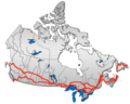
The Trans-Canada Highway is a transcontinental federal–provincial highway system that travels through all ten provinces of Canada, from the Pacific Ocean on the west coast to the Atlantic Ocean on the east coast. The main route spans 7,476 km (4,645 mi) across the country, one of the longest routes of its type in the world. The highway system is recognizable by its distinctive white-on-green maple leaf route markers, although there are small variations in the markers in some provinces.

King's Highway 401, commonly referred to as Highway 401 and also known by its official name as the Macdonald–Cartier Freeway or colloquially referred to as the four-oh-one, is a controlled-access 400-series highway in the Canadian province of Ontario. It stretches 828 kilometres (514 mi) from Windsor in the west to the Ontario–Quebec border in the east. The part of Highway 401 that passes through Toronto is North America's busiest highway, and one of the widest. Together with Quebec Autoroute 20, it forms the road transportation backbone of the Quebec City–Windsor Corridor, along which over half of Canada's population resides. It is also a Core Route in the National Highway System of Canada. The route is maintained by the Ministry of Transportation of Ontario (MTO) and patrolled by the Ontario Provincial Police. The speed limit is 100 km/h (62 mph) throughout its length, with the only exceptions the posted 80 km/h (50 mph) limit westbound in Windsor and in most construction zones, along with a 110 km/h (68 mph) speed limit between Windsor and Tilbury.

<span class="mw-page-title-main">400-series highways</span> Ontario freeway network

The 400-series highways are a network of controlled-access highways in the Canadian province of Ontario, forming a special subset of the provincial highway system. They are analogous to the Interstate Highway System in the United States or the Autoroute system of neighbouring Quebec, and are regulated by the Ministry of Transportation of Ontario (MTO). The 400-series designations were introduced in 1952, although Ontario had been constructing divided highways for two decades prior. Initially, only Highways 400, 401 and 402 were numbered; other designations followed in the subsequent decades. The network is situated almost entirely in Southern Ontario, although Highway 400 extends into the more remote northern portion of the province.

King's Highway 17, more commonly known as Highway 17, is a provincially maintained highway and the primary route of the Trans-Canada Highway through the Canadian province of Ontario. It begins at the Manitoba boundary, 50 km (31 mi) west of Kenora, and the main section ends where Highway 417 begins just west of Arnprior. A small disconnected signed section of the highway still remains within the Ottawa Region between County Road 29 and Grants Side Road. This makes it Ontario's longest highway.

King's Highway 427, also known as Highway 427 and colloquially as the 427, is a 400-series highway in the Canadian province of Ontario that runs from the Queen Elizabeth Way (QEW) and Gardiner Expressway in Toronto to Major Mackenzie Drive in Vaughan. It is Ontario's second busiest freeway by volume and the third busiest in North America, behind Highway 401 and Interstate 405 in California. Like Highway 401, a portion of the route is divided into a collector-express system with twelve to fourteen continuous lanes. Notable about Highway 427 are its several multi-level interchanges; the junctions with the QEW/Gardiner Expressway and Highway 401 are two of the largest interchanges in Ontario and were constructed between 1967 and 1971, while the interchanges with Highway 409 and Highway 407 were completed in 1992 and 1995, respectively.

<span class="mw-page-title-main">Ontario Highway 7</span> Ontario provincial highway

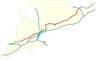
King's Highway 7, commonly referred to as Highway 7 and historically as the Northern Highway, is a provincially maintained highway in the Canadian province of Ontario. At its peak, Highway 7 measured 716 km (445 mi) in length, stretching from Highway 40 east of Sarnia in Southwestern Ontario to Highway 17 west of Ottawa in Eastern Ontario. However, due in part to the construction of Highways 402 and 407, the province transferred the sections of Highway 7 west of London and through the Greater Toronto Area to county and regional jurisdiction. The highway is now 535.7 km (332.9 mi) long; the western segment begins at Highway 4 north of London and extends 154.1 km (95.8 mi) to Georgetown, while the eastern segment begins at Donald Cousens Parkway in Markham and extends 381.6 km (237.1 mi) to Highway 417 in Ottawa.

King's Highway 404, also known as Highway 404 and colloquially as the 404, is a 400-series highway in the Canadian province of Ontario. A continuation of the municipal Don Valley Parkway (DVP) north of Highway 401, it connects Toronto with East Gwillimbury. The 50.1-kilometre (31.1 mi) controlled-access freeway also connects with Highway 407 in Markham, which formed the northeastern ring road of the Greater Toronto Area until the opening of Highway 412 in 2016. Highway 404 provides access to the eastern edge of Richmond Hill, Aurora and Newmarket and the western edge of Whitchurch-Stouffville, in addition to the southern edge of Keswick.

King's Highway 400, commonly referred to as Highway 400, historically as the Toronto–Barrie Highway, and colloquially as the 400, is a 400-series highway in the Canadian province of Ontario linking the city of Toronto in the urban and agricultural south of the province with the scenic and sparsely populated central and northern regions. The portion of the highway between Toronto and Lake Simcoe roughly traces the route of the Toronto Carrying-Place Trail, a historic trail between the Lower and Upper Great Lakes. North of Highway 12, in combination with Highway 69, it forms a branch of the Trans-Canada Highway (TCH), the Georgian Bay Route, and is part of the highest-capacity route from southern Ontario to the Canadian West, via a connection with the mainline of the TCH in Sudbury. The highway also serves as the primary route from Toronto to southern Georgian Bay and Muskoka, areas collectively known as cottage country. The highway is patrolled by the Ontario Provincial Police and has a speed limit of 100 km/h (62 mph), except for the section south of Highway 401, where the speed limit is 80 km/h (50 mph).

King's Highway 403, or simply Highway 403, is a 400-series highway in the Canadian province of Ontario that travels between Woodstock and Mississauga, branching off from and reuniting with Highway 401 at both ends and travelling south of it through Hamilton and Mississauga. It is concurrent with the Queen Elizabeth Way (QEW) for 22 km (14 mi) from Burlington to Oakville. The Highway 403 designation was first applied in 1963 to a short stub of freeway branching off the QEW, and the entire route was completed on August 15, 1997, when the section from Brantford to the then-still independent Town of Ancaster was opened to traffic. The section of Highway 403 between Woodstock and Burlington was formally dedicated as the Alexander Graham Bell Parkway on April 27, 2016, in honour of Alexander Graham Bell.

King's Highway 410, also known as Highway 410 and colloquially as the four-ten, is a 400-series highway in the Canadian province of Ontario that connects Highways 401 and 403 to Brampton. North of Brampton, the commuter freeway ends and the route becomes Highway 10, which continues north through Caledon as a four-lane undivided highway. The route is patrolled by the Ontario Provincial Police and has a speed limit of 100 km/h (62 mph).

King's Highway 402, commonly referred to as Highway 402 and historically as the Blue Water Bridge Approach, is a 400-series highway in the Canadian province of Ontario that connects the Blue Water Bridge international crossing near Sarnia to Highway 401 in London. It is one of multiple trade links between Ontario and the Midwestern United States. It is four lanes for much of its length, though the approach to the Blue Water Bridge is six lanes.

King's Highway 416, commonly referred to as Highway 416 and as the Veterans Memorial Highway, is a 400-series highway in the Canadian province of Ontario that connects the Trans-Canada Highway (Highway 417) in Ottawa with Highway 401 between Brockville and Cornwall. The 76.4-kilometre-long (47.5 mi) freeway acts as an important trade corridor from Interstate 81 between New York and Eastern Ontario via Highway 401, as well as the fastest link between Ottawa and Toronto. Highway 416 passes through a largely rural area, except near its northern terminus where it enters the suburbs of Ottawa. The freeway also serves several communities along its length, notably Spencerville and Kemptville.

King's Highway 16, commonly referred to as Highway 16 and historically as the Prescott Highway, is a provincially maintained highway in the Canadian province of Ontario. The highway once travelled from near Prescott to Ottawa, traversing the distance between the St. Lawrence River and the Ottawa River. However, its length was truncated significantly when most of the route was twinned with a second roadway, and renumbered as Highway 416. A short stub remains through Johnstown, providing access to the Ogdensburg–Prescott International Bridge across the St. Lawrence River to Ogdensburg, New York, where New York State Route 812 continues south.

King's Highway 8, commonly referred to as Highway 8, is a provincially maintained highway in the Canadian province of Ontario. The 159.7-kilometre (99.2 mi) route travels from Highway 21 in Goderich, on the shores of Lake Huron, to Highway 5 in the outskirts of Hamilton near Lake Ontario. Before the 1970s, it continued east through Hamilton and along the edge of the Niagara Escarpment to the American border at the Whirlpool Bridge in Niagara Falls. However, the Queen Elizabeth Way (QEW) replaced the role of Highway 8 between those two cities, and the highway was subsequently transferred from the province to the newly formed Regional Municipality of Niagara in 1970. In 1998, the remaining portion east of Peters Corners was transferred to the city of Hamilton.

The Southwest Bypass and Southeast Bypass are two separately-constructed contiguous roads in the city of Greater Sudbury, in the Canadian province of Ontario, which form a bypass around the southern end of the city's urban core for traffic travelling on Highway 17, a portion of the Trans-Canada Highway. Most of the route is a Super two road with at-grade intersections, with the exception of short section of divided freeway at an interchange with Highway 69. Along with the Northwest Bypass from Lively to Chelmsford, the roads form a partial ring road around the city's urban core.

<span class="mw-page-title-main">Nicholas Street</span> Street in Ottawa, Canada

Nicholas Street is an arterial road in the central area of Ottawa, Ontario which connects Highway 417 with the downtown core. Despite being a municipal road, the street is designated as part of Canada's National Highway System, as part of an interconnecting route between Highway 417 and Quebec Autoroute 5 in Gatineau.

<span class="mw-page-title-main">Ottawa Road 174</span> Controlled-access highway in Ottawa

Ottawa Road 174, formerly Ottawa-Carleton Regional Road 174 and commonly referred to as Highway 174, is a city-maintained road in the City of Ottawa which serves the eastern suburbs of Orléans and Cumberland. The four-lane freeway segment between Highway 417/Aviation Parkway junction to Trim Road is also known as the Queensway, in addition the Queensway name continues to be applied to Highway 417 west of that intersection. Although the road continues through the towns of Rockland and Hawkesbury to the Quebec border, the portion east of the Ottawa city boundary is known as Prescott and Russell County Road 17.

King's Highway 85, commonly referred to as Highway 85, is a provincially maintained highway in the Canadian province of Ontario, connecting Highway 7 to immediately north of the Waterloo city limits. The 10-kilometre (6.2 mi) highway, which is mostly controlled-access, travels through the Regional Municipality of Waterloo along the Conestoga Parkway from its interchange with Highway 7, which continues south along the parkway, to an interchange with Regional Road 15, where it continues as Regional Road 85 to St. Jacobs.

Highway 17B was formerly the designation for six business routes of Highway 17, the main route of the Trans-Canada Highway through the Canadian province of Ontario. Each generally followed the original route of Highway 17 through the town or city that it served, and was subsequently given the Highway 17B designation when a newer bypass route was constructed to either reduce traffic pressure on the local street network, or provide a better thoroughfare that avoided urban areas altogether.

King's Highway 44, commonly referred to as Highway 44, was a provincially maintained highway in the Canadian province of Ontario. The 15.9-kilometre (9.9 mi)-long route began at Highway 15 in the town of Almonte and travelled eastward through Lanark County towards Ottawa, ending at Highway 17. Highway 44 was assumed by the province in 1938 along existing unimproved roadway. A significant portion of the highway was incorporated into a new routing of Highway 17 in 1966. The highway alignment remained generally unchanged for the next three decades until it was decommissioned in 1997 and transferred to Lanark County and what is now the City of Ottawa. The road has since been redesignated as Lanark County Road 49 and Ottawa Road 49.

References

  1. 1 2 3 4 Ministry of Transportation of Ontario (2008). "Annual Average Daily Traffic (AADT) counts". Government of Ontario. Archived from the original on July 6, 2011. Retrieved December 21, 2010.
  2. 1 2 Clark, Glenn (April 14, 2012). A Historical Timeline for the Township of Gloucester. The Gloucester Historical Society. Retrieved July 1, 2012.
  3. 1 2 3 4 5 6 7 8 9 10 Ontario Back Road Atlas (Map). Cartography by MapArt. Peter Heiler. 2010. pp. 65–69. § Q57–S73. ISBN   978-1-55198-226-7.
  4. Bezanson, William (2011). Abandoned Shopping Carts: Personal and Spiritual Responsibility. Trafford Publishing. pp. 139–140. ISBN   9781426989513 . Retrieved June 18, 2012.
  5. Proceedings of the convention (Report). Canadian Good Roads Association. 1969. p. 65.
  6. "The Larose Forest: History and Ecology". The Ottawa Field-Naturalists' Club. Archived from the original on March 5, 2016. Retrieved June 18, 2012.
  7. 1 2 Google (January 21, 2012). "Highway 417 length and route" (Map). Google Maps . Google. Retrieved January 21, 2012.
  8. "Green's Creek". National Capital Commission. Retrieved June 18, 2012.
  9. 1 2 Google (July 1, 2012). "Queensway through Ottawa" (Map). Google Maps . Google. Retrieved July 1, 2012.
  10. 1 2 Gordon, David (1950). Weaving a Modern Plan for Canada's Capital: Jacques Gréber and the 1950 Plan for the National Capital Region. Queen's University. Retrieved June 18, 2012.
  11. "Freeway Shoulder Bus Lanes". City of Ottawa. Retrieved July 1, 2012.
  12. Ontario Road Map (Map). Cartography by Geomatics Office. Ministry of Transportation of Ontario. 1997. Ottawa inset.
  13. "City of Ottawa Act, 1999, S.O. 1999, Chapter 14, Schedule E". ServiceOntario. Retrieved June 18, 2012.
  14. Google (June 16, 2012). "Highway 417 through Kanata" (Map). Google Maps . Google. Retrieved June 16, 2012.
  15. 1 2 3 4 Chase, Sean (November 30, 2012). "Highway 417 opens at Arnprior". The Pembroke Observer. Canoe Sun Media. Retrieved December 2, 2012.
  16. "Two Big Road Jobs". The Ottawa Citizen. Vol. 128, no. 18. July 21, 1970. p. 10. Retrieved December 15, 2011.
  17. "Répertoire des autoroutes du Québec" (in French). Transports Québec. Archived from the original on January 11, 2010. Retrieved December 15, 2011.
  18. Hayes, Bob (December 17, 1966). "Opening Today For 92 Miles Of Autoroute". The Montreal Gazette.
  19. Gréber, Jacques (1950). Plan for the National Capital (Greber Report) Introduction. Queen's University. Retrieved June 18, 2012.
  20. Gréber, Jacques (1950). Plan for the National Capital (Greber Report) Plate 12. Queen's University. Retrieved June 18, 2012.
  21. Gréber, Jacques (1950). Plan for the National Capital (Greber Report) Plate 26. Queen's University. Retrieved June 18, 2012.
  22. Connolley, Greg (October 15, 1957). "City's "Turn" To Play Host At Ceremony". The Ottawa Citizen. Retrieved July 1, 2012.
  23. Robertson, Peter. "The Queensway Began with a Royal Blast: Flashback to 1957". Carlington Community Association. Archived from the original on April 26, 2012. Retrieved June 18, 2012.
  24. Legislative Assembly of Ontario Hansard. Government of Ontario. 1964. p. 1644. Retrieved July 1, 2012.
  25. 1 2 "Chronology". Annual Report (Report). Department of Highways. March 31, 1965. p. 302.
  26. A.T.C. McNab (1964). "Ontario". Proceedings of the... Convention. Canadian Good Roads Association. p. 104.
  27. "Chronology". Annual Report (Report). Department of Highways. March 31, 1966. p. 324.
  28. 1 2 AADT Traffic Volumes 1955–1969 And Traffic Collision Data 1967–1969. Department of Highways. 1970. p. 54.
  29. "Chronology". Annual Report (Report). Department of Highways. March 31, 1967. p. 315.
  30. Ontario Road Map (Map). Cartography by Photogrammetry Division. Ontario Department of Highways. 1968. Ottawa inset.
  31. "Queen's Park to Pay $550,000 More for Fill on Ottawa Highway". The Globe and Mail. Vol. 130, no. 38, 741. Toronto. February 7, 1974.
  32. "International Olympic Committee Vote History". Aleksandr Vernik. Retrieved June 18, 2012.
  33. "Legislative Assembly of Ontario Hansard". Government of Ontario. November 19, 1968. Retrieved June 18, 2012.
  34. "Two Big Road Jobs Ending". The Ottawa Citizen. July 20, 1970. p. 10. Retrieved June 18, 2012.
  35. "Information Services" (Press release). Ministry of Transportation and Communications. September 19, 1972.
  36. Ontario Road Map (Map). Cartography by Photogrammetry Office. Department of Transportation and Communications. 1972. § E30–F33.
  37. Information Services (September 28, 1973). "Another Section of Highway 417 Freeway between Ottawa and the Quebec Boundary will be Opened to Traffic on Monday, October 1" (Press release). Ministry of Transportation and Communications.
  38. Public and Safety Information Branch (July 3, 1974). "Highway 417 Opening" (Press release). Ministry of Transportation and Communications.
  39. Public and Safety Information Branch (November 4, 1974). "[Untitled Announcement]" (Press release). Ministry of Transportation and Communications.
  40. 1688 to 1923: Geloso, Vincent, A Price Index for Canada, 1688 to 1850 (December 6, 2016). Afterwards, Canadian inflation numbers based on Statistics Canada tables 18-10-0005-01 (formerly CANSIM 326-0021) "Consumer Price Index, annual average, not seasonally adjusted". Statistics Canada. Retrieved April 17, 2021. and table 18-10-0004-13 "Consumer Price Index by product group, monthly, percentage change, not seasonally adjusted, Canada, provinces, Whitehorse, Yellowknife and Iqaluit". Statistics Canada. Retrieved April 17, 2021.
  41. Construction Program. Ministry of Transportation and Communications. 1976–1977. p. XII.
  42. Ontario Road Map (Map). Cartography by Geomatics Office. Ministry of Transportation. 1998. §§ C18–D20.
  43. Ontario Road Map (Map). Cartography by Geomatics Office. Ministry of Transportation. 1999. §§ C18–D20.
  44. Construction Program. Ministry of Transportation and Communications. 1972–1973. p. xvii.
  45. "Summary of the Report". Annual Report (Report). Department of Highways. March 31, 1966. pp. xv–xvi.
  46. Ontario Road Map (Map). Cartography by Photogrammetry Office. Department of Highways. 1969. § Q30.
  47. Ontario Road Map (Map). Cartography by Photogrammetry Office. Department of Highways. 1970. § Q30.
  48. Ontario Road Map (Map). Cartography by Photogrammetry Office. Department of Transportation and Communications. 1971. § F30.
  49. Construction Program. Ministry of Transportation and Communications. 1975–1976. p. xix.
  50. 1 2 Construction Program. Ministry of Transportation and Communications. 1976–1977. p. xx.
  51. Provincial Highways Construction Projects. Ministry of Transportation and Communications. 1984–1985. p. xx.
  52. Transportation Capital Branch (1991–1992). "Provincial Highways Construction Projects". Northern Transportation, Construction Projects. Ministry of Transportation and Communications: 17. ISSN   0714-1149.
  53. Ministry of Transportation of Ontario (December 9, 2012). "Twinning On 9.1 Kilometres of Highway 417 Underway West Of Ottawa". Government of Ontario. Archived from the original on November 9, 1999. Retrieved June 15, 2012.
  54. Ministry of Transportation of Ontario (January 21, 2002). "Highway 417 Extended Between Panmure Road in Ottawa and Arnprior". Government of Ontario. Archived from the original on October 2, 2002. Retrieved June 15, 2012.
  55. Ministry of Transportation of Ontario (January 21, 2002). "SuperBuild Investment to Extend Highway 417 to Arnprior". Government of Ontario. Archived from the original on October 2, 2002. Retrieved June 15, 2012.
  56. "Ontario Government Completes Highway 417 Between Ottawa and Arnprior". Government of Ontario. September 24, 2004. Archived from the original on November 18, 2004. Retrieved June 14, 2012.
  57. "Work begins to widen Highway 7 west of Ottawa". Ottawa Business Journal. August 22, 2006. Archived from the original on April 2, 2012. Retrieved May 25, 2012.
  58. Transportation Committee (July 22, 2008). Highway 7 Expansion from Highway 417 to Ashton Station Road - Transfer of Service Roads to the City of Ottawa (Report). City of Ottawa. Retrieved July 1, 2012.
  59. 1 2 DeWolf, Peter (May 1, 2008). "Confusion Over Hwy. 417 Funding". YourOttawaRegion.com. Metroland Media Group. Retrieved June 18, 2012.
  60. Construction Program. Ministry of Transportation and Communications. 1980–1981. p. XXV.
  61. Dixon, Anthony (January 19, 2011). "Expansion is Crucial to Area". The Pembroke Observer. Canoe Sun Media. Archived from the original on January 15, 2013. Retrieved June 18, 2012.
  62. "Queensway Expansion East » Highway 417 Rehabilitation and Widening from west of Maitland Avenue to east of Island Park Drive".
  63. "Ottawa Queensway Preliminary Design and Environmental Assessment Study". Archived from the original on 2014-04-02. Retrieved 2021-02-26.
  64. "Reevely: Based on an old plan and a faulty premise we're spending another $95M to widen Highway 417".
  65. "Transportation — Highway 417 Widening". Ottawa East Community Association. Archived from the original on September 25, 2020. Retrieved August 2, 2012.
  66. "Welcome to the Confederation Line". City of Ottawa. Retrieved August 9, 2014.
  67. "Queensway closing at Nicholas on March 14–15 for construction". 5 March 2020.
  68. "Ontario Newsroom".
  69. "Future Southern Ontario Projects". Ministry of Transportation of Ontario. 2011. Archived from the original on July 1, 2012. Retrieved June 18, 2012.
  70. 1 2 Haaima, Sherry (2014-06-26). "Delays common on 17 west of Arnprior; Check website, twitter for updates, advises MTO". Arnprior Chronicle-Guide. Retrieved 2015-12-05.
  71. Lepack, Tiffany (2017-08-08). "Province confirms design plans for Highway 17 expansion in Renfrew County". InsideOttawaValley.com. Retrieved 2018-04-20.
  72. "Ottawa Valley businesses to benefit from widened Highway 17, official says". 28 May 2020.
  73. Hamilton-McCharles, Jennifer (February 2, 2011). "Exploring Expansion: MTO Studies Highway 17 — Have Your Say". North Bay Nugget. Canoe Sun Media. Archived from the original on March 18, 2012. Retrieved June 16, 2012.
  74. "Highway 17 - Sudbury to Markstay - Project Background". Archived from the original on March 4, 2016. Retrieved June 16, 2012.
  75. Orazietti, David. "4 Lane 17". Archived from the original on November 16, 2016. Retrieved February 14, 2019.
  76. "Cheryl Gallant pushing highway expansion". Pembroke Daily Observer. February 19, 2010. Archived from the original on November 4, 2013. Retrieved February 14, 2019.
Template:Attached KML/Ontario Highway 417
KML is from Wikidata
Preceded by TCH-blank.svg Trans-Canada Highway
Ontario 417.svg Highway 417
Succeeded by
Preceded by