
The Nakhchivan Autonomous Republic is a landlocked exclave of the Republic of Azerbaijan. The region covers 5,502.75 km2 (2,124.62 sq mi) with a population of 459,600. It is bordered by Armenia to the east and north, Iran to the southwest, and Turkey to the west. It is the sole autonomous republic of Azerbaijan, governed by its own elected legislature.

Sadarak District is one of the 7 districts of the Nakhchivan Autonomous Republic of Azerbaijan. The district borders the district of Sharur, as well as the Iğdır Province of Turkey, Ararat Province of Armenia and the West Azerbaijan Province of Iran. Its capital is Heydarabad and largest settlement is Sadarak. As of 2020, the district had a population of 16,100.

Sharur District is one of the 7 districts of the Nakhchivan Autonomous Republic of Azerbaijan. The district borders the districts of Kangarli, Sadarak, as well as the Vayots Dzor and Ararat provinces of Armenia and the West Azerbaijan Province of Iran. Its capital and largest city is Sharur. As of 2020, the district had a population of 117,600.

Babek District is one of the 7 districts of the Nakhchivan Autonomous Republic of Azerbaijan. The district borders the districts of Julfa, Shahbuz, Kangarli, Nakhchivan city, as well as the Vayots Dzor Province of Armenia and the East Azerbaijan and West Azerbaijan provinces of Iran. Its capital and largest city is Babek. As of 2020, the district had a population of 76,200.

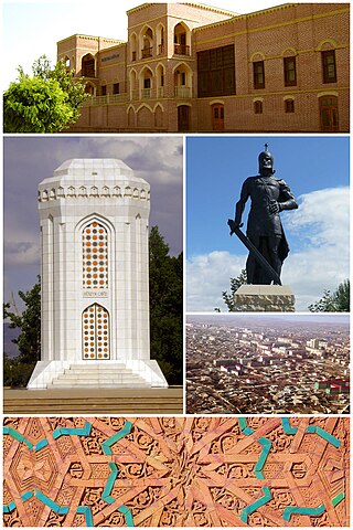
Nakhchivan is the capital and largest city of the eponymous Nakhchivan Autonomous Republic, a true exclave of Azerbaijan, located 450 km (280 mi) west of Baku. The municipality of Nakhchivan consists of the city of Nakhchivan, the settlement of Əliabad and the villages of Başbaşı, Bulqan, Haciniyyət, Qaraçuq, Qaraxanbəyli, Tumbul, Qarağalıq, and Daşduz. It is spread over the foothills of Zangezur Mountains, on the right bank of the Nakhchivan River at an altitude of 873 m (2,864 ft) above sea level.

Shahbuz District is one of the 7 districts of the Nakhchivan Autonomous Republic of Azerbaijan. The district borders the districts of Julfa, Babek, and the Syunik and Vayots Dzor provinces of Armenia. Its capital and largest city is Shahbuz. As of 2020, the district had a population of 25,300.

Julfa District is one of the 7 districts of the Nakhchivan Autonomous Republic of Azerbaijan. The district borders the districts of Ordubad, Babek, Shahbuz, as well as the Syunik Province of Armenia and the East Azerbaijan Province of Iran. Its capital and largest city is Julfa. As of 2020, the district had a population of 47,000.
Julfa, formerly Jugha, is a city and the capital of the Julfa District of the Nakhchivan Autonomous Republic of Azerbaijan.

Kangarli District is one of the 7 districts of the Nakhchivan Autonomous Republic of Azerbaijan. The district borders the districts of Babek, Sharur, Nakhchivan city, as well as the Vayots Dzor Province of Armenia and the West Azerbaijan Province of Iran. Its capital is Givrag, while the largest settlement is Khok. As of 2020, the district had a population of 32,700.

The Nakhichevan Khanate was a khanate under Iranian suzerainty, which controlled the city of Nakhichevan and its surroundings from 1747 to 1828.

Ordubad is the second largest city of Azerbaijan's Nakhchivan Autonomous Republic and the capital of an eponymous district. Ordubad is a medieval city of the Caucasus and in its current capacity of a town was founded in the 18th century. The town is divided into five districts: Ambaras, Kurdtatal, Mingis, Sarshahar, and Uch.

The Erivan Governorate was a province (guberniya) of the Caucasus Viceroyalty of the Russian Empire, with its centеr in Erivan. Its area was 27,830 sq. kilometеrs, roughly corresponding to what is now most of central Armenia, the Iğdır Province of Turkey, and the Nakhchivan exclave of Azerbaijan. At the end of the 19th century, it bordered the Tiflis Governorate to the north, the Elizavetpol Governorate to the east, the Kars Oblast to the west, and Persia and the Ottoman Empire to the south. Mount Ararat and the fertile Ararat Valley were included in the center of the province.

The khanates of the Caucasus, also known as the Azerbaijani khanates, Persian khanates, or Iranian Khanates, were various administrative units in the South Caucasus governed by a hereditary or appointed ruler under the official rule of Iran. The title of the ruler was khan, which was identical to the Ottoman rank of pasha. Following the assassination of Nader Shah in 1747, internal chaos erupted in Iran, particularly in the South Caucasus, where semi-autonomous khanates emerged as a result of the lack of a centralized government. The khans neither had territorial or religious unity, nor an ethnic/national identity. They were mostly interested in preserving their positions and income.
Armenians in Azerbaijan are the Armenians who lived in great numbers in the modern state of Azerbaijan and its precursor, Soviet Azerbaijan. According to the statistics, about 500,000 Armenians lived in Soviet Azerbaijan prior to the outbreak of the First Nagorno-Karabakh War in 1988. Most of the Armenians in Azerbaijan had to flee the republic, like Azerbaijanis in Armenia, in the events leading up to the First Nagorno-Karabakh War, a result of the ongoing Armenian-Azerbaijani conflict. Atrocities directed against the Armenian population took place in Sumgait, Ganja and Baku. Armenians continued to live in large numbers in the region of Nagorno-Karabakh, which was controlled by the break-away state known as the Nagorno-Karabakh Republic from 1991 until the region was forcibly retaken by Azerbaijan in 2023. After the Azerbaijani takeover, almost all Armenians living in Nagorno-Karabakh left the region.
Economy of Nakhchivan covers the issues related to the economy of the city of Nakhchivan, is the most important center of economic activity in Azerbaijan.

Armenians had a historic presence in Nakhchivan. According to an Armenian tradition, Nakhchivan was founded by Noah, of the Abrahamic religions. During the Soviet era, Nakhchivan saw a significant demographic shift. The Armenian population saw a great reduction in their numbers throughout the years repatriating to Armenia. Nakhchivan's Armenian population gradually decreased to around 0%. Still some Armenian political groupings of Armenia and the Armenian diaspora, claim that Nakhchivan should belong to Armenia. The Medieval Armenian cemetery of Jugha (Julfa) in Nakhchivan, regarded by Armenians as the biggest and most precious repository of medieval headstones marked with Christian crosses – khachkars, was completely demolished by 2006.

Western Azerbaijan is an irredentist political concept that is used in the Republic of Azerbaijan mostly to refer to the territory of the Republic of Armenia. Azerbaijani officials claim that the territory of the modern Armenian republic were lands that once belonged to Azerbaijanis. Its claims are primarily hinged over the contention that the current Armenian territory was under the rule of various Turkic tribes, empires and khanates from the Late Middle Ages until the Treaty of Turkmenchay (1828) signed after the Russo-Persian War of 1826–1828. The concept has received official endorsement by the government of Azerbaijan, and has been used by its current president, Ilham Aliyev, who, since around 2010, has made regular reference to "Irevan" (Yerevan), "Göyçə" and "Zangazur" (Syunik) as once and future "Azerbaijani lands". The irredentist concept of "Western Azerbaijan" is associated with other irredentist claims promoted by Azerbaijani officials and academics, including the "Goycha-Zangazur Republic" and the "Republic of Irevan."
The Ordubad uezd was a county (uezd) of the Erivan Governorate of the Caucasus Viceroyalty of the Russian Empire with its center in Ordubad from 1849 until 1868. It included the southern part of the Nakhichevan exclave of present-day Azerbaijan and the southern part of the Syunik Province of present-day Armenia, including Meghri.
Nakhchivan, also transliterated as Nakhichevan may refer to:
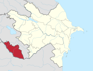
Nakhchivan Economic Region is one of the 14 economic regions of Azerbaijan. It borders Iran to the south, Turkey to the west, and Armenia to the north and east. The region covers the Nakhchivan Autonomous Republic and consists of the districts of Babek, Julfa, Kangarli, Ordubad, Sadarak, Shahbuz, Sharur and the city of Nakhchivan. It has an area of 5,500 square kilometres (2,100 sq mi). Its population was estimated to be at 461.5 thousand people in January 2021.

