Yevlakh District

Last updated
Yevlakh District
Yevlakh District in Azerbaijan 2021.svg
Map of Azerbaijan showing Yevlakh District
Country Flag of Azerbaijan.svg  Azerbaijan
Region Central Aran
Established5 February 1935
Capital Yevlakh
Settlements [1] 50
Government
   Governor Anar Taghiyev
Area
  Total1,470 km2 (570 sq mi)
Population
 (2020) [2]
  Total129,700
  Density88/km2 (230/sq mi)
Time zone UTC+4 (AZT)
Postal code
6600
Website yevlax-ih.gov.az

Yevlakh District (Azerbaijani : Yevlax rayonu) is one of the 66 districts of Azerbaijan. It is located in the centre of the country and belongs to the Central Aran Economic Region. The district borders the districts of Qakh, Shaki, Agdash, Barda, Tartar, Goranboy, and Samukh. Its capital and largest city is Yevlakh. As of 2020, the district had a population of 129,700. [2]

Contents

History

Yevlakh was called as a Yevlakh village of Elisabethpol Governorate on official documents belonging to the beginning of the 19th century, was called as Dzhevanshirsky Uyezd during the years between 1920 and 1935. The Yevlakh region was created on February 20, 1935, by the decision of the Central Executive Committee of the Azerbaijan SSR. Yevlakh became a city on February 1, 1939, according to the decision of the Supreme Soviet of the Azerbaijan SSR.

Yevlakh-Khankendi, Yevlakh-Balakan railway, Yevlakh Airport, Khaldan village secondary school, Chess school, Children's youth sports school, 19 secondary schools with 10535 seats, 15 kindergartens with 840 seats, a hospital, educational establishments, multi-storey residential buildings were commissioned and put into operation. [3] [4]

On 26 December 1962, the Yevlakh area was cancelled and its domain was exchanged to Agdash, Barda and Gasim Ismayilov district by the choice of the 10th session of the Supreme Soviet of the Azerbaijan SSR and turned into the industrial city of Yevlakh republic. Yevlakh has been a free region since 1965.

On 6 January 1965, Yevlakh was included in the list of subordinated cities and the development of industrial undertakings has been started in Yevlakh by the decree of the Presidium of the Supreme Soviet of the Azerbaijani SSR. [5] [6]

Economy

Yevlakh is one of the important agricultural districts of the country. The grain and cotton growing, as well as cattle breeding sectors have played an important role in the city economy. The farmers grow potato, vegetable, water-melon and fruits, as well.

Yevlakh city is also rich with natural resources like clay mixture sand deposits, as well as clay, sand and gravel deposits needed for brick making.

Baku-Gazakh highway, Yevlakh-Balakan, Baku-Tbilisi railway, Baku-Supsa gas and Baku-Tbilisi-Jeyhan oil pipeline extend through the territory of the district. Yevlakh city also has a domestic airport. [7]

Relief

Yevlakh is 293 km far from Baku on the right bank of the Kura waterway. (South-east of Ganja-Gazakh plain, the north-western portion of Shirvan and Garabagh fields). Yevlakh is on the old Silk Way. There are a mild-warm semi-desert and dry field climate within the winter. Kura waterway, Inchachay, Korchay and Alican passes through the domain. In the south eastern portion of Mingachevir water store, the Varvara water store is found in Yevlakh. Upper Garabagh and Upper Shirvan canals are within the district. [5]

Population

Table of population of the district. [8]

Town and Region01.01.200401.01.200501.01.200601.01.200701.01.200801.01.200901.01.201001.01.201101.01.2012
TotalMenWomenTotalMenWomenTotalMenWomenTotalMenWomenTotalMenWomenTotalMenWomenTotalMenWomenTotalMenWomenTotalMenWomen
Yevlakh town111,553,258,3112,653,659,0114,054,259,8115,354,660,7116,455,061,4117,655,462,2118,455,962,5119,656,563,1121,257,363,9
urban population60,528,432,161,228,532,762,028,733,362,728,833,964,029,334,764,729,535,265,129,735,465,530,035,565,930,235,7
Yevlakh town53,825,128,754,425,229,255,125,329,855,725,430,356,925,931,057,626,131,557,926,331,658,326,531,858,726,732,0
Duzdagh settlement0,40,20,20,40,20,20,40,20,20,50,20,30,40,20,20,40,20,20,40,20,20,40,20,20,40,20,2
Meyvaly settlement0,30,10,20,30,10,20,30,10,20,30,10,20,30,10,20,30,10,20,30,10,20,30,10,20,30,10,2
Aran settlement6,03,03,06,13,03,16,23,13,16,23,13,16,43,13,36,43,13,36,53,13,46,53,23,36,53,23,3
rural population51,024,826,251,425,126,352,025,526,552,625,826,852,425,726,752,925,927,053,326,227,154,126,527,655,327,128,2

Education

There are 57 general education schools in the region. Ten of these schools are located in the city and 47 are in the settlements and villages of Yevlakh district. 26 kindergartens operate in Yevlakh district; 7 of them are located in the city and 19 in the villages. In addition, there are 5 educational institutions such as two Children's Youth Sports Schools, Chess School, Children's Creative Center and Technical Creative Center. [3]

Related Research Articles

Articles related to the Azerbaijan Republic include:

<span class="mw-page-title-main">Zardab District</span> District of Azerbaijan

Zardab District is one of the 66 districts of Azerbaijan. It is located in the centre of the country and belongs to the Central Aran Economic Region. The district borders the districts of Agdash, Ujar, Kurdamir, Imishli, Beylagan, Aghjabadi, and Barda. Its capital and largest city is Zardab. As of 2020, the district had a population of 59,300.

<span class="mw-page-title-main">Ujar District</span> District of Azerbaijan

Ujar District is one of the 66 districts of Azerbaijan. It is located in the centre of the country and belongs to the Central Aran Economic Region. The district borders the districts of Agdash, Goychay, Kurdamir, and Zardab. Its capital and largest city is Ujar. As of 2020, the district had a population of 89,500.

<span class="mw-page-title-main">Agdash District</span> District of Azerbaijan

Agdash District is one of the 66 districts of Azerbaijan. It is located in the centre of the country, in the Central Aran Economic Region. The district borders the districts of Yevlakh, Shaki, Oghuz, Qabala, Goychay, Ujar, Zardab, and Barda. Its capital and largest city is Agdash. As of 2020, the district had a population of 111,100.

<span class="mw-page-title-main">Aghstafa District</span> District of Azerbaijan

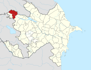
Aghstafa District is one of the 66 districts of Azerbaijan. Located in the northwest of the country, it belongs to the Gazakh-Tovuz Economic Region. The district borders the districts of Qazakh, Tovuz, as well as the Kakheti and Kvemo Kartli regions of Georgia. Its capital and largest city is Aghstafa. As of 2020, the district had a population of 88,500.

<span class="mw-page-title-main">Yevlakh</span> City in Azerbaijan

Yevlakh is a city in Azerbaijan, 265 km west of the capital of Baku. It is surrounded by — but administratively separate from — the Yevlakh District.

<span class="mw-page-title-main">Balakan District</span> District of Azerbaijan

Balakan District is one of the 66 districts of Azerbaijan. It is located in the north of the country, in the Shaki-Zagatala Economic Region. The district borders the district of Zagatala, as well as the Kakheti region of Georgia and the Russian Republic of Dagestan. Its capital and largest city is Balakan. As of 2020, the district had a population of 99,100.

<span class="mw-page-title-main">Barda District</span> District of Azerbaijan

Barda District is one of the 66 districts of Azerbaijan. It is located in the center of the country in the Karabakh Economic Region. The district borders the districts of Tartar, Agdam, Aghjabadi, Zardab, Agdash, and Yevlakh. Its capital and largest city is Barda. As of 2020, the district had a population of 157,500.

<span class="mw-page-title-main">Goranboy District</span> District of Azerbaijan

Goranboy District is one of the 66 districts of Azerbaijan. It is located in the west of the country in the Ganja-Dashkasan Economic Region. The district borders the districts of Kalbajar, Tartar, Yevlakh, Samukh, and Goygol. Its capital and largest city is Goranboy. As of 2020, the district had a population of 105,000.

<span class="mw-page-title-main">Goychay District</span> District of Azerbaijan

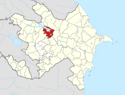
Goychay District is one of the 66 districts of Azerbaijan. Located in the centre of the country, it belongs to Central Aran Economic Region. The district borders the districts of Agdash, Qabala, Ismayilli, Kurdamir, and Ujar. Its capital and largest city is Goychay. As of 2020, the district had a population of 121,700. It is famous for its pomegranate growing industry, and for its pomegranate festival.

<span class="mw-page-title-main">Hajigabul District</span> District of Azerbaijan

Hajigabul District is one of the 66 districts of Azerbaijan. It is located in the east of the country, in the Shirvan-Salyan Economic Region. The district borders the districts of Kurdamir, Agsu, Shamakhi, Gobustan, Absheron, Baku, Salyan, Sabirabad and the city of Shirvan. Its capital and largest city is Hajigabul. As of 2020, the district had a population of 76,600.

<span class="mw-page-title-main">Samukh District</span> District of Azerbaijan

Samukh District is one of the 66 districts of Azerbaijan. It is located in the north-west of the country and belongs to the Ganja-Dashkasan Economic Region. The district borders the districts of Goranboy, Goygol, Shamkir, Tovuz, Qakh, Yevlakh, city of Ganja and the Kakheti region of Georgia. Its capital and largest city is Samukh. As of 2020, the district had a population of 58,800.

<span class="mw-page-title-main">Kurdamir</span> City and municipality in Azerbaijan

Kurdamir is a city and the capital of the Kurdamir District of Azerbaijan. It is located in Aran Economic Region. The city's population is 18,100 people.

<span class="mw-page-title-main">Outline of Azerbaijan</span> Country in the Caucasus region of Eurasia

The following outline is provided as an overview of and topical guide to Azerbaijan:

<span class="mw-page-title-main">Mountainous Shirvan Economic Region</span> Economic region of Azerbaijan

Mountainous Shirvan Economic Region is one of the 14 economic regions of Azerbaijan. It borders the economic regions of Shaki-Zagatala, Guba-Khachmaz, Absheron-Khizi, Shirvan-Salyan, and Central Aran. The region consists of the districts of Agsu, Ismayilli, Gobustan, and Shamakhi. It has an area of 6,130 square kilometres (2,370 sq mi). Its population was estimated to be at 324.8 thousand people in January 2021.

<span class="mw-page-title-main">Aran Economic Region</span> Former economic region in Azerbaijan

Aran Economic Region was one of the 10 economic regions of Azerbaijan. It bordered Iran to the south, as well as the economic regions of Upper Karabakh, Ganja-Gazakh, Shaki-Zagatala, Mountainous Shirvan, Absheron, and Lankaran. The region consisted of the districts of Agdash, Aghjabadi, Barda, Beylagan, Bilasuvar, Jalilabad, Goychay, Hajigabul, Imishli, Kurdamir, Neftchala, Saatly, Sabirabad, Salyan, Ujar, Yevlakh, Zardab and the cities of Mingachevir and Shirvan.

Üçüncü Milli is a village in the Kalbajar District of Azerbaijan. the village is located in the National Village Administrative Territorial District of Kalbajar District of the Republic of Azerbaijan. By the Decision No. 123-XII of the Supreme Council of the Republic of Azerbaijan dated May 25, 1991, the Third National Village of Sinıqkilsa Village Council of Kalbajar District was included in the First National Village Council. It was occupied by the Armed Forces of the Republic of Armenia in 1993. After the tripartite agreement signed by the heads of state of Azerbaijan, Russia and Armenia on November 10, 2020, the Third National Village was evacuated on November 25, 2020.

<span class="mw-page-title-main">Central Aran Economic Region</span> Economic region of Azerbaijan

Central Aran Economic Region is one of the 14 economic regions of Azerbaijan. It borders the economic regions of Shaki-Zagatala, Mountainous Shirvan, Shirvan-Salyan, Mil-Mughan, Karabakh, and Ganja-Dashkasan. The region consists of the districts of Agdash, Goychay, Kurdamir, Ujar, Yevlakh, Zardab, as well as the city of Mingachevir. It has an area of 6,690 square kilometres (2,580 sq mi). Its population was estimated to be at 740 thousand people in January 2021.

<span class="mw-page-title-main">Ganja Oblast</span>

Ganja Oblast was an administrative-territorial unit of the Azerbaijan SSR that existed in 1952 and 1953. The administrative center was the city of Kirovabad. Ganja Oblast is now a region in Azerbaijan, which includes the Agdash, Agstafa, Barda, Dashkasan, Gadabay, Goranboy, Khanlar, Qazakh, Samukh, Shamkir, and Yevlakh rayons.

References

  1. "İnzibati-ərazi vahidləri" (PDF). preslib.az. Retrieved 28 February 2021.
  2. 1 2 "Population of Azerbaijan". stat.gov.az. State Statistics Committee . Retrieved 22 February 2021.
  3. 1 2 "Official page of Yevlakh district".
  4. "TERRITORIAL AND ADMINISTRATIVE UNITS: Yevlakh district" (PDF).
  5. 1 2 "Yevlax rayonu haqqinda ümumi məlumat" [General information about Yevlakh region]. Archived from the original on 2019-02-03. Retrieved 2018-10-18.
  6. "Tarixi | Azərbaycan Respublikası Yevlax şəhər İcra Hakimiyyəti". yevlax-ih.gov.az.
  7. Yevlakh City [ permanent dead link ]
  8. Samadov (www.anarsamadov.net), Anar. "Population". The State Statistical Committee of the Republic of Azerbaijan.

40°40′N47°00′E / 40.667°N 47.000°E / 40.667; 47.000