Paris, New York

Last updated

Paris
NY 12 nb starting descent to New Hartford, July 2023.jpg
NY 12 northbound outside of the hamlet of Paris
Oneida County New York incorporated and unincorporated areas Paris highlighted.svg
Location in Oneida County and the state of New York.
Coordinates: 42°59′0″N75°16′5″W / 42.98333°N 75.26806°W / 42.98333; -75.26806
CountryUnited States
State New York
County Oneida
Government
  Type Town Council
   Town Supervisor Mary Lou McEnroy (D)
   Town Council
Members' List
Area
[1]
  Total31.49 sq mi (81.56 km2)
  Land31.48 sq mi (81.52 km2)
  Water0.02 sq mi (0.04 km2)
Elevation
1,299 ft (396 m)
Population
 (2020) [2]
  Total4,332
  Density137.63/sq mi (53.14/km2)
Time zone UTC-5 (Eastern (EST))
  Summer (DST) UTC-4 (EDT)
ZIP code
13456
Area code 315
FIPS code 36-56330
GNIS feature ID0979341
Website Town website

Paris is a town in Oneida County, New York, United States. The town is in the southeast part of the county and is south of Utica. The population was 4,332 at the 2020 census. [2] The town was named after an early benefactor, Colonel Isaac Paris.

Contents

History

The town was formed in 1792 from part of the town of Whitestown. In 1795, part of Paris was used to found the town of Sherburne (now in Chenango County). In 1827, the town of Kirkland, New York was separated from the town of Paris.

The St. Paul's Church and Cemetery at Paris Hill was listed on the National Register of Historic Places in 1996. [3]

Notable people

Geography

According to the United States Census Bureau, the town has a total area of 31.5 square miles (82 km2), of which 31.5 square miles (82 km2) is land and 0.05% is water.

The eastern town line is the border of Herkimer County.

Demographics

Historical population
CensusPop.Note
1800 4,721
1810 5,41814.8%
1820 6,70723.8%
1830 2,765−58.8%
1840 2,8442.9%
1850 4,28350.6%
1860 3,762−12.2%
1870 3,575−5.0%
1880 3,573−0.1%
1890 3,211−10.1%
1900 2,626−18.2%
1910 2,6591.3%
1920 3,00413.0%
1930 2,994−0.3%
1940 3,0732.6%
1950 3,45912.6%
1960 4,21922.0%
1970 4,5798.5%
1980 4,456−2.7%
1990 4,414−0.9%
2000 4,6094.4%
2010 4,411−4.3%
2020 4,332−1.8%
U.S. Decennial Census [4]

As of the census [5] of 2000, there were 4,609 people, 1,714 households, and 1,273 families. The population density was 146.6 inhabitants per square mile (56.6/km2). There were 1,806 housing units at an average density of 57.4 per square mile (22.2/km2). The racial makeup of the town was 98.31% White, 0.35% African American, 0.07% Native American, 0.22% Asian, 0.02% Pacific Islander, 0.20% from other races, and 0.85% from two or more races. Hispanic or Latino of any race were 0.54% of the population.

There were 1,714 households, out of which 38.4% had children under the age of 18 living with them, 60.3% were married couples living together, 9.3% had a female householder with no husband present, and 25.7% were non-families. 22.2% of all households were made up of individuals, and 9.7% had someone living alone who was 65 years of age or older. The average household size was 2.68 and the average family size was 3.15.

In the town, the population was spread out, with 27.3% under the age of 18, 7.1% from 18 to 24, 28.0% from 25 to 44, 25.6% from 45 to 64, and 12.0% who were 65 years of age or older. The median age was 39 years. For every 100 females, there were 97.0 males. For every 100 females age 18 and over, there were 97.2 males.

The median income for a household in the town was $41,571, and the median income for a family was $50,379. Males had a median income of $35,867 versus $26,315 for females. The per capita income for the town was $18,446. About 6.0% of families and 7.3% of the population were below the poverty line, including 9.7% of those under age 18 and 3.6% of those age 65 or over.

Communities and locations in Paris

Related Research Articles

<span class="mw-page-title-main">Oneida County, New York</span> County in New York, United States

Oneida County is a county in the state of New York, United States. As of February 26, 2024, the population was 226,654. The county seat is Utica. The name is in honor of the Oneida, one of the Five Nations of the Iroquois League or Haudenosaunee, which had long occupied this territory at the time of European encounter and colonization. The federally recognized Oneida Indian Nation has had a reservation in the region since the late 18th century, after the American Revolutionary War.

Scio is a town in Allegany County, New York, United States. The population was 1,625 at the 2020 census. The town is in the southern half of the county and north of the village of Wellsville.

<span class="mw-page-title-main">Warren, New York</span> Town in Herkimer County, New York, US

Warren is a town in Herkimer County, New York, United States. The population was 1,143 at the 2010 census. The town is named after General Joseph Warren, who was killed at the Battle of Bunker Hill. Warren is in the south part of Herkimer County. US 20 passes across the town.

<span class="mw-page-title-main">Winfield (town), New York</span> Town in New York, United States

Winfield is a town in Herkimer County, New York, United States. The population was 2,086 at the 2010 census. The town is named after General Winfield Scott and is in the southwestern corner of the county, south of Utica.

Leyden is a town in Lewis County, New York, United States. The population was 1,785 at the 2010 census. The town is in the southern part of the county and is north of Rome.

<span class="mw-page-title-main">Clayville, New York</span> Village in New York, United States

Clayville is a village in Oneida County, New York, United States. The population was 350 at the 2010 census.

<span class="mw-page-title-main">Marshall, New York</span> Town in New York, United States

Marshall is a town in Oneida County, New York, United States. The population was 2,131 at the 2010 census.

<span class="mw-page-title-main">Sangerfield, New York</span> Town in New York, United States

Sangerfield is a town in Oneida County, New York, United States. The population was 2,561 at the 2010 census. The town is named after Jedediah Sanger, an early settler.

<span class="mw-page-title-main">Vienna, New York</span> Town in New York, United States

Vienna is a town in Oneida County, New York, United States. The population was 5,440 at the 2010 census. The town is named after the capital of Austria.

<span class="mw-page-title-main">Whitestown, New York</span> Town in New York, United States

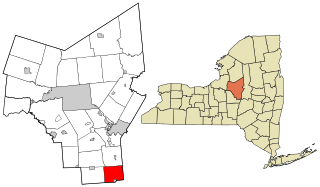
Whitestown is a town in Oneida County, New York, United States. The population was 18,667 at the 2010 census. The name is derived from Judge Hugh White, an early settler. The town is immediately west of Utica and the New York State Thruway passes across the town. The offices of the town of Whitestown are in the Village of Whitesboro.

<span class="mw-page-title-main">West Monroe, New York</span> Town in New York, United States

West Monroe is a town in Oswego County, New York, United States. The population was 4,252 at the 2010 census.

<span class="mw-page-title-main">Williamstown, New York</span> Town in New York, United States

Williamstown is a town in Oswego County, New York, United States. The population was 1,277 at the 2010 census.

<span class="mw-page-title-main">Plainfield, New York</span> Town in New York, United States

Plainfield is a town in Otsego County, New York, United States. The population was 915 at the 2010 census.

<span class="mw-page-title-main">Richfield Springs, New York</span> Village in Otsego County, New York, US

Richfield Springs is a village located in the Town of Richfield, on the north-central border of Otsego County, New York, United States. The population was 1,050 at the 2020 census. The name is derived from local sulfur springs.

Tioga is a town in Tioga County, New York, United States. The population was 4,455 at the 2020 census. The town is in the southwestern part of the county and lies between Elmira and Binghamton. Tioga is situated in the Southern Tier District of New York.

<span class="mw-page-title-main">Sugar Camp, Wisconsin</span> Town in Wisconsin, United States

Sugar Camp is a town in Oneida County, Wisconsin, United States. The population was 1,694 at the 2010 census. The unincorporated community of Sugar Camp is located in the town

<span class="mw-page-title-main">Bridgewater, New York</span> Town in New York, United States

Bridgewater is a town in Oneida County, New York, United States. The population was 1,522 at the 2010 census.

<span class="mw-page-title-main">New Hartford, New York</span> Town in New York, United States

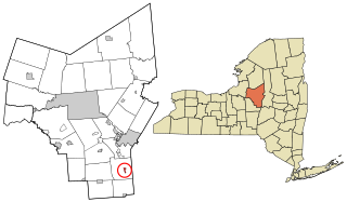
New Hartford is a town in Oneida County, New York, United States. As of the 2020 census, the town population was 21,874. The name of New Hartford was provided by a settler family from Hartford, Connecticut.

<span class="mw-page-title-main">Constantia, New York</span> Town in New York, United States

Constantia is a town in Oswego County, New York, United States. The population was 4,973 at the 2010 census. The town is located in the southeastern part of the county. Within the town is a hamlet and census-designated place of the same name.

<span class="mw-page-title-main">Utica–Rome metropolitan area</span> Metropolitan Statistical Area in New York, United States

The Utica–Rome Metropolitan Statistical Area, as defined by the United States Census Bureau, is an area consisting of two counties in Central New York anchored by the cities of Utica and Rome. As of the 2020 census, the MSA had a population of 292,264.

References

  1. "2020 U.S. Gazetteer Files". United States Census Bureau. Retrieved March 8, 2024.
  2. 1 2 "Profile of General Population and Housing Characteristics: 2020 Demographic Profile Data (DP-1): Paris town, Oneida County, New York". United States Census Bureau . Retrieved March 8, 2024.
  3. "National Register Information System". National Register of Historic Places . National Park Service. March 13, 2009.
  4. "Census of Population and Housing". Census.gov. Retrieved June 4, 2015.
  5. "U.S. Census website". United States Census Bureau . Retrieved January 31, 2008.
  6. 1 2 3 Cassville Digital Raster Quadrangle (Map). 1:24,000. New York State Department of Transportation. 1978. Retrieved January 22, 2010.

43°00′02″N75°18′50″W / 43.00056°N 75.31389°W / 43.00056; -75.31389