Poonch district, India

Last updated

Poonch district
District of Jammu and Kashmir administered by India [1]
A view of Mandi town from Western hills.jpg
View of Mandi Town in Poonch
Poonch district, India
Interactive map of Poonch district
Kashmir region. LOC 2003626427 - showing Jammu division administered by India in neon blue.jpg
Poonch district is in the Jammu division (shown with neon blue boundary) of Indian-administered Jammu and Kashmir (shaded in tan in the disputed Kashmir region [1]
Coordinates(Poonch (town)): 33°42′N74°14′E / 33.700°N 74.233°E / 33.700; 74.233
Administering country India
Union Territory Jammu & Kashmir
Division Jammu
Capital Poonch
Headquarters Poonch
Tehsils [2] 1. Balakote, 2. Haveli, 3. Mandi, 4. Mankote, 5. Mendhar, 6. Surankote
Government
   Lok Sabha Constituency Anantnag - Rajouri
   MP Jugal Kishore Sharma, BJP [3]
   Vidhan Sabha constituencies 3 constituences
   District Magistrate Ch. Mohd. Yasin, IAS
Area
  Total1,674 km2 (646 sq mi)
Elevation
[4]
1,000 m (3,300 ft)
Population
 (2011)228
  Total476,835
  Density280/km2 (740/sq mi)
   Urban
8.1%
Demographics
   Literacy [5] 66.74%
   Sex ratio [5] 893 / 1000
Languages
  Official Dogri, English, Hindi, Kashmiri, Urdu
  Spoken Gojri, Pahari
Time zone UTC+05:30 (IST)
Vehicle registration JK-12
Major highways NH144A-IN.svg NH 144A
Website poonch.nic.in

Poonch or Punch is a district of the Jammu division of Indian-administered Jammu and Kashmir in the disputed Kashmir region. [1] With headquarters in the town of Poonch, it is bounded by the Line of Control (boundary between Indian and Pakistan administered Kashmir) on three sides (north, west and south). The 1947-48 war between India and Pakistan divided the earlier district into two parts. One went to Pakistan and the other became part of the then-Indian state of Jammu and Kashmir. [8]

Contents

Geography

Poonch district has a total area of 1,674 square kilometres (646 sq mi). The district is bordered by Kulgam district, Shopian district and Budgam district in the east, Rajouri district to the south and Baramulla district and Haveli district, Pakistan administered Jammu and Kashmir to the north and Poonch district, Pakistani administered Kashmir to the west.

The district also de-jure includes the areas of Poonch Division under Pakistani control (Bagh District, Haveli District, Poonch District, Sudhanoti District). [9]

Administration

Poonch district, India
Invisible Square.svg
Mapscaleline.svg
15km
10miles
Red pog.svg
Red pog.svg
Bala Kote
Red pog.svg
Mankote
Red pog.svg
Mendhar
Red pog.svg
Surankote
Red pog.svg
Mandi
Red pog.svg
Poonch
(Haveli)
Poonch district tehsils

The district headquarters is in the Poonch city. Presently, district Poonch in Jammu and Kashmir is divided into six tehsils:

Each tehsil has its Tehsildar, who is the administrative head. The district is further divided into eleven. blocks: Poonch, Mandi, Loran Sathra Mendhar, Mankote Balakote, Surankote and Buffliaz. [10] The administrative head of each block is the Block Development Officer (BDO). Each block consists of a number of panchayats. Recently added One Sub Division(Surnkote), other is Mendhar. Poonch district has a total of 179 villages.

Economy

In 2006 the Ministry of Panchayati Raj named Poonch one of the country's 250 most backward districts (out of a total of 640). [11] It is one of the three districts in Jammu and Kashmir currently receiving funds from the Backward Regions Grant Fund Programme (BRGF). [11]

Politics

Poonch district has 3 assembly constituencies: Surankote, Mendhar and Poonch Haveli. On 19 November 2018, the assembly was dissolved by Governor Satya Pal Malik. The former MLA of Poonch Haveli is Shah Mohammed Tantray of JKPDP, Mohammed Akram of Indian National Congress represented the Surankote constituency and Mendhar was represented by Javid Rana of Jammu & Kashmir National Conference. Poonch district comes in Jammu-Poonch Lok Sabha constituency. The present MP of Jammu–Poonch constituency is Jugal Kishore Sharma of the BJP. [3] [12]

Demographics

Historical population
YearPop.±%
1901 102,011    
1911 112,009+9.8%
1921 117,759+5.1%
1931 127,477+8.3%
1941 140,446+10.2%
1951 147,489+5.0%
1961 154,532+4.8%
1971 170,787+10.5%
1981 224,197+31.3%
1991 290,727+29.7%
2001 372,613+28.2%
2011 476,835+28.0%
† 1951 and 1991 populations are estimated
Source: Census of India [13]
Religion in Poonch district (2011) [14]
ReligionPercent
Islam
90.45%
Hinduism
6.84%
Sikhism
2.35%
Other or not stated
0.36%

Languages of Poonch district (2011) [15]

   Pahari (50.21%)
   Gojri (40.39%)
   Kashmiri (5.37%)
   Urdu (1.86%)
  Others (2.17%)

According to the 2011 census Poonch district, India has a population of 476,835, [14] roughly equal to the nation of Suriname. [16] This gives it a ranking of 548th in India (out of a total of 640). The district has a population density of 285 inhabitants per square kilometre (740/sq mi). Its population growth rate over the decade 2001-2011 was 27.97%. Poonch has a sex ratio of 893 females for every 1000 males (which varies with religion), [14] and a literacy rate of 68.69%. The Scheduled Castes and Scheduled Tribes account for 0.1% and 36.9% of the population of the district. [17] The district is 90.45% Muslim. [14]

Religion

As of  2011, the proportions of different religions in the district were as follows: Islam (90.45%), Hinduism (6.84%), Sikhism (2.35%), Christianity (0.20%), not stated (0.15%), and others (0.02%). [14]

Only 8.1% of the district's population lived in urban areas. The proportions of religions in urban areas differed from the district as a whole, being: Islam (51.38%), Hinduism (32.82%), Sikhism (14.62%), Christianity (0.96%), not stated (0.20%), and others (0.03%). [14]

Poonch district: religion, gender ratio, and % urban of population, according to the 2011 Census. [14]
HinduMuslimChristianSikhBuddhistJainOtherNot statedTotal
Total32,604431,27995811,18883102711476,835
6.84%90.45%0.20%2.35%0.02%0.00%0.00%0.15%100.00%
Male23,684220,6366146,4977651386251,899
Female8,920210,6433444,691751325224,936
Gender ratio (% female)27.4%48.8%35.9%41.9%8.4%50.0%50.0%45.7%47.2%
Sex ratio
(no. of females per 1,000 males)
377955560722842893
Urban12,67719,8483715,6478307638,630
Rural19,927411,4315875,5417572635438,205
 % Urban38.9%4.6%38.7%50.5%9.6%30.0%0.0%10.7%8.1%
Sex Ratio in Poonch District in 2011 Census. [14]
(no. females per 1,000 males)
Religion (and population)Sex Ratio
Muslim (pop 431,279)
955
Hindu (pop 32,604)
377
Sikh (pop 11,188)
722
Other (pop 1,764)
630
Total (pop 476,835)
893

Major clans and ethnicities include Gujjars, Bakerwals, Muslim Jats , Mughals, Syeds, Punjabis, Paharis, Kashmiris and Muslim Rajputs. mostly reside on the slopes of mountains. The inhabitants typically cultivate small plots of land, and own some cattle. Gujjars and Bakerwals (nomadic tribes) speak Gojri, apart from Kashmiris the rest of the population speak Pahari-Pothwari, Poonchi, Kaghani besides Punjabi and only a minuscule population may be speaking Dogri. [18] [19]

Transportation

Air

The Poonch Airport is a non-operational airstrip located in Poonch which is mainly used by the Indian Army. The nearest airport is Sheikh ul-Alam International Airport in Srinagar which is located around 180 kilometres from Poonch town.

Rail

There is no railway connectivity to Poonch yet. There are plans to build the Jammu–Poonch line in the near future to connect Poonch with Jammu. [20] The nearest major railway station is Jammu Tawi railway station which is located 235 kilometres from district headquarters Poonch.

Road

Poonch district is connected to the summer capital Jammu by the NH 144A alongside other intra-district roads. It also has road connectivity with Srinagar through the picturesque Mughal Road. There are plans to upgrade the existing NH 144A to four-lane for faster movement of traffic. [21] A bus across the LOC, the Poonch–Rawalakot Bus has helped to re-establish ties across the border.

Education

Schools

See also

Related Research Articles

<span class="mw-page-title-main">Srinagar district</span> District of Jammu and Kashmir, India

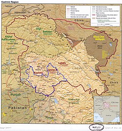
The Srinagar District is an administrative district of Indian-administered Jammu and Kashmir in the disputed Kashmir region. It is one of the 20 districts of Jammu and Kashmir. Situated in the centre of the Kashmir Valley, it is the second-most populous district of the union territory after Jammu District as per the 2011 national census, and is home to the summer capital city of Srinagar. Likewise, the city of Srinagar also serves as the Srinagar District's headquarters.

<span class="mw-page-title-main">Bagh District</span> District of Azad Kashmir administered by Pakistan

Bagh District is a district of Pakistan-administered Azad Kashmir in the disputed Kashmir region. It is one of the ten districts of Azad Jammu and Kashmir. Previously part of Poonch District, Bagh was established as a separate district in 1988.

<span class="mw-page-title-main">Bhimber District</span> District in Azad Jammu and Kashmir, Pakistan

Bhimber District is a district of Pakistan-administered Azad Kashmir in the disputed Kashmir region. It is the southernmost of the 10 districts of Pakistan's territory of Azad Kashmir. It has an area of 1,516 km², and the district headquarter is the town of Bhimber.

<span class="mw-page-title-main">Kotli District</span> District in Azad Kashmir, Pakistan

Kotli District is a district of Pakistan-administered Azad Kashmir in the Azad Kashmir region. It is one of the 10 districts of Pakistan's dependent territory of Azad Kashmir. It is bounded on the north by the Sudhanoti District and the Poonch District, on the north-east by the Poonch District of Indian-administered Jammu and Kashmir, on the south by the Mirpur and Bhimber districts, and on the west by the Rawalpindi District on Pakistan's Punjab Province. Kotli is the biggest district of Azad Kashmir by population and the second biggest by land area, after the Neelum District. The district headquarters is the city of Kotli. The main native languages are Pahari, and Gujari.

<span class="mw-page-title-main">Poonch District, Pakistan</span> District of Azad Kashmir administered by Pakistan

Poonch District is a district of Pakistan-administered Azad Kashmir in the disputed Kashmir region. It is one of the 10 districts of this Pakistan-administered territory. It is bounded on the north by Bagh District, on the north-east by Haveli District, on the south-east by the Poonch District of Indian-administered Kashmir, on the south by Azad Kashmir's Sudhanoti and Kotli districts, and on the west by Rawalpindi District of Pakistan's Punjab Province. The Poonch District is part of the greater Kashmir dispute between India and Pakistan. The district headquarters is the city of Rawalakot. It is the third most populous district of Azad Kashmir.

<span class="mw-page-title-main">Mirpur District</span> District of Azad Jammu and Kashmir, Pakistan

Mirpur District is a district of Pakistan-administered Azad Kashmir in the disputed Kashmir region. It is one of the 10 districts of Pakistan's territory of Azad Kashmir. The Mirpur District is bounded on the north by the Kotli District, on the east by the Bhimber District, on the south by the Gujrat District of Punjab, Pakistan, on the south-west by the Jhelum District of Punjab, Pakistan, and on the west by its Rawalpindi District. The district is named after its main city, Mirpur. The Mirpur District has a population of 456,200 and covers an area of 1,010 km2 (390 sq mi). The district is mainly mountainous with some plains. The Mirpur District has a humid subtropical climate which closely resembles that of the Gujrat District and the Jhelum District, the adjoining districts of Pakistan's Punjab Province.

<span class="mw-page-title-main">Jammu district</span> District of Jammu and Kashmir administered by India

Jammudistrict is an administrative district of the Jammu division of Indian-administered Jammu and Kashmir in the disputed Kashmir region. It is the most populous district in the Jammu division.

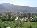
Pulwama is a city and notified area council in the Pulwama district of Indian-administered Jammu and Kashmir in the disputed Kashmir region. It is located approximately 25 kilometres (16 mi) south of the summer capital of the state, Srinagar.

<span class="mw-page-title-main">Gilgit District</span> District of Gilgit-Baltistan in Pakistan

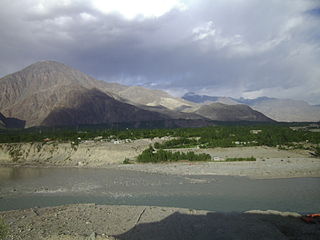
The Gilgit District is one of the 14 districts of Pakistan-administered territory of Gilgit-Baltistan in the disputed Kashmir region. The headquarters of the district is the town of Gilgit. At the 1998 census, the Gilgit District had a population of 243,324. The district includes Gilgit, the Bagrot Valley, Juglot, Danyore, Sultanabad, Naltar Peak, and the Nomal Valley. The highest peak in the district is Distaghil Sar 7,885 metres (25,869 ft), which is the seventh-highest peak in Pakistan and 19th highest in the world.

<span class="mw-page-title-main">Rajouri district</span> District of Jammu and Kashmir administered by India.

Rajouri is a district in the Jammu division of Indian-administered Jammu and Kashmir in the disputed Kashmir region. The Line of Control, between the Indian- and Pakistani-administered Jammu and Kashmir, lies to its west, Poonch to its north, the Reasi district to the east and the Jammu district to its south. Rajouri is famous for its "Kalari". Representing an ancient principality, Rajouri was a joint district, along with Reasi, at the time of princely state's accession to India in 1947. The two tehsils were separated and Rajouri was merged with the Poonch district. Rajouri again became a separate district along with Reasi in 1968 till 2006 when both were separated again. The Rajouri district comprises 13 tehsils (boroughs). The land is mostly fertile and mountainous. Maize, wheat and rice are the main crops of the area and the main source of the irrigation is the river Tawi that originates from the mountains of Pir Panjal.

<span class="mw-page-title-main">Reasi district</span> District of Jammu and Kashmir administered by India

Reasi district is an administrative district in the Jammu division of Indian-administered Jammu and Kashmir in the disputed Kashmir region. The Reasi district is bordered by Udhampur district and Ramban district in the east, Jammu district in the south, Rajouri district in the west and by Kulgam district on the north. The Reasi and Rajouri tehsils formed a joint district called the "Reasi district" at the time of the princely state's accession to India in 1947. As part of the reorganisation, the two tehsils were separated and Reasi was merged with the Udhampur district. It again became a separate district in 2006.

<span class="mw-page-title-main">Samba district</span> District of Jammu and Kashmir administered by India

Samba district is an administrative district in the Jammu division of Indian-administered Jammu and Kashmir in the disputed Kashmir region. It was formed in 2006. Before its formation, this area was part of Jammu district and Kathua district.

<span class="mw-page-title-main">Ramban district</span> District of Jammu and Kashmir administered by India

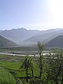
Ramban district is an administrative district in the Jammu division of Indian-administered Jammu and Kashmir in the disputed Kashmir region. It is located in a valley surrounded the Pir Panjal range. It was carved out as a separate district from erstwhile Doda district in 2007. It is located in the Jammu division. The district headquarters are at Ramban town, which is located midway between Jammu and Srinagar along the Chenab river in the Chenab valley on National Highway-44, approximately 151 km from Jammu and Srinagar.

<span class="mw-page-title-main">Bandipore district</span> District of Jammu and Kashmir administered by India

Bandipore district is an administrative district of Indian-administered Jammu and Kashmir in the disputed Kashmir region. It is one of the 20 districts in the Jammu and Kashmir. Bandipore town is the administrative headquarters of the district. Bandipore is located in the foothills of the snow-clad peaks of Harmukh overlooking the shores of Wular Lake and has produced hundreds of scholars and intellectuals. The district is known for its tourist places such as Wular Vintage Park, Athwatoo and Gurez valley. Before 1947, this town was a big trade and literary centre of Kashmir. This district was carved out from the erstwhile Baramulla district in 2007. The district is bounded by Kupwara district from the north, Baramulla district from west and Kargil district in Ladakh and Ganderbal district from the east. This district occupies an area of 398 km2. The district has a population of 392,232 as per 2011 census.

<span class="mw-page-title-main">Haveli District</span> District in Azad Jammu and Kashmir

The Haveli District is a district of Pakistan-administered Azad Kashmir in the disputed Kashmir region. It is one of the 10 districts of the Pakistan-administered territory of Azad Kashmir. It was previously a tehsil of the Bagh District but was promoted to the district status on 1 July 2009.

<span class="mw-page-title-main">Haveli Tehsil</span> Tehsil in Jammu and Kashmir, India

The Haveli Tehsil is a tehsil of the Poonch district in the Indian union territory of Jammu and Kashmir. It is headquartered at the Poonch Town.

<span class="mw-page-title-main">Gilgit Division</span> Administrative division of Pakistan-administered Gilgit-Baltistan

Gilgit Division is an administrative division of Pakistan-administered Gilgit-Baltistan in the disputed Kashmir region. Gilgit is the divisional headquarters of Gilgit Division. Since divisions were restored as an administrative structure in 2008, the division currently consists of six districts:

<span class="mw-page-title-main">Baltistan Division</span> Administrative division of Pakistan-administered Gilgit-Baltistan

Baltistan Division is a first-order administrative division of Pakistan-administered Gilgit-Baltistan in the disputed Kashmir region. It overlaps with the historical Baltistan region.

<span class="mw-page-title-main">Diamer Division</span> Administrative division of Gilgit-Baltistan, Pakistan

Diamer Division, also known as Diamer-Astore Division, is a first-order administrative division of Gilgit-Baltistan region in Pakistan.

<span class="mw-page-title-main">Sheeri, Baramulla</span> Village Block in Jammu & Kashmir, India

Sheeri is a village located in Baramulla district of Jammu and Kashmir, India. The village has two adjoining areas namely "Sheeri Bala" and "Sheeri Payeen". It is located 10 km towards the west of the district headquarters Baramulla and 52 km from the state capital Srinagar. Sheeri is surrounded by Singhpora Tehsil to the east, Rohama Tehsil to the north, Kralpora Tehsil to the south and Boniyar Tehsil to the west.

References

  1. 1 2 3 The application of the term "administered" to the various regions of Kashmir and a mention of the Kashmir dispute is supported by the tertiary sources (a) through (d), reflecting due weight in the coverage. Although "controlled" and "held" are also applied neutrally to the names of the disputants or to the regions administered by them, as evidenced in sources (f) through (h) below, "held" is also considered politicized usage, as is the term "occupied," (see (i) below).
    (a) Kashmir, region Indian subcontinent, Encyclopaedia Britannica, retrieved 15 August 2019 (subscription required) Quote: "Kashmir, region of the northwestern Indian subcontinent ... has been the subject of dispute between India and Pakistan since the partition of the Indian subcontinent in 1947. The northern and western portions are administered by Pakistan and comprise three areas: Azad Kashmir, Gilgit, and Baltistan, the last two being part of a territory called the Northern Areas. Administered by India are the southern and southeastern portions, which constitute the state of Jammu and Kashmir but are slated to be split into two union territories.";
    (b) Pletcher, Kenneth, Aksai Chin, Plateau Region, Asia, Encyclopaedia Britannica, retrieved 16 August 2019 (subscription required) Quote: "Aksai Chin, Chinese (Pinyin) Aksayqin, portion of the Kashmir region, at the northernmost extent of the Indian subcontinent in south-central Asia. It constitutes nearly all the territory of the Chinese-administered sector of Kashmir that is claimed by India to be part of the Ladakh area of Jammu and Kashmir state.";
    (c) "Kashmir", Encyclopedia Americana, Scholastic Library Publishing, 2006, p. 328, ISBN   978-0-7172-0139-6 C. E Bosworth, University of Manchester Quote: "KASHMIR, kash'mer, the northernmost region of the Indian subcontinent, administered partlv by India, partly by Pakistan, and partly by China. The region has been the subject of a bitter dispute between India and Pakistan since they became independent in 1947";
    (d) Osmańczyk, Edmund Jan (2003), Encyclopedia of the United Nations and International Agreements: G to M, Taylor & Francis, pp. 1191–, ISBN   978-0-415-93922-5 Quote: "Jammu and Kashmir: Territory in northwestern India, subject to a dispute betw een India and Pakistan. It has borders with Pakistan and China."
    (e) Talbot, Ian (2016), A History of Modern South Asia: Politics, States, Diasporas, Yale University Press, pp. 28–29, ISBN   978-0-300-19694-8 Quote: "We move from a disputed international border to a dotted line on the map that represents a military border not recognized in international law. The line of control separates the Indian and Pakistani administered areas of the former Princely State of Jammu and Kashmir.";
    (f) Kashmir, region Indian subcontinent, Encyclopaedia Britannica, retrieved 15 August 2019 (subscription required) Quote: "... China became active in the eastern area of Kashmir in the 1950s and has controlled the northeastern part of Ladakh (the easternmost portion of the region) since 1962.";
    (g) Bose, Sumantra (2009), Kashmir: Roots of Conflict, Paths to Peace, Harvard University Press, pp. 294, 291, 293, ISBN   978-0-674-02855-5 Quote: "J&K: Jammu and Kashmir. The former princely state that is the subject of the Kashmir dispute. Besides IJK (Indian-controlled Jammu and Kashmir. The larger and more populous part of the former princely state. It has a population of slightly over 10 million, and comprises three regions: Kashmir Valley, Jammu, and Ladakh.) and AJK ('Azad" (Free) Jammu and Kashmir. The more populous part of Pakistani-controlled J&K, with a population of approximately 2.5 million. AJK has six districts: Muzaffarabad, Mirpur, Bagh, Kodi, Rawalakot, and Poonch. Its capital is the town of Muzaffarabad. AJK has its own institutions, but its political life is heavily controlled by Pakistani authorities, especially the military), it includes the sparsely populated "Northern Areas" of Gilgit and Baltistan, remote mountainous regions which are directly administered, unlike AJK, by the Pakistani central authorities, and some high-altitude uninhabitable tracts under Chinese control."
    (h) Fisher, Michael H. (2018), An Environmental History of India: From Earliest Times to the Twenty-First Century, Cambridge University Press, p. 166, ISBN   978-1-107-11162-2 Quote: "Kashmir’s identity remains hotly disputed with a UN-supervised “Line of Control” still separating Pakistani-held Azad (“Free”) Kashmir from Indian-held Kashmir.";
    (i) Snedden, Christopher (2015), Understanding Kashmir and Kashmiris, Oxford University Press, p. 10, ISBN   978-1-84904-621-3 Quote:"Some politicised terms also are used to describe parts of J&K. These terms include the words 'occupied' and 'held'."
  2. "Administrative Setup Tehsil wise District Poonch ä District Poonch, Government of Jammu and Kashmir ä India".
  3. 1 2 "Lok Sabha Members". Lok Sabha. Retrieved 13 July 2021.
  4. "Agriculture", District Administration, Poonch, Jammu and Kashmir. Developed and hosted by National Informatics Centre, Ministry of Electronics & Information Technology, Government of India, retrieved 19 January 2021
  5. 1 2 "Poonch Census 2011" (PDF). Govt of India Census. Retrieved 13 July 2021.
  6. "The Jammu and Kashmir Official Languages Act, 2020" (PDF). The Gazette of India. 27 September 2020. Retrieved 27 September 2020.
  7. "Parliament passes JK Official Languages Bill, 2020". Rising Kashmir. 24 April 2024. Retrieved 23 September 2020.
  8. "Poonch: A History of Conflict and Division - Azadi Times". 25 June 2023. Retrieved 25 June 2023.
  9. "New Indian map shows UTs of J&K, Ladakh". The Hindu. 2 November 2019.
  10. Statement showing the number of blocks in respect of 22 Districts of Jammu and Kashmir State including newly Created Districts Archived 2008-09-10 at the Wayback Machine dated 2008-03-13, accessed 2008-08-30
  11. 1 2 Ministry of Panchayati Raj (8 September 2009). "A Note on the Backward Regions Grant Fund Programme" (PDF). National Institute of Rural Development. Archived from the original (PDF) on 5 April 2012. Retrieved 27 September 2011.
  12. "ERO's and AERO's". Chief Electoral Officer, Jammu and Kashmir. Archived from the original on 22 October 2008. Retrieved 28 August 2008.
  13. "A-2 Decadal Variation In Population Since 1901". Censusindia.gov.in. Retrieved 9 August 2019.
  14. 1 2 3 4 5 6 7 8 C-1 Population By Religious Community – Jammu & Kashmir (Report). Office of the Registrar General & Census Commissioner, India. Retrieved 28 July 2020.
  15. C-16 Population By Mother Tongue – Jammu & Kashmir (Report). Office of the Registrar General & Census Commissioner, India. Retrieved 18 July 2020.
  16. US Directorate of Intelligence. "Country Comparison:Population". Archived from the original on 13 June 2007. Retrieved 1 October 2011. Suriname 491,989 July 2011 est.
  17. "Punch District Population Religion - Jammu and Kashmir, Punch Literacy, Sex Ratio - Census India". www.censusindia.co.in. Retrieved 10 June 2023.
  18. "Dogri". Ethnologue.
  19. Baba, Yasar Muhammad (2007). My land my people: Kashmir in perspective. Gulshan Books. p. 85. ISBN   9788183390705.
  20. "Start work on Jammu-Poonch rail link". Daily Excelsior. 12 June 2021. Retrieved 13 June 2021.
  21. "Akhnoor-Poonch national highway to be four-lane soon". Amar Ujala. Retrieved 2 April 2021.
  22. "JAWAHAR NAVODAYA VIDAYALAYA, SURANKOTE". navodaya.gov.in. Retrieved 4 August 2023.